Study on Opportunities and Challenges of Collaboration for Geospatial Services
←
→
Page content transcription
If your browser does not render page correctly, please read the page content below

Study on Opportunities and Challenges of
Collaboration for Geospatial Services

                       Das, Anamika
                       Cetl, Vlado (editor)

                       2021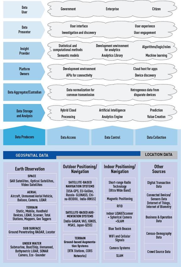
This publication is a report by the Joint Research Centre (JRC), the European Commission’s science and knowledge service. It aims to
provide evidence-based scientific support to the European policymaking process. The scientific output expressed does not imply a policy
position of the European Commission. Neither the European Commission nor any person acting on behalf of the Commission is
responsible for the use that might be made of this publication. For information on the methodology and quality underlying the data used
in this publication for which the source is neither Eurostat nor other Commission services, users should contact the referenced source. The
designations employed and the presentation of material on the maps do not imply the expression of any opinion whatsoever on the part
of the European Union concerning the legal status of any country, territory, city or area or of its authorities, or concerning the delimitation
of its frontiers or boundaries.

Contact information
Name: Vlado Cetl
Address: Via E. Fermi 2749, TP263, I-21027 Ispra (VA), Italy
Email: vlado.cetl@ec.europa.eu
Tel.: +39 0332 783026

Name: Francesco Pignatelli
Address: Via E. Fermi 2749, TP263, I-21027 Ispra (VA), Italy
Email: francesco.pignatelli@ec.europa.eu
Tel.: +39 0332 786319

EU Science Hub
https://ec.europa.eu/jrc

JRC126087

 PDF           ISBN 978-92-76-40674-7                                           doi:10.2760/070456

Luxembourg: Publications Office of the European Union, 2021

© European Union 2021

The reuse policy of the European Commission is implemented by the Commission Decision 2011/833/EU of 12 December 2011 on the
reuse of Commission documents (OJ L 330, 14.12.2011, p. 39). Except otherwise noted, the reuse of this document is authorised under
the Creative Commons Attribution 4.0 International (CC BY 4.0) licence (https://creativecommons.org/licenses/by/4.0/). This means that
reuse is allowed provided appropriate credit is given and any changes are indicated. For any use or reproduction of photos or other
material that is not owned by the EU, permission must be sought directly from the copyright holders.

All content © European Union, 2021, except: Cover, Image of globe by Sergey Nivens, image # 54862255, 2021. Source: stock.adobe.com

How to cite this report: Das, A., Study on Opportunities and Challenges of Collaboration for Geospatial Services, Cetl, V., editor, Publications
Office of the European Union, Luxembourg, 2021, ISBN 978-92-76-40674-7, doi:10.2760/070456, JRC126087.
Contents

Abstract ....................................................................................................................................................................................................................................................................... 2
1 Executive Summary ................................................................................................................................................................................................................................ 3
        1.1 Purpose, Objectives and Scope of Study .............................................................................................................................................................. 3
        1.2 Methodology..................................................................................................................................................................................................................................... 4
        1.3 Structure of the Report .......................................................................................................................................................................................................... 4
2 Location Industry Trends ................................................................................................................................................................................................................... 5
        2.1 Location Industry and Digital Economy ................................................................................................................................................................. 5
        2.2 Location Technology Ecosystem ................................................................................................................................................................................... 5
        2.3 Location Data Key to Fourth Industrial Revolution ..................................................................................................................................... 6
        2.4 Industry Trends .............................................................................................................................................................................................................................. 7
                 2.4.1                Integrating Workflow ............................................................................................................................................................................................. 8
                 2.4.2                Miniaturization of Sensors................................................................................................................................................................................ 8
                 2.4.3                Expanding Wireless and Web Networks .............................................................................................................................................. 8
                 2.4.4  Advancement of Mobile Location Sensor Platforms (High Altitude Platform Systems (HAPS)
                 and Unmanned Aerial Vehicles (UAV) .......................................................................................................................................................................... 9
                 2.4.5                The “Real-Time” and “Knowledge on Demand” Revolution ............................................................................................... 9
                 2.4.6                Advances in Computing Capacity and Data Democratization ........................................................................................ 9
                 2.4.7                Mapping-as-services .............................................................................................................................................................................................. 9
                 2.4.8                GeoAI ..................................................................................................................................................................................................................................... 9
                 2.4.9                Predictive Analytics ................................................................................................................................................................................................. 9
        2.5 Application trends ....................................................................................................................................................................................................................10
                 2.5.1                Digital Twin ..................................................................................................................................................................................................................10
                 2.5.2                Position to Precision ............................................................................................................................................................................................10
                 2.5.3                Autonomous Revolution ...................................................................................................................................................................................11
                 2.5.4                Smart Cities and Urban Platform ...........................................................................................................................................................11
        2.6 Benefits of Location Technologies ...........................................................................................................................................................................12
3 Open Data Directives and European Data Strategy .............................................................................................................................................14
        3.1 What would you like to see emerge from the Open Data Directive and European Data Strategy? .........16
        3.2 How do you see your contribution? .........................................................................................................................................................................17
        3.3 What benefits can the private stakeholders reap from the adoption of these initiatives? ..............................17
        3.4 What are the challenges in the effective implementation of the initiative? ...................................................................17
        3.5 What are the measures to be taken to overcome the challenges and make the initiative successful?18
        3.6 How do you think the creation of a single market for data impact the collaboration in location data?
            19
4 SDI Collaboration and Areas of Improvement ...........................................................................................................................................................21
        4.1 What is the state of integration of private and public location data in Europe? ........................................................22

                                                                                                                                         i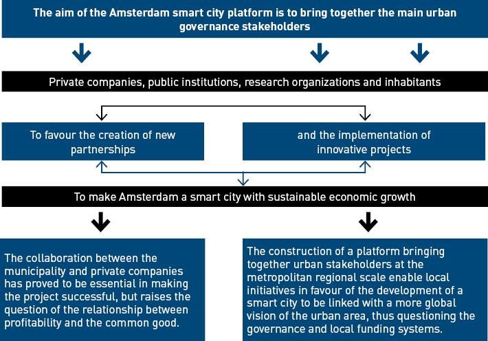
4.2 What are the issues and challenges to effective integration and further improvement? .................................22
      4.3 Does the SDI concept resonate with the private sector, or do they have another view on data
      infrastructures? ........................................................................................................................................................................................................................................22
      4.4 How do you see the evolution of public sector Spatial Data Infrastructure? .................................................................23
      4.5 What are the approaches to stimulate co-innovation for SDI? ....................................................................................................23
      4.6 How do you see the role of INSPIRE? ....................................................................................................................................................................24
5 Partnership and Collaboration for Location Services and Solutions .....................................................................................................25
      5.1 What are industry’s views on the effectiveness of the current state of collaboration between the
      public and private sector in Europe? ....................................................................................................................................................................................26
      5.2 Is there a need for more robust public-private collaboration? .....................................................................................................27
      5.3 What are the specific areas where the private sector can contribute? ................................................................................27
      5.4 How can the location data and technology sector work more closely and more effectively with the
      public sector in Europe? ...................................................................................................................................................................................................................27
      5.5 What are the industry’s views on a single market for data and its impact on collaboration? ......................28
      5.6 What could be the most beneficial models of co-innovation?......................................................................................................28
      5.7 What are the benefits observed and expected from collaboration between the public and private
      sector? ...............................................................................................................................................................................................................................................................30
      5.8 What are the challenges foreseen in the collaboration and partnership and the proposed solutions? 30
      5.9 What are the key lessons on collaboration from location data and technology perspective? .......................31
6 Case Studies on Use of Location Data ..............................................................................................................................................................................33
      6.1 Case Study 1: Amsterdam Smart City ..................................................................................................................................................................33
              6.1.1                 Overview .........................................................................................................................................................................................................................33
              6.1.2                 Projects ............................................................................................................................................................................................................................34
              6.1.3                 Benefits............................................................................................................................................................................................................................36
              6.1.4                 Challenges.....................................................................................................................................................................................................................37
      6.2 Case Study 1: Port of Rotterdam – Dynamic Digital Twin ................................................................................................................37
              6.2.1                 Overview .........................................................................................................................................................................................................................37
              6.2.2                 Project ...............................................................................................................................................................................................................................38
              6.2.3                 Benefits............................................................................................................................................................................................................................38
              6.2.4                 Challenges.....................................................................................................................................................................................................................39
      6.3 Case Study 3: SCALGO – Location enabled applications based on open government data.............................39
              6.3.1                 Overview .........................................................................................................................................................................................................................39
              6.3.2                 Products ..........................................................................................................................................................................................................................40
              6.3.3                 Benefits............................................................................................................................................................................................................................41
              6.3.4                 Challenges.....................................................................................................................................................................................................................41
      6.4 Case Study 4: Virtual Singapore – 3D empowered smart nation ..............................................................................................41
              6.4.1                 Overview .........................................................................................................................................................................................................................41
              6.4.2                 Projects ............................................................................................................................................................................................................................42
              6.4.3                 Benefits............................................................................................................................................................................................................................43

                                                                                                                                     ii
6.4.4                 Challenges.....................................................................................................................................................................................................................43
Annexes ....................................................................................................................................................................................................................................................................45
        Annex 1. List of organization interviewed ......................................................................................................................................................................45
        Annex 2. Company Profile..............................................................................................................................................................................................................48
References .............................................................................................................................................................................................................................................................71
List of abbreviations and definitions ...........................................................................................................................................................................................73
List of figures .....................................................................................................................................................................................................................................................75
List of tables ........................................................................................................................................................................................................................................................76

                                                                                                                                     iii
Author

Anamika DAS
Geospatial Media and Communications BV
Donauweg 10
1043 AJ Amsterdam
Netherlands
Anamika@geospatialmedia.net

Editor

Vlado CETL
European Commission
Joint Research Centre
Directorate B - Growth and Innovation
Unit B6 – Digital Economy
Via E. Fermi 2749, TP 263
I-21027 Ispra (VA), Italy
vlado.cetl@ec.europa.eu

                                         1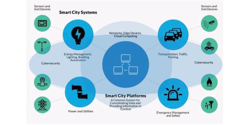
Abstract
The purpose of this study is to contribute to the ‘Businesses’ action plan defined in the European Location
Interoperability Solutions for e-Government (ELISE) Policy Note on the state of play of location data for policy
and digital public services in Europe. It also builds on the ELISE work already undertaken on the topic of
geospatial co-innovation presented at the INSPIRE 2020 Online Conference workshop: Co-innovation with
public-private sector data ecosystems. The study assessed the potential collaborations and prospective
partnerships between European public administrations and location industry that may further elevate
effective use of location information and intelligence for policy and digital public services in the region.

                                                       2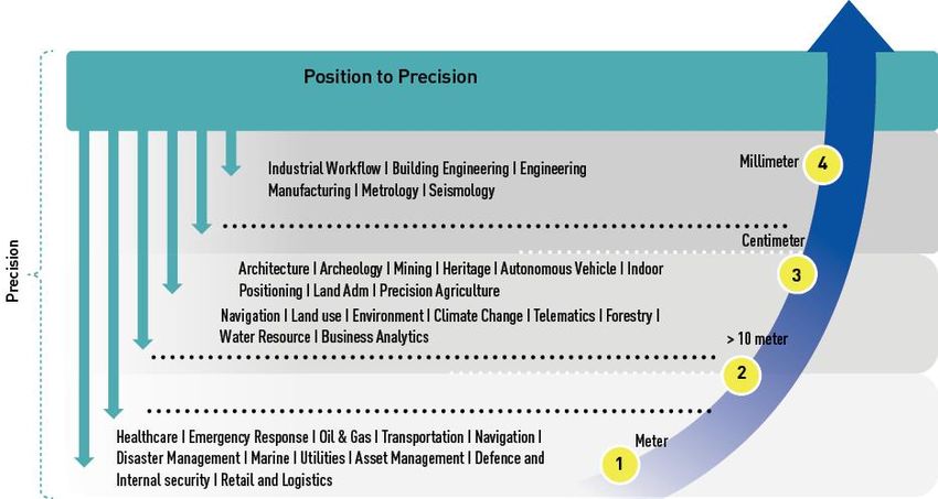
1    Executive Summary
In recent years, the wide diffusion of technologies such as cloud computing, Internet of Things (IoT), and
4G/5G, has enabled many cities and local communities to transform into hubs of digital transformation –
realising unprecedented levels of safety, resilience, and quality of life.
Adopting openness principles and best-of-breed ICT innovations, such as Artificial Intelligence (AI) and data
analytics, spatial and satellite positioning, digital twins and mobile edge computing, government
transformation is being redirected towards an increasing centrality of users’ needs and requirements and is
no longer considered as stable across time and place but continuously changing depending on location and
contingent status.
These trends are raising the challenge of digital transformation of the EU public sector, requiring a seamless
adaptation of its organisational structures, service models, policy frameworks and governance systems.
For the medium to long term, the establishment of a new digital infrastructure – comparable to public
utilities’ networks, such as energy or water – can be predicted, that acts as the primary interface between
government and citizens and businesses on the move, both within and across the country borders. Like
“network industries” this network of governance stakeholders and their administrative entities, will be so
intertwined with the physical world that separating it from other “traditional” infrastructures will no longer be
possible.
Such evolution is formally acknowledged by the “Join, Boost, Sustain” declaration for upscaling digital
solutions in Europe (JBS), which has been introduced during the Finnish EU Presidency and is now promoted
by a growing number of European cities and a large group of stakeholders, with the active support and
orchestration of the European Commission.
In this context, an unexpected game changer is constituted by the Covid-19 crisis, characterised by a
convergent pattern of national and regional initiatives at the EU level, all aimed at the best possible
compromise between protection of public safety and integrity on the one hand, and the restart and relaunch
of socio-economic activities on the other.
Most of these initiatives directly impacted the delivery mode of public services to businesses and citizens, and
some of them utilise methods and tools that are somehow related to user geolocalisation and behaviour
tracking.

1.1 Purpose, Objectives and Scope of Study
A progressive and enabling policy is key to creating significant economic and societal benefits that accompany
the use of location intelligence solutions in varied applications. While SDIs and policy frameworks are
primarily the responsibility of the public sector; the private sector which holds a large amount of spatial data
relevant for government bears a significant management responsibility and therefore plays an important role
in building the policy framework.
To bridge the gap in understanding and implementation of location intelligence solutions, it is necessary for
the public sector to proactively engage with the private sector in various spheres of the location intelligence
domain for defining its value proposition for the economy and society.
At present, there needs to be greater collaboration toward strengthening integrated (spatial and non-spatial)
data spaces and policy frameworks at national, regional, and global levels serving larger development goals
and governance through mutual understanding and cooperation. The European public administrations can
benefit from more effective partnerships with the location intelligence industry and with other private sector
companies developing products with a heavy reliance on location data.
Private sector location data can be combined with public sector data via a well-defined co-innovation model.
The European data ecosystems, including the evolution of SDI models and (2D, 3D and 4D) city models can be
designed in a more collaborative way if private sector requirements are also considered. This way, the private
sector companies operating in multiple countries in Europe can benefit from harmonised public sector location
data and services.
The purpose of this study is to contribute to the ‘Businesses’ action plan defined in the ELISE Policy Note on
the state of play of location data for policy and digital public services in Europe. The study assessed the
potential collaborations and prospective partnerships between European public administrations and location

                                                       3
industry that may further elevate effective use of location information and intelligence for policy and digital
public services in the region.
The objectives of this study are:
— To develop an overview of location data and technology and application trends in the industry.
— To capture private sector views on collaboration with the public sector on location data and location
  intelligence under the umbrella of European Data Spaces – including national and local contexts and
  areas for improvement.
— To capture industry’s views on what they would like to see emerge from the Open Data Directive and
  European Data Strategy and how they can contribute to support the aims of these policies.
— To explore the potential collaborations and partnerships between European public administrations and the
  location data and technology sector.

1.2 Methodology
To achieve the objective of the study two-step approach was taken:
— Direct engagement with relevant industry stakeholders for inputs.
— Secondary research based on online articles, blogs, press releases and existing reports on the location
  data and technology ecosystem, its current landscape, trends, best practices, and existing public-private
  partnerships.

1.3 Structure of the Report
This final report is structured as follows:
Chapter 1 provides the trends in location Industry. It elaborates the trends that are creating, organizing, and
propelling development in location technologies creating value of location data or information in several
sectors.
Chapter 2 explains the views of private sector on what they would like to see emerge from the Open Data
Directive and European Data Strategy and how they can contribute to support the aims of these policies.
Chapter 3 details the evolution of SDI, areas of improvement, approach to co-innovation, and the role of
INSPIRE.
Chapter 4 elaborates specific areas where the private sector can contribute along with the value proposition
for their contribution and few models of co-innovation.
Chapter 5 highlights 4 case studies covering different aspects of collaboration.
— Amsterdam Smart City highlights the public private partnership for development of the smart city
  platform.
— Port of Rotterdam underlines the current state of collaboration for location data and knowledge for
  Digital Twin
— SCALGO demonstrates how open location data contributes to the social and economic well-being of the
  nation
— An international case study “Virtual Singapore program” highlights collaboration for 3D model at national
  level.
In addition, the document includes the following annexes:
Annex 1: List of organizations interviewed
Annex 2: Profile of the key companies in location ecosystem

                                                       4
2 Location Industry Trends
2.1 Location Industry and Digital Economy
For evidence-based decision making, location technology is a country’s “digital currency.” It is a vital part of
the nation’s infrastructure and information economy, as it serves as a roadmap for what happens when and
where. It integrates a broad range of government programmes that support economic growth, environmental
protection, national security, social development, and national prosperity.
The term “location technology” refers to a wide variety of modern methods for mapping the earth’s surface. It
uses intelligence and analytics to provide a context for the collected spatial data. As a result, any technology
that allows for the development, management, analysis, and visualisation of location data is known as
location technology.
With the advancement of information technology, location data has become a popular language for the
world’s 7+ billion people. The Fourth Industrial Revolution has made location knowledge commonplace and an
integral part of our everyday lives. Over the last few years, it has integrated with the broader Information
Technology and Engineering processes. This digital disruption is merging human, physical and digital
environments, leading to unprecedented societal changes and radically disrupting the location industry that
has opened to more significant market drivers, creating new opportunities while weathering through market
forces and consumer behaviour.
2.2 Location Technology Ecosystem
The location technology ecosystem, as shown in Figure 1, is a multidimensional entity with multiple
interactive components. From the technology point of view, it includes:
— Spatial Analytics: a system that is designed to capture, store, manipulate, analyse, and interpret data
relationships, patterns, and trends.
— Global Navigation Satellite System (GNSS) & Positioning: consists of GNSS upstream and downstream
markets, the surveying market and the indoor positioning market.
— Earth Observation: includes technologies like satellites in space, aerial photography (manned as well as
unmanned flying vehicles).
— 3D Scanning: comprises of Laser, LiDAR, Radar and Point Cloud – non-contact technologies that can
digitally capture the shape of physical objects
Figure 1. Location technology ecosystem
Source: Geospatial World.
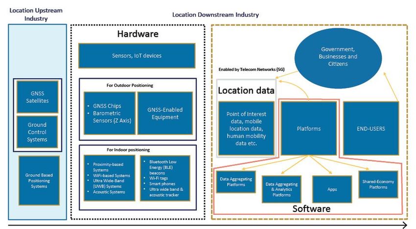
The value chain of the location industry can be divided into upstream and downstream, as shown in Figure 2.
The downstream of location industry spans from component manufacturer to hardware and software with
data/content as a key component for providing data analytics and solutions. The data is processed and stored
on a platform by the data providers. Service and solution providers also play an eminent role in making the
data available to the end user.
5Figure 2. Value-chain of location industry
Source: Geospatial World.
2.3 Location Data Key to Fourth Industrial Revolution
Various government as well as private initiatives are seen to promote a data-based industrial revolution in the
world. Cloud, mobile, internet, and Internet of Things (IoT) technologies have resulted in an avalanche of data,
necessitating the use of data analytics. Their active use in business and everyday life would mean that “data”
would rule the world, and this is what we refer to as the Data-based Industrial Revolution. More than 80% of
all the available data has a spatial component, which is a foundational component of the data infrastructure,
as demonstrated in Figure 3. The availability of such large amounts of data has given rise to the Data
Economy, which is thriving on analytics and value derived from the varied data sources. A converged Digital
Infrastructure underpins this data economy, ensuring continuous data storage and sharing via communication
systems. Any data or system requires a crucial ‘where’ or position component, which is provided by location
data.
6Figure 3. Location data - foundational component of data economy
Source: Adapted from IBM and Geospatial World.
2.4 Industry Trends
Following are the trends that are creating, organizing, and propelling development in location technologies:
72.4.1 Integrating Workflow
Location technology has evolved from being a highly compartmentalized industry towards convergence,
collaboration, and integration of constituent technologies as its cornerstone. This accelerated end-to-end geo-
enabled workflows across several vertical industries. The two industries that are currently witnessing large
use of multiple location technologies, mostly in integrated forms, are Architecture, Engineering & Construction
(AEC) and the Business Intelligence & Location Intelligence, and Figure 4 demonstrates the application areas
of location technology within these industries. Construction companies who have taken on design, build,
operate and/or maintain projects have found, for full life-cycle construction projects an approach that
combines BIM + geospatial significantly improves outcomes. Major construction firms like EllisDon, Parsons
Brinckerhoff, Atkins Global, Arcadis, BAM, AECOM etc. have realized that BIM + geospatial integration provide
greater value for full lifecycle projects.
Figure 4. Workflow integration of location industry
Source: Adapted from Geospatial World.
2.4.2 Miniaturization of Sensors
The increase in number of sensors everywhere, from space to smartphone to cars around us will lead to an
explosion in the volume of location data. Miniaturized and lower-cost sensors have led to an increase in
information of what, when, where, and popularized the technology. Starting with smartphones, the technology
has now progressed to the fields of LiDAR and Earth Observation, with advancements in LIDAR sensors for
autonomous vehicles and a handheld imaging backpack. The satellite industry has been revolutionised by the
launch of breadbox-sized and even smaller satellites, which have the advantages of improved efficiency,
enhanced capability, and reduced costs. The miniaturization is making location a default in all walks of life.
With the advanced imaging systems in the mobile phone, it has the potential for indoor and close-range 3D
mapping with required software for 3D modelling.
2.4.3 Expanding Wireless and Web Networks
Wider and faster wireless and web networks are helping the end users to meet the increasing demand for
better data transmission and location data delivery. This paves the way for governments and users around
the world to exchange and use spatiotemporal data more widely, including for real-time applications.
82.4.4 Advancement of Mobile Location Sensor Platforms (High Altitude Platform
Systems (HAPS) and Unmanned Aerial Vehicles (UAV)
A new direction for data collection has emerged thanks to advances in Unmanned Aerial Vehicles (UAVs) and
High-Altitude Platform Stations (HAPS). These technologies increase the capacity to collect high and very high-
resolution imagery in near real time for local monitoring applications, addressing some of the demand for
immediate access to high-quality EO data.
2.4.5 The “Real-Time” and “Knowledge on Demand” Revolution
Knowledge-on-demand will be enabled by the continued development of AI/ML applications and modelling.
While real-time spatiotemporal data is now almost universally created, and its applications in research and
commerce are widespread and rapidly expanding, the ability to continuously create and interact with this data
in real time is a relatively new phenomenon. This breakthrough is acting as a catalyst for progress in the field
of location. This immediate interaction between space and time remains today the underlying process that is
generating myriad mobile location apps in governments, businesses, and society.
2.4.6 Advances in Computing Capacity and Data Democratization
High-performance computing, cloud computing services and networks are providing governments and other
sectors with channels through which they can retrieve as well as contribute to the expanding location data,
services, and tools with more ease.
Big data and data science play a pivotal role in data democratization. Smart buildings, self-driving vehicles,
and crowd sourced data are examples of location-based technologies that capture useful data around the
clock. Big data can be used to build new location databases or update existing ones in real time, bringing
benefits to a variety of industries such as planning, construction, utilities, and transportation.
By adopting the latest advances in the fields of machine learning, artificial intelligence and deep learning will
shorten the time needed to mine data and transform it into knowledge. It is the way to grow the industry.
2.4.7 Mapping-as-services
Cloud technology advancements have opened new doors and revealed new business models. Mapping as a
Service is one such business model. On-demand and based on consumer requirements, companies are
offering data, high-resolution satellite imagery and maps for every place in the world. This has completely
transformed location industry.
2.4.8 GeoAI
In the latest age of automation, artificial intelligence (AI), deep learning (DL), and spatial artificial intelligence
(GeoAI) are the most recent additions. When combined with location, these emerging innovations are leading
the technology environment toward exciting capabilities. GeoAI is the product of combining artificial
intelligence (AI) and the geographic information systems (GIS).
GeoAI’s growth has opened up unprecedented opportunities for both the public and private sectors. It has the
potential to be a critical component in contributing to global economic growth and social change, as well as
opening previously unattainable opportunities.
2.4.9 Predictive Analytics
Predictive analytics is an amalgamation of statistical techniques derived from cutting-edge technologies such
data mining, predictive modelling, and machine learning to predict about future outcomes. It has the ability to
generate insights about the future with a significant amount of precision. An organization can now
consistently forecast trends and behaviours using previous and present data as an input to predictive
analytics tools and models.
92.5 Application trends
The growing demand for location solutions from
various industries to combine their workflow
management with location data has rendered
location data an indispensable tool for obtaining
the necessary precision (Figure 5). The
users/developers rely on mapping platforms and
location data for developing autonomous driving
and connected cars, developing food delivery apps,
analysis of fleet management, etc.
It is difficult to deny the value of location data or
information in several sectors, with benefits
accruing to organisations in a broad range of
application areas.
Granular location data can provide exceptional Figure 5. Application Areas of location solutions
insights regarding the physical world, and this has
been realised by various governments and businesses, which are now focusing on location data and its impact
across the globe. In today’s interconnected world, the realistic uses of position data are nearly limitless. A
diverse range of solutions can be produced by combining different data sources, in-situ data, and location
data.
In the present day, the complexity of the knowledge ecosystem has made partnerships and collaborations a
necessary component as no single unit can generate end-to-end solutions without being technically
dependent on some other sector.
2.5.1 Digital Twin
Building a virtual model of a physical asset allows for scenario preparation and testing against data collected
by today’s growing number of sensors. Digital twins are within reach of most industries, thanks to Internet of
Things (IoT), Internet of Behaviour (IoB), edge computing, and new devices being created and operationalized
for all forms of data collection. With the incorporation of location data and links to the models, it is possible
to understand not just where a critical asset is located, but also when the data was collected and what
circumstances occurred at the time and location. To fully develop a location-aware digital twin, it must be
refined by analysing the volume of data collected and that data must be incorporated through location
connectivity. The development and use of such digital twins are transformative. Estonia's nation-wide digital
twin initiated in 2018 has been developed in cooperation between public and private sector. It includes
buildings, roads, and other transportation infrastructure such as rail and airports, and underground utility
networks. The first big step in the creation of a 3D model of Estonia, is bringing construction to the 21st
century, by converting data to 3D format, connecting to metadata, and adopting a BIM-based building permit
process. These initiatives are expected to speed up permitting and raise level of compliance thereby improving
construction productivity by a factor of three. The digital twin gathers data and visualizes real-life situations
so accurately that, in the future, the country will be able to test and work on constructions projects in virtual
reality, before putting them into action in real life. Going forward, the applicability of the national digital twin
can be expanded to diverse areas including product development, spatial planning, surveillance, remote
control, maintenance etc.
2.5.2 Position to Precision
The growing demand for location-based solutions from various industries to combine their workflow
management with location data has rendered location data an even more important tool for obtaining the
necessary precision. Seismology, Metrology, Manufacturing, Engineering, Architecture, Indoor Positioning,
Building Information, Archaeology, and Land Administration are some of the leading user segments utilizing
location technology. These application areas require precision in location of a data at less than a meter (even
millimetre accuracy in some cases), which emphasizes on the need of location technologies to capture
satellite data for application purposes. The precision requirements for location data in application areas
across various sectors are shown in Figure 6. In the current scenario, the use of location technology is not only
restricted to the conventional sectors like defence and internal security, urban development, infrastructure,
10disaster management. Location analytics is being used in varied areas, that may or may not drive the location
market directly but surely adds to the democratization of the sector.
Figure 6: Application area-specific precision requirements
Source: Adapted from Geospatial World.
2.5.3 Autonomous Revolution
With the increase in popularity and demand of self-driving cars, the involvement of car manufacturers in
autonomous driving is more active. Self-driving cars use artificial intelligence and location data to understand
infrastructure specifications and conditions. The most important part of self-driving vehicles is geodata and
this data is gathered by using multiple sensors. These sensors are being used for mapping, localization and
for avoiding obstacles. It is predicted that the location industry will hold a significant market share of the
services and technologies that will be used to support and navigate the smart revolution. In Netherlands, the
Cabinet has approved a change in the law to allow large-scale testing with self-driving cars and lorries on
public roads. There are three major ongoing autonomous bus trials across Europe: In Helsinki, Finland, by
Sohjoa; in Sion, Switzerland, by Postbus; and in Wageningen, Netherlands, by WePods.
2.5.4 Smart Cities and Urban Platform
Smart cities and intelligent transportation systems are some of the concepts which are growing rapidly. The
digital trends like big data, machine learning, digital twins are significant contributors to this growth.
Additionally, the utilization of IoT for cloud data storage and processing in near-real time facilitate this wider
expansion of location technologies. The origin of this new and dynamic ecosystem has helped in technical
transition of applications like traffic management, public health, budgeting, environment, urban heat islands,
urban mapping, etc.
11Figure 7: Smart City Platforms and Applications
Source: ARC Advisory
A smart city is a system of systems that includes smart lighting systems, building automation systems,
emergency management systems, security and access control systems, intelligent grids, renewable power,
water treatment and supply, transportation, and more. The Smart City Platform unifies these systems for
users and provides a common system for data management, data visualization and optimization of overall
city operations, as shown in Figure 7. Some of the different existing solutions created to support smart city-
oriented services are shown in Figure 8.
Figure 8: Existing solutions to support Smart City-oriented services
2.6 Benefits of Location Technologies
Location data is one of the most essential components to study any sectoral market today. Location
technologies help government and businesses improve their quality, capacity, efficiency, and productivity
(Figure 9). It is not only useful for increasing awareness but also for discovering potential customers, planning
and management.
12Figure 9: Benefits of location technology
In addition to detecting location, this technology can also give organizations and citizens real-time
information about weather and traffic to identify the best route or potential time to visit that location.
Location technologies benefit consumers in secured transaction and fraud prevention. For example, it can
verify a customer’s location through their phone and match that location with the credit card being used for
the transaction to determine if the credit card is being used fraudulently or not. The location data is however
needed to be handled with complete authorization and authentication to prevent any security breach.
From a small-scale business to an organization, location- based networking data is one of the most essential
components of any running business/industry. The data can be effectively leveraged for publicity of a
business location, the real-time monitoring of customer traffic, reviewing customer comments, offering
rewards, monitoring success rate of the business for various outlets, etc. With the evolving technology to 4IR,
the true potential of location technology is yet to be uncovered and utilized.
133 Open Data Directives and European Data Strategy
Spatial data has become a key asset for the economy and our societies. Data is leading to innovations in
technology, competitiveness, job creation and development of new tools and new skills. From the standpoint
of Europe’s data landscape, the recently announced Open Data Directive and the European Data Strategy is a
pioneer and innovative approach towards building an attractive, secure, and dynamic European data economy
benefiting the overall economy and society.
European Data Strategy establishes an ambitious agenda that aims to leverage the favourable technological
and political context, and empowers EU citizens, businesses and the public authorities through a data-agile
approach which is in line with European values and reflects the needs of a multitude of actors.
The Open Data Directive aims at exploitation of the potential of public sector information at its maximum for
the European economy and society. It also encourages the access to and re-use of public and publicly funded
data. As per the Directive the ‘high-value dataset’s has the potential to generate significant socio-economic or
environmental benefits and innovative services which will benefit many businesses and users by encouraging
innovation, creating additional opportunities, boosting customer intelligence and in delivering services leading
to generating revenues. A few cases of companies delivering services using open data are stated in Table 1:
Table 1. Private companies delivering services using open data
Company Service
City mapper City mapper, the start-up uses information made public by TfL for its navigational
app which has now been valued at around £250 million.
GeoLytix GeoLytix offers location consultancy services to smaller companies that don't have
the resources to build their own datasets.
Parkopedia Parkopedia fuses location and live data from local authorities to help drivers
identify free car parking spaces.
Geomanagement Geomanagement offers various services based on the analysis of location data
helping clients to find solutions for their specific problem.
Duedil Duedil is a business information provider that gives free access to governance and
financial information for every company in UK and Ireland and combines this with
data from online sources, APIs, social network and more.
Source: City mapper, GeoLytix, Parkopedia, Geomanagement, Duedil.
The value chain of open data ecosystem has two main constituents - government and businesses who deliver
services demanded by users (government or enterprise), and citizens (Figure 10).
14Figure 10: Value Chain of Open Data Ecosystem
Source: Creating Value through Open Data
In view of the involvement of private sector in adding value to the Open Data at different steps along the
value chain it is pertinent to understand what the private sector would like to see emerge from the Open Data
Directive and European Data Strategy, and how they can contribute to support the aims of these policies,
Interactions were conducted with private sector organizations, and they were asked to present their view on
the following questions:
— What you would like to see emerge from the Open Data Directive and European Data Strategy?
— How do you see your contribution?
— What benefits can the private stakeholders reap from the adoption of these initiatives?
— What are the challenges in the effective implementation of the initiative?
— What are the measures to be taken to overcome the challenges and make the initiative successful?
— How do you think the creation of a single market for data from public bodies, businesses, and citizens
under the European Data Space initiative impact the collaboration in location data?
The table 2 below lists the companies interviewed for the study. The companies are presented more in-depth
in Annex 1: List of organizations interviewed.
Table 2. List of companies interviewed.
Organisation name (1) Website Country
Google www.google.com UK
Catapult https://sa.catapult.org.uk UK
Geolytix https://geolytix.com UK
Esri www.esri.com The Netherlands
Space4good www.space4good.com The Netherlands
Geodan www.geodan.com The Netherlands
Fugro www.fugro.com The Netherlands
15Avia-GIS www.avia-gis.com Belgium
Locatus https://locatus.com/en Belgium
Proxyz www.pozyx.io Belgium
Geograma www.geograma.com/en/ Spain
CloudEO www.cloudeo.group Germany
Oracle www.oracle.com Germany
Data Appeal Company www.datappeal.io Italy
()
1
Apart from the above-mentioned companies four more interactions were done which are under non-
disclosure.
The current chapter elaborates the views from the private sector on the Open Data Directive and the
European Data Strategy. Their views on “SDI and areas of improvement” and “Partnership and Collaboration”
are elaborated in chapter 4 and 5 respectively.
3.1 What would you like to see emerge from the Open Data Directive and
European Data Strategy?
An unfiltered view was provided on their expectation from the Open Data Directive and Europe Data Strategy.
Majority of them emphasized that there is a large amount of data behind closed doors. They would like to
have access to those datasets. In many regions, the data generated by mapping agencies are freely
accessible to government entities, whereas private entities have to pay a fee to access the openly available
data. The datasets created for government purposes by using taxpayers’ money should be made openly
available with fewest restrictions whether or not they add additional value to third parties.
Even in cases where metadata is provided, there are significant hurdles in accessing the data made available.
The open availability of data doesn’t guarantee ease of use, as in many cases they aren’t in usable formats,
and there isn’t documentation on the methodology used to acquire data (like concepts, fields, values). The
Open Data Directive and the European Data Strategy are expected to break down these barriers and make
data access and use easier for private entities. The need is to have a stronger description of the form and
structure for the release of Open Data.
With data from diverse sources (private and public) integrated as European data strategy is envisaged, a
trusted framework for sharing data needs to be developed, and clarity on the structure, authenticity, and
integrity of the data needs to be ensured, to make optimal use of the shared data. In addition, clarity should
also be ensured regarding the terms of availability of different datasets across EU, and the expected benefits
and value generation. To set a positive regulatory framework, the public governance authorities need to
understand the areas where open location data will be of use in the future, and make its use mandatory,
thereby making it more goal-oriented and driving adoption.
A measurement of the return on investment from open data sharing and data strategy, demonstrated through
concrete examples needs to be done, to develop clarity and propel behavioural change. The private sector
which is already set in its ways of delivering services and solutions to its users, needs clear communication
regarding the value proposition of standardized approaches to do things differently. A service-based
integration approach needs to be followed for data access, through development of open services with the
integration of data into decision-ready information products, thereby opening it up to decision-makers and
citizens. Such a cooperative approach for data can create significant value to all stakeholders involved. In
addition, major investments need to be made in technology and infrastructure to enhance data access and
use, while giving individuals, as well as public and private organizations full control over the data they
generate.
Awareness around Open Data and Data Strategy is the need of the hour at both the ends i.e., data provider
and user. Currently the awareness is not at the optimum level. Greater levels of awareness will not only lead
16to higher use of open data benefitting the society at large, including the private and civic sector, but will also
lead to a higher political pressure for the public sector to provide high quality Data.
3.2 How do you see your contribution?
Diversification and increased amount of information available from collaboration and varied sources of data
will allow to uncover new insights. The industry is looking forward to contributing to enhancing the open data
ecosystem through identification of new sources of data and development of new products, by collaborating
with stakeholders through innovative business models.
With the European Data Strategy and Open Data Directive the industry is looking to contribute by developing
platform services for sharing open data through open catalogues. The private sector has established links
with developers that can be utilized in making the open datasets easily available through the platforms used
to build apps online or on mobile devices. The private sector can thus be a channel to get to the developers,
and ultimately to the citizens.
The industry will also bring in their expertise and experience of standardizing data formats. With the
government in the driving seat for making better governance decisions, the industry can align their solutions
to match their vision.
The private sector can work as an amplifier, bringing out solutions based on these datasets, and making them
accessible to broader communities. The private sector can also provide their expertise in the development of
enhanced and accurate forecasts based on data from diverse sources through advanced data analytics,
thereby enabling better decision-making and reducing inefficiencies of day-to-day operations. In addition,
some of the data in the custody of the private sector can be made open as part of their corporate social
responsibility agenda.
3.3 What benefits can the private stakeholders reap from the adoption of these
initiatives?
These initiatives will bring in data harmonization which will have a huge impact in the generation of new
services, value-added products, and applications to increase efficiency, and increased coordination among
public institutions, which will in turn lead to economic development.
The quality and consistency of the data, a critical factor for successful operation of the businesses, can be
ensured through the open data initiatives. These initiatives will bring in consistency for Open Data, both in
terms of content and frequency which will enable transformation of data into knowledge for solving business
and societal challenges.
These initiatives will develop an environment of collaborations for improving situational and causal analysis.
Sharing, linking, and combining of data across sectoral and institutional boundaries helps in unlocking new
insights which can help government officials to identify and understand governance problems better, and
address them through focused evidence-based policies.
Aggregation of data from diverse sources through data-sharing initiatives play a vital role in building more
robust, accurate, and responsive Artificial Intelligence models. The development of AI models and creation of
new insights will ultimately lead to benefits across the value chain and provision of better services to citizens.
In addition to the wider benefits, open data will also lead to cost savings (through the re-use of data available
in the public domain) and increased revenue (through services or solutions transforming raw data into
actionable insights) for the private industry.
3.4 What are the challenges in the effective implementation of the initiative?
With the opening of large amount of data through open data initiatives, it is imperative upon the public
authorities to make sure that the open data is available and accessible to both private and public sector for
development of solutions and services for improved decision-making and policy development.
The heterogeneity of the data in terms of format and structure across numerous portals, interfaces and
languages can hinder re-users from automation of collection and processing of data. With the availability of
data from diverse sources, maintaining the quality of data (eg: data not being granular enough for
processing) becomes a significant challenge. The frequency of update of diverse data also becomes a
challenge for organizations which rely on periodically updated data for the functions.
17You can also read


