SUGGESTION 9 5 ANDY MCCLUSKY - AUSTRALIAN ELECTORAL COMMISSION
←
→
Page content transcription
If your browser does not render page correctly, please read the page content below
Suggestion 95

 Andy McClusky
     29 pages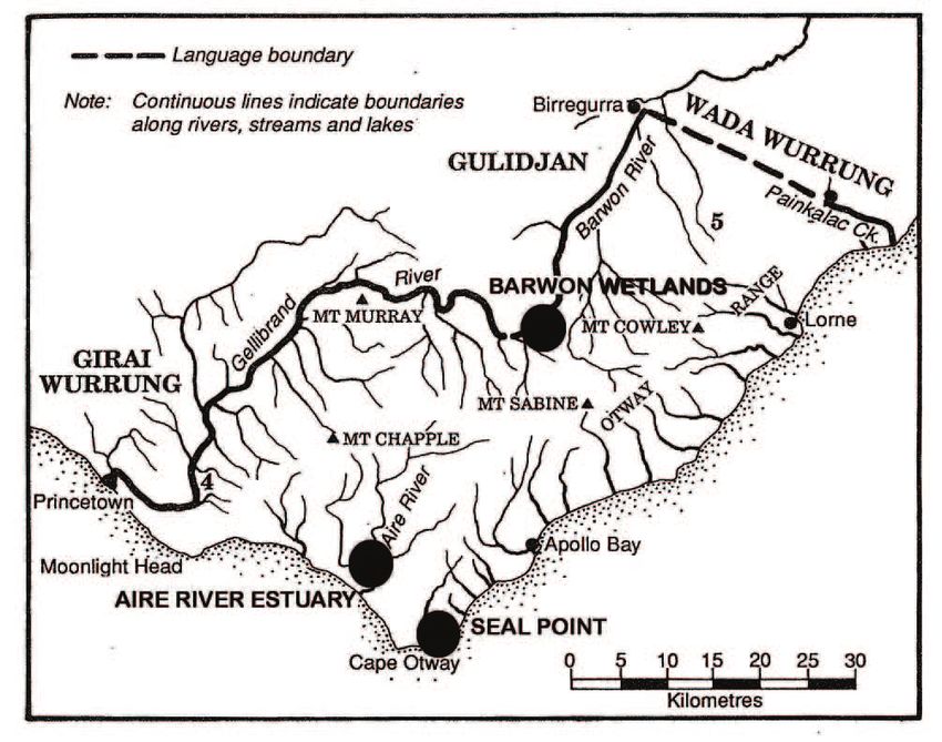
"Barrwang", meaning Magpie, derivative meaning Barwon. Wathawurrung

"Connewarre" or "Kunuwarra" meaning Black Swan. Wathawurrung

Seat 2 Corangamite subdivision location - South West from Coastline. (New
growth population corridor)
"Pirt Koorrook" meaning Strong Woman, Tall Gumtree. Gadubanud, Gulidjan.
Giral Wurrung

"Gadubanud" meaning King Parrot People, King Parrot Language. Gadubanud,
Gulidjan, Giral Wurung

The Gadubanud people occupied the rainforest plateau and rugged coastline of
Cape Otway in Western Victoria covering the present towns along the Surf coast
from Painkalac Creek Fairhaven, Lorne, Apollo Bay to Cape Otway to Princetown
along the Gellibrand and Barwon River into the hinterland are the likely territorial
borders of the neighboring tribes of the Gulidjan, Watherong, and the Girai (Kirrae)
Wurrung people.

I strongly believe the new 39th federal seat of Victoria within the existing name of
the federal seat of Corangamite region, should be a traditional aboriginal name to
honour and acknowledge our First Nations people's tribes and cultures of
the region that connects us all to Country.

Andy McClusky

Corangamite, Lorne

I acknowledge the Gadubanud, Gulidjan, Girai Wurrung people, Eastern Marr and
Wathaurong Nations as the traditional custodians within the present federal seat of
"Corangamite" region. I pay my respects to their Ancestors and Elders, past,
present and emerging. I recognise and respect their unique cultural heritage,
beliefs and relationship to their traditional lands, which continue to be important to
them today and into the future.

---------------------------------------------------------------------

Historically 05/06/2018

Re Distribution- Augmented Electoral Commission Hearing - Winchelsea Victoria
OB126 05/06/2018 10am

Good morning my name is Andy McClusky from Lorne Otway Region

Dear Jim Chairperson, Augmental Commission panel members and the people of
Australia.

Firstly I would like to acknowledge the traditional custodians of this land, all the
Women’s Day we would like to introduce you
                          to Violet Edna Arnold, nee Baulch, is known
                          otwaylifemagazine.wordpress.com
                          locally as Aunty Edna.

Virus-free. www.avg.com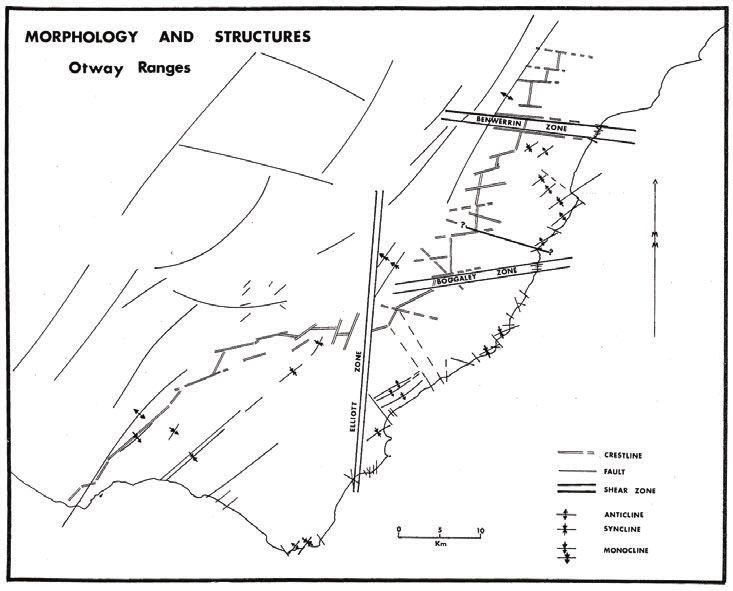
Gadubanud society in the Otway Ranges,
        Victoria: an environmental history
                                        Lawrence Niewójt

     The Otway Peninsula is probably the least known Victorian tribal area, as 19th
     century records are virtually silent concerning its aboriginal inhabitants.

                                                           — DJ Mulvaney, 1961

Nearly 50 years since Mulvaney’s archaeological research at Aire River, local
historians have ventured little beyond cursory statements regarding the
Gadubanud people of the Otway region. Though scholars acknowledge the
long-term Aboriginal presence in the area, the dearth of documentary sources
has deterred sustained inquiry into the history, economy and enduring relics of
pre-contact Aboriginal society. While past attempts at ‘ethnohistory’ presented
surveys of what little information could be gleaned from official papers, to
date there has been no attempt to move beyond these brief (but informative)
summaries.1 Circumventing the perceived roadblock posed by an exhausted
documentary record, we can gain a more nuanced understanding of Aboriginal
presence in the Otway region by broadening the range of research questions
we are prepared to investigate and employing an expanded set of evidentiary
materials. A synthesis of the diverse lines of inquiry pursued by archaeologists,
earth scientists, ecologists, historians and geographers enables us to gauge
the scale and magnitude of past Aboriginal interventions in the landscape.
Approaching old sources with a fresh eye for detail and analysis, we can
reconstruct the cultural landscape created by the Gadubanud people prior to
their disastrous encounter with Europeans in the late 1840s.

   The Gadubanud people, residing at various nodes of settlement throughout
the Otway region, adapted the land and altered the distribution of ecological
communities to best serve their needs. The risks inherent in a subsistence economy
were contained and spread geographically using a sophisticated system of land
management. Furthermore, a pattern of semi-nomadic movements linked inland,
estuarine and coastal occupation sites that were known for their high food yields
and provided dietary variety throughout the year. The reconstruction of the
Gadubanud’s settlement and land use patterns in the Otway region of Victoria
– despite the absence of a detailed documentary record – validates Robin and

1   Scarlett 1977: 1–5; Stuart 1981: 79–88; Clark 1990.
                                                                                      175
ABORIGINAL HISTORY 2009 VOL 33
Griffiths’ declaration that ‘much Aboriginal history is environmental history’
and emphasises the potential utility of interdisciplinary approaches in this area
of research.2
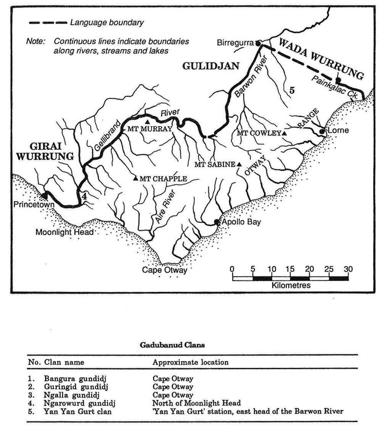
Fig 1. The traditional territory of the Gadubanud people and the approximate
location of various clans
Source: Clark 1990: 189. Reproduced with the permission of Professor Ian D Clark.
2 Robin and Griffiths 2004: 456.
176Gadubanud society in the Otway Ranges, Victoria
The Gadubanud people in the written record
Hemmed in by a rising ocean that stabilised about 7000 years ago, the uplifted
sedimentary rocks of the Otway Range run from north-east to south-west at an
elevation of about 500 metres above the sea. A few isolated peaks reach up to
675 metres, and at many points along this coastline bare mountains and tree-
clad ridges plummet dramatically into the sea.3 In the north, the narrow belt of
foothills merge with the undulating volcanic plain that is the definitive feature
of Victoria’s Western District. Littoral plains are found only at Apollo Bay and
further west, but even these flat stretches of coastal terrain do not exceed five
kilometres in width. Vegetation within the traditional territory of the Gadubanud
people varies from heath on the sea cliffs, to dunes near the Cape, open forest on
the eastern slope, wet sclerophyll forest in the mountains and tracts of rainforest
along some watercourses and mountain gullies (see Fig 1). Highly productive
ecosystems, such as the wetlands found at the base of the northern foothills (at
the headwaters of the Barwon River) and the numerous river estuaries of the
coastal zone, provided a vast food supply and a range of options regarding the
seasonal sequence, frequency and intensity of harvesting.
Although they were rarely recorded beyond their country, the Gadubanud
maintained complex ties with other Aboriginal groups and were known to
have close linguistic and familial connections with their northern neighbour,
the Gulidjan people of the Lake Colac area.4 They avoided the primitive sheep
stations that rapidly spread across the volcanic plains of the Western District
after 1837, and shunned the company of heavily-armed European settlers. As a
result, comparatively little is known about their social organisation, leadership,
customs, language and traditions. What follows is a brief summary of what the
documents tell us about these people.
The modern name given to these people derives from the work of James
Dawson, who recorded the Cape Otway language group as ‘Katubanuut’ and
claimed that this meant ‘King Parrot language’ in the local dialect.5 These people
were closely associated with the Gulidjan who resided in the vicinity of Lake
Colac, but were considered to be ‘wild blacks’ by both the Wathaurong to the
north-east and the Girai wurrung to the west.6 Their presence was first recorded
by Chief Protector Robinson in 1842 when he met three Gadubanud people at
the mouth of the Hopkins River (near present-day Warrnambool) and received
details of four clans that resided on the western edge of the Otway Ranges: three
lived at the Cape Otway peninsula and one was said to reside north of Moonlight
Head.7 One of these clans was said to belong to Bangurer, which was noted as
the local place-name referring to Cape Otway.8 Later that year, an unconfirmed
report blamed the Gadubanud for the removal of food and blankets from an
3 Gill 1978: 67–75.
4 Le Griffon 2006.
5 Dawson 1881: 2.
6 Addis cited in Clark 1995: 119.
7 Clark 1990: 190–191.
8 Robinson cited in Clark 1990: 190.
177ABORIGINAL HISTORY 2009 VOL 33
outstation, and in 1844 they were suspected of killing ‘a white teenage boy’.9 In
1853, a letter from George Armytage to Superintendent La Trobe identified a fifth
clan associated with the Gadubanud people. The ‘Yan Yan Gurt tribe’ was said
to reside at the east head of the Barwon River, 12 miles south-east of Birregurra,
near the base of the Otway Ranges.10
Dawson also noted that the Gadubanud residing at Cape Otway were
linguistically affiliated with the Djargurd speakers of the Warrnambool area.11
Their meeting with Robinson – which took place over 50 kilometres beyond the
western boundary of their traditional territory – is the only confirmed record
of the Gadubanud people beyond their homeland. With respect to the great
meetings held in the Western District near Caramut, Dawson noted that ‘None
of the sea coast tribes attended the meetings at Mirraewuae, as they were afraid
of treachery and of an attack on the part of the others’.12
This level of insularity was highly unusual in Victoria, where trade links
and marriage ties amongst Aboriginal groups were known to span hundreds
of kilometres. On 2 April 1846 Superintendent La Trobe, on his third and final
attempt to reach Cape Otway, met with seven Gadubanud men and women in
the valley of the Aire River before trekking across the open grasslands to his
destination.13 Also in April 1846, the squatter Henry Allan made an unsuccessful
attempt at a north–south crossing over the mountains, guided by two Aboriginal
women from the Wesleyan mission at Buntingdale. In the northern foothills of
the Otway Ranges, on the upper reaches of the Gellibrand River, he found an
unoccupied Aboriginal camp. On his return trip through the area, he revisited
this site and found a large number of implements that had not been there before.14
At Cape Otway, in July and August of 1846 the contract surveyor George Smythe
encountered a group of Aborigines consisting of one man, four women and
three boys.15 They killed a member of his surveying party, and in late August
1846 Smythe returned to the area on a retaliatory expedition with a retinue
of several Wathaurong warriors from the Geelong area. Armed with muskets
and tomahawks, Smythe and the group came across seven Gadubanud at the
mouth of the Aire River, which they attacked and killed.16 After this August 1846
massacre, a final note regarding the Gadubanud people appears in the colonial
press. On 4 January 1848 an article in the Geelong Advertiser reported a conflict
9 Horton 1994: 397.
10 Armytage in Bride 1898: 175.
11 Dawson cited in Scarlett 1977: 2.
12 Dawson 1881: 3.
13 Blake 1975: 18.
14 It is suspected that the tools found by Allan were manufactured at a set of ‘grinding rocks’ found
on Lardner’s Creek, one mile upstream from its junction with the Gellibrand River. There, the
basalt of the volcanic plains forms large outcrops near slabs of sandstone that had been exposed
by the rushing water, and the grooves on its surface signify its importance as a site of production
where basalt ‘blanks’ were manufactured into sharpened axe heads that could be used or traded.
See Massola 1962: 66–69.
15 Clark 1995: 119.
16 Geelong Advertiser, 29 August 1846, ‘The Late Slaughter of the Cape Otway Blacks’.
178Gadubanud society in the Otway Ranges, Victoria
between two Aboriginal groups near Port Fairy. Two men were killed in the
attack, among them ‘a man who belonged to the Cape Otway tribe, the last of
his race’.17
These chance encounters with the Gadubanud people point toward an
extremely low resident population in the Otway region at the time of contact.
No more than eight members of this language group were ever seen together at
one time, and the sum of all recorded individuals would yield a total number
of 26 people (3+7+8+7+1). This total indicates a remarkably tiny group size for
a vast territory stretching from Painkalac Creek (near Aireys Inlet) in the east to
the Gellibrand River that flows west of the mountains. With over 100 kilometres
of coastline yielding shellfish, the presence of several wetlands and productive
estuaries, and the plant foods available both in open land and potentially
acquired through trade with neighbouring groups, it would be reasonable
to suspect that the region’s ‘carrying capacity’ would have encouraged the
flourishing of a far greater population. Evidence from the archaeological record,
historic coastal survey maps and an assessment of regional food resources
suggest that the pre-contact population of the Gadubanud was far larger than
indicated in the documentary record. These alternate sources of evidence point
to the existence of a sophisticated resource management regime and movement
corridors that were maintained through the selective deployment of fire to
generate a specific type of landscape mosaic. While it is impossible to produce a
precise figure for the historical population of the area, a survey of the potential
food supply suggests that, rather than the ‘tens’ of Gadubanud people recorded
in historical documents, we should begin to adjust our thinking to accommodate
the ‘hundreds’ that once lived in the Otway region.
Regional food resources
Under the management of the Gadubanud people, the Otway region yielded a
food supply that was diverse, conveniently accessed and organised in a flexible
manner so that surplus, rather than scarcity, was the norm. In general, spring
and summer were the seasons of greatest abundance, while winter was the
leanest season. The ability of Aboriginal society to make full use of nature’s
bounty was noted by James Dawson, finding that in western Victoria ‘Articles
of food are abundant, and of great variety for everything not actually poisonous
or connected with superstitious beliefs is considered wholesome’.18 As a result,
differences in taste and cultural approaches to sustenance need to be kept in
mind when considering the carrying capacity of Australian environments and
the efficacy of various land management regimes.
17 Geelong Advertiser, 4 January 1848, ‘The Blacks’.
18 Dawson 1881: 18.
179ABORIGINAL HISTORY 2009 VOL 33
Fig 2. Major settlement nodes of Gadubanud society
Wetlands, such as those found near the outlets of the Gellibrand and Aire
rivers, provided a fine variety of foods. Fish, eels, waterfowl and bird’s eggs
added much protein to the diet yet responded to exploitation with a high rate
of annual regeneration.19 In the region’s lakes and wetlands, particularly those
at Gerangamete, Irrewillipe and Chapple Vale, food was reliable and easily
accessed. Some reports from the Western District noted the means by which
wetland foods were procured. Dawson was told that ‘Swans are killed in
marshes, by the hunter wading among the tall reeds and sedges, and knocking
the birds on the head with a waddy’.20 Clark and Heydon’s work on Aboriginal
placenames confirms the importance of waterfowl in local diet. Their dictionary
lists the Aire River estuary’s Gadubanud name as Gunuwarra, which translates to
mean ‘swan’.21 Fish were commonly caught at night, the technique being that ‘A
fire is lighted on the bank, or a torch of dry bark held aloft, both to attract the fish
and give light’.22 Consumption patterns could be adjusted to favour foods that
were ‘in season’, thereby conserving resources that had become scarce or were
19 Lourandos 1980: 249.
20 Dawson 1881: 93.
21 Clark and Heydon 2002: 92. Further study of archival materials may yield additional insight
and, potentially, a salvage grammar and wordlist similar to recent work completed in the Hunter
River and Lake Macquarie areas of New South Wales. See Lissarrague 2006.
22 Dawson 1881: 95.
180Gadubanud society in the Otway Ranges, Victoria
in a state of recovery. The abundance of eels in local marshes, found both on the
coast and in the northern foothills of the Otway Ranges, would have meant that
the Gadubanud people had no need to join other tribes for the corroborees that
took place at the Western District lakes during the autumn season eel harvest.
Fishing in the tidal estuaries could also produce a substantial protein
source, an ideal supplement to the large volume of starchy tubers growing in
the shallows and at the water’s edge. Species such as water-ribbons (Triglochin
procera), the club-rush (Scirpus maritimus), and the rhizomes of the tall spike-
rush (Eleocharis sphacelata) were commonly found throughout the region and
provided decent nourishment.23 The water-ribbon could be found in the swift-
flowing streams on the Otway coast, in lakes, swamps or floodplains. Plants can
yield over 200 starchy tubers, with each root up to 5 cm long and weighing 0.5-
2.5 g.24 The attraction of the Gellibrand and Aire River estuaries was heightened
by their sheltered topography, and at the same time they were located within
easy walking distance of the ocean. At these sites, a diet of starchy plant foods
could be combined with animal protein unique to freshwater and marine
environments without requiring elaborate group movements. At Aire River,
archaeologists found that molluscan remains of larger intertidal marine species
and freshwater mussels were present along with the remains of parrot-fish, more
extensive ‘indeterminate fragments of fish’, and snails.25
William Buckley’s memoirs provide a detailed set of observations on the use
of some Otway wetlands. On one of their wanderings in south-western Victoria,
Buckley’s mob was invited to take part in an exchange of tuber roots for eels.
The groups were to meet at a place called Bermongo.26 Located at the headwaters
of the Barwon River, the marsh was teeming with eels. When they arrived for
the exchange, prepared with woven baskets full of starchy tubers, they found
a large congregation of about 80 men, women and children.27 Though Buckley
does not name the group involved in the exchange with his Wallarranga mob,
it is very likely that they were dealing with the Yan Yan Gurt clan, the only clan
of the Gadubanud people known to live on the north side of the range.28 The
exchange emphasises the long-distance character of trade connections in the
Aboriginal economy and the strong desire for dietary variety. This event also
bolsters Dawson’s claim that many varieties of fish were part of the Aboriginal
diet and that the tuupuurn eel was ‘reckoned a very great delicacy’.29
Several kilometres to the north of this site, Buckley experienced threat of
attack when his group stayed at the Gerangamete swamp. In his description of
23 Scarlett 1977: 3.
24 Gott 1982: 62.
25 Mulvaney 1961: 3–7.
26 There is a high probability that this site was located near the present-day community of
Barramunga, in the area now flooded by the West Barwon reservoir. See Clark and Heydon
2002: 25.
27 Morgan 1852: 66.
28 Armytage in Bride 1898: 175.
29 Dawson 1881: 19.
181ABORIGINAL HISTORY 2009 VOL 33
this incident, in which it is clear that the group had resided at the swamp for some
time without invitation or permission, he stated that his mob was threatened
with attack in a night-time ambush but managed to flee safely. Though he did
not give a name for the group that forced them away from the wetlands, the level
of fear communicated in his account suggests that these fierce protectors of the
marshes had a history of hostility with his mob.
Fleeing the scene of their illegal squatting, they covered several kilometres
in the darkness of night and reached the top of Sugarloaf Hill within a few
hours.30 This movement rate indicates that open forests covered this part of the
range and that fire was regularly deployed to clear undergrowth. It is likely that
this trail was originally blazed by the Gadubanud and was similar in form to
the ‘native path’ taken by La Trobe in 1846 from Moonlight Head up into the
forested mountains.31 Burning would clear ground and help establish the gaps
in the canopy that was necessary for navigation by moonlight. The presence
of burnt and unburned tracts, characteristic of a landscape mosaic within the
Otway forests, is further evinced in Buckley’s account. From Sugarloaf Hill, with
a good view of the coast, the group split into two and Buckley led his cohort
to a place near the seaside which he called Kirkedullim. While only a few hours
were required to travel from the swamp to the main ridge of the coastal range,
the trek to the sea required them to wander for several days until they made
a lengthy halt at his favoured spot on Painkalac Creek. Enjoying the warm
summer weather on the coast, Buckley noted that the group had access to plenty
of freshwater and sustained themselves by catching fish.32 The windward side
of the eastern Otway Range, especially the elevated, wetter areas, possessed no
signs of being subjected to frequent burning. For the Gadubanud, this was the
remote edge of their territory.
The rock platforms of the Otway coast also proved to be an important food
procurement zone, allowing access to shellfish at low tide. Even today, heaps
of deposited shells persist as lasting reminders of Aboriginal food harvesting,
and these middens are occasionally found in close proximity to tidal estuaries.
At Seal Point, located on Cape Otway peninsula, archaeologists discovered ‘all
the features of a semi-sedentary seasonal (warm weather) base camp’.33 Across
Bass Strait, on a similar stretch of coastline in northern Tasmania, research has
shown that ‘Shellfish contributed about half the total flesh weight throughout
the whole occupation’.34 Though shellfish alone could not make up a diet, such
an easily obtained source of protein added variety to food consumption patterns
and could be relied upon as the main source of nutrition at certain points in the
year.35
30 Morgan 1852: 121.
31 Blake 1975: 18.
32 Morgan 1852: 122.
33 Lourandos 1980: 250.
34 Flood 1989: 179.
35 Meehan 1982: 31–39.
182Gadubanud society in the Otway Ranges, Victoria
However, food procurement in the coastal zone had distinct seasonal
limitations. In the years prior to European settlement in western Victoria, William
Buckley spent considerable time living on the coast near present-day Aireys Inlet.
He found that his exposed hut on the coast was subjected to ‘dreadfully cold and
tempestuous’ weather in winter and that the shellfish supply became very scarce
and difficult to collect during this period.36 Environmental scientists have noted
that the rough weather and huge swells characteristic of the Southern Ocean in
winter would have made food harvesting in rock pools and ledges a dangerous
task with a very low probability of success.37 The food scarcity experienced by
Buckley during winter compelled him to migrate inland. Episodic shifts away
from the coast would have allowed natural regeneration of the food resource,38
minimised the environmental impact of shellfish harvesting, and satisfied a
strong desire for dietary variety.39 A journey over the mountains to the Barwon
River eel marshes would have been a sensible response to the onset of seasonal
change. Wintering on the leeward slopes of the northern foothills posed many
advantages, not the least being the abundant timber available for the perpetual
campfire.
Beyond marsupials, the Gadubanud exploited a wide range of animal protein
sources. These included: native rats and mice, snakes, lizards, frogs, birds and
their eggs.40 Possums provided sustenance in addition to a fur pelt that could be
fashioned into a warm cloak. Hunting was most easily performed at forest edges
largely due to the combination of good visibility, adequate cover in the re-growth
vegetation, and proximity to the habitats of the pursued game. These factors
would encourage attempts to burn out patches and establish a well-indented
forest perimeter that maximised edge spaces. In general, the forests were less
suitable environments for the pursuit of game as undergrowth reduced visibility,
hampered movement and established barriers that could interfere with thrown
spears. These factors severely constrained the utility of wet sclerophyll forests
as a food procurement zone.41 With regard to hunting in areas along the sea
coast, the presence of a rich marine mollusc food resource provided incredible
flexibility in the frequency and intensity of game hunting so that this activity
was guided by taste and dietary choice rather than absolute necessity. In the
more open woodlands of the northern foothills, a completely different set of
game animals could be found, including: eastern grey kangaroo, red-necked
wallaby, common brushtail possum, sugar glider and fat-tailed dunnart.42
Vegetables were a crucial component of the food supply. In western Victoria,
plant foods were known to have comprised at least half of the diet. Crops of tuber
36 Morgan 1852: 36.
37 Gill 1976: 31–39.
38 Mannino and Thomas 2002: 467.
39 At Seal Point, evidence shows that dietary variety was provided in situ, with the remains of
seals, possums, wallabies, and fish found at the middens alongside a large number of ‘sandstone
pestle-mortar type’ tools used for pulping plant fibre. See Bowdler and Lourandos 1982.
40 Flood 1989: 90.
41 Scarlett 1977: 4.
42 Richards 1998: 7.
183ABORIGINAL HISTORY 2009 VOL 33
plants such as the murnong yam (Microseris lanceolata) were maintained through
landscape burning. This yam could grow in forest clearings and was favoured by
Aborigines because of its sweet, milky, coconut-like flavour. Although physical
transplant from one site to another could be performed, the wind-borne seed
was known to colonise clear ground. The activity of digging for roots aerated
soil patches and encouraged further seed germination.43 In Victoria we find 218
species of edible roots that could have been incorporated into the Aboriginal diet.
High in carbohydrates and available year-round, the root crops grow in dense
clusters so that ‘a large amount of food can be collected in a relatively small
area’.44 This spatial concentration poses a problem for researchers: small yam
patches and the process of harvesting could go unnoticed in the documentary
record. Residing on the Bellarine Peninsula, William Buckley mentioned that
there were long periods when his mob subsisted almost entirely on roots dug up
by the women, while ‘men procured opossums occasionally’.45 Readily available
and encouraged by the burning of clearings, in the eastern Otways tuber and
yam patches were known to occur along corridors frequently travelled by
Buckley’s Wallarranga mob.
The signs of yam cultivation may still be witnessed in the region today.
Following the ‘Ash Wednesday’ fire of February 1983 at Anglesea, in the spring
local residents witnessed ‘a phenomenal flowering of tuberous perennials’.46 By
contrast, nearby unburnt areas exhibited quite sparse flowering of perennials.
A ten-year study of recovery from this fire showed that most of the flowering
species were herbaceous, and these declined in the following years as the forest
regrew and the canopy closed.47 Subject to systematic burning in the past, the
maintenance of these herbaceous species for food would have required burning
at three-year intervals to hold the forest in an arrested stage of fire recovery
and ensure an optimal supply of starchy tubers.48 In this way, fire deployed
in the eucalypt woodland of the eastern Otways established a multifunctional
landscape.49
Burning maintained the open structure of the forest, allowing continued use
of the movement corridor in addition to ensuring good yields of vegetable crops.
Furthermore, this flexible system of land management could easily accommodate
changes in population by altering fire frequency and physically enlarging yam
fields. The tending of herbaceous plants in this manner ensured that foods could
be harvested and consumed without the need for storage facilities, and the
patchy landscape pattern possessed characteristics that were also conducive to
43 Gott 1982: 64–65.
44 Gott 1982: 60.
45 Morgan 1852: 47.
46 Gott 2005: 1205.
47 Wark 1996: 121–141.
48 The herbaceous species which were staple foods on the Basalt Plains, located northwest of the
Otway region, were also known to require frequent burning in order to maintain a maximal food
supply. Tussock grassland (Themeda sp.) unburnt for three years provides few gaps on which
non-grass plant species can germinate or thrive. See Stuwe 1994: 93–95.
49 McKenzie and Kershaw 1997: 566.
184Gadubanud society in the Otway Ranges, Victoria
game hunting. Fresh re-growth after a burn enticed animals to graze the open
paddocks, while the interspersed visual barriers, aural suppressants, and ease of
pedestrian mobility worked to the advantage of the hunter.
Although the thick forests were associated with a scarcity of food and the
difficulty of its procurement, even there the Gadubanud could find something
good to eat. While the closed-canopy rainforest complex offered little food, the
more extensive wet eucalypt forests were markedly more productive. Indeed,
though drier climatic conditions since about 4300 BP encouraged a shrinking of
the rainforest complex and concomitant expansion of the eucalypt communities,
this differential productivity could have motivated Aboriginal burning and the
hastening of localised transitions. Ashton’s long-term study of the mountain
ash (Eucalyptus regnans) in central Victoria sets out several positive qualities of
the wet sclerophyll forest complex. Older stands would suppress undergrowth
– easing movement and increasing visibility – and encourage the growth of
ferns that could act as a habitat for game, particularly wallabies.50 The pith of
bracken fern (Pteridium esculentum Forst.) was also edible. Studies have found it
to possess a higher carbohydrate content than the potato, and so the harvest of
this resource may have prompted specific trips into the forest.51 This foodstuff
would have been a convenient source of nutrition for journeys across the
mountain range and expeditions into the forest in search of the raw materials
needed for the manufacture of trade goods. The discovery of pulping tools at the
Seal Point archaeological site suggests that the Gadubanud residing there made
intermittent use of tree ferns as a source of carbohydrates.52
The land-based economy of the Gadubanud people was predominantly
geared toward the procurement of foodstuffs that would sustain their society.
Lacking many of the conceptual constraints that limit the modern-day diet,
the Gadubanud found sources of nutrition in many types of environments
that make up the Otway region: coast, wetland, estuary, forest and grassland.
Ongoing adjustments in the timing and intensity of harvests provided for the
long-term sustainability of food resources, and the lack of dependence on any
one particular food allowed a dynamic society to cope easily with the vagaries
of climate and mitigate against risk of resource failure. The skilful deployment of
fire encouraged the development of a complex landscape mosaic that arranged
resources in a convenient manner, replenished root crops and opened up the
movement corridors that linked cultural points of interest. Under Aboriginal
management, the Otway region could yield enough food to sustain a population
that numbered in the hundreds.
50 Ashton 1976: 397–414.
51 Gott 1982: 64–65.
52 Bowdler and Lourandos 1982.
185ABORIGINAL HISTORY 2009 VOL 33
Settlement distribution, communication corridors and landscape
burning
Given that the Gadubanud economy was overwhelmingly focused on feeding
its population and not the production of trade commodities, the investigation
of regional food resources has helped confirm the existence of three important
settlement concentrations in the Otway region: the Aire River estuary, Cape
Otway and the wetlands found along the Barwon River. The locations of
Gadubanud camps noted by George Augustus Robinson, William Buckley,
and George Armytage exhibit a tight correlation with highly productive food
procurement zones and significant archaeological deposits (see Figs 2 and 3).
Fig 3. Distribution of archaeological sites in the Otway region
Source: Richards 1998: 36. Reproduced with the permission of Aboriginal Affairs Victoria.
An archaeological study, released in 1998, encompassed the Otway Ranges
and the entirety of the Gadubanud territorial area.53 In total, 276 Aboriginal
archaeological sites were recorded in the study area.54 ‘Archaeological density’,
corresponding to the number of artefacts found per square kilometre, was
calculated to be highest at a distance less than five kilometres from the ocean,
53 The latest survey report addressed the fact that there had been ‘little systematic archaeological
study within the Otway area as a whole’. All previous findings were compiled into a single
dataset and supplementary fieldwork was completed to address spatial gaps in coverage. See
Presland 1982: 4.
54 Richards 1998: xiii.
186Gadubanud society in the Otway Ranges, Victoria
whereas the mountainous zone (containing the wet sclerophyll forest and cool
temperate rainforest) was found to have the fewest occupation sites.55 Pre-
European population distribution was summarised in the following statement:
Late precontact period Aboriginal occupation of the Otway Range appears
to have been concentrated on narrow strips along the peripheries of the
Range. The central core of the range, including the upper slopes and the
plateau, was also visited and exploited by Aboriginal populations but on
a much lesser scale than the ecotonal peripheries.56
Most archaeological sites mentioned in the study contain stone artefacts or
flaked stone implements. Flint artefacts, which could only have been produced
at a few known coastal locations, are usually found within three kilometres
of the ocean. At Aire River, Mulvaney found hundreds of stone chips, flakes
and artefacts in two rock shelters. The overwhelming majority of these were
made of flint, likely sourced from the ‘irregularly shaped nodules of flint cast
on the beach’ near Cape Otway.57 The latest archaeological study identified two
additional sites where flint artefacts were found on the northern side of the
Range, approximately 18 kilometres inland, near the present-day community of
Forrest.58
The discovery of flint artefacts, of coastal provenance, near the headwaters
of the Barwon River (East Branch), suggests the existence of a trans-Otway
movement corridor. This track linked the people of the coast with their brethren
at the northern wetlands, a food harvesting zone so important that it once
attracted Buckley’s mob from their distant base on the Bellarine Peninsula.59
While the discovery of artefacts made from coastal flint suggests a northward
direction of travel, there is little doubt that a track kept open by frequent burning
would encourage traffic in both directions.
The route chosen for this trans-Otway track would have deliberately
expedited the process of crossing the mountains in order to minimise the length
of the journey and its physical strain on the traveller. The main ridge of the
Otway Range receives an average annual rainfall in excess of 1800 mm, with 60–
65 per cent of this precipitation falling in the May–October period.60 Scheduled
to coincide with the eel harvest, an autumn crossing of the mountains had a high
probability of experiencing rain. This would make for a cold, wet journey from
the coast to the marshes, and so a winding track would be both impractical and
highly undesirable. For the Gadubanud, this forest landscape was also imbued
with superstitious significance for it was said to be the domain of spiritual
beings, and known for its roving packs of wild dingoes.61 These considerations,
55 Richards 1998: 49.
56 Richards 1998: 63.
57 Mulvaney 1961: 1.
58 Richards 1998: 40.
59 Morgan 1852: 66.
60 Linforth 1977: 61.
61 Dawson 1881: 89.
187ABORIGINAL HISTORY 2009 VOL 33
as well as the need to account for the movement barriers found in the Otways
– dense undergrowth, steep topography, enormous fallen trees, leech-infested
forest gullies, incessant rains and thick mud – worked to channel traffic to only
a few possible routes.
Fig 4. Running north–south, the Elliott Zone is characterised by a series of
parallel valleys that would have provided the most direct route over the Otway
Range
Source: Medwell 1977: 29. Reproduced with the permission of the Royal Society of Victoria.
An examination of topographical data alongside studies of regional
geomorphology offers several potential north–south routes over the mountains.
Of prime significance is the ‘Elliott Zone’, a geological shear zone that transcends
the main ridge of the Otway Range in a north–south alignment (Fig 4). This zone
is marked by a series of parallel valleys (and watercourses) on the coastal face of
the range and, on the north side, the relatively straight trough followed by the
Barwon River as it flows across the volcanic plain.62 From the coast, following
Skenes Creek, Wild Dog Creek or the east branch of the Barham River (west of
Apollo Bay) would allow pedestrians to reach the top of the main ridge directly.
Regardless of the valley used in the ascent, once atop the ridge the trekkers
62 Medwell 1977: 28–30.
188Gadubanud society in the Otway Ranges, Victoria
would need to aim toward Mount Sabine and, just before reaching the pinnacle,
they would veer northward once more and descend toward the Barwon River
valley along the back of a spur ridge. Marching down this ridge, the Gadubanud
would reach a point requiring the crossing of a stream. Only two kilometres
beyond the ford they would find the first eel marsh at the headwaters of the
Barwon, the Bermongo recorded in Buckley’s memoir.
But which route did they take? The Barham River valley route would have
been an unlikely choice for pedestrian traffic due to the greater (east–west)
distance covered and the steep nature of the final ascent to the ridge. The gentler
ascent and shorter length of the Skenes Creek and Wild Dog Creek routes made
them significantly more appealing, and the watercourses marking these paths
were easily accessed from the coast. Nearly identical in distance and structure,
either one of these routes could have been used by the Gadubanud. However,
evidence dating from the start of European occupation in the region suggests
that Wild Dog Creek was the favoured route over the Otways.
At the end of the 1840s, when William Roadknight came to establish a cattle
run on Cape Otway peninsula he crossed the mountains using the valley of
Wild Dog Creek and made the remainder of his journey westward along the
coast. William and his son Thomas expended a great deal of effort widening
this track into a ‘good sound Dray Road’. In a letter to Superintendent La Trobe,
Roadknight described the process of discovering and cutting this route. He
acknowledged that their success was directly dependent on ‘the local knowledge
acquired by my son during this arduous undertaking’.63 The Gadubanud people
also maintained the coastal movement corridor, as landscape burning between
Apollo Bay and Seal Point had established easily-traversed grass and heath
vegetation on the undulating hills that lead to Cape Otway.
In March 1849, Superintendent La Trobe used a track to cross the Otway
Ranges and reach the sea at a point east of Apollo Bay. Although he did not
specify, it is most likely that he followed the Wild Dog Creek track charted by
Roadknight only a few years earlier. He noted:
It is a rough track, but still it is one, – 50 miles wholly in the forest, a basin
in the higher portion of the range 12m. through, – is entirely filled with
Fern Trees of great beauty.64
This movement corridor could only have been opened with the systematic
blazing of the trail. The rough state of the track reported by La Trobe highlights
the prolonged absence of fire: vigorous undergrowth had begun to fill in the
open spaces.
The discovery of a vast area of fern trees in an elevated portion of this high-
rainfall region gives a sense of the vegetation change initiated by landscape
burning. Fern trees tend to establish themselves in clearings and may grow quite
63 Letter of William Roadknight to CJ La Trobe, reproduced in Parkinson 2005[1863]: vii.
64 Blake 1975: 36.
189ABORIGINAL HISTORY 2009 VOL 33
thickly along forest edges. Their proliferation atop the mountains would have
required the removal of any pre-existing closed canopy forest cover, likely the
rainforest complex marked by the myrtle beech tree species. The ferns would
then take over these discrete clearings or form the understory beneath an open-
canopy eucalypt forest community. La Trobe’s description of the ‘entirely filled’
basin omits mention of tree cover, suggesting that either the area was devoid of
trees or that the coverage was not particularly significant. In the Otway Ranges,
both the myrtle beech and mountain ash trees could grow up to be imposing
giants with trunks several metres in diameter – the type of forest feature that
tends to elicit commentary – and so the lack of comment about this aspect of
forest structure gives a strong indication that the vegetation communities had
been transformed through the deployment of fire. A decade earlier in Tasmania,
George Augustus Robinson remarked on the fern trees found in areas recently
burnt by Aborigines and noted their abundance along a ‘direct road for the
natives’ that led to the Tamar River.65 Most certainly, the proliferation of fern
trees La Trobe found atop the Otway Range did not get there by accident.
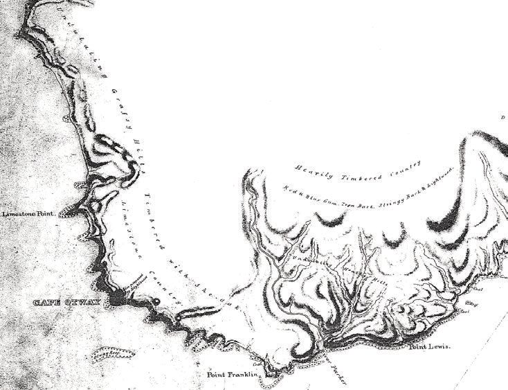
On the coast, we can gauge the effects of Aboriginal fire use and land
management practices from a survey map produced by George Douglas Smythe
in 1846. Created in preparation for the lighthouse construction project at Cape
Otway, Smythe chronicled the vegetation and forest communities found along
the coast, documenting a cultural landscape that had been transformed by the
fire-stick (Fig 5). The large timber forests had been left to occupy the highest, most
inaccessible terrain whilst the frequent pedestrian traffic between Cape Otway
and the Aire River was eased by the removal of heath scrub and its replacement
by grass cover. In such a zone of good soil, high rainfall and proximity to
vigorous forests, the appearance of grassland and the stark boundary with the
forest signals that this landscape mosaic was shaped and kept in place by the
regular application of fire to the land. By manipulating the seasonal timing,
intensity and frequency of fire deployment the Gadubanud people were able
to reconfigure vegetation communities and structure a landscape that fulfilled
their needs for sustenance and unhindered mobility along high traffic corridors.
More information regarding the application of fire to the region’s forests has
recently emerged from the study of sediment core samples taken at Chapple Vale,
Aire Crossing and Wyelangta. The data collected from swampy patches at Aire
Crossing (near the top of the Aire River basin) and Wyelangta were both found
to be in the midst of cool temperate rainforest stands that have experienced little
significant change from roughly 9000 years BP.66 Largely unmanaged by fire,
both sites possessed low charcoal readings. At Wyelangta, scientists found such
floristic stability that they believed ‘the site may be the first identified glacial
refugium for rainforest in Australia’.67 The sediment record from Chapple Vale,
a swamp site located on the western slope of the Otway Range, exhibited a
sudden and sustained rise in charcoal levels from around 2500 BP. Researchers
65 Gammage 2008: 251.
66 McKenzie and Kershaw 2000: 177–193, 2004: 281–290.
67 McKenzie and Kershaw 2000: 189.
190Gadubanud society in the Otway Ranges, Victoria
concluded that the ‘substantial increase in charcoal’ must have been the result of
frequent fire and that this ‘may have had substantial influence on the vegetation
from this time’.68 However, the appearance of so much charcoal in the sediment
record was not attributed to Aboriginal fire management. Instead, the authors of
this study maintained that climate was ‘a major controller of vegetation change
to sclerophyll communities’ at this site.69
Fig 5. Portion of map drawn by GD Smythe in 1846 during the course of a
survey in preparation for the construction of a lighthouse at Cape Otway.
Source: Public Record Office of Victoria, CS32-1 Aire River to Cape Patton.
Other studies of long-term environmental change in western Victoria have
attributed vegetation change to anthropogenic burning. When researchers
examining the Holocene sediment record at Lake Wangoom found reductions
in wet forest pollen taxa and higher representations in grass species (Poaceae)
they attributed change to the fact that ‘effective precipitation was lower than the
previous two interglacials, although it also may be a product of anthropogenic
burning in the region’.70 Favouring ridges for movement corridors across the
Otway Range, it is unlikely that the Gadubanud would have deployed fire near
swampy gullies found at Wyelangta and Aire Crossing. The significantly lower
68 McKenzie and Kershaw 1997: 577.
69 McKenzie and Kershaw 1997: 579.
70 Harle et al 2002: 718.
191ABORIGINAL HISTORY 2009 VOL 33
elevation of the Chapple Vale site, and its proximity to the Gellibrand River,
may have played a role in the extension of regular burning to this locale over
2000 years ago. Moreover, the timing of this change in fire pattern fits the wider
sequence of Aboriginal population shift from the plains of western Victoria
southward toward the forest hinterland and coast.71 This evidence points to
the extension of Aboriginal fire management to the western slope of the Otway
Range prior to the outright shift of population and land use practices to the
coast, and certainly well before the 1420 BP first occupation date recorded at Seal
Point.
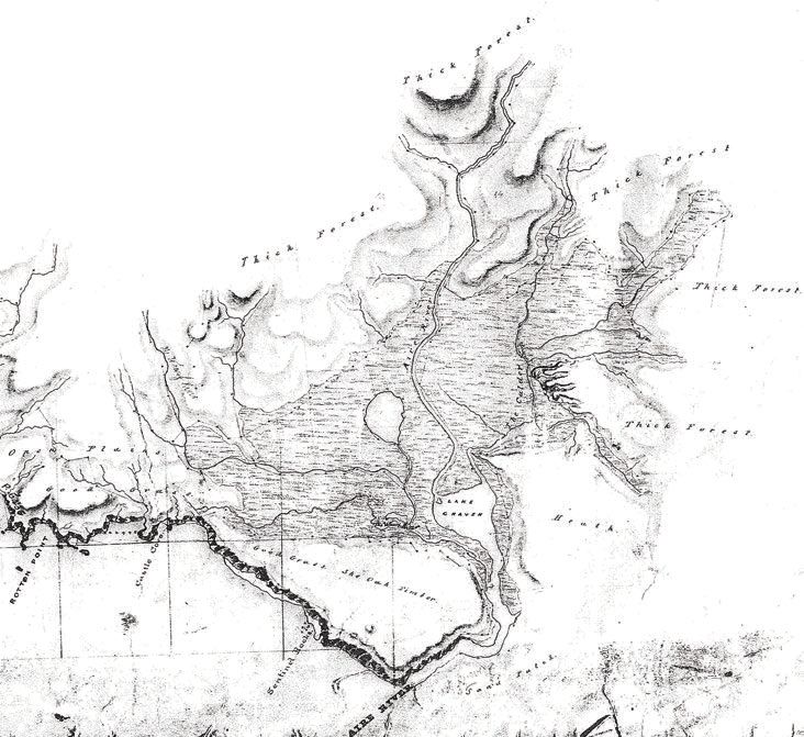
In May 1847, the westward extension of the coastal survey by Robert Hoddle
generated a picture of the Aire River estuary as an important site of economic
activity for the Gadubanud people. Hoddle’s map provides a detailed view
of this settlement area and the ways in which specific land use decisions were
inscribed in the land (Fig 6). Thick forests protected the northern and eastern
flanks of the basin so that a large proportion of the valley was shielded from
gales, and yet timber required for fuel and shelter material was kept close at
hand. A well-defined boundary between an open wetland–grass shore complex
and forest was undoubtedly maintained by fire. Selective burning also generated
a well-indented forest edge that could serve as a habitat for animals, while the
stark transition between open land and tall forests made these trees susceptible
to windfalls – a useful means of toppling large trees and harvesting wood fuel
in an age when only stone axes seem to have been available for this task. The
patchwork mosaic encouraged through selective burning allowed for low-lying
vegetation, mainly heath and grassland plains, to take hold near the coast where
pedestrian movement was channelled.
Atop the outcrop that divides the estuary from the sea, a conspicuous
configuration of ‘good grass’ and ‘she-oak timber’ marks a paddock used for
hunting kangaroos and wallabies. When the marsupials had been lured onto the
grass, the hunters would be able to spear the animals from behind the cover of
she-oaks with a high probability of success. The placement of this visual barrier
on elevated ground allowed for superior visibility of the surrounding terrain,
while a spear thrown downhill could cover more ground and maintain a higher
velocity. Even if a first attempt at spearing the animal missed its mark, the cul-
de-sac formation chosen for this paddock allowed easy blockage of the isthmus,
thereby forcing the spooked marsupials toward the marshes where their
movement rate was severely constrained and they faced little chance of survival.
While there may have been times when the Gadubanud lit fires at forest edges
to flush out game into the paths of hunters, the use of fire to concentrate feed in
paddocks of fresh grass and arrange visual barriers in the landscape allowed for
a more predictable procurement of meat protein at Aire River.72
71 This sequence of land use extension from more arid inland areas to the coastal hinterland during
the Holocene era is similar to that identified by Beaton in Queensland. See Beaton 1985: 1–20.
72 Bill Gammage has noted the existence of similar wallaby trap formations in Tasmania. See:
Gammage 2008: 251.
192Gadubanud society in the Otway Ranges, Victoria
Fig 6. Portion of map drawn by Robert Hoddle in May 1847 during a coastal
survey.
Source: Public Record Office of Victoria, CS33 Gellibrand River to Aire River.
Archaeological investigations at Aire River provide additional detail about
Gadubanud land use and economy. In 1960, John Mulvaney excavated two
rock shelters located on the north side of this outcrop, overlooking the wetland.
Radiocarbon dating of charcoal deposits yielded a base occupation date ranging
from 325 to 415 BP, and the rapid accumulation of debris – over six feet in depth
over the period of occupation – attested to the site’s popularity.73 Food debris
found on site included: marine shellfish, kangaroo, rats, birds, fish, seals and
abalone. This collection of remnants indicates that both coastal and estuary-
based animal protein were consumed by the people residing at the Aire River,
and indeed access to this wider range of foods must have heightened the appeal
of this locale. In 1979, IMF Stuart followed up Mulvaney’s investigation with a
detailed survey of the Aire River valley. Seventy-three archaeological sites were
recorded in the study, finding that ‘The vast majority (64) of these sites are shell
73 Mulvaney 1961: 1–15.
193ABORIGINAL HISTORY 2009 VOL 33
middens, but they also include 6 lithic scatters, 2 rock shelters and one isolated
artefact’.74 Local abundance of certain species made food procurement in the
Aire River area a simple task: on La Trobe’s third attempt to reach the Cape in
April 1846, in the vicinity of this estuary, he and companion Henry Allan feasted
on shellfish for breakfast before pushing on to their destination.75 The dietary
preferences indicated by the food debris found at the Aire River archaeological
dig were similar to those later exhibited at Seal Point. Subsequently, a shell
midden discovered nearby in a rock shelter at Moonlight Head was found to
be occupied between 1030 BP and 180 BP. This was likely a favoured spot of the
Ngarowurd gundidj clan identified by GA Robinson’s Gadubanud informants.76
This archaeological find extended the known period of Aboriginal presence on
this portion of the Otway coast and underscored the locale’s significance as a
settlement node.77
While the linkages between the Aire River and Cape Otway settlement nodes
are quite clearly evinced in the coastal surveys and La Trobe’s discovery of a
cleared path between these two locations in 1846, it is probable that alternate
movement corridors also existed in the Otway region. A more direct route
connecting the people of the Aire River estuary with those of the Barwon eel
marshes, circumventing Cape Otway, would have had a marked utility for the
Gadubanud people. Proof that a movement corridor along the main ridge of
the Otway Range may have linked the Gadubanud’s northern and western
clans first appeared in La Trobe’s journal. Approaching the Cape from the west,
his entry for 1 April 1846 noted that at Moonlight Head they came upon a trail
‘where taking a native path to the left we had gone up into the ranges’.78 Focused
on reaching the site of the future lighthouse, La Trobe and his guide did not
follow this path, instead choosing to continue along the coast to Cape Otway. In
1928, the headmaster of the school at Lavers Hill (located on the main ridge of
the Otway Range, several kilometres north-east of Moonlight Head) found three
stone axe heads left behind by the Gadubanud people. Reporting on this five
decades after the discovery, his son noted that the artefacts were found ‘beside
a soak or spring 100m to the north of the present Great Ocean Road’ and he
posited that ‘people used the site because of the close proximity of water to a
main trail along the ridge, making descent into the more thickly vegetated gullies
unnecessary’.79 Since such a path would be kept open with regular burning, the
axes were not used for felling trees. More likely, they were used to notch tree
trunks so that hunters could climb up and capture possums. Trail blazing had
the added benefit of encouraging the growth of wattle trees, whose gum was
edible. Gum was harvested during the autumn by cutting notches in bark to let
the gum exude, where ‘It is then gathered in large lumps, and stored for use’.80
74 Stuart cited in Presland 1982: 4.
75 Blake 1975: 18.
76 Clark 1990: 189.
77 Richards 1998: 10–12.
78 Blake 1975: 18.
79 Douglas 1978: 222.
80 Dawson 1881: 21.
194Gadubanud society in the Otway Ranges, Victoria
It would have been a convenient source of sustenance during a trek over the
mountains in time for the eel harvest on the north side of the range. Though
there is a great deal of uncertainty regarding this particular path through the
Otway forest, there are good reasons why the Gadubanud would have deposited
axes at rest stops along the route between the Aire River and Barwon wetland
settlement nodes.
The arrival of Europeans in the Otway region during the late 1840s led to the
violent disruption of Aboriginal society and ended a long-standing system of
land management. With the cessation of burning practices, surface vegetation
could experience rapid ‘thickening’ and hinder pedestrian movement. West of
Cape Otway, in April 1846 Superintendent La Trobe walked along the coast at a
comfortable pace, utilising the corridors cleared by the Gadubanud. He moved
quickly across this part of the region, requiring one day to reach the Gellibrand
River from the Allansford station, another to walk between the Gellibrand and
Johanna rivers, and a final one to reach Cape Otway.81 Only three years later, in
March 1849, La Trobe and his party encountered much difficulty and marched
at a considerably slower rate of movement. The landscape had not been burnt;
the coastal heath grew wild, scrub took hold in places it had not been allowed
previously to grow, and the vegetation thickened. The 20 to 25 miles from Apollo
Bay to Cape Otway were completed with relative ease along the numerous
beaches, but west of the Cape he found the travel much more strenuous:
The 40 or 50 m. from the Cape to the Gellibrand was not achieved
without a good deal of exertion, a great deal more indeed than on my
first excursion, for it was found quite impossible to follow my old track,
and it was not until the fifth day that we managed to fight our way
through that terrible scrub, and across the precipices of Moonlight Head
to the camp where the horses were awaiting us.82
In the absence of the fire-stick, the character of coastal vegetation changed
rapidly. Where La Trobe had required two days to move between Cape Otway and
the Gellibrand River in April 1846, only three years later the very same journey
required five days. In this way, the disruption of Aboriginal society came to be
expressed in the land: heath and scrub thickened, the landscape mosaic began to
possess less defined boundaries between vegetation communities, well-tended
environments began to build up fuel loads and wood debris. In January 1851,
the Black Thursday fires swept through western Victoria and incinerated great
swaths of the Otway forest.
Conclusion: the reconstruction of an Aboriginal cultural landscape
The Gadubanud people of the Otway region cared for their country and
their imprint could be witnessed in the cultural landscape they created. The
81 Blake 1975: 18.
82 Blake 1975: 36.
195ABORIGINAL HISTORY 2009 VOL 33
reconstruction of patterns of settlement, land use and communication requires a
patient engagement with studies produced in a diverse set of disciplines ranging
from the earth sciences to geography and archaeology. The identification
of past geographical patterns allows us to piece together the decisions and
constraints dealt with by generations of Aboriginal land managers that led to
the development of a distinct cultural landscape. Knowledge about the land-
based economy, the distribution of population and the food sources utilised by
the Gadubanud people can help us protect the Aboriginal heritage of this region,
guide future development away from areas of cultural and archaeological
significance, and highlight the ways in which environmental constraints guided
land use by Aborigines and later European occupants of the Otway region.
Fire was an important tool utilised by the Gadubanud people. It was essential
for clearing movement corridors along the coast and through the forest, and
allowed them to generate a complex landscape mosaic that increased the variety
of foodstuffs located within walking distance of key settlement areas. For them,
the Otway region was indeed a living larder. By alternating patches of high and
low fire fuel this mosaic enabled the geographical spread of risk across their
territory in the event of unexpected wildfire. Landscape complexity equated
with food security in that the health and longevity of their people was ensured
should there happen to be a localised collapse in the food resource. Working
on the other side of the Bass Strait, Bill Gammage found a similar situation
amongst the Aborigines of Tasmania: ‘With patches spaced over many miles,
their resources were more drought, flood and fire evading, more certain, than
those of farmers’.83
Acknowledgments
The author would like to thank Nicholas Brown, Bill Gammage, Tom Griffiths
and Jock Galloway for helpful comments on an earlier version of this paper.
References
Newspapers
Geelong Advertiser
Secondary sources
Ashton, DH 1976, ‘The development of even-aged stands of Eucalyptus regnans
F.Muell. in Central Victoria’, Australian Journal of Botany 24: 397–414.
83 Gammage 2008: 247.
196You can also read