Above Haeckel Hill Thay T'äw - A guide to from - ExploreNorth.com
←
→
Page content transcription
If your browser does not render page correctly, please read the page content below
VIEWING
 WHITEHORSE

    Above
  from

  A guide to
  Haeckel Hill • Thay T’äw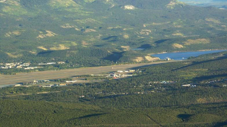
Contents Overview of the City of Whitehorse
Welcome to Haeckel Hill, p.1
Getting around, p.3 Takhini to
Dawson City 5 km
Wind power & the turbines, p.7 River
Rocks & glaciers: Keys to the
to
landscape, p.14 Haines
Whiteh
orse cit
Vegetation at the top, p.19 y limit
Junction s
way
Stevens Hidden Valley
Wildlife to watch for, p.22 and Livingston Trail
igh
Alaska MacPherson sewage
People in the area, p.24 eH
dik treatment lagoons
MAPS lon
Ala
K
ska
Overview, this page “true” Hi Cousins
At the top, p.3 airstrip
gh
Haeckel
way
Hill
Geology, p.14
Glacial, p.17 Haeckel
Yu k
Hill
Traditional lands, p.24, 25 n
R iver
o
Crestview
Some named mountains, back cover
Taylor
©2002 Kulan
Yukon Energy Corporation, Rabbit’s Foot Porter Creek
(867) 393-5300 Canyon
landfill Yukon
Production: (dump) Arts old
K-L Services Centre sewage
treatment
Danièle Héon, Geologist ponds
Janne Hicklin oad
eR Kopper h ini Marwell
(Whitehorse, Yukon) ak King Tak
L
Long Lake
h
Fis
Valleyview
This guide is provided by Yukon
McIntyre
Energy as a community service. Marsh
McIntyre Two Mile Hill
t
Every effort has been made to cres DOWNTOWN
Arkell Hill
verify the information provided r
Logan nge
here. Any suggestions you have Gra
Copper
for inclusion in future printings Ridge
W h i t e ho
Riverdale
e Creek
are welcome. USE OF ACCESS
ROAD AND AREA IS STRICTLY
rse Copper Mine
tyr
Lobird Hidden Lakes
AT YOUR OWN RISK.
M cIn
All photos by Peter Long, Schwatka
Lake
Boreal Alternate Energy Centre,
Yukon Energy or Janne Hicklin. Whitehorse Chadden Lake
H
Copper Canyon
aul Road
Crescent uk
Y
One in a series of local guides. o
Grey Mountain
n
Also available: Enjoying
River
Mount
Whitehorse Trails and Exploring McIntyre
• Tran
the Whitehorse Fishway. Chadburn Lake
Alaska H
Mount McCrae
s Can
Sima
Thanks to… ski hill
ada T
i gh
Bruce Bennett • Jeff Bond
Jesse Devost • Hugh Henderson
way
rail
Stephen Kendall • Dennis Kuch
Val Loewen • Gillian McKee Pineridge
Randi Mulder Wolf
Creek
Rene Pelkilometresan
J.P. Pinard Spruce Hill
Louise Profeit-Leblanc
Charlie Roots • Eric Rudell
k
Jeff Stanhope • John Stinson
ree
Mary to
Gary Stronghill • Gerry Whitley
fC
Lake Teslin
Mary Whitley • Roslyn Woodcock
ol
Golden Horn Mountain W Cowley
Creek to
Special thanks to
Kwanlin Dun First Nation Carcross
Ta’an Kwäch’än First Nation
Warning! The rough gravel road up Haeckel Hill is a public road
Publié aussi en français et en allemand.
but is not maintained. It is not suitable for long vehicles such as
Auch auf Französisch und Deutsch
erhältlich. mobile homes, nor is it a winter road. Drive with extreme caution.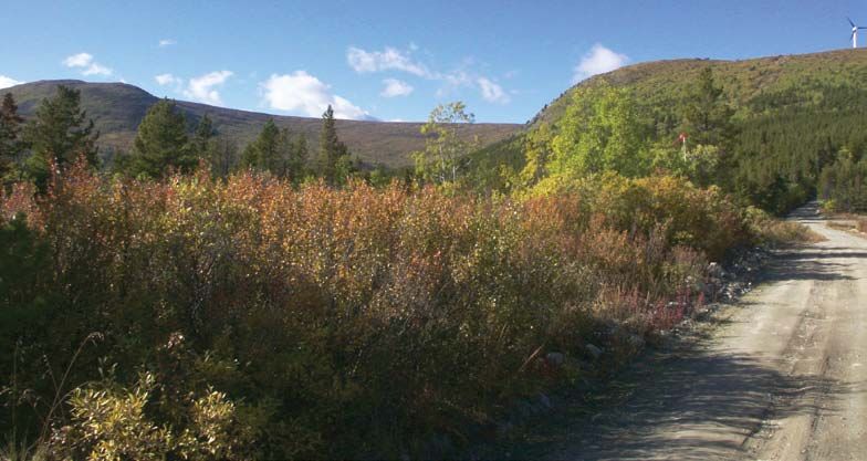
Welcome to Haeckel Hill
O     f all the mountain or hilltop
      viewpoints in the Whitehorse
area, Haeckel Hill is one of the most
                                              Haeckel Hill became attached instead
                                              to the highest point of land at the end of
                                              the road. The “true” Haeckel Hill forms
noticeable. The two Yukon Energy wind         one of the boundary markers for the
turbines atop the hill make it a very         Whitehorse city limits.
distinctive landmark. At a height of          At the top of Haeckel Hill, you can
1,433 metres above sea level or about         crouch down to see the rocks and
800 metres above the Yukon River, this        lichens, or stretch your view to distant
site offers an unusual opportunity to         mountain peaks. You can observe the
join the soaring eagles for a great birds’-   results of geological processes that span
eye view! Appropriately, the Southern         over 200 million years. Change still
Tutchone name for this height of land is      occurs at rates so slow, it is difficult to
Thay T’äw, meaning “eagle nest.”              notice.
This booklet describes a part of the          Regardless of how much time you have,
Sumanik Massif, the large hill which          this guide will help make your outing
extends farther to the northwest of           more fun. It provides an overview of
Haeckel Hill. In fact, the name “Haeckel      what you can see in four directions.
Hill,” adopted in the late 1800s after
Ernst Haeckel, a renowned German              Use the maps (listed on opposite page)
ecologist, officially belongs to another      to orient yourself. Read the sections
hill which is part of this same massif.       on wind turbines, geology, vegetation,
Once a road was pushed in for the             wildlife and human history of the area.
fire tower, and sites were developed          For your safety, and to protect the very
for telecommunications equipment              fragile alpine environment, please stay
and wind power generation, the name           on the trails.

Looking east towards Grey Mountain, over the airport and Schwatka Lake.

                                                                                            1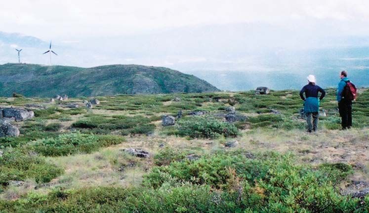
Getting to the top When to go
Travel north on the Alaska Highway If the skies are clear, the view from the
towards Haines Junction. Turn left onto top is spectacular. Strong winds make
the Fish Lake Road, 2.9 kilometres west Haeckel Hill a good site for harnessing
of the Alaska Highway–Two Mile Hill wind power, but the combination of
intersection. altitude and wind chill often means that
in summer it is colder at the top than in
Drive 3.4 kilometres. Turn right onto town.
a dirt road at the four-way intersection
It is best to avoid the hill in winter. Ice
marked by a large rock commemorating
that forms on the wind turbine blades
the Pueblo Mine disaster. (Or park at
is thrown off at high speeds and often
the McIntyre Marsh wildlife viewing site
lands far from the tower.
and walk up, about an hour.)
Go past the private fish farm at the What to take
start of the dirt road. It is 6.5 kilometres Bring warm clothes, including a wind-
from here to the top, about 15 minutes proof jacket and pants, hat and gloves. In
of slow driving on rough surfaces with July and August, wear long sleeves and
occasional sharp turns. (Park off the pants as protection from bugs. Some-
road and walk up if it is too rough.) times, a hat with mosquito netting is
called for. Footwear should be suitable
Near the top, the road widens for rugged terrain; you will encounter
considerably as you arrive at a flat, open jagged rocks, snow into the summer
area. Do not drive up either driveway as months and some wet, boggy areas.
the barriers may be locked at any time.
You could also bring along any of
Instead, park off to the side, leaving
the following: binoculars, camera,
room for service vehicles to get by.
topographical map (105D Whitehorse),
Walk up the left driveway and compass, magnifying glass, books on
you will arrive at the base of two geology, alpine flowers and birds, and
impressively large wind turbines. water and snacks.
Please respect the equipment!
At the south end of the hill is a piece
of property owned by the Government
of Canada. It contains microwave
communications equipment, exposed
electrical cable, a wind monitoring station,
lightning detectors, RCMP communications
equipment and a fire lookout station staffed
from May through August. (Never disturb equipment. Down the hill and to the
the fire-watcher!) Walking through or northeast of the fire lookout, an orange
immediately below this area poses potential cylindrical structure contains equipment
health and safety risks and may interfere used for earthquake prediction and a
with microwave transmission. receiver that tracks satellites to aid in
Just below the fire lookout is a dark- precision mapping. This station, which links
green pillar called a “comshell,” a secure, into other geodetic control stations, is a
weatherproof home for communications vital part of the Whitehorse survey system.
2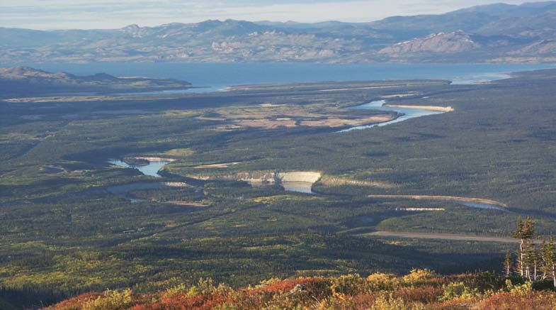
1100
                                                                                                                    1125
                               1500                                                                                1150
                                1475                                                                            1175
                                                                                                              1200

Getting around
                                 1450
                                    1425                                                                   1225
                                                                                                           1250
                                       1400
                                                                                                       1275
                                        1375                                                                               1

I  t is easy to spend several hours on
   Haeckel Hill, just wandering around,
                                       1350

looking out at the spectacular views all1325                               130
                                                                                0m
                                                                                               500 m

                                                                                             135
                                                                                                 0m
                                        1300
around, listening to the endless whoosh
                                     1275
of the turbine blades.
If it’s sunny, you may notice the shadow
of the blade tips going quickly past you                               1425 m
                                                                     1400 m              P
like a strobe light. This is known as the
“disco” effect and constant exposure to
                                                                                               to
it can cause psychological discomfort.                  trails             road
                                                                                               Fish Lake
                                                        orientation of cliffs, gullies
                                                                                               Road
As you look around, imagine yourself
in a time long ago, following well-            1,000 metres, is Fish Lake. Louise Lake
established trails east from Fish Lake         is in the foreground. At 2,088 metres,
along to the Yukon River, north to the         Mount Granger is one of the highest
Ibex, west to the Takhini River, or south      peaks in the area, just behind Fish
towards Carcross. Although roads and           Lake. On a clear day, the snow-capped
other development have replaced or             peaks of the coastal range are visible in
obliterated many of these routes, some         the distance to the west.
original trails are still in use today.
                                               To the southeast, you can see features
South towards Fish Lake                        such as the Whitehorse Airport, the
Before walking up the path towards             Alaska Highway winding south through
the wind turbines, look south from             the McCrae industrial area, and the
where you parked. The large body of            Whitehorse Copper Mine Haul Road.
water directly across the valley, at           Peaks that may help orient your view

Looking south towards Fish Lake, with Mount Granger in the background. Ice once filled
this valley. Dashed lines mark glacial sediment left behind by melting glaciers retreating
towards the mountains.

                                                                                                                       3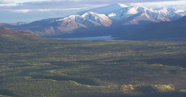
include Grey Mountain (officially
    known as Canyon Mountain), Golden             Echo Valley forest fire
    Horn Mountain, Lorne Mountain, Mount          In 1991, a fire that started in a gravel
    McIntyre, and the ski slopes on Mount         pit in the Sumanik Massif area turned
    Sima. Note the large, brown scar left         into a massive blaze which burned
    from a forest fire that threatened the        1,500 hectares.
    Hamilton Boulevard-area subdivisions          The fire travelled uphill and around the
    in the late 1990s.                            east side of the massif before firefighters
                                                  contained it. A cut-line bulldozed up
    North towards Lake Laberge
                                                  the hill successfully prevented it from
    To fully appreciate the view north, you       spreading further. Look for that cut-line
    must walk right to the top, near the          running vertically up the far side of the
    larger wind turbine. In front of you, the     next valley. To the right of this line is a
    terrain drops down into a valley and          forest of standing burned trees and to the
    up again to the long east-west ridge of       left, a living pine forest.
    Mount Sumanik.
                                                  The influence of the wind gave the burn a
    Out in the broad Yukon River valley,          sweeping fan shape, as seen from above.
    look for the clay cliff banks flanking the    You can see the fire scar from both the
    winding Yukon and Takhini rivers. Note        Alaska and the Klondike highways.
    where the Takhini River flows into the
    Yukon River, which is heading north
    through Lake Laberge on its 3,000-           West towards Mount Sumanik
    kilometre journey to the Pacific Ocean.      For a leisurely one-hour stroll, follow a
    The long, straight stretch of road is the    fairly visible, well-worn path starting to
    Klondike Highway, linking Whitehorse         the west of the larger turbine. This path
    to Dawson City.                              leads down across a shallow, fertile gully

    Looking north towards Lake Laberge, note the clay cliffs lining the Yukon River which
    cuts through and washes away fine sediment deposited by an ancient glacial lake. The
    Klondike Highway can be seen near the left edge, after it crosses the Takhini River.

4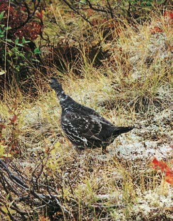
Whitehorse. The Whitehorse landfill,
                                                located in the mined-out pit of the War
                                                Eagle copper deposit, dominates the
                                                near view.
                                                To the south, the Alaska Highway
                                                intersects Two Mile Hill, the north
                                                access into the city, and then passes by
                                                the airport. On the far side of the Yukon
                                                River, the Whitehorse sewage lagoon
                                                looks like a series of small lakes.
                                                On the facing lower slope of Grey
                                                Mountain, you can trace the road
                                                upward to Northwestel’s 91-metre and
                                                38-metre microwave towers, about
Looking west to Mount Sumanik. The
                                                20 kilometres away. If it is clear, Marsh
valley on the left side faces east and is
thick with dark green spruce, while the
                                                Lake may be visible just around the
higher, south-facing hillside to the right is   south ridge of Grey Mountain. Near
covered in pine.                                the base of Mount McIntyre, note the
                                                Mount Sima downhill ski trails and the
and then up onto a rocky knoll. For a           abandoned Whitehorse Copper Mine
brief and intense few days in early July,       tailings in the prominent open flat area.
this trail is an ideal spot to view alpine      The long ridge of Cap Mountain
wildflowers in bloom.                           dominates the far side of the valley.
The trail fades out as you approach
the top of a steep, rocky cliff facing
west, across a thickly vegetated valley,
towards Mount Sumanik.
For the agile hiker, a clamber around the
rocky rim to the north offers different
perspectives on the geology of the hill.

East towards downtown
For a good view eastward, take the path
toward the fire tower from where you
parked until you reach the chain across
the road. Beyond is private property.
Cut right around the rim of the hill to
the open ridge which heads east. Stay
well below any equipment.
From here, head down the hill towards
the river and the landfill site for a mix
of great views, bushwhacking and easy
hiking. Notice the stair-like nature of
the hill.                                       Looking east, with evidence of caribou in
                                                the foreground. The landfill and the Alaska
The view encompasses most of                    Highway coming into Rabbit’s Foot Canyon
the developed area in and around                are visible in the background.

                                                                                              5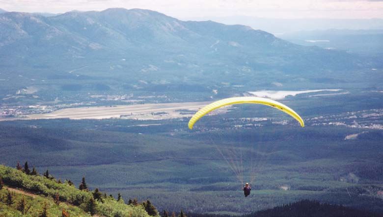
Day hike to Mount Sumanik
    The nearest mountain to Haeckel Hill is
    Mount Sumanik, the broad ridge 268 metres
    higher to the west. It was named for Don
    Sumanik, a founder of the ski club and
    responsible for bringing the Nordic World
    Cup to Whitehorse in 1982. From the wind
    turbines on Haeckel Hill, you can walk to the
    top in four to five hours.
    Head west from the larger wind turbine and
    descend the hill along the first gully. You’ll
    join a cat-trail cut during the 1991 forest
    fire. At the bottom of this trail is a meadow-
    like valley between the hills.
    Bear left across the meadow and look for
    the track leading up the opposite slope to
    the ridge top. Avoid bushwhacking as this
    is a fragile environment. Once on the ridge,     Heavy boulders carried by the flowing
    note where the trail is so you can be sure to    ice were left when the ice melted
    find it upon your return.                        and fine material eroded away.
    By continuing west along the ridge top, you
    will eventually reach the top of Sumanik, passing wind monitoring equipment along the
    way. There are many boulders scattered around so be careful of your footing. From the
    top of Sumanik, you will have wonderful views, including into the Ibex Valley.
    Note: Hiking straight across the valley to Sumanik may look more direct but heavy brush
    and tough going will add many more hours to your hiking time.

    Looking back towards Haeckel Hill from the ridge on Mount Sumanik.

6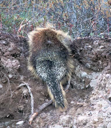
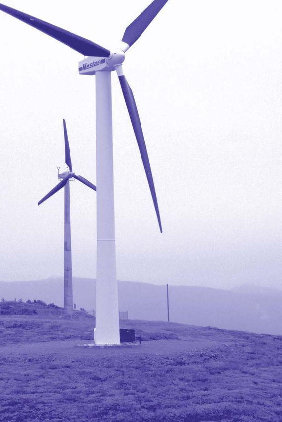
Wind power & the turbines
“Wind is totally benign and it’s totally            Cable, a chemical engineer, lawyer and
renewable. You just wait until the wind             the current Yukon commissioner.
blows. You’re not burning any fossil fuels          Thinking that wind potential might be
and creating carbon dioxide. You’re not             better at higher elevations, Craig dug
damming up a river.”                                through records of Whitehorse weather
                                                    balloon information from Environment
                    Jack Cable, former president,   Canada. He observed that good wind
                                   Yukon Energy     velocities did exist at higher altitudes.

Y   ukon Energy’s two wind turbine                  Encouraged, Craig and Cable set up the
    electrical generators that sit atop             Boreal Alternate Energy Centre in 1990
Haeckel Hill are a spectacular sight. The           to explore energy options.
Bonus 150 kW, the smaller of the two,               Boreal rounded up two NRC wind
was erected in July, 1993 and the larger            monitoring instruments left in the
turbine, the Vestas V47-660 kW, was                 north from previous studies. With a
installed in September 2000.                        truck loaned by The Yukon Electrical
                                                    Company Ltd. and $1,500 that Yukon
Yukon wind pioneers                                 Energy Corporation contributed, Boreal
After a number of disappointing trials              was able to erect its first tower at the
in the 1980s, the National Research                 1,430-metre level on Haeckel Hill.
Council (NRC) and the Yukon                         Despite instrument icing problems,
government almost wrote off wind                    Boreal demonstrated that Haeckel Hill
generation in the Yukon. However, wind              experienced 10 times more wind energy
got a second chance from two long-                  than the Whitehorse airport.
time Yukon residents, Dr. Doug Craig, a             In 1991 and 1992, instruments on
geological engineer, and his friend, Jack           Mount Sumanik, at 1,550 metres,

  WIND MONITORING records wind speed,               wind data helps determine the economic
                   direction and                    feasibility of installing a wind turbine.
                   temperature to assess            There are currently wind monitoring
                   the potential for wind           programs on Haeckel Hill and Mount
                   generation. Sites for            Sumanik, along the Fish Lake Road, in Faro,
                   wind monitoring are              Stewart Crossing, Carcross, and by Lake
                   chosen because of local          Laberge, Kluane Lake and Fox Lake.
                   knowledge of high wind
                   regime and because                                               Rime ice on
                   of their proximity to a                                          monitoring
                   powerline or to a house                                          equipment
                   that is off the electrical                                       on Haeckel
                   grid. It is important to                                         Hill, 1994.
                   monitor a site for its                                           Only heated
  Collapsed tower, wind energy potential                                            instruments
  Flat Mountain,   for at least a one-year                                          stay clear of
  1991.            period. Analyzing the                                            ice.

                                                                                                    7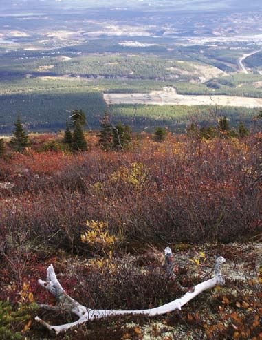
Rime ice
                                   “Rime icing is a white frost-like build-up that you see
                                   on branches and trees around open water and occurs
                                                   whenever there’s a cloud contacting a
                                                   mountain or ridge.
                                                  “Any solid object accumulates ice which
                                                  ‘grows’ into the wind. Trees become ice
                                                  domes, towers become ice posts, power
                                                  lines grow to six or eight inches in diameter,
                                                  and chainlink fences become solid walls.”
                                                                            John Maissan, Director,
                                                                   Technical Services, Yukon Energy

      After years of monitoring on Yukon mountaintops, it has been found that rime ice is
      the single biggest obstacle to wind power generation. Annually, there are over 100 days
      of icing. Without ice prevention technology, this would lead to a 25% or more loss in
      energy production from the wind turbines.

    and on nearby Flat Mountain, at                 In winter, too, the valleys often fill with
    1,940 metres, revealed 15% and 30%              heavy, cold, slow moving air while the
    wind energy increases, respectively.            stronger upper winds continue to howl
    By late 1992, Yukon Energy was                  at the mountaintops. This colder valley-
    negotiating with Bonus A/G of Denmark           bottom air phenomenon is known as
    to purchase its first wind turbine. This        an inversion — the temperature rises
    would establish the possibilities for           with elevation. On Haeckel Hill, it may
    wind generation elsewhere in the Yukon.         be several degrees warmer and windier
                                                    than in the valley. Often, when there
    Wind and weather                                are low clouds over Whitehorse, on
    Generally, stronger winds are found             top you will be in a clear, sunny day,
    on high hills and mountains almost              looking down at a river of clouds below.
    anywhere in the Yukon. (Rime icing is
    present in many of these locations.)             Landscape and climate
    The year-round prevailing wind in                The Whitehorse area is located at the
    the Whitehorse area comes from                   southwestern edge of the Yukon Plateau,
    southern directions with an occasional           a vast area of moderate elevation in the
    winter north wind. In the valley where           interior, characterized by hills, valleys and
    Whitehorse lies, the wind tends to be            large rivers.
    oriented along the valley axis; that is, it      The Coast Mountains to the southwest
    will either come from the north-north-           feature steeper terrain and higher elevations.
    west or the south-south-east.                    They act as a barrier to the moist air masses
    On Haeckel Hill, wind direction is more          coming north from the Pacific Ocean,
    variable. South winds tend to range              receiving significant precipitation and
    from the south-west to the south-east.           causing the climate in the interior (this area)
                                                     to be much drier.
    In winter, there may be north winds.

8
The first turbine
Bonus 150 kW
Mark III
The Bonus 150 kW
wind turbine was
erected at a cost
of $800,000. The
goal was to see if it
was possible to use
wind to generate
electrical power in
the Yukon’s sub-
arctic climate.
Specifications
• 150 kW capacity, 160 kW peak
capacity; two speeds (30, 40 rpm),
two generators.
• 30-metre hub height (tubular
tower); three, two-piece fiberglass
Anvil clouds, looking south. blades; 23.8-metre diameter blade
circle; works in winds from 14 to
Look for the anvil-like appearance of 90 kilometres/hour.
storm clouds as high-altitude, high-
velocity winds race across lower clouds • In high winds, the blade tips feather
and flatten their tops. Watch the winds out of the wind, slowing the speed
as they swirl around Grey Mountain until the automatic brake stops it.
forming clouds around the peak. These • Normal operating range to -30°C.
are common cloud features on warm
summer days in this area. Special Yukon features
Because of the particular weather
People who live north of the Takhini
conditions under which the Bonus
River are familiar with a “weather
would be operating, modifications were
divide” which makes that area much
made to the equipment.
clearer and dryer than Whitehorse.
From the top of Haeckel Hill, you may These included a hinged 30-metre
be able to see a distinct difference in tower capable of installation without a
the cloud-cover. large crane; low-temperature-tolerant
steels; synthetic lubricants; six-inch
Blade spinning Seen from downtown, heating strips for blade leading edges;
if the blades appear to turn clockwise, the and heating systems for the gearbox,
wind is from the south; if counter-clockwise, generator, electronic cabinets and
the wind is from the north. If the blades are monitoring-instrument bearings.
not turning, there is insufficient wind, the
equipment is down for maintenance or they Challenges and solutions
have been automatically stopped because it When blade icing occurred behind
is too windy! the heaters, wider heating strips and a
9special coating were installed to shed
the ice and increase efficiency. On the leading edge
Icing on the overhead power lines “The systems to maximize the actual
caused outages so the lines were buried power output in our adverse conditions
to eliminate the problem. When the — lower temperatures and rime icing
heated bearing instruments iced up, — were very much leading edge and
fully heated instruments were installed. still are in terms of what’s happening
The two-section blades caused tip throughout the world.
heater problems. Unfortunately, rime
“Just by doing what’s good for us we’ve
icing still causes efficiency losses.
developed expertise in a niche market
1 that is suitable for use anywhere in
northern North America, Scandinavia or
Siberia, for instance.”
John Maissan, Director,
Technical Services, Yukon Energy
1, 2) Installation: A crane lifted the tower
from the cradle high enough so that a
hydraulic winch, secured by a Cat, could
apply leverage through the gin poles to pull
the tower vertical. 3) Heating strips. 4) Icing
on the blades. 5) Applying black coating.
3
4 5
2
10The second turbine and one-piece, variable pitch wind
blades to maximize power production.
Vestas V47-660 kW
The Vestas V47-660 kW was erected Specifications
on Haeckel Hill at a cost of $2,000,000. • 660 kW peak capacity; single speed
The goal for the Vestas is to test the (28.5 rpm), single generator.
commercial viability of wind power. • 37-metre hub height; three fibreglass
Features suited to Yukon conditions blades; 47-metre diameter blade
include a tubular tower for indoor circle; works in winds from 14 to
climbing sheltered from the weather 90 kilometres/hour.
• In high winds, the whole blade turns
to feather out of the wind, slowing
the speed until the automatic brake
slows it to a stop.
• Normal operating range to -30°C;
includes low temperature steels and
other cold climate modifications.
The crane used to erect the new tower
on its way up the newly widened road
towards the Bonus.
“The Vestas tower was built in North
Dakota. We had to bring up parts from all
over the world — Denmark, the United
States and places like Mexico. Roadwork
was a big stage. The road up Haeckel Hill
was not adequate to take a turbine the
size of the Vestas. And getting a 180-
tonne crane up there was no easy matter.
“We needed low-temp packages for
the turbine to be able to work in the
middle of winter when our best winds
are. We actually had to put our own
modifications on the blades for blade
heating and anemometers and wind
vanes. We couldn’t use the standard
Vestas anemometers.”
Bill Haydock, Supervisor,
Mechanical Engineering, Yukon Energy
111 5
2 6
3 4
1) Tightening one of the many bolts holding
the tower in place. 2) Joining a blade to
the hub. 3) Looking up the ladder, inside
the tower. 4, 6, 7) Mounting the blade/hub
assembly to the nacelle. 5) Lining up the
second part of the tower.
12Green energy amount of power as 350,000 litres
of diesel, the equivalent of reducing
Green power is electricity produced
greenhouse gas emissions by about
from renewable sources in an
1,000 metric tons.
environmentally sustainable manner.
The work on Haeckel Hill is laying the The Vestas is still going through a tuning
foundation for future wind projects, a up stage to overcome rime icing. This
known source of green energy. phase took two to three years on the
Bonus machine. Until rime icing effects
The Vestas wind turbine will generate
can be overcome, commercial viability
enough power for 130 homes yearly,
of wind power as a source of electricity
compared to 23 homes for the Bonus.
is possible only in the longer term.
In one year, it will produce the same
Studies show that wind lower down
in valleys may be economic in
Look up! combination with solar energy for small
off-grid applications such as a lodge,
The wind turbines normally produce but is not adequate for commercial
power about 70% of the time during the generation. The one possible exception
windier, winter months, dropping to less to this so far is Destruction Bay.
than 50% in the calmer, summer months.
Ongoing studies into the feasibility of
The Yukon’s power grid now uses wind using wind to offset diesel generation in
energy first, run of the river (Whitehorse Old Crow and Destruction Bay are being
Rapids) hydro second, reservoir storage done in cooperation with the Vuntut
(Aishihik Lake) third and diesel last. Gwitchin First Nation and the Kluane
First Nation, respectively.
7
13Rocks & glaciers: Keys to the landscape
T he land before you has been shaped
by complex and intense cycles of
earth building processes that span more
25 km
than 200 million years! Fox
Lake Lake
Rocks of the Whitehorse area were
Te
Laberge
s
lin
created by the action of volcanoes, and
Ri
ve
by the wearing down of these volcanic
r
rocks through erosion. Other rocks
resulted from melting of the earth’s crust
into magma (or molten rock). Following
mountain building, all these rocks were
eroded back down to the level that we
see today. Recently (in geologic time), Alaska
thick ice sheets repeatedly covered Ibe
xR
the landscape, both emphasizing pre- ive
r Whitehorse
existing features and creating new ones.
Yukon Digital Geology, GSC Open File D3826
Erosion continues to happen today. Fish
Lake
Bedrock Highw
ay
Volcanic islands: Two hundred million
years ago, the oldest rock (green on
map), including those of Haeckel Marsh
Hill itself, formed a chain of volcanic Lake
islands off the shore of western North
America. As the volcanoes grew and the
Stikinia-volcanic and sedimentary rocks, 200 million years old
islands rose above the surrounding sea,
Granites and related volcanic rocks, 110 to 60 million years old
rock fragments were washed away by
Recent volcanic rocks, 8 million years old
erosion, and accumulated as sediments Thick glacial sediments, younger than 1 million years old
on the flanks of the islands and on Other rocks
1 2
Some rocks are composed of rounded pieces of various pre-existing rocks (1). Others
show a layering within the rock (2). Defined by changes in colour or in particle size, this
layering was formed by the settling of particles of sand, silt and mud. The layering, also
known as bedding, was near horizontal when the sediments were deposited.
14cycle of freezing and thawing. This area
Whitehorse Copper Belt has been glaciated several times during
Copper deposits called “skarns” are the past three million years.
formed when molten fluid-rich granite The ice sheets that covered this area
intrudes cold limestone. Ore, worth more were born in the high mountains near
than $500 million, was produced from the coast. The rising land caused the
24 deposits stretching 30 kilometres, accumulation of permanent snow
from the City of Whitehorse dump to the and ice. With continued cooling and
Carcross Road. precipitation, the ice sheet thickened,
grew and started to flow, eventually
the sea floor. Limestone reefs grew reaching lower elevations.
in the warm ocean water. Limestone Even the nearby mountaintops were
forms the light grey rock seen on Grey buried in the kilometres of ice. The great
Mountain, Mount Sima, and in Rabbit’s weight and slow movement of the ice
Foot Canyon. The volcanoes and their sheet pulverized the underlying rock,
sediments formed an ancient continent and debris was carried downhill by the
that geologists call Stikinia Terrane. ice. As temperatures started to rise,
Continental collision: Between 60 and ice melted and this debris was shed as
110 million years ago, tectonic forces deposits of silt, sand and gravel. A large
caused Stikinia Terrane to collide with glacial lake formed which eventually
ancient North America. The resulting drained when it breached its own dam.
friction generated so much heat that The debris left behind by melting ice
the lower crust started to melt, forming is glacial till, a disorganized mixture
magma that rose through the earth’s of rock fragments ranging in size from
crust. The magma cooled into light- clay to boulders (1). Till deposits can be
coloured rock called granite (pink observed in the road cuts above the fish
on map). Some of the peaks around farm and on the Fish Lake Road near the
Whitehorse, such as the tops of Mount Alaska Highway.
Sumanik, Golden Horn, McIntyre and
Granger, are underlain by granite. A Several glacial features can be observed
large body of granite hosts the copper from the top of Haeckel Hill. Lake
deposits of the Whitehorse Copper Belt, Laberge is one of the remnants of the
and is visible at the start of the Fish large glacial lake that filled the valley
Lake Road.
1
Recent volcanism: The youngest rocks
(brown on map) are lavas that flowed
less than nine million years ago. Some
of these form the basalt cliffs of Miles
Canyon and provide the foundations for
the Whitehorse Rapids hydro dam.
Glaciers: The legacy of ice
The area around Whitehorse is a mature
landscape as the surface has been
sculpted by erosion for a very long time.
Valleys were carved by water; mountains
were rounded by rain, wind, and the
15Linear features represent till that was deposited on the side of the glacier as it thinned (lateral
moraines), as well as mark beach lines showing the shores of the later glacial lake. The clay
cliffs and flat area around the airport were deposited as fine sediments at the bottom of the
glacial lake. Arrows mark Whitehorse Rapids dam (right) and the airport control tower (left).
11,000 years ago. Steep-walled valleys, get more rounded and polished the
such as the one behind Copper Ridge further they travel and can be made of
and occupied by McIntyre Creek, were rock types that do not occur locally, like
carved by melt water torrents flowing on the boulder of granite shown (1).
the side of the glacier as it melted.
Other glacial features, called striations
Recent glacial deposits (yellow cobble (2, diagonal lines), are caused by the
on map p.14) erode easily as they gouging action of boulders that were
haven’t been compacted into solid rock. carried at the base of the ice. When
They are sculpted into bluffs and gullies moving over bumpy terrain, the glaciers
by modern streams and rivers. plucked rock from the lee side of
Glacial features on Haeckel Hill include irregularities, forming steep step-like
erratics, or boulders transported by ice surfaces that confirm a south to north
for possibly very long distances. These ice flow (2, curved lines).
1 2
io n
e ct
dir
ice
16Ice starts to melt, summits emerge
from ice at lower elevations
Evolution of a ago
16, 000 years glacial
Ice landscape:
direction from ice sheet to glacial lake
1 16,000 years ago
T wenty thousand years
ago, thick ice covered
all of the Whitehorse
place for a long time (stagnant
ice), it dumped thick deposits
of sand and gravel. The lake
area, including the eventually extended from the
highest peaks. As Haines Junction area all the way
temperatures warmed, to Marsh Lake, forming the very
the ice sheets started large Glacial Lake Champagne
melting and eventually (4). Fine silt settled at the bottom.
thinned enough that This now forms the familiar clay
the deep, broad valleys cliffs and riverbanks cut by the
underneath controlled Yukon and Takhini rivers.
the direction of ice
The glacial lake eventually
movement (as indicated
breached its own dam and drained
by arrows). The principal
to form a glacial river, depositing
ice flow was from south
sand that was later re-worked
to north, from higher
by the wind to form a network
to lower elevation, with
of wind-blown dunes preserved
the Carcross and Yukon
along the Yukon River and at the
River valleys acting as
south end of Lake Laberge.
main pathways.
Imagine how this area would have
With continued warming and melting, the tops of the highest
looked to the first people here at
peaks (white areas on map 1) emerged through the thinning
the time when the land was newly
ice, forming nunataks or islands of rocks in a sea of ice.
emerged from the ice sheets.
Eventually, glaciers were confined to the main valleys.
Today, the modern day Yukon
Meltwater ran off their sides or under them. In some places,
River continues to cut through the
meltwater was dammed by other glaciers.
sediments in the on-going cycle of
Near the northern end of modern day Lake Laberge, a glacial erosion and deposition.
lake started forming at the toe of the glacier, dammed by its
Scale for maps 1, 4
own deposits of gravel, sand and clay left behind as the ice 25 km
was melting and receding (2). Scale for maps 2, 3 25 km
Ice melts, confined to valleys, and deposits
With debris
continued
Lake Laberge, andmelting, the ice front receded towards the
(moraine)at northern end of modern
starts retreating 4 Sediment 11,000 years ago
south,
13, 500and
yearsthe
agoglacial lake grew (3). When the ice melted in dam
2 Sediment 13,500 years ago 3 Sediment 11,500 years ago
dam Onset of glacial lake dam
Stagnant ice
Ice-free
Ice-free
Ice-free Ice-free
Ice-free Ice-free Glacial
Lake
Glacial
Lake Champagne
Adapted from J. Bond, personal communication
Champagne
Ice-free Ice-free
Ice-free
17Erosion and landscape 1
The shape and orientation of Haeckel
Hill and its cliffs and gullies are not
random. They are controlled by planes
of weakness in the rock. The rock wears
off, or erodes, more easily along the
bedding (or original layering) and along
cracks and fractures called joints (1).
2 3
4
The top of Haeckel Hill is relatively flat
because the surface rocks have eroded
parallel to the near-horizontal bedding
plane. In contrast, joints on Haeckel Hill
are nearly vertical and erosion along
them is favoured, creating the small cliffs
and gullies observed on the summit. The 5
combination of flat bedding plane and
steep joint planes creates a step-like
surface to Haeckel Hill (2).
Joints act as thin planes of weakness
through which water can percolate. The
freeze-thaw cycle causes ice in the thin
cracks to expand and contract. This
promotes fracturing and the breakdown
of the rock (3). The hard minerals are
converted by water to soft clay minerals. the formation of soil. This process of
These provide nutrients to lichens, breaking apart and wearing down the
mosses and other vegetation (such as bedrock is called erosion. Notice large
the fragrant cliff fern, 4) that grow along blocks which fall off cliff faces and roll
these joints and assist the microscopic further downhill, gradually getting
chemical breakdown of the rock and smaller and smaller (5).
18Vegetation at the top
A s you approach the top of Haeckel
Hill, you will notice that the forest
gradually disappears and you are
surrounded by spectacular views. This
is where you cross the treeline into the
subalpine zone.
It takes hardy plants to brave these
harsh conditions. Here, trees are few
and far between and many never grow
taller than shrub height, often less than
half a metre.
Late snow clinging to a clump of spruce,
You may see coniferous species known as “krumholtz” (crooked wood in
including lodgepole pine, spruce, German).
subalpine fir and juniper. Notice how
strong winter winds have scoured off Fruit-bearing plants include lowbush
the bark on some of the trunks where cranberry, mossberry (or crowberry),
they poke above the snow, about a metre and the occasional blueberry. A leathery
off the ground. Coniferous trees gain texture on the leaves of many of the
protection from these winds by growing alpine plants is usually an adaptation to
in small tight clumps, at the same time help them retain moisture.
catching more snow and moisture. Grasses, such as fescue and bluegrass,
Shrubs such as willow, dwarf birch and like southern exposures where the
Labrador tea are commonly found in soil is drier. A few grass species were
depressions and gullies where there is introduced during re-seeding in the
more moisture. disturbed area around the wind turbines.
One of the first views of a wind turbine (way over on the right) as you reach the treeline.
Sumanik ridge is on the left.
19Get down on your hands and Adaptation
knees Alpine plants need to adapt to short
growing seasons, freezing temperatures,
Flowers are conspicuously absent most snow at any time, strong winds, low
of the year, but one search in early July nitrogen supply, low precipitation
revealed over 30 alpine species in bloom! and little capacity of the soil to hold
In many ways, the micro level holds the water. The plants cope by staying low
best treasures, such as the miniature to the ground, growing in gullies or
ferns and mosses growing out of cracks depressions, developing leathery, small
in the rocks. Even if you don’t know and/or hairy leaves, and growing in
exactly what you are seeing, once you forms that can reduce wind effects and
take a close look, you’ll notice the trap warm air on sunny days.
structures are complex and varied, and
often quite beautiful. Lichens
Lichens are abundant on rock surfaces
and hidden in the undergrowth. Look
Would that be pine or spruce? for tiny greenish stems with red caps
When you look across a forested valley, (Cladonia), or clumps of pale, smooth
check the direction of the slope. Pine finger-like protrusions (Dactylina
tends to grow on open, sunny south- arctica), or the pale yellow-green
facing slopes while spruce grows quite forests of caribou lichen (Cladina).
densely on darker, moister, north-facing Colonies of lichens growing on rocks in
slopes. Especially in the sunshine, spruce circles or random patches of colour may
appears shadier, blue-green, whereas pine be hundreds or even thousands of years
is brighter, more yellow-green. old. The growth rate is very slow, but in
Compared to spruce branches, the some cases quite predictable. Scientists
branches of a pine are more horizontal, can use this to determine the age of
even upward-turning. Spruce trees are other objects and artifacts in the area.
sharp and pointy at the top and the Because lichens tend to concentrate
branches tend to turn downwards. pollutants, they are often used as
indicators of air quality.
Notice that lodgepole pine needles are
long and flat, clustered in pairs, while Classifying lichens is a science unto
spruce needles are single, short and itself. The three common growth forms
three-sided with a white stripe down one include crustose (often found on rocks),
side. (Fir needles are short, flat and shiny foliose (leaf-like), and fruticose (with
green.) protruding stalks resembling tiny
castles). Each type grows on different
Cranberry Blueberry Mossberry
20You will see a lot of shrubs like
these on Haeckel Hill. On the
left is dwarf birch, standing
about a metre high, with small,
round, toothed shiny green
leaves that go brilliantly red or
orange in fall. On the right is
diamond leaf willow (locally
known as red willow) which
grows about a metre tall and
has bright yellow leaves in the
autumn.
surfaces, depending on their particular
needs, such as acidity or nutrients.
The grayish-green lichen with black
mottling (a species of Rhizocarpon, or
“map lichen”) can grow to thousands of
years old.
The orange lichen (usually a species
of Xanthoria) often forms where the
regular excrement of birds and small
animals provides them with a source of
nitrogen. When you see these orange Rippled rockfrog or ring lichen grows on
lichen patches in locations on Haeckel acidic rocks in well-lit locations and is
Hill, this will become quite obvious. fairly common in boreal forests.
Permafrost The effects of permafrost (the presence of a permanently frozen soil
layer) and intense freeze-thaw cycles can be seen in places on Haeckel Hill.
The soil can develop patterns of various shapes called frost boils or polygonals. On
flat areas, these appear as round, polygonal (straight-sided) or elongated areas of soil
and rock fragments lined by vegetation. On slopes, these develop as more step-shaped
elongated strips. Where these structures are well developed, fine soil is in the centre and
coarser rocks line the edges.
These features occur because seasonally frozen ground contains water that expands
when it first freezes. This expansion pushes material in the soil up. The larger rock
fragments will have more ice under and around them and will be pushed up higher
than the finer material. (You may notice this in your garden on a frosty morning.) With
thawing, the larger fragments cannot fall back to their original position because of infilling
of finer material, so they fall a bit to the side. Finer
particles travel more easily than the coarser ones
when freezing rates are low (when temperature drops
slowly) and will move away from the coarse material,
Permafrost and freeze later. So, with numerous freeze-thaw
Top view Cross-section cycles, soil material gets sorted according to size.
21Wildlife to watch for
A lthough the bare subalpine
conditions at the top of the hill do
not offer suitable year-round habitat
for large animals, the area is used by
a variety of species, depending on
seasonal conditions. New growth after
the 1991 forest fire is an important
factor influencing the diversity of
animal and bird species now found here.
Mammals
Bears are seldom seen in the area,
however, it is likely that a few still
inhabit the vicinity. Both grizzly and
black bears were frequent visitors to
the nearby city landfill until 1995,
when the City of Whitehorse erected
the first electric fence to keep them
out. On occasion, bears still visit local The rear end of a porcupine, as seen near
neighbourhoods in search of food. the top of Haeckel Hill.
Historically, this area offered good rocks at the top of the hill. Red fox are
moose hunting for First Nations people. sometimes seen hunting ptarmigan.
While Haeckel Hill has some important
habitat features, such as food and low Birds
snow in early winter, moose are seldom Birds soar in the windy environment on
found here now, likely because of its top of Haeckel. Watch for Bald Eagles,
proximity to town. Golden Eagles, ravens and falcons in the
Old growth spruce and fir forests offer updrafts and wind spirals. As you look
ideal habitat for martens. Haeckel Hill is out over the landfill area, you may see
one area near Whitehorse where native gatherings of ravens at play.
martens reside. Their primary food The Yukon and Takhini river valleys are
source, the red-backed vole, is common important migration routes for many
in the forest and subalpine shrubs here. species of waterfowl. Spectacular flocks
Red squirrels are common in forested of Trumpeter and Tundra swans, geese
areas, but not in the open shrubs and and ducks pass in the spring and fall.
IDENTIFYING RAVEN, EAGLE AND HAWK Bald Eagles, twice the size of hawks or
ravens, get their distinctive white head and tail after adulthood, sporting brown and
white feathering for their first three years. Many hawks are dark above, and dark and
light below. Ravens are all black, except in the glancing sunlight when they can gleam
brilliant white. They have distinctive wedge-shaped tails while those of hawks and eagles
are fan-shaped. Eagles’ hooked beaks, like those of hawks, are ideal for tearing open
salmon. The raven has a large, heavy, straight beak.
22The forest vegetation of Haeckel Hill you may find Townsend’s Solitaire and
offers good habitat for grouse, ptarmigan perhaps Dusky Flycatcher. Golden
and woodpeckers and a few species Crowned Sparrow and Horned Larks are
of water birds. In the subalpine forest very vocal in this habitat.
Bird watching on Haeckel Hill
by Dennis Kuch
In the mid-1990s, I had the opportunity
to spend some early morning hours on
top of Haeckel Hill, helping bird biologist
Dave Mossop with his study to determine
the use of this high ridge by birds during
spring migration. Wind generator towers
can be deadly to birds, particularly on
migration, when the guy lines and fast-
moving vanes are lethal traps. The lineless
towers and slow-moving vanes of the
Haeckel generators may be less lethal,
but ridges can be important migration
corridors and how much this ridge was
used was unknown.*
After a restless night spent in a shed
cabled to the rocks, battered by ceaseless
winds, I made an early morning start
to the south edge of the ridge to watch Blue Grouse.
for migrants by the light of the new day
dawning over the valley. and Yukon rivers, the Trumpeter Swans
took a sharp left, leaving the Yukon River
From here, I had an extensive view of valley to follow the Takhini River, tracing a
the Yukon River valley. I could follow the path to breeding grounds as old as the hills.
flight of swans for many kilometres, first
catching sight of them as they left Marsh That morning, few birds passed along
Lake at the edge of vision, then sighting the ridge itself, though a Spruce Grouse
the white spots of their shining bodies as seemed to have taken up winter residence
they crested the spine of Grey Mountain in the vicinity of the fire lookout.
below the microwave towers. Just as I was preparing to leave my perch,
Over Riverdale and then the sewage a smaller bird, sharp-winged, dark above
lagoons they flew, bright white against the and light below, winged rapidly by me,
dark green pines, their trumpeting calls dropping below the ridge just as I brought
sometimes audible in the lulling winds. my glasses up to get a closer look. A
Five hundred metres above the river and Peregrine Falcon? Perhaps.
500 metres below my vantage point, they As I waded through the snow drifts on my
flew in front of me, bypassing the valley to way back to the car, the grouse shuffled
my right. At the confluence of the Takhini away from my path.
*Five years of study have shown that there appears to be no interference. Most migration routes are
below the top of the hill, in the river valleys.
23People in the area
T he location of Haeckel Hill makes
it a geographical landmark in
the history of First Nations people.
Some families stayed in the area over
the winter and into spring, fishing
through the ice, hunting moose and
The surrounding area is part of the caribou in the mountains, and trapping
traditional territory of the Kwanlin Dun beaver and muskrat.
and Ta’an Kwäch’än, two of the Yukon’s Today, the Fish Lake area continues to
First Nations. be home to Kwanlin Dun people. The
Archaeologists, elders and students landscape remains alive in the minds of
from these First Nations have been the elders and through them, is shared
working to uncover the history of the with all of us.
people who lived here in times past.
Many elders remember the locations Ta’an Kwäch’än
of camps ( ) and trails ( ) (1, 2). As with Kwanlin Dun, the Ta’an
Listening to their stories and working Kwäch’än way of life was based on
with archaeologists at ancient sites fishing, hunting and trapping, with the
provides new understanding of the people moving seasonally along well-
presence of early people. The silent established trails to harvest resources.
landscape seen from atop Haeckel Hill
One of the main whitefish fishing camps
has a long cultural history.
was found at Shallow Bay (Ma/n Tl&a't)
Oral history, combined with stone tools, at Lake Laberge. There, people made
bone and antler pieces found at quarries conical basket traps from willow poles,
and campsites, indicates that for set them in the shallow water at the
thousands of years, First Nations people mouth of the creek, and then waded into
have been hunting, trapping, fishing the water to drive the fish into the traps.
and berry picking at camps and along
The trails beside the Takhini River
seasonal trails in the area.
(Na/ku Chuè' ) were an important route
Kwanlin Dun
1 Fish Lake area
Archaeological digs of sites Takhini
Hot Springs
around Fish Lake, together Takhini River Yukon
with the oral histories of River
elders, show a long history Ibex Haeckel
River Hill
of habitation.
M'Clintock
adapted from Òu Zil Ma n/ Fish Lake, Uncovering the past
Today’s elders talk about Louise Whitehorse River
Lake Rapids
life when they were
growing up. For Kwanlin Bonneville Fish
Dun families, late summer Lakes Lake
and fall found them Ibex
Mountain
gathering at camps at Ibex
Marsh
Fish Lake (Òu Zil Ma/n). Lake Mount Lake
Lorne
Here they set their fishing Rose
Creek Watson
nets to catch trout and Alligator River
Lake
whitefish, snare abundant Rose
gophers and hunt for Lake Annie
Lake
moose, caribou and sheep.
242 Lake Laberge area from a flank of Golden Horn Mountain.
Ta;ga' Sha/w Ja/da/ l| i
Titl&a't These rapids once created favourable
Lake Teslin River conditions for salmon, and therefore,
Ta'&o' la Ma/ n
| Laberge
Ta'a&n T&a/:w ta'&a/:r the establishment of early fish camps at
Ma/ |n the rapids.
Kwa/ta/nay Ma/ |n In the late 1800s, however, these
adapted from Ta’an Kwäch’än, People of the Lake
Suaè Na'ga/n
long-established ways of life suddenly
Kwa/ta/nay Chu' Nju/ changed with the arrival of thousands of
Sha/w Ma/n Ts&a/Énli newcomers, intent on finding gold.
Mbay Ay Ma/ |n
Upper Laberge The rapids became a navigational
Òu/ "r Da/ye'l Chu da/ts; al chu' obstacle for the stampeders using the
Ma/ |n Tl&a't Cha/ |miaè
The Duts&al
river as a route to the Klondike. As a
Naalen
Tl&a/w kwa/sha/n Gyu/É result, the town of Whitehorse and the
Na/ku Chu'è Chu'a riverboat and rail industries sprang up.
Ka/kwa/ts&a/neghru
Thay t&a/w
Today, the rapids are gone, covered over
in 1958 when the flow of the Yukon
to the Ibex Valley, Kusawa Lake and River was changed and a hydro dam and
beyond to the west. The Takhini Hot powerhouse were built on the secure
Springs was a site used for healing. bed of the basalt.
Traces of an ancient hunting camp in a
broad meadow opposite the Ibex River Getting around
(Ka/kwa/ts&a/neghru) have also been found. In 1902, a winter road was built between
Whitehorse and Dawson City, in part
Kohklux map along ancient trails. Trips between
In 1869, at the request of a visiting the two towns took five to seven days,
American scientist, Kohklux, the chief of depending on the state of the rivers.
the Tlingit Chilkak, along with his two As part of a World War II defence
wives, drew a map of their inland trade system, the Alaska Highway was built
route. This map provides a unique view in early 1942. It is visible to the south
of their trading trips into the interior, as as far as Marsh Lake and to the north as
far north as Fort Selkirk on the Yukon it follows the Takhini River valley.
River.
In the early 1950s, the road from
The coastal Tlingit brought fish oils, Whitehorse to Mayo was finished,
dried seaweed and other sea products to creating new ways to bring ore from
trade for meats, hides, clothing, copper northern mines to southern markets
and furs. Trips were undertaken two or and ending the era of river travel. The
three times a year, taking about 30 days road was extended to Dawson City in
each way. Most travel was overland. 1955 and is visible from Haeckel Hill as
Their map provides three-dimensional it heads north towards Lake Laberge.
views of the mountains and is scaled in
days of travel rather than by distance. As you gaze out on this vast land,
much still wilderness, can you imagine
Whitehorse Rapids what it might look like in 50 or 100
The Whitehorse Rapids, near what years, what human developments
is now Riverdale, were caused by the there will be, what changes nature will
8.6-million-year-old lava that flowed bring?
25Some named mountains 1. Haeckel Hill, 1433 m
Se
2. Mount Sumanik, 1701 m
Klo
m
Fox
en
n
Lake 3. Mount McIntyre, 1597 m
dike
of
Lake
Laberge
fH
4. Mount Sima, ~1190 m
Hig
Te
ill
sli 5. Golden Horn Mountain, 1712 m
s
hwa
n
M
Ri 6. Mount Lorne, 2021 m
in
ve
y
er
r 7. Mount Lansdowne, 1793 m
’s
Ra
8. Caribou Mountain, 1972 m
ng
27
e
e 9. Nares Mountain, 1778 m
a ng 28
33
nR 25 26 10. Mount Gray, 1854 m
S ifto 11. Stony Mountain, 1783 m
29 12. Mount Bell, 1958 m
32
34 13. Mount Skukum, 2382 m
Alaska Highway 14. Tally-Ho Mountain, 1783 m
15. Needle Mountain, 1729 m
Takhini River
16. Pugh Peak, 2080 m
Ibe 35 17. Mount Perkins, 2034 m
xR 2
ive 1 31 18. Mount Hodnett, 1982 m
r Haeckel
24 Whitehorse 19. Twin Mountain, 1753 m
Hill 20. Double Mountain, 1761 m
30
Fish 21. Mount Granger, 2088 m
Lake 3 22. Ibex Mountain, 2107 m
23 4 Yukon
River 23. Mount Arkell, 2209 m
5
Al
24. Mount Ingram, 2148 m
as
22 21
ka
36 25. Pilot Mountain, 2054 m
Hi
20
gh
6 26. Flat Mountain, 1932 m
wa
27. Lime Peak, 1616 m
Klon
y
28. Mount Laurier, 1779 m
dike
Alligator 19 Marsh
Lake Lake 29. Mount Slim, 1785 m
High
18 17 7 30. Grey Mountain, 1519 m
15
way
16 31. Cap Mountain, 1844 m
32. Joe Mountain, 2084 m
C
o
14 8 33. Teslin Mountain, 1953 m
a
s
13 34. Mount Byng, 2082 m
t
37
M
12 10 9 35. Mount M’Clintock, 1929 m
o
u
11 Carcross 36. Mount Michie, 1779 m
n
ta
Primrose 37. Jubilee Mountain, 1813 m
38
in
Lake 38. Lime Mountain, 1593 m
s
39
25 km 39. Montana Mountain, 2205 m
Reading
Edge of the river, heart of the Into the wild. What you need Whitehorse & area hikes & bikes.
city. A history of the Whitehorse to know about travelling safely Yukon Conservation Society, 1995.
waterfront. Yukon Historical and and gently through the Yukon
Museums Association, 1994. wilderness. Renewable Resources, Whitehorse trail map: Explore
1999. the wilderness city. Renewable
From trail to tramway: The Resources and City of Whitehorse,
archaeology of Canyon City. The Kohklux map. Yukon 1999.
T.J. Hammer and G. Hare, Historical and Museums
Kwanlin Dun First Nation and Association, 1995. The winds of change. The story
Yukon Tourism, 1999. of wind generation in the Yukon.
Òu Zil Ma/n /Fish Lake, Uncovering Yukon Energy, 2001.
Geology. Hart and Radloff, the past. R. Gotthardt and G. Hare,
DIAND, Open File 1990-4 Kwanlin Dun First Nation, 1994. Yukon Geology Program web
site: www.geology.gov.yk.ca/
A history of Whitehorse Copper Ta’an Kwäch’än, People of publications/index.html
Belt, DIAND, Open File 1993-1(1). the Lake. R. Gotthardt, Ta’an
Kwäch’än Council, 2000. Yukon’s wildlife viewing guide.
Environment Yukon, 2002.
Phone numbers
City of Whitehorse,
Emergency services Reporting forest fires Wildlife Viewing Program Parks & Recreation
Fire, police, ambulance, 911 1-888-798-3473 667-8291 668-8323You can also read