Auckland's Urban Sprawl, Policy Ambiguities and the Peri-Urbanisation to Pukekohe - MDPI
←
→
Page content transcription
If your browser does not render page correctly, please read the page content below

Article
Auckland’s Urban Sprawl, Policy Ambiguities and
the Peri-Urbanisation to Pukekohe
Cristian Silva
 School of Architecture and Planning, University of Auckland, Auckland 1010, New Zealand;
 ca.silva@auckland.ac.nz; Tel.: +64-9232829

 Received: 10 November 2018; Accepted: 17 December 2018; Published: 21 December 2018

 Abstract: Urban sprawl has been discussed extensively with regard to its negative impacts. On this
 basis, regulations have been put in place to control sprawling suburbanization, including the
 establishment of restricted areas for expansion defined by administrative urban boundaries. Overall,
 these measures have not been at all successful, considering that city-regions continue to expand
 inorganically, often reinforcing urban sprawl patterns. As clear evidence of the weaknesses of
 planning regimes of control, these unsuccessful attempts are partly explained by a series of policy
 ambiguities that contradict the meaning of planning as a prescriptive discipline. This ambiguity is
 justified by the need to frame flexible regulations that allow adaptation to unforeseen events over
 time. In this paper, using the case of Auckland, New Zealand, it is demonstrated that instead of
 planning flexibility, there is planning “ambiguity” accompanied by weak opposition from rural
 regimes, which deliberately contributes to urban sprawl. This is relevant considering that the
 inorganic encroachment of rural lands diminishes the huge environmental potential of the peri-urban
 space of Auckland, its ecosystem services, and agricultural activities—all elements that encourage the
 creation of more environmentally sustainable peripheral landscapes as a counterpoint to traditional
 sprawling suburbanization.

 Keywords: urban sprawl; planning policy; peri-urbanization; rural lands; Auckland; Pukekohe

1. Introduction
     Urban sprawl has been discussed mainly in terms of population growth, suburban inertia and
improvements to transport infrastructure [1]. The aim of this paper is to demonstrate that urban
sprawl is not merely an outcome of population growth and improvements in transportation, but also
the expression of conceptual and instrumental planning ambiguities that do not acknowledge the
environmental assets situated at the peri-urban space, and their value in preventing the impacts of
sprawl or modifying its unsustainable character [2].
     In the case of Auckland and other city-regions, control of urban sprawl has relied on restrictions to
urban growth [3], accompanied by narratives of urban sustainability [4], livability [5], compactness [6],
urban regeneration [7] and increments of suburban density [8]. However, these attempts are
undermined by more structural drivers of suburbanization, such as the persistent desire to live
near the countryside [9], high rates of car dependency [10], housing affordability [11], lack of control
of the land market [12], and the underestimation of rural assets [13]. Indeed, suburban sprawl
is somehow enhanced rather than reduced by regulatory frameworks. This situation is clearly
evident in most cities, where persistent urban sprawl contradicts politically correct anti-growth
narratives. Auckland is no exception, considering that policy intensions are explicit in promoting more
environmentally sustainable urban growth, but suburbanization is consolidating traditional sprawling
patterns. This disparity between policy intensions and suburban sprawl is particularly significant in
Auckland, as most of its peri-urban space is composed of highly productive agricultural lands that

Urban Sci. 2019, 3, 1; doi:10.3390/urbansci3010001                          www.mdpi.com/journal/urbansci
Urban Sci. 2019, 3, 1 2 of 20
Urban Sci. 2018, 2, x FOR PEER REVIEW 2 of 21
clearlythat
lands contribute to the country’s
clearly contribute economy economy
to the country’s and its rural
and identity. More specifically,
its rural identity. it has become
More specifically, it has
critical in
become the southern
critical area of Auckland
in the southern near thenear
area of Auckland small
thetown
smalloftown
Pukekohe, where where
of Pukekohe, extremely fertile
extremely
soils and
fertile soilsvaluable environmental
and valuable assets assets
environmental are already scheduled
are already for housing
scheduled intensification
for housing [14]. [14].
intensification
It is important to emphasize that Auckland’s suburban space is privileged by a varied natural
landscape that thatincludes
includesseveral
several port areas,
port waterfronts,
areas, largelarge
waterfronts, parks,parks,
lakes, forests, beachesbeaches
lakes, forests, and farming
and
spaces with
farming animal
spaces husbandry
with and horticulture.
animal husbandry However, theHowever,
and horticulture. urban morphology
the urbanand infrastructural
morphology and
response to thisresponse
infrastructural variationtoisthis
almost absent,
variation and the
is almost built environment
absent, is characterized
and the built environment by detached
is characterized
houses,
by domestic
detached carports
houses, (usually
domestic for two
carports cars orfor
(usually more),
two roads,
cars orstreet
more),lights, carstreet
roads, sale yards,
lights,fast-food
car sale
outlets,fast-food
yards, shopping malls shopping
outlets, with largemalls
car-parking
with largeareas and innerareas
car-parking highways (Figure
and inner 1). These
highways are the
(Figure 1).
These are the most
most common spatialcommon
elements spatial
acrosselements acrossthe
the city, with theexception
city, with of the
the exception of the Central
Central Business District
Business Districtregulations
(CBD). Planning (CBD). Planning
do notregulations
specify whatdothe not specify
urban form what the be,
should urban
andform should
therefore be, and
a relatively
therefore
homogenous a relatively homogenous
morphology morphology
is configured, is configured,
with slight variationswith slight variations
on architectural on architectural
nuances of different
nuances
kinds [15]. of different kinds [15].
Figure 1. A view of the Ellerslie-Panmure
Ellerslie-Panmure Highway, a typical suburban connection in the suburb of
Panmure (Google Street view retrieved in November 2018).
2018).
Considering what
Considering what is is argued
argued by by the
the Auckland
Auckland Unitary
Unitary PlanPlan (i.e.,
(i.e., the
the leading
leading planning
planning document
document
delivered by
delivered bythetheAuckland
Auckland Council), landland
Council), pricesprices
around Pukekohe
around allow for
Pukekohe the provision
allow of affordable
for the provision of
houses. Further, infrastructural improvements and the weak opposition
affordable houses. Further, infrastructural improvements and the weak opposition of rural of rural regimes that regimes
support
land-use
that changes
support in response
land-use changes to in
proximity
response toto
theproximity
city also affect
to thedecision-making [13]. In this paper,[13].
city also affect decision-making it is
demonstrated that Auckland’s urban sprawl relies on these planning ambiguities
In this paper, it is demonstrated that Auckland’s urban sprawl relies on these planning ambiguities and the asymmetric
relationship
and between urban
the asymmetric and rural
relationship regimes
between of control,
urban whereby
and rural flexible
regimes restrictions
of control, on rural
whereby space
flexible
barely restrain
restrictions on inorganic
rural space urban
barely expansion. On this basis,
restrain inorganic urban it is suggestedOn
expansion. that more
this sustainable
basis, urban
it is suggested
development of Auckland—rather than simply relying on anti-growth
that more sustainable urban development of Auckland—rather than simply relying on anti-growth narratives—might include
the urban–rural dynamics
narratives—might include the thaturban–rural
operate upon the transformation
dynamics that operateofupon peri-urban spaces and consider
the transformation of peri-
them asspaces
urban a rich and
source of environmental
consider them as a richassets that can
source inform a more appropriate
of environmental assets that can planning
inform approach.
a more
Finally, it is suggested that in the context of policy-ambiguity, understanding
appropriate planning approach. Finally, it is suggested that in the context of policy-ambiguity, urban sprawl and
the peri-urban space
understanding urbanfrom the gateways
sprawl of political space
and the peri-urban ecology, environmental
from the gateways services, naturalecology,
of political capital,
green infrastructure and urban agriculture, inter alia, may contribute to the
environmental services, natural capital, green infrastructure and urban agriculture, inter alia, may improvement of planning
frameworkstoand
contribute the inspire
improvementsolutions of in urban design,
planning frameworks landscape planning
and inspire and architecture
solutions for the
in urban design,
configuration
landscape of more
planning and sustainable
architecture peri-urban landscapes. of more sustainable peri-urban landscapes.
for the configuration
In the theoretical section, I discuss the
In the theoretical section, I discuss the ambiguity ambiguityaround around thethe notion
notion of of “urban
“urban sprawl”
sprawl” andand
its
its determinants in order to highlight the lack of attention to its rural
determinants in order to highlight the lack of attention to its rural dimension. I also discuss somedimension. I also discuss
some international
international studiesstudies
in whichin which suburban
suburban rurality
rurality has beenhas been addressed
addressed throughthrough
both both policy-based
policy-based and
morphological approaches to planning. I then present the methodology, including the context of
analysis, the case study, and how the empirical data were collected and analysed. The results and
Urban Sci. 2019, 3, 1                                                                               3 of 20

and morphological approaches to planning. I then present the methodology, including the context
of analysis, the case study, and how the empirical data were collected and analysed. The results
and discussion emphasize the planning ambiguities in Auckland’s planning policy. Finally, in the
concluding section, the findings are summarized to suggest that control of urban sprawl in Auckland
needs to consider the valuable rural forces and environmental assets of the peri-urban landscape, and
counter the consolidation of its sprawling condition.

2. Theoretical Background

2.1. The Ambiguous and Contested Nature of Urban Sprawl
      “Urban sprawl” is a term generally used to describe most patterns of urban growth in almost
all cities, and is accepted as an expression of inorganic urban development [16]. However, the
range of factors that describe and explain urban sprawl is still under debate, as its mere definition
appears contested and difficult to fix [17]. More specialized literature indicates that not all patterns
of urban growth can be properly labelled as instances of “urban sprawl” [18]. Aside from these
differing positions, “urban growth” as “urban sprawl” follows two streams of argument. On the
one hand is the idea of dispersed suburbanization driven by the increasing use of private cars,
stimulated by the construction of motorway systems [19], and on the other, the increasing demand
for living near the countryside, known as “suburbanization” [20]. A morphological consensus
describes urban sprawl as being largely characterized by low-density residential neighbourhoods,
regional transport infrastructure, car dependency, single land-uses and lack of physical continuity [21].
Some technical studies suggest that a set of indicators is crucial to determining a “sprawl index” to use
in identifying an urban area as being in a sprawling condition [22]. As such, urban sprawl is highly
criticized for its environmental, social and economic impacts [23]. Some argue that morphological
descriptions are insufficient to analyse “urban sprawl”, and more policy-based factors are suggested
for analysis, including land-use conversion, population change, traffic and vehicle miles travelled,
energy consumption and fiscal measures [24].
      An extra constraint on understanding urban sprawl relates to its strong “urban” focus [1].
However, emerging literature links urban sprawl with the transformation of fringe-belt areas not purely
driven by urban forces. It appears to be a non-exclusive urban issue, which embraces urban–rural
interactions depicted by mixed landscapes composed of urban and rural lands. The notion of
“urbanized countryside” [25], for instance, describes this ambiguous urban–rural transition as a
new geography which is neither solely urban nor rural, but embraces characteristic of both. In this
light, urban sprawl and peri-urban areas are conceptually problematic because urban and rural
activities take place in the same geographical space [26]. This suggests that urban sprawl is not
merely an extension of suburbia over the rural space, but a distinctive geographical category where
different institutional representations coexist [27]. This clarification is relevant because urban sprawl
is nevertheless a continuous incorporation of peri-urban lands, and thus a process that should be
assessed more according to its dynamics rather than its static morphological fragmentation [28].
      It is important to note that these terms—suburbia, urban sprawl and peri-urban areas—sometimes
cause confusion, as they are related. However, their meanings and spatial manifestations are completely
different. For the purposes of this paper, suburban and peri-urban areas are constitutive of urban
sprawl—the umbrella term. Here, suburbia refers to the urban structure resulting from the process of
“suburbanization” [27], and is highly dependent on the consolidated city, while peri-urban is defined
as the spatial structure resulting from processes of peri-urbanization that configure the urban–rural
interface [29]. In contrast to suburbia (mainly residential), the peri-urban space is characterized
by a mix of functions that include farming areas, but also industrial, residential and ecological
reservoirs [20]. In this light, planning for “suburbia” can differ from the regulations that operate on
farming or industrial areas at the peri-urban space. Finally, and as a matter of consensus, it is possible
to agree that “the peri-urban is the area between urban settlement areas and their rural hinterland.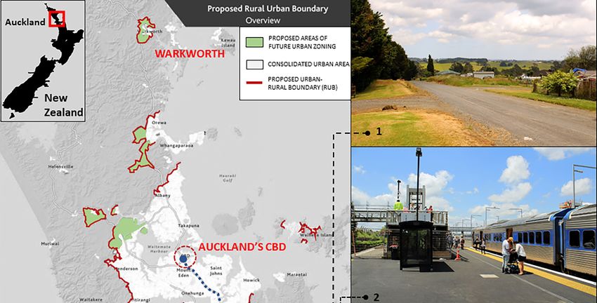
Urban Sci. 2019, 3, 1                                                                             4 of 20

Larger peri-urban areas can include towns and villages within an urban agglomeration. Such areas are
often fast changing, with complex patterns of land use and landscape, fragmented between local or
regional boundaries” [10,29].
      In many cases, the peri-urban space changes rapidly because of the population and employment
growth and spatial re-structuring triggered by new infrastructure. However, in other cases, it is
carefully managed and preserved [29]. Successful management is a difficult proposition, considering
that urban growth is not always well provided with services and infrastructure. This is the case
for Latin American and Asian cities, for instance, in which almost purely residential urban growth
configures distinctive (sub)urban landscapes. As García-Ayllón argues, “the capacity to ‘digest’ this
growth by large cities of Asia and Latin America has been limited. This phenomenon is the basis of
the configuration of new patterns of urban development and landscape settings, ranging from the
introduction of simplistic and repetitive patterns in Mexico City to the sudden creation of new cities
with skyscrapers in China” [30]. This is partly supported by empirical studies in Chinese cities that
have concluded that planning is strongly correlated withm urban sprawl patterns [31]. In a different
vein, but still stressing the idea that urban sprawl is an ambiguous, diverse and contested geographical
space, some authors have illustrated how capitalist policies have influenced suburbanization in Eastern
European cities, and contributed to the general economic growth and increments of infrastructure.
However, at a regional and metropolitan scale, the same growth has translated spatially into the
creation of segregated suburban areas, the emergence of peri-urban “ghettos” and other expressions of
socio-territorial disparity [32].
      As a dynamic process, urban sprawl describes different configurations over time. It can manifest
as different levels of land fragmentation, functionality and spatial diversity, even within the same
urban region [29]. This heterogeneity can be seen as an advanced process of suburbanization
characterized by increasing functional self-sufficiency, concentration of employment and a certain
degree of disconnection from traditional urban centres [33]. Similarly, contemporary peri-urban
boundaries appear as scenarios for emerging patterns of “polycentricism” that attract population and
employment growth [34]. At a regional scale, the term “multi-functionality” describes sprawling and
peri-urban areas as a complex mix, where different urban activities are linked to rural functions [2].
These spaces are more multifaceted—beyond residential land-uses—and include conurbation zones
and satellite towns as part of wider urban–regional systems [35]. This varied character of urban sprawl
is seen as an outcome of advanced capitalist processes where asymmetric institutional relations delay
planning reactions and leave instruments of control lagging behind de facto situations [36]. In this
context, successful land management relies on individual leadership rather than technical solutions or
macro-scale plans that often encourage urban sprawl by omission [37]. Indeed, anti-growth narratives
view sprawl as “unplanned”, evincing its unintended nature driven by unforeseen forces [38].
Therefore, a closer inspection of planning instruments is needed to provide a clearer understanding
of the extent to which urban sprawl is implicitly driven by the very same instruments that aim to
control it.

2.2. Urban Sprawl, Its Rural Dimension, and Planning Policies of Control
     Empirical studies suggest that causes of urban sprawl are mainly linked to housing policies,
land market constraints and infrastructure [39]. These studies, however, are limited to European and
monocentric city models characterized by clear relations between land fragmentation, land prices
and income growth [40]. Social factors such as rates of crime in central areas and the proximity of
rural lands to urban markets also encourage disperse suburbanization [41]. Whatever the case, the
following planning determinants are clearly identified in the literature as encouraging urban sprawl:
regional transport infrastructure and the persistence of the so-called “suburban dream” [20]; cheap
prices for rural land [11]; implementation of “urban limits” (and other urban growth restrictions) [3];
conurbation zones [42]; the absence of urban regeneration and resilience policies [43]; weak taxation
measures on empty (undeveloped) lands [44]; and institutional asymmetries between urban and rural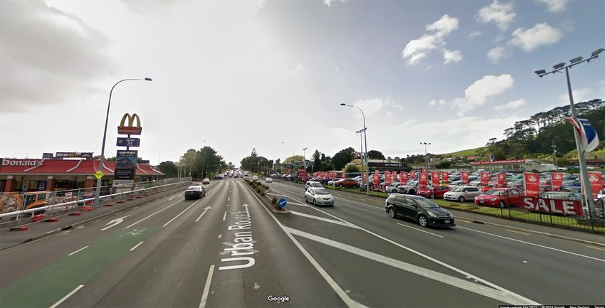
Urban Sci. 2019, 3, 1 5 of 20
representation [45]. The last determinant (i.e., the asymmetric rural–urban relationship) entails further
exploration in terms of suburban governance specifically related to the potential autonomy of the
peri-urban space
Urban Sci. 2018, 2, x and the institutional
FOR PEER REVIEW scope required to harmonize urban and rural interactions. 5 of 21
The persistent focus on discussing urban sprawl as an “urban” phenomenon is another constraint
The persistent
on comprehending thefocus
natureonof discussing urban sprawl
sprawl. Traditionally, as an “urban”
the built-up geographyphenomenon
of sprawl isis seen
another
as the
constraint on comprehending the nature of sprawl. Traditionally, the built-up geography
main object of inspection, as it reflects the forces behind the production of space [46]. However, the of sprawl
is seen as the fragmentation
morphological main object of inspection, as it reflects
of urban sprawl cannotthe forces behind
be considered the production
without reference of to space [46]. of
the series
However, the morphological fragmentation of urban sprawl cannot be considered
interstitial spaces that lie between developments, in which rural areas appear as a contested field ofwithout reference
to the series
political, social,ofenvironmental
interstitial spaces
and that lie between
economic benefitsdevelopments, in which
[47]. This is partly ruralsuburban
because areas appear
ruralas a
lands
contested field of political, social, environmental and economic benefits [47]. This
do not present major physical restrictions to urbanization, and, at the same time, their condition as is partly because
suburban
open space rural lands doasnot
is perceived present major
undeveloped or physical restrictions
simply inert to urbanization,
[2]. In this vein, differingand, at the same
positions are time,
driven
their condition as open space is perceived as undeveloped or simply inert [2]. In this vein, differing
by views of suburban rural lands as scenarios for densification or preservation [48]. In terms of the
positions are driven by views of suburban rural lands as scenarios for densification or preservation
preservation of suburban rurality, debates on peri-urbanization and the configuration of fringe/belt
[48]. In terms of the preservation of suburban rurality, debates on peri-urbanization and the
areas create practical difficulties in delimitating “the urban” [49].
configuration of fringe/belt areas create practical difficulties in delimitating “the urban” [49].
A few successful attempts to integrate “the urban” and “the rural” are currently framed by some
A few successful attempts to integrate “the urban” and “the rural” are currently framed by some
macro-scale plans, such as the “Five-Finger Plan” of Copenhagen [50] and the “Green-Heart” project
macro-scale plans, such as the “Five-Finger Plan” of Copenhagen [50] and the “Green-Heart” project
in the Netherlands [51]. In these plans, the open countryside is integrated into the urban scope in
in the Netherlands [51]. In these plans, the open countryside is integrated into the urban scope in
different
differentways.
ways. In thecase
In the caseofof Copenhagen,
Copenhagen, its morphological
its morphological definition
definition allowsallows the alternation
the alternation of built- of
built-up
up areas areas
withwith“open “open wedges”.
wedges”. The inclusion
The inclusion of nature
of nature andrural
and the the rural
spacespace as valuable
as valuable assets assets
has
has consolidated long-term territorial policies where “the rural” appears
consolidated long-term territorial policies where “the rural” appears as embedded within as embedded within “the
“the
urban”
urban” [25,26],
[25,26],configuring
configuringa acomplex
complexperi-urban
peri-urbanspace
spacemanifested
manifestedas asboth
bothasasexternal
externaland andinternal
internal to
the
tocity
the (Figure
city (Figure2). 2).
Figure2. 2. Map
Figure Map and
and diagrams
diagrams ofof greater
greater Copenhagen.
Copenhagen. (left)(left)The
Theoriginal
originalplan
planillustrating
illustratingthethe
morphological analogy of a “hand with fingers”. (middle) An abstraction of the generalurban
morphological analogy of a “hand with fingers”. (middle) An abstraction of the general urbanform
form
composed of “open wedges” and densified corridors. (right) A map of Copenhagen (Author’s
composed of “open wedges” and densified corridors. (right) A map of Copenhagen (Author’s image). image).
TheRandstad
The Randstadzonezone in the
theNetherlands
Netherlandsis isanother case-in-point.
another This This
case-in-point. is a regional urbanized
is a regional area
urbanized
morphologically
area morphologically configured
configuredas aas“ring” composed
a “ring” composed of the main
of the cities
main of of
cities Rotterdam,
Rotterdam, The
TheHague,
Hague,
Amsterdam
Amsterdam andUtrecht,
and Utrecht,and
andseveral
severaltowns
towns in
in between. These
Theseurban
urbanareas
areascircumscribe
circumscribea large
a largepiece
piece
of countryside known as the “Green-Heart”, which supports agricultural production.
of countryside known as the “Green-Heart”, which supports agricultural production. Furthermore, Furthermore,
betweenthe
between thecities
citiesand
andtowns
towns there
there are
are several
several small-scale
small-scale rural
rural spaces
spacesthat
thathost
hostagricultural
agricultural and
and
public activities including parks, urban farmlands and ecological reservoirs (Figure 3).
public activities including parks, urban farmlands and ecological reservoirs (Figure 3). In this case, In this case,
boththe
both thepublic
publicand
and private
private sectors
sectorsvalue
valuewell-located rural
well-located spaces
rural andand
spaces keep themthem
keep as mechanisms
as mechanismsfor
land-value capture, and as attractors of services and transport infrastructure [52,53]. These
for land-value capture, and as attractors of services and transport infrastructure [52,53]. These two two scales
differ in terms of planning regulations. While conurbation zones are flexible in promoting new
scales differ in terms of planning regulations. While conurbation zones are flexible in promoting
developments, the Green-Heart is strongly regulated. The key planning principle is that natural
new developments, the Green-Heart is strongly regulated. The key planning principle is that natural
landscapes are “infrastructures” that deserve a similar status as bridges, motorways or residential
landscapes are “infrastructures” that deserve a similar status as bridges, motorways or residential
neighbourhoods. This means that rural spaces dispute their position in the planning agenda at the
neighbourhoods. This means that rural spaces dispute their position in the planning agenda at the
same level as traditional infrastructure, and are equally recognized as “landmarks” along with other
outstanding architectural buildings. Indeed, the national planning policy recognizes 35 icons of
Dutch spatial planning, and 17 of them are rural landscapes [54].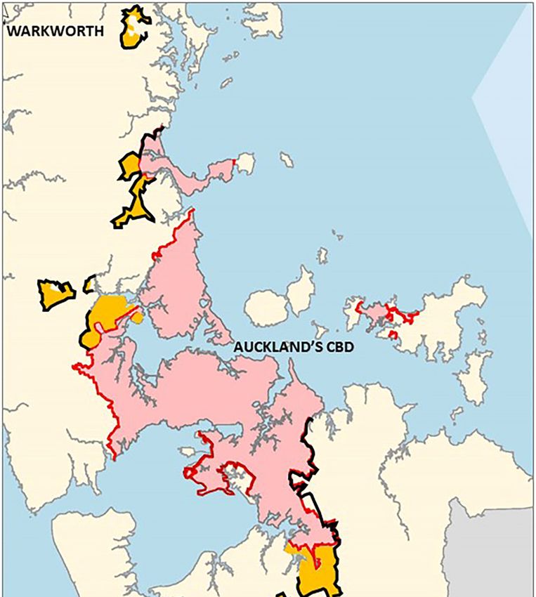
Urban Sci. 2019, 3, 1 6 of 20
same level as traditional infrastructure, and are equally recognized as “landmarks” along with other
outstanding architectural buildings. Indeed, the national planning policy recognizes 35 icons of Dutch
spatial planning,
Urban Sci. 2018, 2, x and 17 ofREVIEW
FOR PEER them are rural landscapes [54]. 6 of 21
Figure3. 3.Map
Figure Mapand
anddiagrams
diagramsof ofRandstad
Randstad zone.
zone. (left)
(left) The
Theoriginal
originalplan
planillustrating
illustratingthe
the“ring-city”.
“ring-city”.
(middle)An
(middle) An abstraction
abstraction of
ofthe
thegeneral urban
general formform
urban composed of the of
composed urbanized ring and ring
the urbanized the “Green-
and the
Heart”. (right)(right)
“Green-Heart”. Map ofMap
the Randstad zone (Author’s
of the Randstad image). image).
zone (Author’s
Despite
Despitethese
theseexamples,
examples,there
there is
is no
no agreement
agreement on on the
the extent
extenttotowhich
whichprotected
protectedrural
rural lands
lands areare
theoutcome
the outcomeofofwell-defined
well-definedplanning
planning frameworks,
frameworks, or or random
random restrictions
restrictionsderived
derivedfrom
fromphysical
physical
constraints
constraints [49].
[49]. ForFor
some,some, the “open
the “open wedges” wedges” of thePlan
of the Finger Finger Plan morphological
are mere are mere morphological
coincidences
coincidences
determined bydetermined
geographical by and
geographical
physical and physical impediments
impediments to urbanization
to urbanization (i.e., flood
(i.e., flood areas areas
and others).
and others). In any case, these examples highlight the planned and unplanned nature
In any case, these examples highlight the planned and unplanned nature of suburban rurality regardless of suburban
ofrurality regardless
its intrinsic of its intrinsic
environmental environmental
value and the ecological value and the
content ecological
associated withcontent associated
prospects with
for ecological
prospects for [54].
modernization ecological modernization
It is clear [54]. It is clearattempts
that these comprehensive that these
arecomprehensive attempts
not standard practice are not
in planning,
standard practice in planning, and suburban rural lands are constantly subdued
and suburban rural lands are constantly subdued by urbanization. This confirms the pending nature of by urbanization.
This confirms
suburban theaspending
rurality, well as nature of suburban
the “muddling rurality,
through” as wellinaswhich
rationale the “muddling
suburbanthrough”
sprawl isrationale
constantly
in which suburban sprawl is constantly constituted case-by-case.
constituted case-by-case.
3. 3. Methodology
Methodology
Thematerial
The materialpresented
presented inin this
this paper
paper is
is the
the outcome
outcome of of aa qualitative
qualitativeresearch
researchstudy
studyaimed
aimed at at
explaining the role of urban and rural policies in promoting Auckland’s urban sprawl. The sprawling
explaining the role of urban and rural policies in promoting Auckland’s urban sprawl. The sprawling
condition of the city is usually denied, or at least absent from planning narratives, as it carries
condition of the city is usually denied, or at least absent from planning narratives, as it carries negative
negative connotations usually linked to developing countries or inefficient planning regimes mainly
connotations usually linked to developing countries or inefficient planning regimes mainly dominated
dominated by market trends [10]. Indeed, Auckland is usually portrayed as one of the most livable
by market trends [10]. Indeed, Auckland is usually portrayed as one of the most livable cities in the
cities in the world in mass media rankings, clearly obscuring structural indicators for quality of life
world in mass media rankings, clearly obscuring structural indicators for quality of life linked to social
linked to social and economic issues [55,56]. For instance, Auckland is one of the least affordable cities
and economic issues [55,56]. For instance, Auckland is one of the least affordable cities in the world for
in the world for home ownership [57], and has one with the highest rates of car dependency, low use
home ownership
of public [57],and
transport andcritical
has one with thewith
problems highest rates ofcongestion
motorway car dependency, low
[58]. The usealso
city of public
sufferstransport
from a
and critical problems with motorway congestion [58]. The city also suffers from
longstanding housing shortage [11], low-quality housing, increasing rates of socio-residential a longstanding
housing shortage
segregation, and [11], low-quality
socio-territorial housing,that
disparities increasing rates
consolidate of socio-residential
longstanding patterns ofsegregation, and
gentrification
socio-territorial disparities that consolidate longstanding patterns of gentrification [59].
[59]. These factors are to a great degree embedded in planning ambiguities, as they enable traditional These factors
areurban
to a great
sprawldegree embedded
and its in planning
consequences. ambiguities,
Considering as they enable
this, a qualitative traditional
approach urbantosprawl
is adopted examine and
itsplanning
consequences. Considering
narratives and policythis, a qualitative
conflicts that giveapproach is adopted extended
effect to Auckland’s to examine planning narratives
suburbanization and
andits policy conflicts that give effect to Auckland’s extended suburbanization and its consequences.
consequences.
3.1. Context
3.1. ContextofofAnalysis
Analysisand
andthe
theCase
CaseStudy
Study
Auckland
Aucklandisisthe largest city
the largest cityininNewNew Zealand,
Zealand, with
with 1.4 million
1.4 million residents.
residents. It is located
It is located in the
in the North
North Island,
Island, and is and is recognized
recognized as the fastest-growing
as the fastest-growing region
region in the in the
country [60].country
The city [60]. The city is
is characterized
characterized
as an attractorasofan attractor
business, of business,
tourists tourists
and migrants, andand migrants, and
for contributing for the
almost contributing almost the
40% of the country's
40%
GDPof the
[61].country’s GDP [61].
It is important It isthat
to note important to is
Auckland note that Auckland
currently is currently
a metropolitan region a metropolitan region
formed by several
districts under a relatively new umbrella regulation. In 2009, Auckland underwent a major reform in
governance through the amalgamation of eight territorial authorities. The purpose was to centralize
decision-making, avoid fragmentation of governance and generate a more integrated planning
framework to deliver transport infrastructure, improve community engagement and optimize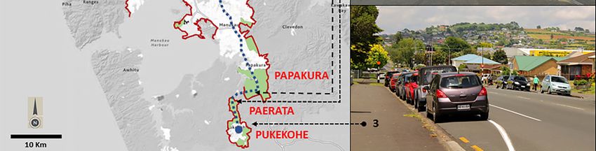
Urban Sci. 2019, 3, 1                                                                                              7 of 20

formed by several districts under a relatively new umbrella regulation. In 2009, Auckland underwent
a major reform in governance through the amalgamation of eight territorial authorities. The purpose
was to centralize decision-making, avoid fragmentation of governance and generate a more integrated
planning
  Urban Sci.framework
             2018, 2, x FORto deliver
                            PEER      transport infrastructure, improve community engagement and optimize
                                  REVIEW                                                                    7 of 21
consenting processes [62,63]. This reform defined one unitary authority, one regional council (the
  consenting
Auckland         processes
             Council),    and[62,63].  This reform
                                one integrated       defined
                                                 planning      one unitary
                                                            framework      authority,
                                                                       based          one regional
                                                                               on one spatial         council (the
                                                                                              plan (strategic  plan)
  Auckland     Council),    and  one integrated  planning   framework  based  on one spatial plan
and one district plan (statutory development control plan). In this context, the Franklin District(strategic plan)in
  and one district plan (statutory development control plan). In this context, the Franklin District in the
the south was included to contribute to regional development through its high agricultural capacity,
  south was included to contribute to regional development through its high agricultural capacity, as
as it produces most of the vegetables in the region [13]. This is relevant, as at the same time, the
  it produces most of the vegetables in the region [13]. This is relevant, as at the same time, the Franklin
Franklin District was targeted to receive the largest level of population growth linked to improvements
  District was targeted to receive the largest level of population growth linked to improvements in
in transport infrastructure and the location of new housing developments. Although its sprawling
  transport infrastructure and the location of new housing developments. Although its sprawling
character can be observed in all directions, Auckland’s sprawl is particularly apparent in the ongoing
  character can be observed in all directions, Auckland’s sprawl is particularly apparent in the ongoing
suburbanization of the Franklin District, and specifically of Pukekohe, a small town surrounded by the
  suburbanization of the Franklin District, and specifically of Pukekohe, a small town surrounded by
most
  the fertile
        most lands
               fertileoflands
                          the whole
                                of theregion,
                                        wholesituated
                                                region, 50  km from
                                                         situated 50 Auckland’s   CBD. Pukekohe
                                                                     km from Auckland’s       CBD. isPukekohe
                                                                                                       incorporated
                                                                                                                 is
into  the Auckland       Unitary   Plan  as a satellite town,  and most  of its surrounding
  incorporated into the Auckland Unitary Plan as a satellite town, and most of its surroundinglands   are zoned
                                                                                                             landsfor
housing   intensification
  are zoned    for housing (Figure     4) [60].(Figure 4) [60].
                               intensification

        Figure
      Figure 4. 4.
                MapMapofofAuckland,
                           Auckland,its
                                      itsurban
                                          urbanboundaries
                                                boundaries and future
                                                               future areas
                                                                      areas of
                                                                            of expansion
                                                                               expansion(Author’s
                                                                                         (Author’smap
                                                                                                   mapand
                                                                                                       and
        photos,  October  2017).
      photos, October 2017).

       Accordingtotothe
     According         thePukekohe
                            PukekoheArea
                                       AreaPlan
                                             Plan [64],
                                                  [64], the Franklin
                                                             Franklin Local
                                                                       LocalBoard
                                                                               Boardisisable
                                                                                           abletotoprovide
                                                                                                    providedirection
                                                                                                               direction
  on  zoning  and  urban   limits on the basis that “Pukekohe     will be a vibrant    and  dynamic
on zoning and urban limits on the basis that “Pukekohe will be a vibrant and dynamic satellite         satellite town
                                                                                                                    town
  offering
offering   a rangeofofemployment
         a range        employmentand  andresidential
                                            residential opportunities,
                                                         opportunities, with
                                                                          withexcellent
                                                                                   excellenttransport
                                                                                              transportconnections,
                                                                                                          connections,
  infrastructure,open
infrastructure,    open space
                          space and
                                  and recreation
                                       recreationfacilities,
                                                   facilities,and a thriving
                                                                and  a thriving locallocal
                                                                                       economy”
                                                                                            economy”[64] (p.
                                                                                                          [64]09).
                                                                                                                (p.The09).
The proposed zoning is intended to support housing increments (i.e., special housing areas,single
  proposed    zoning   is intended    to support   housing    increments    (i.e.,  special  housing    areas,     single
  housing
housing     areas,mixed
         areas,    mixedhousing
                            housingareas,
                                     areas,mixed
                                            mixed housing
                                                   housing suburban,
                                                              suburban, and
                                                                          andterrace
                                                                                 terracehousing
                                                                                          housingapartments)
                                                                                                     apartments)   and
                                                                                                                     and
  general  growth   outcomes    for Auckland   (Figure
general growth outcomes for Auckland (Figure 5).        5).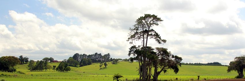
Urban Sci. 2019, 3, 1 8 of 20
Urban Sci. 2018, 2, x FOR PEER REVIEW 8 of 21
Figure
Figure 5. Map
5. Map of Pukekohe
of Pukekohe and its proposed
and its proposed land uses Council.
land uses (Auckland (Auckland Council. Pukekohe-Paerata
Pukekohe-Paerata Structure
PlanStructure
Process. Plan Process.
September September
2017. Copyright2017. CopyrightCouncil,
© Auckland © Auckland Council,
Auckland. Auckland.
New New Zealand).
Zealand).
3.2.3.2.
Methods andand
Methods Materials
Materials
TheThestudy on which
study on which thisthis
paperpaperis based included
is based includedinterviews with
interviews keykey
with stakeholders,
stakeholders, sitesite
visits,
visits,
spatial analysis and policy analysis [65]. Twenty-three semi-structured interviews
spatial analysis and policy analysis [65]. Twenty-three semi-structured interviews [66] were [66] were conducted
in 2017 with planners,
conducted policy-makers,
in 2017 with members of local
planners, policy-makers, boardsof
members and theboards
local Auckland
and Council, real-estate
the Auckland Council,
developers,
real-estate consultants
developers, inconsultants
urban design, residents
in urban andresidents
design, landowners. The stakeholders
and landowners. were selected
The stakeholders were
for their first-hand knowledge of Auckland’s urban policy, the area of analysis
selected for their first-hand knowledge of Auckland’s urban policy, the area of analysis or theiror their involvement in
planning at different
involvement levels. The
in planning interviews
at different were
levels. Theanonymized
interviews so thatanonymized
were the respondents could
so that be frank,
the respondents
without
couldfear of professional
be frank, without fearrepercussions.
of professional repercussions.
SiteSite
visits were undertaken
visits were undertaken in the
in thesecond
secondhalf of of
half 2017
2017toto
observe
observethetheperi-urban
peri-urbanspacespacesubject
subject to
to housing intensification. They provided visual documentation
housing intensification. They provided visual documentation of and information on of and information on thethespatial
spatial
composition of the area, its physical infrastructure, agricultural activities, ongoing
composition of the area, its physical infrastructure, agricultural activities, ongoing urbanization, urbanization,
accessibility
accessibility andandlandscape
landscape quality.
quality. TheThematerial
materialgathered
gatheredenabled
enabledspatial
spatialanalysis
analysisand andappraisal
appraisal of
of the
the physical
physical landscape
landscape and and its
itsinfrastructure.
infrastructure.The Theinformation
information waswas clustered
clustered and and collated
collated with
with policy
policy reports.
reports.
It isIt important
is important to note
to notethatthat
for for
thisthis
paper, mainly
paper, focused
mainly on on
focused the the
analysis
analysisof key
of keyplanning
planning
documents [65], only a fraction of the empirical information was used,
documents [65], only a fraction of the empirical information was used, and it was collated and it was collated with with
statistical data from official databases. The documents analysed were the Addendum
statistical data from official databases. The documents analysed were the Addendum to the Draft to the Draft
Auckland Unitary Plan [67], the Rural Urban Boundary Report [68], the Rural Production report [69],
the Capacity for Growth Study [70], the Pukekohe Area Plan [64], the Auckland Council District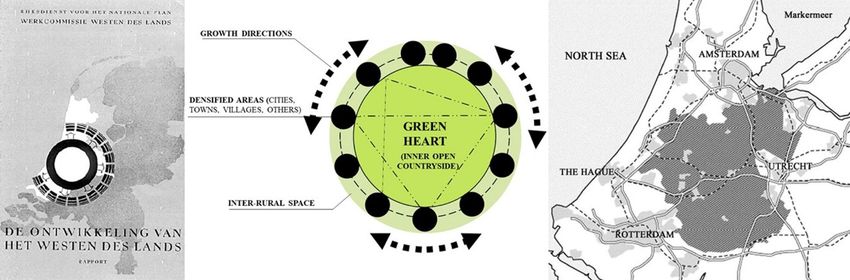
Urban Sci. 2019, 3, 1                                                                                      9 of 20

Auckland Unitary Plan [67], the Rural Urban Boundary Report [68], the Rural Production report [69],
the Capacity for Growth Study [70], the Pukekohe Area Plan [64], the Auckland Council District
Plan—Operative Franklin Section [60], the Future Urban Land Supply Strategy [71] and the Auckland
Plan [72]. Document analysis also included secondary research, masterplans and urban design
proposals, and relevant news articles related to the Pukekohe area (Table 1).
     The limitations to this research included the lack of secondary material on Pukekohe from
an urban planning perspective. However, this gap was balanced by environmental studies on the
agricultural attributes of the area, already menaced by urban expansion. The research was also limited
by constraints on accessing a whole range of private properties located at the conurbation between
Auckland and Pukekohe. However, these lands are able to be seen from outside as there are no major
visual restrictions. Thereby, visual records were made to overcome the lack of access, specifically
through photographs that were useful for assessing the spatial characteristics of these lands.

                             Table 1. Selected documents and main content analysed.

                  Analysed Documents
                                                                          Contents Analysed
            (Main Policy Reports and Studies)
                                                         Description of the Franklin District regarding
            (1) Auckland Council District Plan.
                                                         population growth, definition of urban areas, natural
           Operative Franklin Section, 2000. [60]
                                                         character, and cultural heritage.
                                                         Description of the Pukekohe plan for urban growth
 (2) Pukekohe Area Plan. Auckland Council, 2014 [64]     and its implications for community engagement,
                                                         economic growth, transport and natural environment.
                                                         Definition of the Rural-Urban Boundary (RUB) and
   (3) Addendum to the Draft Auckland Unitary Plan.
                                                         associated planning tools for enabling affordable
      Auckland Council (2013a). 15 March 2013 [67]
                                                         neighbourhoods.
  (4) Auckland Unitary Plan – Rural Urban Boundary.
     Discussion Paper. Transport Issues. Auckland        Estimated growth in greenfield areas for investigation.
  Strategy & Research Department. Auckland Council.      Location of the RUB and transport infrastructure.
             Auckland, New Zealand. [68]
     (5) Rural production. Comparative analysis.
                                                         Comparative analysis of rural productivity between
    Greenfield Study Areas. North, North-West and
                                                         selected greenfield areas in northern and
  South Auckland. Primary Focus. Auckland Council,
                                                         southern Auckland.
                      2013 [69]
                                                         Monitoring of residential, business and rural land
    (6) Capacity for Growth Study 2013 (Proposed
                                                         availability. This evaluates the residential capacity,
  Auckland Unitary Plan): Results. Auckland Council,
                                                         limitations for residential growth including the main
                       2013 [70]
                                                         urban area and also rural towns.
                                                         This strategy identifies a program to sequence future
   (7) Auckland Future Urban Land Supply Strategy.
                                                         urban land over 30 years and assists with the ongoing
             Auckland Council, 2017 [71]
                                                         supply of greenfield land for development.
                                                         The main planning document that provides policy
                                                         orientations regarding urban growth, greenfield
                                                         developments, rural development, infrastructure,
    (8) The Auckland Plan. Auckland Council, 2018.
                                                         community engagement, cultural (Maori)
              ISBN 978-0-473-21410-4 [72]
                                                         development, recreational and sport policies,
                                                         historical heritage, economic growth, environment,
                                                         housing and transport.

4. Results

4.1. Auckland’s Urban Sprawl
     Two factors discussed in relation to Auckland’s urban sprawl are the increasing population
rate and improvements to transport infrastructure [67,68]. Recognized as one of the most important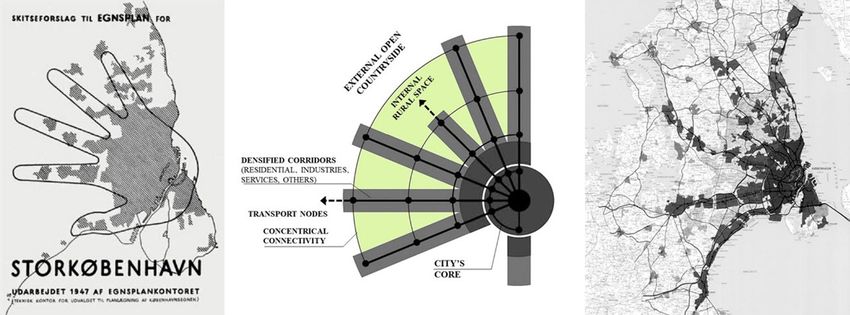
Urban Sci. 2019, 3, 1                                                                                10 of 20

urbanized areas of the entire Pacific Rim [72], Auckland hosts one-third of New Zealand’s population.
It is expected that over the next 30 years, Auckland will experience 60% population growth, increasing
from 1.4 million to 2.3 million people, mainly fuelled by natural growth and both internal and overseas
migration [61].
       During the past 20 years, Auckland has evolved from a traditional agglomeration of suburban
districts towards an amalgamated metropolitan entity regulated by a general framework plan,
“The Auckland Unitary Plan” [64]. The plan contemplates new zones of expansion beyond consolidated
areas, but simultaneously advocates for a “compact city model”, indicating that 70% of future urban
development will be placed within urban boundaries [67]. Despite this, projections indicate that
future urban expansion will be the main trend and will comprise at least four zones: urban, suburban,
peri-urban and ex-urban—configuring a more detailed urban–rural transect and confirming the
character of Auckland as a city-region [73]. As previously commented, these categories differ in
terms of function, geographical location, spatial configuration and functional relationship with
the consolidated city. However, the planning tools that operate in these zones are similar, and
as a result the morphological pattern is relatively homogeneous. This sprawling geography is
characterized by traditional low-density residential developments that extend over the countryside
without acknowledging any functional or spatial variation regarding proximity to the city or the
countryside [15]. Ongoing urbanization plans indeed confirm that projected urban forms will be the
same all across the peri-urban space (Figure 6). As a control measure, ex-urban development is limited,
with the exception of the selected locations of Warkworth in the north and Pukekohe in the south, both
surrounded
Urban Sci. 2018,by
                2, xagricultural and environmental assets [67–69].
                     FOR PEER REVIEW                                                            11 of 21

             6. Planned
      Figure 6. Planned suburbanization
                        suburbanization between
                                        between southern
                                                southern Auckland
                                                         Auckland and
                                                                  and Pukekohe (Author’s
                                                                               (Author’s photo,
                                                                                         photo,
      November 2017).

      The
      The sprawling character of
          sprawling character  of Auckland
                                  Auckland hashas gained
                                                  gained momentum
                                                           momentum in in light
                                                                           light of
                                                                                 of housing
                                                                                    housing affordability,
                                                                                              affordability,
car
car dependency,
    dependency,socio-environmental
                  socio-environmentalimpacts
                                         impactsof of
                                                   disperse urbanization
                                                      disperse             andand
                                                                urbanization    infrastructural  needs
                                                                                    infrastructural    [74].
                                                                                                     needs
Supposedly,   urbanization  beyond    the  consolidated   area  should  improve     housing   affordability.
[74]. Supposedly, urbanization beyond the consolidated area should improve housing affordability.
However,
However, Auckland
           Auckland does
                      does not
                           not describe
                                describe aa typical
                                             typical economic
                                                      economic geography
                                                                 geography where
                                                                              where outer
                                                                                     outer lands
                                                                                            lands become
                                                                                                   become
automatically  cheaper.  The  factors  that distort the  typical reduction   of land  prices closer
automatically cheaper. The factors that distort the typical reduction of land prices closer to       to the
                                                                                                        the
countryside relate to a series of natural amenities (e.g., beaches, forests and parks) that influence land
prices. Additionally, urban limits and other growth restrictions do not include methods of land-value
capture for regressive investment [3]. This is more critical considering that the meaning of
“affordability” is still under debate in current New Zealand legislation [12]. Indeed, the Auckland
Plan states that “there is no agreed definition or measure of ‘affordable’ or ‘unaffordable’ housing”
Urban Sci. 2019, 3, 1 11 of 20
countryside relate to a series of natural amenities (e.g., beaches, forests and parks) that influence
land prices. Additionally, urban limits and other growth restrictions do not include methods of
land-value capture for regressive investment [3]. This is more critical considering that the meaning of
“affordability” is still under debate in current New Zealand legislation [12]. Indeed, the Auckland Plan
states that “there is no agreed definition or measure of ‘affordable’ or ‘unaffordable’ housing” [72]
(p. 269), but nevertheless indicates that housing affordability is a priority considering “the housing
crisis” [72] (p. 269). It is well-known that Auckland has the highest price-to-rent ratio and the second
highest price-to-income ratio of the OECD countries [75]. Thus, the release of land in the peri-urban
space—particularly within the so-called “Rural–Urban Boundary” (RUB)—would ensure enough
development capacity, as the value of land within the limits is around nine times higher than prices
just outside them [12,73]. Despite their impacts, the determinants that explain Auckland’s sprawl are
seen simply as factors that cannot be controlled by planning policies, and as natural constraints of
neoliberal regimes that cannot harmonize economic growth with environmental protection [76].
4.2. Auckland’s Peri-Urban Space, the RUB and Their Ambiguities
Along with other Australasian cities and as previously discussed, Auckland’s peri-urban space is
defined as the interface between the city and the countryside. However, this is ambiguous considering
that the urban–rural interface takes varied forms in terms of land uses and morphological aspects,
making it difficult to identify where this peri-urban space is located, or where the city ends and the
countryside starts [77]. In the case of Auckland, the “Rural–Urban Boundary” (RUB) is a planning
scheme aimed at fixing the geography of this urban–rural interface, establishing future areas for
expansion and restrictions on growth. More specifically, the RUB is a planning tool—part of the
Auckland Unitary Plan—that defines the extent of urban development to 2041, and areas to be kept as
rural. Its purpose is to achieve efficient urban development and the conservation of the countryside
and its productive rural soils. The RUB also defines the available space for the sequenced provision of
infrastructure to support growth and urban development in existing urban and greenfield areas [68].
The RUB replaced the “Metropolitan Urban Limit” (MUL) in 2010. The abolition of the MUL was
due to a series of land-price distortions triggered by zoning decisions linked to the location of the
MUL. As with most urban limits, the MUL operates via the definition of a boundary that determines
the inclusion of new rural lands for urbanization. This is common in cities where traffic externalities
are unpriced. In the case of Auckland, land immediately to the inward side of the boundary was
valued at a higher rate per hectare than land immediately on the outward side of the boundary.
Furthermore, the MUL was considered inappropriate, as it was a response to an idealized monocentric
city model that does not reflect Auckland’s morphological and functional characteristics. Auckland is
increasingly described as polycentric, and thus not suitable for the simple application of growth
restrictions such as the MUL [3]. Therefore, the RUB emerged to define a hybrid (urban–rural) zone
complemented by infrastructure and services [3]. Nevertheless, this replacement did not address the
planning ambiguities previously defined by the MUL, and opened up new uncertainties related to its
still prescriptive character.
The Auckland Plan clearly indicates that—through proposed growth zones—the RUB provides
flexible conditions to allow up to 40% of new homes to be built outside the urban limit in well-planned
greenfields to ensure land availability for the next 30 years [68]. This approach is designed to provide
certainty to communities, landowners, infrastructure providers and developers on where Auckland
will experience the most significant changes. For the Auckland Unitary Plan, the RUB is a geographical
space “that will define the maximum extent of urban development to 2040 in the form of permanent
rural–urban interface” [68] (p. 07), and which embraces part of the metropolitan area, rural-coastal
villages, and the satellite towns of Warkworth in the north and Pukekohe in the south.
Depending on the location, the RUB can be a simple line delimiting and consolidating areas and
their expansion, or it can circumscribe an entire new area for urban development. The new areas can
be adjacent to current consolidated zones (i.e., continuous growth), or be spatially separated from theUrban Sci. 2019, 3, 1 12 of 20
city (i.e., discontinuous growth). Figure 7 shows how the RUB in the north delimits growth areas in
the form of a line, but in Warkworth, for instance, it circumscribes almost the entire town. The same
situation applies for the west, while in the south it defines the expansion areas for Papakura and
Paerata, and circumscribes the entire town of Pukekohe and its surroundings (Figure 7).
The RUB paints an interesting picture, considering that previous tools for urban containment have
usually used two main strategies, greenbelts and urban growth boundaries [78], both characterized by
a continuous shape without gaps for urban expansion. However, the RUB offers a different approach
as a discontinuous spatial demarcation that at different points appears open or closed, depending on
the geographical
Urban andPEER
Sci. 2018, 2, x FOR functional
REVIEW purposes. 13 of 21
Figure 7. Map of the metropolitan area of Auckland showing the MUL, the RUB and areas of expansion
Figure 7. Map of the metropolitan area of Auckland showing the MUL, the RUB and areas of
(Author’s map).
expansion (Author’s map).
Another ambiguity relates to indications that the RUB is encouraging further growth in existing
Another ambiguity relates to indications that the RUB is encouraging further growth in existing
urban areas to protect the rural space. Nevertheless, the documentation also states that greenfield
urban areas to protect the rural space. Nevertheless, the documentation also states that greenfield
areas for investigation will be delineated by the RUB and thus urban boundaries can be reshaped
[24]. Furthermore, the RUB indicates that natural features will be considered only to provide well-
defined physical boundaries, mainly highlighting the spatial values of the peri-urban landscape but
clearly reducing its ecological character to elements for marketable purposes. This conceptual
reduction is relevant as it obscures the environmental damage caused by urbanization of fertile ruralUrban Sci. 2019, 3, 1 13 of 20
areas for investigation will be delineated by the RUB and thus urban boundaries can be reshaped [24].
Furthermore, the RUB indicates that natural features will be considered only to provide well-defined
physical boundaries, mainly highlighting the spatial values of the peri-urban landscape but clearly
reducing its ecological character to elements for marketable purposes. This conceptual reduction is
relevant as it obscures the environmental damage caused by urbanization of fertile rural lands [13,14].
The Auckland Plan presents further planning ambiguities when it states that urban expansion
into rural villages must “avoid urbanisation of highly productive farmland and versatile soils
where possible . . . ” [72] (p. 230), but simultaneously considers re-zoning rural lands for future
urbanization “to allow rural activities to continue until urban development can take place” [72] (p.
4). This explicitly determines the temporary character of rural and environmental assets as subject
to suburbanization over time. What is more, such ambiguities are paradoxically clear in terms of
benefits to individual landowners as they define direct transferences of wealth under discretional
decision-making. Once rural lands are transformed into urban, the plan indicates that their value will
increase with the concurrent transference of wealth to the landowner (windfall gain as an outcome of
rezoning decisions). By way of compensation, the plan also proposes that the Council should receive a
proportion of this land-value capture to re-invest in infrastructure, public works, affordable housing
or further growth [72]. However, the legal strength of this mechanism is under revision, as the Local
Government Act first has to be changed to ensure the Council’s power to implement this levy [71].
Finally, a further structural ambiguity is an institutional framework that simultaneously controls
urban development and environmental preservation: the Ministry for the Environment (MfE).
In New Zealand, urban planning and farming protection both fall under the jurisprudence of the
MfE. On the one hand, this representation exerts a strong influence in formulating policy statements,
strategies and action plans for the protection of versatile lands that are considered resources of national
importance. Fertile soils represent a small percentage of New Zealand’s land area and are considered as
a finite and ever-decreasing resource in high demand, particularly in relation to land-use activities that
are largely irreversible. It is not unusual for environmentalists to use the MfE as a platform to advocate
for a national policy on strategic land resources, including the creation of “National Food Security
Zones” of high-class land protected for exclusively soil-based food production. They argue that this
framework would give the land the same status and protection as conservation land. In a similar vein,
Horticulture [13] proposed a “Domestic Food Security Policy” to ensure the continued sustainable
local production of fresh food for the nation [13]. On the other hand, the MfE also drafts policies and
planning tools to implement urbanization using well-defined planning and urban design principles.
In 2002, for instance, the MfE published the report “People + Places + Spaces: A Design Guide for
Urban New Zealand” as the first comprehensive attempt to define urban design and its implications.
This report aimed to support high-quality planning and urban design outcomes [79] and was later
reinforced by the creation of the so-called “New Zealand Urban Design Protocol” (2005) [80]. Here,
seven essential design qualities (known as the “seven Cs”: context, character, choice, connections,
creativity, custodianship, collaboration) inform the design process and ensure the implementation
of good urban design projects. However, these reports do not acknowledge the rural character of
the country—particularly evident in the peri-urban areas—and sustain a relatively standardized
approach seen in other latitudes characterized by heavily urbanized regions, such as in the UK or the
Netherlands. The reports are all about what to do rather than what to preserve, and do not provide
clear clues on how to incorporate the evident rural identity of New Zealand into planning and urban
design theory and practice.
5. Discussion
The Expansion to Pukekohe
As mentioned, Pukekohe is a satellite town located in the Franklin District, 50 km from the
Auckland’s CBD. The area is characterized by its rural landscapes, which are already marked forYou can also read