Switzerland in space Cutting-edge research and high-tech solutions - for everyday life
←
→
Page content transcription
If your browser does not render page correctly, please read the page content below
Switzerland in space
Cutting-edge research
and high-tech solutions
– for everyday life
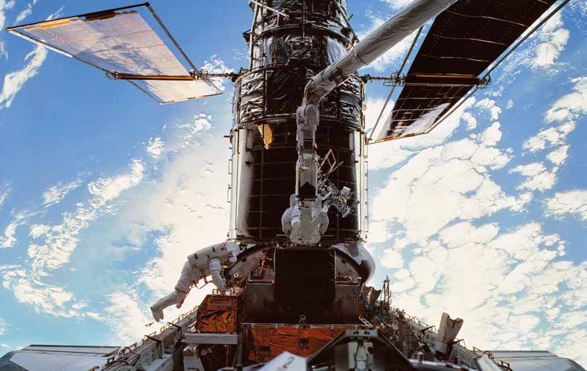
Table of Contents

        Introduction

        What is the significance of space for science, technology and industry in Switzerland?    4
        “Space is helping us understand our world better.”                                        5
        Swiss Space Policy                                                                        6
        Space adventure – selected historical Swiss contributions                                 8

        Benefits for daily life

        Reliable weather forecasts and climate data thanks to satellites                         10
        Safer landing thanks to the EGNOS satellite navigation system                            12
        Satellite data and Swiss know-how increase yields and reduce risks for rice farmers      14
        Detecting natural hazards early, thanks to satellite radars                              16

        Industry

        Space is part of daily life and an economic driver for Swiss industry                    18
        No Ariane rocket launch without Swiss hi-tech                                            20
        Swiss atomic clocks improve the accuracy of our satellite navigation systems             22

        European Space Agency

        The European Space Agency (ESA)                                                          24
        ESA chairmanship: Switzerland in charge for Europe                                       26
        A look behind the scenes at the European Space Agency (ESA)                              28

        Research and Exploration

        Switzerland on board the International Space Station (ISS)                               30
        ROSINA – Rosetta’s Swiss pearl                                                           32
        CHEOPS: A small satellite but a unique opportunity for Switzerland                       34
        An observatory for cosmic rays                                                           36
        Swiss research provides insights into space debris                                       38
        The astronaut’s view                                                                     40

                                                                                       3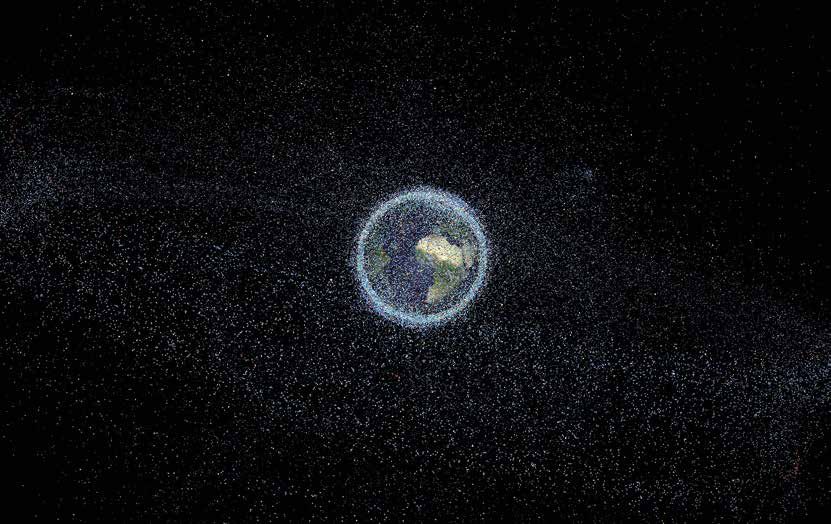
What is the significance of space
for science, technology and
industry in Switzerland?
Switzerland has been an integral and active partner It cannot be sufficiently emphasized how harsh and
in the European space adventure since its very begin- unforgiving the Space environment is. Its explo-
ning. It has been the aim of our skilled scientists and ration and exploitation pushes our scientists and
entrepreneurs to make cutting-edge science happen entrepreneurs to explore their limits. It is an excit-
and to transfer the resulting applications into the ing and challenging area with prospects that can
economy for the benefit of society. The pride we be unknown at the start in which success depends
feel of being a founding member of the European on the combination of skills and expertise to get it
Space Agency (ESA) has been equaled by our deter- right. The demand for space systems that function
mination to work even harder for the advancement reliably for years on end means that the resulting
of European space during our co-presidency togeth- technologies are the best possible, simultaneously
er with Luxemburg of ESA’s Ministerial Council from offering transfer possibilities to non-space markets.
2012 to 2016. A major highlight during this period The key to sustainable development in this sector,
was certainly the decision to develop Ariane 6 thus as in others, lies in the advancement of technology
guaranteeing the continuation of an autonomous and the innovation capacity of industry. Thanks to
European access to space at competitive conditions. the stringent requirements of space projects in all
Our commitment has led to higher political atten- aspects – from programme management to quality
tion at European, as well as at national level of what control – space industry creates jobs and growth
Switzerland does in space. well beyond the space sector itself.
Space is a global business. European States work-
ing together can and do achieve far more than any
single one actor on its own. This is why we have
chosen ESA to be our only space agency. Together
with the excellence and commitment of our space Johann N. Schneider-Ammann
community ESA has enabled Switzerland to play President of the Swiss Confederation 2016
important roles in scientific missions and industry Head of the Federal Department of Economic
consortiums. In the following pages, you will (re) Affairs, Education and Research EAER
discover the numerous Swiss and European suc-
cess stories in space through the eyes of those
who make space happen here on the ground and
of course in space, and the important contribu-
tion that science and space technologies make to
people’s lives.
Operational applications based on telecommuni-
cation, navigation and Earth observation satellites
contribute to a better understanding of our planet,
a more efficient traffic management on land, at sea
and in the air, or to bridge the digital divide, just to
name a few. The key drivers of Switzerland’s action
in space include scientific and technological pro-
gress, enabling us to not only position our coun-
try as a competitive and reliable partner in specific
niches, but also to contribute to the competitive-
ness of European space industry as a whole. One
of the striking examples are the payload fairings for
the European Ariane and Vega launchers.
4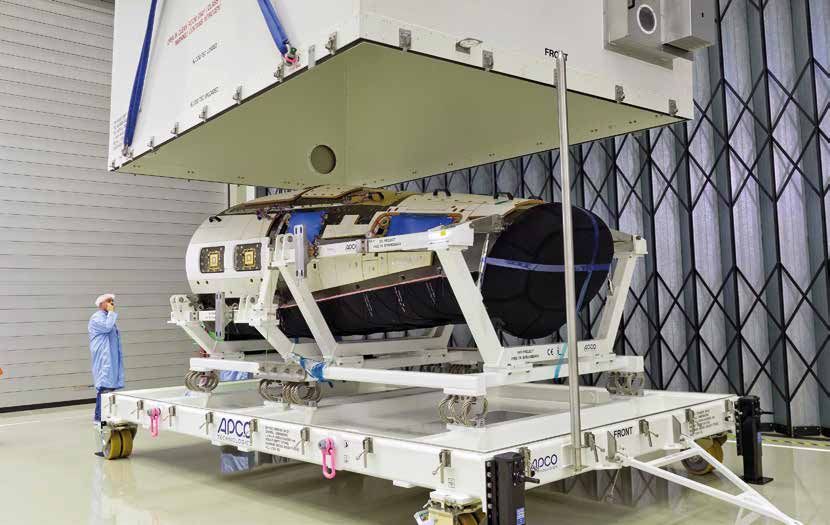
“Space is helping us understand
our world better.”

            Space has become an essential part of modern so-        For Switzerland, space is not only synonymous with
            ciety. Scientists use space missions to research the    innovation, cutting-edge technology, precision,
            universe and our solar system and its planets. Sat-     and scientific excellence, it also stands for value
            ellite-assisted communication, meteorology, nav-        creation, thanks to European and global coopera-
            igation, cartography, and earth observation have        tion. This brochure aims to present the Swiss space
            brought space into our everyday lives. They have        sector to a wider audience and show how it ben-
            given us reliable weather forecasts, safe landings,     efits us all in our everyday lives. I hope you enjoy
            functioning mobile phones and satellite navigation      reading it.
            systems, television programmes from around the
            world, and the digital revolution in photography.
            Satellites send us climate data and help us to man-
            age the risks associated with natural disasters. They
            monitor unstable mountain slopes and vulnerable
            infrastructure, helping farmers to increase yields.

            Space also plays an important role in Switzerland’s     Didier Burkhalter
            policy, from industrial and infrastructure policy to    Federal Councillor
            targeted international cooperation in Switzerland’s     Head of the Federal Department
            interest. Switzerland was a founding member of          of Foreign Affairs FDFA
            the European Space Agency (ESA). For 40 years,
            our country has been at the forefront in developing
            rockets and research programmes. We are help-
            ing to build a competitive, independent Europe in
            space that serves society and responds to its needs.
            The European satellite navigation system Galileo is
            an example of this.

            Our space policy guarantees access to space for
            science and the economy. A long series of interna-
            tional treaties and agreements ensure that we all
            have access to the resulting data. Our space policy
            is in line with our foreign policy, sharing the same
            active dedication and solidarity. In this context,
            Switzerland is committed to the peaceful, secure,
            and sustainable use of outer space. Internationally,
            it supports development of guidelines to prevent
            proliferation of space debris from becoming a
            threat to the space industry and people down on
            earth. Space technologies help us to analyse global
            problems and seek solutions in the areas of climate
            change, environmental protection, food security,
            and prevention of natural and technological disas-
            ters.

                                                                                          5
Swiss Space Policy
Space activities play an important role in Implementation
our society. Alongside their scientific contri-
butions to the exploration of Planet Earth Switzerland safeguards its national interests via
and of the Universe, they have made their chosen international collaborations, in particular
way into our daily lives: satellite telecom- through selective participation in programmes and
munication, navigation assistance on land, activities of the European Space Agency (ESA), and
sea and in the air, or even Earth observa- some further European and international space
tion from space for weather forecasts or for activities. In addition, complementary national
a better understanding of climate change activities contribute to position research institutions
have become indispensable. and industry favourably with regard to future pro-
curement opportunities in institutional European
Switzerland has been active in this fascinating programmes. They contribute to strengthen the
and demanding domain since the beginning of existing competences in established and new scien-
the space era. The country has found its place tific and technological domains.
in the European space community, and is thus in
a position to also safeguard its interests globally. It is the Federal Council that decides on the Swiss
Switzerland aims to be a serious, competitive and space policy. Such decisions are based on recom-
reliable partner. Its strong position is thanks to mendations formulated by the Federal Commission
its long-standing competences such as innovative for Space Affairs. The responsibility for preparing
capacity and precision. and implementing the national space policy lies
with the Swiss Space Office of the State Secretariat
Engaging in space constantly challenges inventive- for Education, Research and Innovation (SERI), in
ness in research and in industry. Space is a vital close cooperation and coordination with the Minis-
contribution to the prosperity of our country. It in- tries and Federal Offices which have space related
cludes activities with high added-value, which will tasks.
also be of benefit for future generations.
The Confederation creates the boundary condi-
tions to enable for Swiss actors to become success-
Principles of the Swiss space policy ful in science, research, technology and industry in
the European and international environment. How-
Switzerland is active in space, focusing on: ever, the research institutions and companies are,
together with their employees, ultimately the ones
development and exploitation of space-based creating the Swiss successes in space.
applications with the aim of improving the
quality of life for its citizens;
long-term safeguard of its commitment to
space research for the benefit of innovation
and the knowledge society;
provision of key scientific, technological, and
industrial contributions enabling the country
to position itself as a competitive, reliable, and
indispensable partner.
6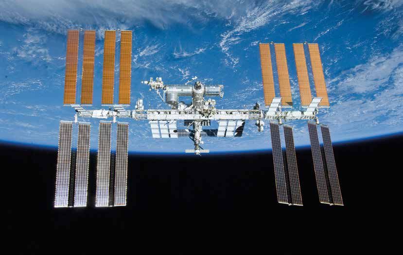
Context and main actors for Swiss space activities

                                                          FEDERAL
      INTERNATIONAL                                    ADMINISTRATION
    ORGANISATIONS AND
       PROGRAMMES                                                             RESEARCH
                                          INDUSTRY                          INSTITUTIONS

                           Thomas Hurter, member of the National Council
                           President of the Federal Commission for Space Affairs

                           „Space has become an indispensable part of our lives. Many of the daily
                           applications we use have been developed thanks only to space activities.
                           Switzerland’s participation in space programmes allows our small but highly
                           innovative country to play a leading role in the progress of science and tech-
                           nology. This is even more important because the significance of space will
                           further increase, in particular in sectors such as energy, environment, traffic,
                           transport and security.”

                                                                            7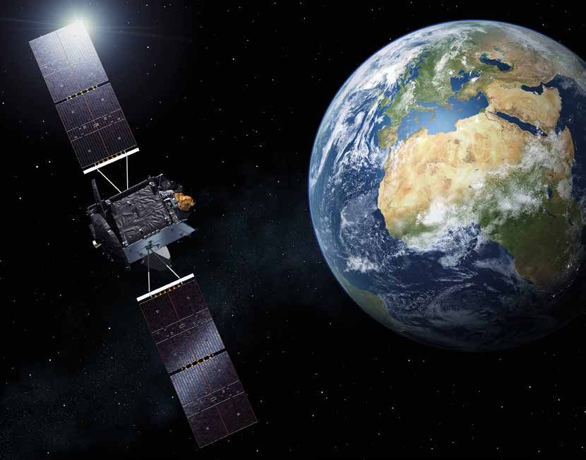
Space adventure – selected                                                                                        1960
historical Swiss contributions
                                                                                                                  Early days of European cooperation in
                                                                                                                  space: Meyrin, Switzerland – Delegates
                                                                                                                  of the Intergovernmental Conference
                                                                                                                  of Space Research. Switzerland was
                                                                                                                  among the nations that created the
                                                                                                                  European Space Research Organisation
                                                                                                                  (ESRO), one of the organisations that
                                                                                                                  paved the way for Europe to enter
                                                                                                                  space. © ESA

       1986                                          1990                                          1995

       Up close in deep space: Giotto, ESA’s         Reaching for the sun: Launch of the ESA/      Beyond our solar system: Michel Mayor
       first deep-space mission, passes closest      NASA Ulysses mission. During its almost       and Didier Queloz of the University of
       to the famous Halley’s comet with a           18 years of uninterrupted observations of     Geneva discover the first planet outside
       mass spectrometer from the University         the sun and the heliosphere, Ulysses has      the solar system in orbit around the
       of Bern on board. For the first time the      made fundamental contributions to our         nearby star 51 Pegasi. © ESA
       instrument made in situ measurements          understanding of the sun and our local
       of a comet’s dust and gas. © ESA              interstellar neighbourhood. The mission,
                                                     the longest in ESA’s history, included the
                                                     Solar Wind Ion Composition (SWICS)
                                                     instrument from Switzerland. © ESA

                      2008                                           2009–2010                                    2012

                      Onboard Columbus: SOVIM, an                    Hands-on education and training:             Protection for another European
                      instrument to observe and study                ‘Swisscube’, a cubesat, launched in          launcher: The maiden flight of the
                      the irradiance of the sun with high            2009 with the scientific aim of observ-      European Vega launcher, with its pay-
                      precision, stability and accuracy was          ing airglow, was manufactured entirely       load protected by a Swiss fairing, built
                      among the first experiments on board           in Switzerland and has enabled around        by RUAG Space. Swiss payload fairings
                      the European Columbus research                 200 students from the Swiss Federal          continue to provide reliable services on
                      laboratory attached to the International       Institute of Technology in Lausanne          board European and American launch
                      Space Station ISS. The Swiss instrument        (EPFL) and Universities of Applied           vehicles. © ESA
                      was from the Davos Physical Meteoro-           Sciences to collaborate closely. A team
                      logical Observatory. © ESA                     from the University of Applied Sciences
                                                                     and Arts of Southern Switzerland
                                                                     launched the educational Tisat-1 in
                                                                     2010. © EPFL

             8
1969                                        1975                                         1978                                         1979

From Bern to the Moon and back:             One roof for space: Creation of the          European astronaut selection: Swiss-         Launcher payload protection –
During the first landing on the Moon,       European Space Agency (ESA), of which        born Claude Nicollier is selected in the     swiss-made: The maiden flight of the
astronauts deploy the Solar Wind            Switzerland is a founding member. This       first group of ESA astronauts to fly on      European Ariane-1 launch vehicle,
experiment devised by Johannes Geiss,       was the result of a merger between           board the US Space Shuttle. Nicollier        featuring a Swiss payload fairing.
a professor at the University of Bern,      the ESRO and the European Launcher           was a crewmember on four Space               Ariane-1 was designed primarily to put
to study the sun’s continuous flux          Development Organisation (ELDO). That        Shuttle flights in 1992, 1993, 1996          two satellites into orbit at a time, thus
of charged particles or the so-called       also allowed for the scope of the new        and 1999, and logged more than 1000          reducing costs. As the size of the satel-
‘solar wind’. This experiment helped        agency’s remit to be widened to include      hours in space, including a spacewalk        lites grew, Ariane-1 began to give way
to resolve the competing theories           operational space applications systems       to install new equipment on the Hubble       to the more powerful Ariane launchers.
about the origins of the solar system,      such as telecommunications satellites.       space telescope. © ESA                       RUAG launcher fairings continue to
planetary atmospheres and solar wind        © ESA                                                                                     enjoy success for their reliability to this
dynamics. © NASA                                                                                                                      day. © ESA

               2002                                        2004                                         2008

               Launch of the most advanced gam-            Launch of Rendez-vous with a comet:          Swiss precision in space: In preparation
               ma-ray observatory INTEGRAL: The            Rosetta was the first ever spacecraft        for deployment of the Galileo System,
               International Gamma-Ray Astrophysics        designed to chase, go into orbit around,     ESA initiated development of two on-
               Laboratory (INTEGRAL) Science Data          and land on a comet. It studied the          board clock technologies in the 1990s:
               Center attached to the University of        comet 67P/Churyumov-Gerasimenko              the Rubidium Atomic Frequency Stand-
               Geneva receives the spacecraft’s scien-     with a combination of remote sensing         ard (RAFS) and the Passive Hydrogen
               tific data within seconds and provides      and in situ measurements, with key           Maser (PHM). After the Rubidium
               alerts, processed data and analysis         Swiss instrumentation on board, namely       clocks had been flown on the first
               software to the worldwide scientific        the Rosetta Orbiter Spectrometer for         Galileo test satellite launched in 2005,
               community. INTEGRAL was designed            Ion and Neutral Analysis (ROSINA) from       the first PHM clock undergoes in-orbit
               to gather some of the most energetic        the University of Bern. © ESA                testing on board the second Galileo test
               radiation that comes from space. © ESA                                                   satellite, GIOVE-B. © ESA

2012–2016                                   2013                                         2013

First chair: Switzerland and Luxembourg     Launch of the 4th Automated Transfer         Selection of CHEOPS (CHaracterising
are formally elected as co-presidents of    Vehicle (ATV), Albert Einstein: Named        ExOPlanet Satellite) as the first small
ESA’s Ministerial Council. © ESA            following a Swiss proposal, it is one        mission developed in the framework
                                            of the five ATV spacecraft developed         of ESA’s scientific programme. The
                                            by ESA that have made an essential           consortium of 11 countries participating
                                            contribution to the resupply of the          in the mission is led by the principal
                                            ISS. Important ATV components were           investigator Willy Benz, a professor
                                            built by Swiss industry, including the       at the University of Bern. The mission
                                            spacecraft structure (RUAG Space),           is in its implementation phase with a
                                            protection against micro meteorites          scheduled launch in 2018. © ESA
                                            (APCO Technologies), and electronic
                                            components (Syderal). © ESA

                                                                                                                                        9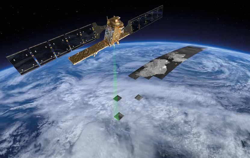
Reliable weather forecasts and
climate data thanks to satellites
Alex Rubli When TIROS 1 produced the first weather Satellites help us to understand
MeteoSwiss satellite images in 1960, the excitement must climate change
have been tremendous – meteorologists
had been developing theories about weather Satellites also make an important contribution to
fronts for half a century, and now, for climate observation. For the past 40 years they
the first time, they could actually see the have been taking regular measurements that help
bands of clouds and low-pressure vortices us to understand climate change better. Satellites
corroborating their theories. Today it is observe a number of different climate-relevant var-
impossible to imagine modern meteorology iables, accurately measuring the composition of the
and climate research without satellites. atmosphere, cloud structure, snow cover, glacier
extent, soil moisture, or sea level.
Switzerland has been using weather satellites sys-
tematically since 1977, when the European Space Satellite data are part of the Global Climate Obser-
Agency (ESA) sent its Meteosat 1 satellite into vation System (GCOS). Swiss institutions participate
orbit. Switzerland was one of the founding mem- in a number of international initiatives working to
bers of the European Organisation for the Ex- create comprehensive data sets from satellite data.
ploitation of Meteorological Satellites (EUMETSAT), For example, MeteoSwiss determines long-term
an interstate body established in 1986. Since solar radiation in a time series for the EUMETSAT
then, EUMETSAT has worked together with ESA climate observation initiative. The Swiss Federal
to ensure the smooth operation of the European Laboratories for Materials Science and Technology
weather satellites. Switzerland is also the deposi- (EMPA), the Federal Institute of Technology in
tary state for the EUMETSAT Convention. Zurich (ETH Zurich), and the University of Zurich
have been mandated by ESA’s Climate Change
Initiative to analyse data on greenhouse gas emis-
Satellites make our lives safer sions, clouds, and glaciers.
Nowadays, weather stations receive satellite images Satellite data also make other services possible that
every 15 minutes. These provide meteorologists directly benefit everyone, such as Switzerland’s
with an accurate overview of the weather situation interactive solar atlas implemented by MeteoSwiss,
and are an indispensable tool for making weather swisstopo, the Swiss Federal Office of Energy (SFOE)
forecasts and issuing weather alerts in particular. and Meteotest. The website www.sonnendach.ch
Satellite images make it possible to determine the is for all those interested in finding out if the roof
exact position of weather fronts. The data provide of their house can be used to generate solar energy
information on cloud structure, and meteorologists and how much heat and electricity can be pro-
can predict the potential for thunderstorms based duced too.
on this. Thanks to satellite data, meteorologists can
measure the temperature of clouds and the cloud
top, which can be used, for example, to warn pilots
if their aircraft is in danger of icing. Is there more
fog on the way? Or is it clearing up? Is the cloud
cover starting to dissipate? Will a clear winter sky
make the roads slippery? Meteorologists also use
satellite data to answer questions like these.
Weather satellites are becoming increasingly ef-
ficient. Numerical weather models are also being
further developed, which are fundamental today for
forecasting the weather. These models are fed with
millions of pieces of satellite data every day, which
means that the weather satellites also have their role
to play in ensuring that forecasts are even more ac-
curate and reliable – not only in the short term, but
for several days or even weeks in advance.
10MSG satellite image of weather systems in the northern hemisphere © EUMETSAT
Economic and social benefits
Satellite data make weather forecasts significantly more reliable than those
based ‘only’ on conventional observation. The EUMETSAT Polar Systems –
Second Generation (EPS-SG) satellites alone will generate savings of up to Euro
63 billion in Europe. The satellites were developed jointly by ESA and EUMET-
SAT. They are expected to deliver weather data from a polar orbit between
2021 and 2042.
This data will enable meteorologists to issue bad weather alerts earlier, so that
people and farmers can take precautions to reduce the potential damage to
their homes and crops, prevent crop losses, and even save lives. The economy
also benefits from more reliable weather forecasts. The aviation sector, for ex-
ample, has managed to make significant savings, thanks to weather forecasts,
such as by reducing flight delays and fuel consumption.
Excerpt from the solar atlas
(source: http://www.bfe-gis.admin.ch/sonnendach)
© SFOE, swisstopo, MeteoSwiss
11Safer landing thanks to the EGNOS
satellite navigation system
skyguide Satellite navigation is already having an How does EGNOS work?
impact on flight procedures and this will
increase in the coming years. The potential EGNOS consists of three geostationary satellites,
of new navigation technologies such as the which are ‘fixed’ at a point above the equator and
European Geostationary Navigation Overlay always emit signals in the same region, as well as
Service (EGNOS) lies primarily in their more a network of ground stations. The system continu-
accurate positioning. This enables safer ously verifies GPS signals and immediately transfers
landings of aircraft and helicopters as well its corrections to EGNOS receivers. Thus EGNOS
as more efficient air traffic management. increases the accuracy of the GPS signal so that air-
Pollutant and noise emissions are reduced, craft and helicopters can be navigated accurately
as are fuel consumption and airport opera- even in narrow valleys and when landing.
tors’ costs.
EGNOS is a joint project of the European Space
The European EGNOS satellite navigation system Agency (ESA), the European Union (EU) and the
complements the United States’ Global Position- European Organisation for the Safety of Air Navi-
ing System (GPS). It improves the accuracy and gation (EUROCONTROL), which developed it as the
reliability of navigation signals. Aircraft and heli- European Tripartite Group (ETP). It is Europe’s first
copters no longer have to rely on the instrument venture into satellite navigation and a precursor
landing system, especially when making a runway to the European satellite navigation system, Gali-
approach in poor visibility. Thanks to the high-per- leo, which it will complement in the future. Galileo
formance satellite system and appropriate on- should be fully operational by 2020 and its 30 sat-
board equipment, pilots making a landing can fol- ellites will cover the globe. European Satellite Ser-
low a three-dimensional flight path from the start vices Provider (ESSP), a company based in Toulouse,
of the descent until touching down on the runway. operates and markets EGNOS on behalf of the EU.
In Switzerland a national platform has coordinated
Phased introduction flight procedure projects since 2008 and provides
a framework for their implementation. In addition
EGNOS is being gradually introduced at all airports to skyguide, the Federal Office of Civil Aviation
in Switzerland and at Swiss Air Rescue (Rega) heli- (FOCA), the Air Force, the international airports of
copter bases. Each new implementation procedure Zurich and Geneva, regional airports, Rega and the
is tailored to the needs of individual airports and airlines Swiss and easyJet are represented on this
airspace users. Operators are not only able to in- platform.
crease safety and capacity but also to reduce the
costs of technical infrastructure needed on the
ground for landing approaches.
“The EGNOS system is a huge step forward for us,” says Rega
chief pilot Heinz Leibundgut. “Thanks to EGNOS we can
navigate much better in difficult terrain, even in poor visibility
and during night missions. This is an enormous advantage
particularly in Switzerland. EGNOS means Rega can frequently
also undertake missions in difficult weather conditions. It
increases safety for pilots and passengers while speeding up
rescue operations.”
Thanks to EGNOS, Rega was able to perform the first heli-
copter precision approach in Europe. © Rega
121
2 2 2 2 2
2
3 4 3
Procedure based on GPS and EGNOS
1 European Geostationary Navigation Overlay Service (EGNOS)
2 Global Positioning System (GPS)
3 Reference stations
4 Master control station
© skyguide
The role of skyguide
Skyguide has been a member of the EGNOS Op-
erators and Infrastructure Group (EOIG) since the
start. EOIG provided ESA and its member states
with the necessary expertise in specific areas and
advised them on technical and operational flight
safety issues, enabling them to develop a satellite
system that meets the highest safety and efficiency
demands for flight operations. Skyguide is a share-
holder in ESSP along with the national flight safety
agencies of Germany, France, the United Kingdom,
Italy, Portugal and Spain.
Skyguide is the Swiss air traffic control authority. It is respon-
sible for the safe, smooth and cost-effective management of
civil and military air traffic in Switzerland and in the adjacent
airspace assigned to its control. In addition to overflights,
skyguide manages air traffic at the two major international
airports of Geneva and Zurich and at the 12 regional airports in
Switzerland.
13Satellite data and Swiss
know-how increase yields and
reduce risks for rice farmers
Michael Anthony Asia is the world’s rice bowl. Some 90 per of the data themselves as part of the RIICE project
sarmap SA cent of rice is grown in Asia, where it is (Remote Sensing-based Information and Insurance
a staple food eaten two to three times a for Crops in Emerging Economies). Since 2013, the
day. Unfortunately, droughts and flooding private sector, academia, and government agencies
damage harvests time and again, leaving have been working internationally in a public-pri-
rice bowls empty. Since 2015, satellites have vate partnership to use the remote-sensing satellite
been helping to provide early warning and imagery to forecast crop yields and make the infor-
to measure the extent of flooding. This mation available for insuring rice fields. The Swiss
information helps to improve food security Agency for Development and Cooperation (SDC)
while allowing farmers to receive compensa- and the Swiss remote-sensing company sarmap,
tion more quickly when crops fail. which is based in Ticino, are working on the RIICE
project together with IRRI, the German insurance
company Allianz, and the German Agency for In-
The RIICE project ternational Cooperation (GIZ). The aim is to map all
the rice-growing areas in Asia, forecast yields, and
The satellites capture data on rice-growing areas record the actual harvests.
in Asia, making it possible to forecast yields with
a precision of up to 90%. The processed satellite
data are fed into a rice growth simulation model Satellites improve food security and
developed by the International Rice Research Insti- help get aid to where it is needed fast
tute (IRRI), which is based in the Philippines. The
Sentinel-1A satellite maps the earth’s rice fields The satellite data directly benefits food security
every 12 days. The images make it possible to mon- and contributes to the fight against poverty. RIICE
itor crop growth and assess damage from natural is not only able to reduce or even prevent crop
disasters. losses thanks to this data. It can also help in spe-
cific ways to get aid to where it is needed more
Switzerland provides the technical know-how. The quickly in the wake of natural disasters. And it en-
satellite data are processed in Switzerland before sures that rice farmers’ claims for compensation are
government-associated research institutes in part- paid more swiftly. The radar sensors of the Sentinel
ner countries gradually take over the processing satellites can instantly detect damage to crops at
any moment, in all weather conditions, through
any amount of cloud cover.
Sentinel-1A
The 2.3-tonne satellite Sentinal-1A has a radar eye that can see through all When, for example, a typhoon devastated large
weather conditions and any amount of cloud cover to transmit images of parts of the southern Indian state of Tamil Nadu in
the earth’s surface at 5x5 m spatial resolution. It orbits the earth at 693 km November 2015, the data was invaluable in allow-
altitude at a speed of approximately seven km per second (about 25,000 km ing the authorities to get an idea of the scale of the
per hour). Sentinal-1A has been sending images to earth since October 2014. disaster and send relief to the affected area. Such
It was developed by ESA and is being operated in the framework of the EU’s a quick response was only possible thanks to the
Copernicus programme. satellite data.
Key RIICE statistics Satellite technology is not only useful for emer-
90% of the world’s rice is harvested and consumed in Asia. gency relief. It also provides crucial information for
30% of the total crop yield (in USD) in Asia comes from rice. agricultural insurance providers, making it possible
In Asia rice is grown on 18 million hectares. RIICE has already mapped almost to quickly and efficiently calculate losses from crop
half of this area. failure. This benefits the farmers, who receive their
RIICE is working with five governments in Asia to use the rice information to insurance money early enough to reinvest in new
provide insurance coverage for crop failures. seeds without having to take out a new loan and
RIICE is the only initiative which provides regular information on plant incur new debts.
growth and harvest forecasts in rice fields across Asia.
14The Sentinel-1A satellite © ESA
Copernicus: Global observation for the
environment and security
17-SEP-2015_26-SEP2015 Copernicus is the EU’s Earth observation pro-
27-SEP-2015_06-OCT-2015
gramme. Based on ground-, air- and satellite-
07-OCT-2015_16-OCT-2015
17-OCT-2015_26-OCT-2015 based observations, it provides geoinformation
27-OCT-2015_05-NOV-2015 services for environmental monitoring and
06-NOV-2015_15-NOV-2015
security. The observations from space are mainly
16-NOV-2015_25-NOV-2015
26-NOV-2015_05-DEC-2015 carried out by the Sentinel satellites specifically
06-DEC-2015_15-DEC-2015 developed for Copernicus. The main users of such
The image shows the start of the rice information services are European, national
season in Cambodia in November 2015 and and regional authorities as well as business and
shows in conjunction with the table on the research. The Copernicus services support a wide
right when and where the rice fields were
range of applications in land use, the marine
planted. © Copernicus data (2015)
Background map ©OpenStreetMap contributors environment, the atmosphere, disaster and crisis
management, climate change and security.
The image, composed of various data sets The Copernicus initiative was launched jointly
captured over Cambodia during the 2015 by the EU and ESA in 1998. Switzerland has since
harvest season, displays surface differences been involved in developing satellites and infor-
in varying colours: the dark blue areas are
mation services within the framework of various
water, settlements and infrastructure are
EU and ESA programmes. The EU launched the
white, different shades of green represent
forests of various types and thickness, operational programme in 2014, with major
and the light blue to purple areas show parts of the implementation being delegated to
farmland at different stages of cultivation. existing organisations in which Switzerland is
© Copernicus data (2015)
Background map ©OpenStreetMap contributors
involved such as ESA, EUMETSAT, the European
Environment Agency (EEA), and the European
Border and Coast Guard Agency (FRONTEX).
15Detecting natural hazards early,
thanks to satellite radars
Urs Wegmüller Satellites have been observing the glaciers, Reliable data to the millimetre
Gamma Remote slopes, and cliffs for more than 20 years.
Sensing AG But they have also been viewing Alpine The radar waves allow us to determine the topog-
infrastructure (railways, dams, buildings) raphy and movements in the terrain reliably. The
using satellite radar interferometry. These satellite radar system records data on the area
methods allow us to detect natural hazards under observation at regular intervals – under al-
early on, to keep up to date with the risk most all weather conditions and in high quality.
potential, and to draw up a list of imminent This means that even minimal changes of a few
dangers and update it regularly. millimetres or centimetres can be established. Be-
tween 2002 and 2012, Switzerland used the Euro-
Radar interferometry opens up a world of possibili- pean Space Agency’s (ESA) environmental satellite
ties for us to create hazard maps and moving maps ENVISAT. The Sentinel-1A satellite became opera-
of natural events such as volcanic eruptions, earth- tional in 2014.
quakes, landslides, unstable cliffs, changes in the
permafrost, and ice avalanches. It can also chart With minimal effort, previous movements in the
movements in the terrain caused by humans, for terrain can be reconstructed by comparing several
example mining for gas and petroleum extraction, radar pictures taken at different times. The new
in abstraction of ground water, or construction of generation of satellites are even able to capture
buildings. movements in real time. Using data that have been
collected over years, we can create an inventory
of possible hazards; the risk potential can then
be updated with current data. Ground-based in-
terferometry sensors are also used for up-to-date
-5mm/year 0 +5mm/year
local surveillance. They can perform measurements
every minute, which also means they can be used
for early warning systems.
Working in Chli Windgällen
We ran a pilot experiment using satellite-based dis-
placement measurements in the Reuss valley be-
tween Sisikon and Wassen, particularly in the area
of Chli Windgällen. Thanks to comprehensive data
from a 20-year series of measurements taken by
both the ERS and ENVISAT satellites we could gen-
erate retrospective readings and interpret them in
geological terms. This allowed us to calculate move-
ments in the terrain with a measurement accuracy
of 1 mm/year and spatial resolution of about 20
meters for linear motion without having fixed meas-
uring points beforehand. The mandate for this was
issued by the Swiss Federal Railways, which uses the
Average displacement results for their monitoring set-up on the main ar-
rate for the Reuss valley tery linking northern and southern Europe.
between 2003 and 2010 –
calculated on the basis of
These methods are also used in the Alpine region
ENVISAT data. Signifi-
cant movements were in Switzerland for mapping landslides and cliff in-
observed particularly in stability. We assessed data from various radar sat-
the Windgällen region ellites extensively in a mandate from the Federal
(blue circle), above Silenen. Office for the Environment, which then used the
ENVISAT data copyright ESA, SAR/
InSAR Processing Gamma Remote
information to create hazard maps with various
Sensing AG danger levels.
16ESA’s environmental satellite ENVISAT.
Operational between 2002 and 2012 © ESA
Satellite radar interferometry
This is a method whereby satellites send radar waves to the Earth’s surface
where they are reflected. This allows us to make very accurate distance
measurements between the satellite and the Earth’s surface. If a slope is in
movement, the distance between the satellite and the Earth’s surface will
change from one measurement period to the next. Interferometric methods
of analysis calculate these differences in distance with high precision and
create a map based on this.
These methods give us new possibilities to monitor uninhabited areas where
there are no other measurement networks. Thus radar interferometry is also
particularly well-suited for monitoring slopes that were previously stabilised
by permafrost, but which are now melting due to climate change and are
starting to move.
17Space is part of daily life and an
economic driver for Swiss industry
Peter Guggenbach Swiss companies are playing a leading their way into other areas. For example, Earth ob-
President of the Swiss role in space. Very few space missions can servation satellites help to understand the complex
Space Industries Group accomplish their goals without cutting- interrelations of ecosystems at the global level,
(SSIG) edge technology from Switzerland. This monitor the environment, and use resources more
benefits Switzerland not only as a centre efficiently (see page 14). Accurate weather fore-
Raoul Keller of research and education but also as an casts are inconceivable without satellite data (see
Director of the Swiss industrial centre. The space sector creates page 10).
Space Industries Group sustainable high-quality jobs in Switzerland,
(SSIG) ensures transfer of know-how, and promotes The space sector is also economically profitable.
development and applications in other Switzerland contributed 3% towards the costs of
industrial sectors. the ESA/EUMETSAT weather-satellite programmes,
and thereby obtained the right to use all the func-
Switzerland’s space sector is a strategically impor- tions of the satellites (which were partly built in
tant growth industry. It obtains high-value orders Switzerland). The overall economic benefit over
and develops structures such as payload fairings the next 20 years is expected to be 15 to 60 times
for launchers, satellite structures, precision mech- the EUR 3 billion that will have been invested in
anisms, on-board electronics, space transponders, the satellite programme. Among ways Switzerland
engine components, new materials, payload fairing, uses satellite data is to protect the nation’s popula-
measurement technology, and scientific and medical tion and infrastructure from landslides and weather
instruments. These developments often lead to prof- hazards (see page 16).
itable applications for everyday use here on earth.
Activities in space also shape our communication, The European Commission’s Copernicus pro-
infrastructure, and mobility on earth. gramme makes satellite data available for envi-
ronmental protection and civil security worldwide.
Switzerland not only produces key components for
The impact of the space satellites but also uses Copernicus data, for exam-
sector on everyday life ple, for climate change research (see page 15).
Space technology is part of our daily life, even if PulsEar, a heart-rate monitor developed by the
we are not aware of it: every time we watch TV, CSEM, the Swiss Center for Electronics and Micro-
make phone calls, write emails, or rely on our car’s technology, is another example. The PulsEar sensor
GPS system, we are using developments from the is integrated in an ordinary earphone and displays
PulsEar – the earphone space sector. In the last two years, more than 270 users´ heart rates in real time on the iPhone. The
that measures your heart applications developed within the framework of PulsEar technology was originally developed for
rate © CSEM European Space Agency (ESA) programmes found ESA in order to monitor human behaviour during
long-term missions in space.
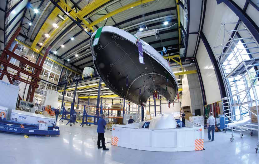
18Structure of the european Intermediate eXperimental Vehicle IXV, built by
RUAG Space, handled by APCO Technologies’ Mechanical Ground Support
Equipment © ESA
Jobs for highly specialised professionals
ESA space programmes create jobs in Switzerland
for highly qualified professionals and at the same
time promote exchange of knowledge and coop-
eration between research and industry. The space
industry employs people who have graduated from
higher-education institutions as well as specialists
from a wide range of fields. The industry brings in
expertise in electronics, optics, precision engineer-
ing, aerodynamics, thermodynamics, computer sci-
ence, material sciences, and 3D printing processes.
The 21 companies of the Swiss Space Industries
Group (SSIG) employ over 900 professionals whose
work is directly related to space technology. The
companies’ annual turnover is CHF 270 million. In
addition, several thousand people in Switzerland Swiss on-board electronics: Mass memory and formatting unit for ESA’s
– particularly professionals working in companies EarthCARE mission, built by Syderal SA © Syderal
in the machine, electrical engineering, and metals
industries which supply key components to the
space industry – work indirectly to serve the space
industry.
19No Ariane rocket launch
without Swiss hi-tech
Hendrik Thielemann Switzerland is on board every European Partner from day one
RUAG carrier rocket flight – often with a payload
fairing. This nose cone protects the space- Switzerland has partnered the Ariane programme
craft and makes sure that the satellites pass from the outset. A RUAG Space payload fairing was
through the Earth’s atmosphere safely. It even in use during the first launch on 24 December
dampens the sound of the rocket launch, 1979. In addition to Ariane, since 2012 Europe has
protects the spacecraft from overheating, had a second carrier rocket – Vega – which is also
and keeps dirt away. equipped with a Swiss payload fairing. While the
almost 60-metre-high ‘heavy transporter’ Ariane 5
It only takes around three and a half minutes for can transport two large telecommunications satel-
an Ariane rocket to leave the Earth’s atmosphere – lites weighing a total of 10 tonnes and more into
about 120 km upward. But it has to endure quite a geostationary orbit, the roughly 30-metre-high
a lot in those few minutes. For example, the en- Vega brings small to medium-sized payloads into a
gine noise is so loud that a person in the immediate low Earth orbit. This makes Vega particularly well
vicinity would not survive. The high airspeed caus- suited to transporting satellites for Earth observa-
es enormous aerodynamic loading, and the outer tion, meteorology, and research.
shell of the spacecraft heats up to around 700°C.
All of this would be far too much for the sensitive RUAG Space engineers can look back over a history
satellites to endure – journeying into space on the of over 250 successfully completed flights. This kind
tip of the rocket’s nose – were it not for a special of reliability is likewise in demand in the United
kind of protection made in Switzerland – the pay- States, the world’s leading space-faring nation,
load fairing, a 17-metre-long aerodynamic hood where Swiss technology is also being employed.
which provides reliable protection for satellites en- The currently most important US carrier rocket for
capsulated underneath at the upper stage of the transporting large satellites into space, Atlas V, has
rocket. been flying since 2003 with a Swiss-made carbon
fibre hood. RUAG Space is currently developing the
The Swiss aerospace company RUAG Space is a payload fairings for the next generation of Ariane
global market leader when it comes to safely man- 6 rockets in Europe and the Vulcan rocket in the
aging the first three minutes after a rocket launch. USA.
It provides the payload fairings for the European
carrier rockets Ariane and Vega, which contributes
significantly to the rocket programme securing an
autonomous European access to space. The Ariane
rocket is also commercially very successful, thanks
to Swiss hi-tech, bringing around one half of the
biggest commercial telecommunications satellites
from around the world into space.
20The payload fairing for a Vega rocket is packed for
transportation at RUAG Space in Zurich © RUAG
The Ariane Programme
The programme to develop and build European launch vehicles began in 1973.
The main aim was to enable Europe to independently access space, thereby
reducing its dependence on other space-faring nations. The European Space
Agency (ESA) has since developed five generations of Ariane rockets – work on
the sixth generation began in 2014 – and provided funding for construction of
a european launch pad in Kourou, French Guiana.
Their constantly improving performance and high reliability has meant that
most commercial satellites are launched today by Ariane rockets. The Ariane
programme also played an important part in supplying the International
Space Station (ISS). The rockets launched five automated transport vehicles
which took supplies and experiments up to the ISS between 2008 and 2014
(see page 30).
Launch of an Ariane 5 rocket on 18 June 2016 at the
European spaceport in French Guiana with two satellites
on board. The rocket nose is protected by a RUAG payload
fairing © ESA
21Swiss atomic clocks improve the accuracy
of our satellite navigation systems
Pascal Rochat Satellite-based navigation systems are so Atomic clocks ‘made in Switzerland’
Spectratime much part of our lives that it is hard to
imagine everyday activities like hiking and Atomic clocks bear little resemblance to our idea of
driving without them. Activities such as an ordinary clock with a dial and hands. They need
surveying, farming, and the management of an oscillator like an ordinary clock, but – instead of
land, sea and air traffic also depend on these a pendulum – they use oscillations in the energy
systems. And it goes without saying that we level of an atom. Spectratime, a company based in
expect the data they provide to be accurate Neuchâtel, designed two different clock types for
to within a few metres or even centimetres. the European satellite navigations system Galileo.
The clocks are based on rubidium and hydrogen
To produce such exact data, satellite navigation sys- atoms. The latter type is the most precise clock in
tems use precisely synchronised, stable and highly space. In three million years they only lose or gain a
accurate atomic clocks. The navigation satellite sig- single second. Every satellite carries a backup clock
nals are used along with a ‘time stamp’ from the of each type. The satellites transmit the current
atomic clocks to determine accurate positioning. time and their position back to Earth. A receiver
Since the signals sent by the satellites are transmit- device can then calculate its exact position based
ted at the speed of light (300,000 km/s), even the on how long it took for the signals to arrive. Global
slightest of errors affects the accuracy of the posi- positioning relies on at least four satellites to trans-
tioning measurement. If an atomic clock in a satel- mit signals which are synchronised to a billionth of
lite is ‘off’ by as little as a nanosecond (a billionth a second.
of a second), it makes a difference of 30 cm. The
clocks must also withstand strong vibrations during Atomic clocks in space are also used for telecom-
the launch and when the satellites are released munications, radio astronomy and measuring
from the launcher’s upper stage. As they travel into physical effects at the limit of what can be meas-
space and orbit the Earth, atomic clocks are also ured. Moreover, many everyday applications on
subjected to extreme temperature changes. Once Earth also rely on the highly accurate time signals
in space, no maintenance can be carried out on from space that atomic clocks transmit everywhere
them. on the planet. To begin with, they are used to es-
tablish Coordinated Universal Time (UTC). Commu-
nication networks cannot be synchronised with-
Atomic clock by Neuchâtel-
based company Spectratime, out such reference signals, or power grids might
interior casing by Argotec, collapse at peak times or mobile phone and inter-
Aargau. © Spectratime net communications would become unreliable or
slow down. Paying by credit cards in shops and
electronic trading of securities are among many
other activities which would not be possible with-
out atomic clocks and satellite signals from space.
22The complete Galileo constellation with eight satellites in
each of three orbital planes (plus two reserve satellites in
each orbital plane). © ESA
The European satellite navigation systems Galileo and EGNOS
Galileo will end European users’ dependence on the USA’ Global Positioning
System (GPS). Upon completion (scheduled for 2020), Galileo will consist of a
constellation of 24 satellites on three orbital planes. Each of the orbital planes
will also have two reserve satellites. This constellation will ensure that at
any given point in time at least four satellites are ‘visible’ from anywhere on
Earth, allowing positioning accuracy to within a metre.
The European Geostationary Navigation Overlay Service (EGNOS), a regional
navigation system, has already been in operation since March 2011. It
improves the accuracy and reliability of GPS signals and can be received over
Europe and North Africa. With its development at the European Space Agency
(ESA) complete, EGNOS was handed over to the EU in 2009, and the EU now
manages the service’s operation. EGNOS signals are particularly useful in
guiding aircraft during landing approaches in poor weather conditions (see
page 12).
Switzerland is involved in the development and operation of both systems.
Switzerland and the EU signed a cooperation agreement in December 2013. The
agreement has been applied provisionally since 1 January 2014. Switzerland rati-
fied the agreement in 2015. Ratification is still under way within the EU.
23The European Space Agency (ESA)
From the start of the space age, Europe has Alongside its own programmes, as decided and
been active in space. Whilst it was initially funded by Member States, ESA also manages
mainly a matter of scientific curiosity, today, activities for third parties, for example the develop-
the motivation for Europe’s diverse space ment of the next generation of weather satellites
activities is much broader: space brings for EUMETSAT or the construction of the satellite
at the forefront technology and services constellations for the EU Galileo programme (Navi-
which are essential for a modern society, it gation) and Copernicus (monitoring of the environ-
expands our knowledge of the universe and ment). Further, ESA has entered into Public Private
of our own planet, it provides up-to-date Partnerships with numerous commercial providers
information enabling us to respond to global in the satellite communications sector. The Agency
challenges, it creates highly skilled jobs and is also responsible for the development of the
strengthens the European industry’s com- Ariane and Vega launchers, which are themselves
petitiveness and capacity for innovation. commercially exploited by Arianespace.
The European States recognised early on that the ESA’s annual budget is EUR 5.3 billion (2016), the
breakthrough in space would only be possible most significant part of which flows back to the
though cooperation. European States had been Member States in the form of research and devel-
working together on the development of launchers opment contracts. The competences and products
and on scientific satellites already since the early developed by the participating institutes and com-
1960s. With the foundation of the European Space panies bear witness to the economic benefit; the
Agency ESA in 1975, these activities were brought return being many times higher than the contribu-
together under one organisation, with Switzerland tion of the Member States. ESA, with its headquar-
being among the 10 founding States. ters in Paris, employs around 2,200 people who
come from all Member States and are stationed at
Today, ESA has 22 Members States with Canada the different technical centers in Europe.
as an associated Member participating in vari-
ous programmes, and Slovenia having signed an
association agreement in 2016. ESA is an independ-
ent, intergovernmental organization. It maintains
a close relationship with the European Union; the
two are linked through a framework agreement.
Today, ESA’s activities cover practically all space do-
mains, namely
»» Launchers
»» Space Science
»» Human and robotic exploration
»» Earth Observation
»» Navigation
»» Technology, Telecommunications
and Integrated Applications
»» Space Situational Awareness
24ESA Member States (dark
grey), associated and
cooperating States (light
grey) © ESA
ESA Director General
Johann-Dietrich Wörner
© ESA
“Space is important to a modern society. Space contributes to industrial
competitiveness and, in so doing, generates jobs and growth. Space is about
cooperation as a means of achieving success. Space inspires people to pursue
education and embark on fascinating, fulfilling careers.
ESA is the space agency for Europe, and it is ready to take specific actions for
its Member States. We see the diversity of our Member States as an asset, with
each bringing its own particular competences. For example, Switzerland not
only provides key technologies and products to European space programmes –
it has also made essential contributions to the coordination of space activities
in Europe.
Switzerland hosted ESA’s Ministerial Council in Lucerne on 1 and 2 December
2016, an opportunity to show the public in our Member States that space is
relevant to every citizen, that it contributes to the growth of our economies
and to our overall competitiveness while enriching and improving our daily
lives through innovation, information, interaction and inspiration.”
25ESA chairmanship:
Switzerland in charge for Europe
Balz Abplanalp Switzerland’s access to outer space has been ESA will be able to retain its status as an intergov-
Diplomatic adviser for ensured by the European Space Agency ernmental organisation in the future, thanks to po-
the ESA co-chairman (ESA) for over 40 years. It joined Luxembourg litical resolutions on developing ESA adopted at the
ship, FDFA recently in co-chairing the organisation’s ministerial councils in Naples and Luxembourg. This
ministerial council for the first time from strengthens ESA as an institution and boosts its po-
2012 to 2016. Both countries agreed to a sim- sition as an independent and essential cooperation
ple division of tasks from the start, with partner for the EU. This is also in Switzerland’s in-
EU-member Luxembourg being respon- terest.
sible for relations between ESA and EU,
while Switzerland took charge of all ESA Switzerland’s co-chairmanship of ESA has thus
programmes. Luxembourg’s Deputy Prime achieved its political objectives and helped
Minister Etienne Schneider (from the end of strengthen space-travel stakeholder networks in
2013) co-chaired with Mauro Dell’Ambrogio, research and industry. ESA ministerial council in
the Swiss State Secretary for Education, Lucerne from 1 to 2 December 2016 has marked
Research, and Innovation (SERI). the close of the co-chairmanship.
ESA’s ministerial council is where the 22 member
states set out the organisation’s strategic, pro-
grammatic, and financial policies for the upcoming
period. Together with the ESA director general,
the co-chairmanship was tasked with preparing a
set of space programmes that met the needs and
wishes of all member states. If successful, the min-
isters will grant sufficient funding for the long-term
programmes that need new financial resources
every few years. An example is the 12-year ESA
Rosetta mission, which succeeded in placing a
robotic lander on a comet for the first time ever on
12 November 2014.
Despite the recent economic crisis, ministers at
the 2012 council in Naples and the 2014 council
in Luxembourg committed funds of over EUR 15
billion for ESA’s programmes. This large financial
commitment reflects the ministers’ conviction that
investing in innovations for research and space in-
frastructure provides a major boost to economic
growth in Europe. Its contribution to Europe’s com-
petitiveness in this field also reflects favourably on
Switzerland’s co-chairmanship, which has helped
to bring about key decisions behind the scenes. For
example, it led the lengthy negotiations on devel-
oping the new carrier rocket Ariane 6 and success-
fully negotiated between ESA member states and
the industry sector. Developing Ariane 6 will create
a number of high-skilled jobs in the next few years.
They include jobs in Switzerland, which is actively
involved in the programme. This will also help
boost the Swiss location as a centre for industry
and research.
26You can also read