Strategy Towards an Architecture
for Climate Monitoring from Space
←
→
Page content transcription
If your browser does not render page correctly, please read the page content below
Strategy Towards an Architecture for Climate Monitoring from Space
Contributing Authors:

Mark Dowell
European Commission, Joint Research Centre

Pascal Lecomte
European Space Agency

Robert Husband
European Organisation for the Exploitation of Meteorological Satellites

Jörg Schulz
European Organisation for the Exploitation of Meteorological Satellites

Tillmann Mohr
WMO, Special Advisor to the Secretary General on Satellite Matters

Yoshihiko Tahara
Japan Meteorological Agency

Richard Eckman
National Aeronautical and Space Agency

Eric Lindstrom
National Aeronautical and Space Agency

Charles Wooldridge
National Oceanic and Atmospheric Administration

Suzanne Hilding
National Oceanic and Atmospheric Administration

John Bates
National Oceanic and Atmospheric Administration

Barbara Ryan
World Meteorological Organization

Jerome LaFeuille
World Meteorological Organization

Stephan Bojinski
World Meteorological Organization

Full Citation for this publication:

M. Dowell, P. Lecomte, R. Husband, J. Schulz, T. Mohr, Y. Tahara, R. Eckman, E. Lindstrom, C. Wooldridge, S. Hilding,
J.Bates, B. Ryan, J. Lafeuille, and S. Bojinski, 2013: Strategy Towards an Architecture for Climate Monitoring from Space.
Pp. 39. This report is available from: www.ceos.org; www.wmo.int/sat; http://www.cgms-info.org/

Table of Contents
1. Executive Summary.................................................................................................................................................. 6
2. Introduction and Objectives................................................................................................................................ 7
3. Climate Monitoring Principles, Requirements & Guidelines................................................................ 9
3.1 Specific Requirements for Climate Monitoring......................................................................................... 9
3.2 Sources of Requirements.................................................................................................................................11
3.3 Relevant Requirements for Climate Change Monitoring.....................................................................12
3.4 Requirements Related to Climate Modelling...........................................................................................13
3.5 Requirements for Data Archiving, Processing, Documentation, and Distribution.....................14
4. Existing Capabilities and Processes................................................................................................................16
4.1 Fifty Years of Environmental Satellite Missions........................................................................................16
4.2 Current and Planned Satellite Missions for Climate...............................................................................16
4.3 Gap Analyses of Satellite Missions Compared with GCOS Requirements for ECVs....................18
4.4 Satellite Instrument Calibration Activities.................................................................................................20
4.5 From Satellite Data to Validated Climate Data Records........................................................................22
4.6 Emerging Coordination....................................................................................................................................25
5. Beyond Research to Operations.......................................................................................................................27
6. Climate Architecture Definition........................................................................................................................29
6.1 What do we Mean by the Term “Architecture”?.......................................................................................29
6.2 Why do we Need an Architecture for Climate Monitoring?................................................................29
6.3 What could be an Appropriate Format/Structure for an Architecture?..........................................29
6.4 What Could be the Main Components of a Logical View?...................................................................30
6.5 What Could be the Main Components of a Physical View?.................................................................32
7. Mechanisms for Interaction................................................................................................................................33
7.1 What are the Needs for Mechanisms for Interaction?...........................................................................33
7.2 Longer-term Governance Considerations.................................................................................................33
7.3 Initial Integrator Activities...............................................................................................................................33
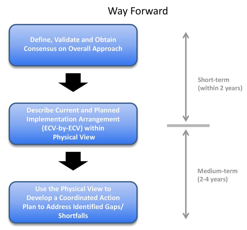
8. Roadmap for the Way Forward..........................................................................................................................34
9. Glossary .......................................................................................................................................................................36
10. References...................................................................................................................................................................366
1. Executive Summary • In general, current observing systems have not
been primarily designed with a climate perspec-
This report focuses on satellite observations for climate tive, therefore, inventories are needed to docu-
monitoring from space, and the need for an international ment the contributions of current and planned
architecture that ensures delivery of these observations observing systems for climate purposes.
over the time frames required for analysis of the Earth’s • Requirements for mission continuity and contin-
climate system. The report outlines a strategy for such an gency need improvement through international
architecture – a strategy that is intentionally high-level, collaboration of space agencies.
conceptual and inclusive, so that a broad consensus can • Sustained Climate Data Record (CDR) pro-
be reached, and all relevant entities can identify their po- grammes will provide an avenue to replace heri-
tential contributions. The strategy, however, is not suffi- tage algorithms and data sets with improved ver-
cient, in and of itself, and therefore also presents a logical sions once they are successfully demonstrated,
architecture that represents an initial step in the develop- validated and available.
ment of a physical architecture – an end-to-end system • There is an imperative need to ensure traceability
– capable of delivering the necessary observations for cli- along harmonised practices.
mate monitoring from space.
In terms of the way forward, some concrete actions in-
The report was written by a team of people comprised of clude, but are not limited to:
representatives from the Committee on Earth Observa-
tion Satellites (CEOS), the Coordination Group for Meteo- • Achieve a consensus on the general approach,
rological Satellites (CGMS) and the World Meteorological first engaging, in an ongoing manner, with the
Organization (WMO). The intended audiences include relevant coordination bodies and their subsid-
space agencies, their political and budget authorities, iary groups (including, but not restricted to,
their international coordinating mechanisms, and nation- CEOS, CGMS and WMO).
al and/or international programmes and organisations • Further involve the scientific community in re-
with climate-related mandates. viewing the proposed approach as a second step
in the consensus building process.
The architecture proposed herein, calls for a constellation • Verify that the proposed logical architecture ad-
of research and operational satellites, broad, open data- equately supports, in a top-down context, the
sharing policies and contingency planning. It includes depiction of the required information flows from
agreements that are essential for bringing the same con- the decision-making process back to the sensing
tinuity to long-term and sustained climate observations capacity/requirements,
that we have today for weather observations. The task of • Design a physical architecture that captures the
climate monitoring, however, has requirements that must current and planned implementation strategies,
extend beyond the capabilities of one-time research mis- on an Essential Climate Variable (ECV)-by-ECV
sions and operational satellite systems in existence today. basis.
This report, therefore, identifies an important activity • Define an optimum “macroscale” space system
for research and operational agencies to undertake: the configuration and its components (in the form
development of a joint framework for stewardship of cli- of sub-constellations for each ECV or groups of
mate information. Climate record processing requires a ECVs), as well as the respective ground systems
sustained expert understanding of both new and legacy from the combined perspective of the logical
climate sensors as well as a sustained web of support and physical architectures.
activities, including a significant effort on calibration • Develop the physical architecture as an iterative
and validation; research to reduce uncertainties, estab- process with continuous/periodic updates as
lish “community reference standards”; and collaborative new observational capabilities become available
product assessment and intercomparison. The sustained or existing ones mature so that gaps and short-
involvement of both research and operational agencies is falls can be addressed.
a prerequisite for success. • Verify the overall robustness of the architecture’s
structure for new applications, and for continued
Significant aspects evidenced in the report include, but maintenance, with a clear view of the end-to-
are not limited to: end information flows as the architecture ma-
tures and the development of climate services
becomes further defined.Strategy Towards an Architecture for Climate Monitoring from Space 7
The report clearly identifies an imperative need for fur- tions, can be used in joint analyses with satellite data, and
ther and wider coordination among all stakeholders, both in specific cases (e.g. optical measurements of land and
technical and policy-related, in order to optimise efforts ocean surfaces) provide a means of vicariously calibrating
to measure and document traceability and to secure the the space-based observations. Therefore, the combina-
necessary resources for implementation. From a techni- tion of satellite and ground-based observations is essen-
cal perspective, there is a need to seek greater involve- tial. While recognising the importance of integrated ob-
ment from the scientific community, relevant technical serving systems, the initial focus of this architecture effort
groups and utilise other available mechanisms for further lies with the space-based component.
development of the physical architecture. From a policy
perspective, the proposed logical architecture must be Many observations have been derived from satellites
verified to ensure that the information flows (from re- and sensors which were either not designed for climate
quirements to decision-making) are capable of meeting purposes, or were not intended to operate over the long
both policy and user-service needs. time frames needed for climate assessments. Contin-
gency agreements between space agencies have been
While much has been done over the last decade and lon- instituted for weather observations to ensure continuous
ger to better address the monitoring of Earth’s climate observations for global numerical weather prediction, but
from space, more remains to be done. The strategy pre- not specifically for climate purposes. While much prog-
sented in this report not only leverages the historic work ress has been made recently, data-sharing policies and
and accomplishments of operational and research and practices are still not as robust for climate data, as they
development space agencies (and their partners), but are for weather data. And, reinforcing the need for this
extends that work to ensure that the requirements for strategy, there currently exists no international, compre-
observing the Earth’s climate system on a routine and sus- hensive task definition and planning, or even a design for
tained basis can be met. undertaking this task, for climate monitoring from space.
An architecture calling for a constellation of research and
2. Introduction and Objectives operational satellites, a broad, open data-sharing policy,
and contingency planning is essential in order to bring
The role that satellites have played in observing the vari- the same continuity to long-term and sustained climate
ability and change of the Earth system has increased observations that we have for weather. Ultimately, such
substantially over the last few decades. Significant prog- an architecture should result in a combination of existing
ress has been made in observing the Earth globally, with constellations (both virtual and real) and dedicated satel-
higher temporal and spatial resolution, which before the lite missions for climate variables that are not currently ad-
advent of satellites was all but impossible. With satellite dressed, or poorly addressed through existing monitoring
observations of the Earth, we have been able to construct capabilities. It must include end-to-end climate informa-
global views of many variables across the atmospheric, tion stewardship, consisting of data collection, data qual-
oceanic and terrestrial domains, including ozone, cloud ity, archiving, processing and re-processing, discovery and
cover, precipitation, aerosol optical depth, sea surface access required for climate data record production. The
topography, changes in polar ice masses, and changes discussions being held today for climate monitoring are
to the land surface. Indeed, with some satellite observa- remarkably similar to the early discussions for a globally
tions now spanning more than 40 years, the value of this coordinated “architecture” for weather monitoring, which
information for climate monitoring purposes is becom- have led to the successful end-to-end meteorological sys-
ing increasingly evident. Yet, more remains to be done. tem that we have today (see Section 4 for more detail).
Although the subject of this report focuses on satellite
observations for climate monitoring, the role that in situ There are international, as well as national, policy man-
observations play must not be overlooked. Existing in situ dates or structures regarding climate and climate change.
networks1 provide observations of some parameters that In 1988, the Intergovernmental Panel on Climate Change
are difficult and/or impossible to measure from space. (IPCC) was established by the United Nations Environment
These can serve validation purposes for satellite observa- Programme (UNEP) and the World Meteorological Organi-
zation (WMO) to review and provide recommendations to
1
Examples of key surface-based networks contributing to cli- governments regarding the state of knowledge of the sci-
mate observations include, but are not limited to, the GCOS Up- ence of climate change, the risks associated with human-
per Air Network (GUAN) and GCOS Reference Upper Air Network induced climate change, the social and economic impacts
(GRUAN), the Argo Ocean Buoy Network, the AErosol RObotic of climate change and possible response strategies. In
NETwork (AERONET), and WMO’s Global Atmosphere Watch
(GAW) and Regional Basic Climatological Network (RBCN). 1992 the United Nations Framework Convention on Cli-8
mate Change (UNFCCC) – an international environmental There are three key audiences for this report. First, the co-
treaty – was established to agree on actions for reducing ordinating groups who have undertaken the writing ef-
global warming, including adoption by a number of coun- fort, and their members. In the case of CEOS and CGMS,
tries of the Kyoto Protocol – a legally binding agreement their members are research and development and/or
establishing targets for the reduction of greenhouse gas operational space agencies, and organizations that have
emissions. Nationally, reports like the United Kingdom’s related Earth observation programmes, and for WMO, it
Stern Review (2006) and the United States’ Decadal Survey is their Member States. Active involvement from each of
(2007) have also contributed to an increased awareness of these entities is required for the effort to move from strate-
climate change among policy makers. With this increased gy to implementation. The second audience for the report
awareness has come increased expectations that science includes the governing and/or advisory authorities for
in general, and Earth observations in particular, can help these organizations and their members. For example, the
define and tackle the problem. space agencies belonging to CEOS and CGMS have their
own political and/or budget authorities in either national
In 2009 the third World Climate Conference (WCC-3) governments, or in the case of ESA and EUMETSAT, their
unanimously agreed to develop a Global Framework for Member States. In terms of WMO, the Executive Council
Climate Services (GFCS). A high-level task force complet- and ultimately Congress determine its programmes. It will
ed its report2 on the proposed scope, implementation be important for all of these governing bodies to recog-
modalities and governance arrangements for the GFCS nise the need for such an architecture, and the benefits
in 2011. The next steps in the development of the GFCS that international coordination and collaboration can
include the generation of an implementation plan. It is bring, particularly from the optimisation of resources for
expected that the approach proposed for establishing satellite systems. The third key audience for this report are
the satellite component of the required observation infra- programmes with climate mandates or interests, in par-
structure could benefit from the strategy outlined in this ticular those who have provided technical reviews of the
document, to develop a climate architecture. report – GCOS, the Group on Earth Observations (GEO)
and the World Climate Research Programme (WCRP). All
In January 2010, the 10th Session of the WMO Consulta- of these programmes and frameworks work internation-
tive Meetings on High-level Policy on Satellite Matters ally to strengthen and/or leverage climate observations
(CM-10) convened two panels to discuss space agency and research. Their needs can be better met if the strat-
involvement and coordination of climate observations, egy for developing an architecture for climate monitoring
and the way forward for space agency collaboration on from space is both technically and politically sound.
climate. As an outcome of these discussions, the WMO
Space Programme generated an outline for the develop- The IPCC’s 4th Assessment Report (2007) underscores the
ment of a space-based architecture for climate monitor- urgent need for these data, and an international architec-
ing which, later in 2010, was presented for review and ture supporting them, to observe and monitor the global
comment to both the Coordination Group for Meteoro- water cycle and the global carbon cycle. Key public sector
logical Satellites (CGMS) and the Committee on Earth Ob- constituents include major industries such as insurance,
servation Satellites (CEOS). Revisions from these groups agriculture, energy and transportation, who have increas-
and/or their members resulted in an expanded outline, ingly called for authoritative climate reference data upon
and subsequent document, which was then presented to which to base investments and strategic plans. Climate
a January 2011 Global Climate Observing System (GCOS) data are also required to better observe and predict cli-
and WMO Space Programme workshop titled, “Continuity mate extremes such as droughts, floods and coastal haz-
and Architecture Requirements for Climate Monitoring – ards. Improved knowledge in these areas translates into
First Workshop on Space-based Architecture for Climate”. lives saved and property protected, improved economic
This workshop, attended by both policy-level and tech- resilience, and improved security and well-being of the
nical experts, proposed the establishment of a Writing public.
Team, comprised of representatives from CEOS, CGMS
and WMO, to develop a strategy document for an archi- Specific objectives, therefore, include:
tecture for climate monitoring from space. This report is
the result of the Writing Team’s efforts. • To develop a strategy, bringing together space
agencies and their coordinating bodies, to create
2
A Global Framework For Climate Services – Empowering the an end-to-end system for the delivery of long-
Most Vulnerable – The Report of the High-Level Task Force for term and sustained observations of the Earth’s
the Global Framework for Climate Services: WMO-No 1065. climate system.Strategy Towards an Architecture for Climate Monitoring from Space 9
• To define both a logical and physical architecture To characterise climate and climate change, data need to
for the sustained delivery of these observations be accurate and homogeneous over long time scales. The
of the Earth’s climate system. signals important for the detection of climate change can
• To ultimately create a global observing system for easily be lost in the noise of a changing observing system.
climate which builds upon existing systems in- This enforces the need for continuity in an observing sys-
cluding international agreements for standards, tem, where observations can be tied to an invariant refer-
contingency planning, quality assurance and ence. Such a system needs to be maintained over at least
quality control, intercalibration and broad, open, several decades and beyond. It is with these boundary
data-sharing policies. conditions that a climate monitoring architecture needs
to be formulated.
3. Climate Monitoring Principles, Climate monitoring principles, requirements and guide-
Requirements & Guidelines lines for the creation of climate data records have been
formulated to increase awareness in space agencies of the
Climate is determined by the combination of processes specific observational and procedural needs for establish-
at a wide range of space-time scales and their statistical ing a successful approach to climate monitoring.
aggregation, response to external boundary conditions
such as solar input and surface morphology, and internal The following subsections describe why specific require-
dynamics of the system. It is important to monitor cli- ments for climate monitoring exist, which applications
mate in such a way that the causes of climate variability the requirements originate from, and discuss what the
and change can be traced and the predictability of fu- most important requirements are for long term observa-
ture changes improved. A complete characterisation of tions, considering the quality of observations but also the
the Earth’s climate system requires observations of the procedures to archive, process and distribute climate data
coupled ocean, land, cryosphere and atmosphere, all of records.
which involve many individual variables.
3.1 Specific Requirements for Climate
Despite its essentially long term and global nature, the Monitoring
internal dynamics of the climate system also drive short
term and regional environmental behaviour. For instance, One high-level strategic target of the Group on Earth Ob-
a characterisation of extreme precipitation events re- servations (GEO) is to, “Achieve effective and sustained
quires observations with hourly sampling. A characteri- operation of the global climate observing system and reli-
sation of a long-term change in such extremes requires able delivery of climate information of a quality needed
observations over several decades. In contrast, the detec- for predicting, mitigating and adapting to climate vari-
tion of land use changes caused by natural or anthropo- ability and change, including for better understanding of
genic change of conditions requires observations at the the global carbon cycle” (GEO VI, 2009). This directly leads
seasonal to annual range. to strong specific requirements for an observing system
that enables humankind to monitor the variability and
Furthermore, extreme events such as droughts, heat changes of the climate system.
waves, and floods can have a severe impact on humans
and their environment. Thus, research on observing and The Earth’s climate changes slowly, relative to the pe-
predicting extremes and their impact at different tempo- riod over which any individual satellite programme lasts.
ral and spatial scales has become a high priority. These pri- Therefore, monitoring of the climate system is difficult
orities include dataset development with high temporal unless a whole-system view is taken. Current space-based
resolution that can be used to assess changes in numer- climate data records are based mainly on the observa-
ous criteria associated with extreme events. Of equal im- tions of the research and operational satellite systems,
portance is to sustain observing systems over time to al- primarily built to support short-term weather and envi-
low predictions on seasonal to decadal time scales. These ronmental monitoring applications, in combination with
data sets will be used to evaluate models, e.g., with regard ground-based data that provide longer time series e.g.,
to how well they replicate extreme events including their for surface air temperature. Past weather and Earth ob-
temporal variability. In addition, these data sets help to servations, both ground-based and space-borne, have
improve the understanding of the relevant physical pro- left an enormous legacy of data that provides the basis of
cesses and support the development of robust statistical our current knowledge on climate variability and change.
methods for assessing extremes and their uncertainties.10
However, there are a number of issues associated with the improve, initialize and validate climate models to the pro-
satellite data, which need to be addressed. These include, vision of climate services, as described in the WMO Global
among others, instrument calibration, the absence of Framework for Climate Services (WMO-1065). These will
documented measurement traceability and uncertainty also require the monitoring of biosphere variables and
budgets, as well as changes in the satellite observation non-climate components, such as socio-economic vari-
time due to orbital drift during the lifetime of the satellite. ables. The necessity to account for these diverse require-
All of these can introduce artefacts into long-term time ments constitutes a great challenge for space agencies
series and require careful attention when the resulting that goes beyond adhering to GCOS monitoring prin-
climate data record is produced, and when consecutive ciples and guidelines. It is fundamental that in order to
series of satellite observations are integrated over time. address this diversity the mission planning and climate
In addition, weather observations do not necessarily ad- data record generation processes of agencies become in-
dress all needs for specific climate variables, e.g., the creasingly coordinated. A climate monitoring architecture
observation of greenhouse gas variability has negligible defined to address these requirements must be compre-
importance for weather but is of ultimate importance for hensive enough to encompass those already existing and
climate monitoring; the same is true for some of the land flexible enough to incorporate those which will arise in
or ocean biosphere observations and of course, the ac- future.
curacy requirements are also often more demanding for
climate monitoring. An agreed architecture could also contain a prioritisation
of CDRs and its associated observing system that may lead
In this respect the task of climate monitoring has specific to a better use of resources and increased efficiency in
requirements that go beyond weather satellite systems CDR generation. However, prioritisation of CDRs is a com-
and one-time research missions. For instance, it is impor- plex issue because the Essential Climate Variables (ECVs),
tant that the design of an observing system for climate as defined by GCOS (see Box 3.1), have themselves result-
monitoring, including satellite and in situ systems, takes ed from an overall priority setting process by the experts
account of all required observations and legacy instru- represented in GCOS. There are some sectoral examples
ments, and that it guarantees effective continuity in mea- where analysis of priorities have been undertaken e.g. the
surements. At the very least, appropriate transfer stan- lessons learnt following the 4th IPCC Assessment Report
dards must be provided to enable robust linkage to an (GCOS-117, 2008) which have identified preferences for
invariant, International System of Units (SI), reference sys- some climate system variables to answer actual research
tem, at an appropriate level of accuracy when instrument questions. In addition, the Critical Earth Observations Pri-
or network changes occur, in order to ensure integrity of orities (GEO-Task US-09-01a, 2010) analysis has given some
the observing system in operational mode. The provision indication for the prioritisation of CDRs. These different
of such an observing system requires a global strategy in expert groups have presented their own priorities, in ac-
which agencies agree to collaborate to fulfil such a gener- cordance with their specific objectives. It should however
ic continuity requirement. be recognised that these priorities only address a subset
of potential users of climate data and their requirements,
In addition to observation requirements originating from and therefore should not be considered as a basis for con-
applications addressing climate variability and change, straining the implementation of a climate monitoring ar-
further requirements are dictated by applications cover- chitecture until an exhaustive prioritisation for all user cat-
ing the wide range of time scales encompassing the cli- egories (including Climate Services) has been ascertained.
mate system. Such applications range from the need toStrategy Towards an Architecture for Climate Monitoring from Space 11
Box 3.1 Basic Terminology for Data Records Relating to Climate
An understanding of the terminology used when talking about climate related data records is important. This box there-
fore lists established definitions, with respect to data records in general and satellite data records in particular:
An Essential Climate Variable (ECV) is a geophysical variable that is associated with climate variation and change as well
as the impact of climate change onto Earth. GCOS has defined a set of ECVs for three spheres, atmospheric, terrestrial
and oceanic (GCOS-82, 2003).
An Earth System Data Record (ESDR) is defined as a unified and coherent set of observations of a given parameter of the
Earth system, which is optimised to meet specific requirements in addressing science questions. These data records are
critical to understanding Earth System processes, are critical to assessing variability, long-term trends and change in the
Earth System, and provide input and validation means to modelling efforts. The term ESDR has been defined by NASA’s
Earth Science Division and includes Climate Data Records (CDRs). Because it is not an internationally agreed or adopted
definition it is not used explicitly in this document.
A Climate Data Record (CDR) is a series of observations over time that measures variables believed to be associated with
climate variation and change. These changes may be small and occur over long time periods (seasonal, interannual, and
decadal to centennial) compared to the short-term changes that are monitored for weather forecasting. Thus a CDR is a
time series of a climate variable that tries to account for systematic errors and noise in the measurements (NRC, 2004).
The term Fundamental Climate Data Record (FCDR) denotes a well-characterised, long-term data record, usually involving a
series of instruments, with potentially changing measurement approaches, but with overlaps and calibrations sufficient
to allow the generation of products that are accurate and stable, in both space and time, to support climate applications
(NRC, 2004). FCDRs are typically calibrated radiances, backscatter of active instruments, or radio occultation bending
angles. FCDRs also include the ancillary data used to calibrate them. The term FCDR has been adopted by GCOS and
can be considered as an international consensus definition.
The term Thematic Climate Data Record (TCDR) denotes the counterpart of the FCDR in geophysical space (NRC, 2004).
It is closely connected to the ECVs but strictly covers one geophysical variable, whereas an ECV can encompass several
variables. For instance, the ECV cloud property includes at least five different geophysical variables, each of them consti-
tutes a TCDR. The term TCDR has been taken up by many space agencies and can be considered as de facto standard.
3.2 Sources of Requirements Many international collaborative initiatives as well as indi-
vidual agency programmes (see Section 4) have provided
The most relevant and comprehensive set of specific user concrete responses to these requirements via their mis-
requirements is provided by GCOS within their supple- sion plans and data products. In some cases this has been
ment Systematic Observation Requirements for Satellite- done in a coordinated manner at the international scale
Based Products for Climate (GCOS-154) to the GCOS (e.g. the CEOS response to the first GCOS Implementation
Implementation Plan (GCOS-138), applicable to climate Plan).
change and long-term variability monitoring. The GCOS
requirements are given for a subset of the Essential Cli- The recently issued report of the High-Level Task Force for
mate Variables (ECV) where the feasibility of satellite mea- the Global Framework for Climate Services (GFCS) of WMO
surements has been demonstrated. The requirements are (WMO-1065) adds another dimension to the require-
based on expert opinion and are updated every five or six ments that is the direct link to the user’s applications. It
years. This subset of ECVs is intended to reflect the most defines climate services as climate information prepared
important climate variables needed to monitor the com- and delivered to meet users’ needs. The GFCS describes
plete climate system but it is evolving with each update a need for climate information that encompasses many
of the supplement. application areas ranging from disaster risk reduction,
agriculture and food security, water resources, health to
Furthermore, GCOS has developed Climate Monitoring energy applications and highlights the needs to support
Principles that set out a general guideline to achieve ob- developing countries in particular. From this broad range
servations with the required quality. In particular for satel- of applications it is clear that the needs of decision makers
lites, the monitoring principles address the key satellite- will be very diverse. Thus, the need for tailored services,
specific operational issues. This includes the availability of including observational but also prediction components,
high quality in-situ data for calibration and validation of will certainly arise from the implementation of the GFCS.
the satellite instruments. The GFCS further states that decision makers in develop-
ing countries do not have the information that would help12
them to manage current and future climate risks, and are
sometimes unsure how to make good use of whatever in-
formation is available to them; they are, on occasion, not
aware that the information they need could actually be
provided to them. A holistic architecture should also con-
sider how to answer this very challenging requirement for
information access.
Additionally, the scientific community has requirements
that evolve around specific thematic questions, such as
the high priority currently given to research of extremes.
Such requirements are slowly integrated into the GCOS
Implementation Plan and updates of the Satellite Supple-
ments. Future mission planning, however, is not system-
atically in phase with the GCOS requirements process.
Therefore, when developing their future mission plan-
ning e.g. for monitoring of the Greenland ice sheet, space
agencies should consider these specific, thematic require- Figure 3.1: Accuracy vs. stability diagram following
ments on top of the GCOS process. Ohring et al. (2004)
Finally, requirements for satellite observations can also quirement for stability is 1/5 of the predicted change that
originate from the coupled ground/space-based observ- is sufficient to narrow down the spread of current climate
ing system itself. Ground-based observing systems, e.g., model simulations. Ohring et al. (2005) provide good es-
radiosondes, are heterogeneous in terms of instrumen- timates of the stability requirements for climate variables
tation so data from satellite instruments may be used to and the derived requirements for satellite instruments.
improve the quality of the ground-based data, and vice- To achieve the high measurement stability and accuracy
versa. For instance, Radio Occultation observations pro- required to derive climate data records, in-orbit calibra-
vide a reference observation for stratospheric and upper tion is of utmost importance. In principle, International
tropospheric temperature and can be used to assess the System of Units (SI)-traceable reference observations of
quality of upper air radiosonde temperature records. The sufficient accuracy, either from space or from the ground,
comparison of both data sources can be used to charac- are needed to calibrate the fleet of operational and re-
terise uncertainty in data from ground-based systems. search satellite instruments. As pointed out by the WMO-
BIPM (International Bureau of Weights and Measures)
3.3 Relevant Requirements for Climate Change workshop (WMO-BIPM, 2010), traceability (see Box 3.2) is
Monitoring a general concept and needs to be established for field
measurements (from ground, sea, aircraft, balloon, etc.) as
As described above, data records suitable for the detec- well. In some areas, e.g., passive microwave observations,
tion, quantification and understanding of climate variabil- SI traceability of sufficient accuracy will not be achievable
ity and change need to be accurate and homogeneous. within the next 10 years as the radiometric uncertainties
Accuracy and stability, as shown in Figure 3.1, are two reached using current in-lab standards from National Me-
mandatory requirements for climate monitoring across trology Institutes (NMIs) are at the same level as those
all satellite missions. High accuracy of a measurement is required from satellite sensors in orbit. A close relation-
needed to understand short scale climate phenomena ship with at least some representative NMIs needs to be
and longer-term change processes. However, excellent further encouraged to enable them to develop the neces-
accuracy is of secondary importance in the detection and sary infrastructure, tailored to climate needs in readiness
quantification of long-term change in a climate variable. for its use in climate observing systems.
This can be determined as long as the dataset has the re-
quired error stability. An architecture for climate monitoring from space has the
potential to describe the need and the layout of SI-trace-
For climate trend monitoring, requirements for stability ability reference observations and to provide a framework
are derived from assumed decadal change signals provid- in which, for instance, a space-based calibration mission
ed by an ensemble of climate projections. The ad hoc re- can be realised.Strategy Towards an Architecture for Climate Monitoring from Space 13
Box 3.2 Basic Terminology for Definitions of Metrological Quantities
This box lists established definitions with respect to the specification of data record quality:
Accuracy is defined as the “closeness of the agreement between a measured quantity value and a true quantity value
of the measurand” (BIPM, 2008). The concept ‘measurement accuracy’ is not a quantity and is not given a numerical
quantity value. A measurement is said to be more accurate when it offers a smaller measurement error.
Precision is defined as the closeness of agreement between indications or measured quantity values obtained by replicate
measurements on the same or similar objects under specified conditions (BIPM, 2008). Measurement precision is usu-
ally expressed numerically by measures of imprecision, such as standard deviation, variance, or coefficient of variation
under the specified conditions of measurement.
Measurement error is defined as a measured quantity value minus a reference quantity value. It consists of the system-
atic measurement error and the random measurement error. The systematic component remains constant or varies in a
predictable manner in replicate measurements. The random component varies in an unpredictable manner in replicate
measurements (BIPM, 2008).
Bias is defined as an estimate of the systematic measurement error (BIPM, 2008).
Uncertainty of a measurement is a non-negative parameter characterizing the dispersion
of the quantity values being attributed to a measurand, based on the information used (BIPM, 2008). The uncertainty
is often described by a random and a systematic error component, whereby the systematic error of the data, or measure-
ment bias, is the difference between the short-term average measured value of a variable and thebest estimate of its true
value. The short-term average is the average of a sufficient number of successive measurements of the variable under
identical conditions such that the random error is negligible.
Metrological traceability is the property of a measurement result whereby the result can be related to a reference through
a documented unbroken chain of calibrations, each contributing to the measurement uncertainty (BIPM, 2008).
Stability may be thought of as the extent to which the accuracy remains constant with time. Over time periods of interest
for climate, the relevant component of total uncertainty is expected to be its systematic component as measured over the
averaging period. Stability is therefore measured by the maximum excursion of the difference between a true value and
the short-term average measured value of a variable under identical conditions over a decade. The smaller the maximum
excursion, the greater the stability of the data set.
Metrological Traceability is a property of a measurement result whereby the result can be related to a reference through a
documented unbroken chain of calibrations, each contributing to the measurement uncertainty. (BIPM, 2008).
Requirements for mission continuity and contingency 3.4 Requirements Related to Climate Modelling
need improvement through international collaboration
of space agencies. Although most space agencies accept Understanding climate processes at different temporal
the climate monitoring principles, there is still only lim- and spatial scales is of great importance for the develop-
ited coordination of the long-term commitment to collect ment of models that can predict climate change at differ-
climate observations. ent scales, ranging from seasonal and decadal to centen-
nial. However, the processes that contribute to climate
Another relevant requirement for climate change moni- variability and change are not fully understood and are
toring is the maintenance of missions once they are no currently the subject of further research. From the work
longer operational. In many existing cases, it is not evident done by the IPCC, it has become clear that many require-
that the observations are continued and archived until ments originating from climate modelling need to be
the mission’s end of life, which would be most beneficial considered by the satellite remote sensing community.
for the climate community in general. Where relevant, a Therefore, the Climate Modelling User Group (CMUG) of
clear commitment is required from operating agencies to ESA’s Climate Change Initiative (CCI) formulated generic
sustain the production of climate variables from sensors requirements directly related to climate modelling (ESA-
until their end of life. An architecture for climate monitor- CMUG, 2010). These are:
ing from space may define agreed processes that lead to
a better planning of long-term observations. • Model initialisation and definition of boundary con-
ditions
Prognostic quantities in numerical prediction14
models for climate need to be initialised at the 3.5 Requirements for Data Archiving,
beginning of a simulation and boundary condi- Processing, Documentation, and Distribution
tions need to be formulated for non-prognostic
quantities. Depending on the prediction scale A basic requirement for the generation of any long-term
(seasonal, decadal or longer) different priorities data record from a successive series of instruments, re-
for certain Earth System quantities derived from gardless of satellite or in situ, is the capability to preserve
satellite data and their needed accuracy emerge. the measurements themselves as well as any related in-
Those requirements need to be systematically formation on and knowledge around the data that were
collected and analysed to make the develop- generated during the measurement process. An archi-
ment of CDRs successful for this application. tecture on space-based climate monitoring can certainly
• Model development and validation help to define the preservation task as a multi-agency
Satellite observations can be an important part task rather than have each agency only responsible for
of model development in particular testing the storing its own data. Key elements for success in this area
ability of a model to simulate the climatology, are the interoperability of archives around the world, and
annual cycle or specific processes. In models common standards in the documentation of knowledge
processes are most often represented in form around the data, formalised through a common definition
of parameterisations to allow for computa- of metadata. An architecture could help to develop this
tional efficiency. Satellite observations can help by requesting, and agreeing on, common best practices,
to improve the understanding of processes by standards and guidelines to be developed by existing
providing process relevant observations and to international working groups. Such guidelines may also
validate model parameterisation for instance by contain procedures to preserve knowledge, for instance
analysing diurnal and seasonal cycles or compar- by providing support to the key scientist that developed
ing statistical relationships between variables a data record.
in both the model and the observational do-
mains. In terms of observations this requires that A limitation of current archive maintenance requirements
a model related observable is measured with a is that they are mostly defined for a specific satellite pro-
sufficient accuracy and at the relevant time scale. gramme, whereas the task of creating a climate data re-
Stability and long term continuity requirements cord clearly covers multi-programme data series. Thus, an
for observations are sometimes less important overarching requirement on the preservation of data and
for this application allowing the use of new and information could be introduced via an agreed architec-
dedicated satellite instruments. ture on space-based climate monitoring.
• Data assimilation for climate models
It is envisaged that data assimilation techniques, An additional mandatory requirement is the capability to
now mostly used with weather forecast mod- process and re-process archived data into CDRs. Experi-
els to improve forecast skill, will also be used to ence gained in the GEWEX Data and Assessment Panel
initialise climate models used for seasonal and has shown that major reprocessing activities need to
decadal forecasts. Such forecasts have imminent be performed approximately every three to five years.
importance for climate services. The advantage Guidelines (see Box 3.3), on the processing of data, data
of using satellite data lies in the homogeneous quality assurance and data product documentation were
global coverage. To be assimilated the observa- recently provided by GCOS (GCOS-143, 2010). These
tions must represent a prognostic variable of the guidelines provide a list of twelve essential items that
forecast model. Specific requirements for related each data generation effort (in situ and satellite) shall
satellite products in terms of accuracy, etc. will follow and report on. Using these common guidelines is
emerge over the next years and the envisaged very helpful in harmonising the activities of the different
architecture needs to be able to respond to such data providers. It needs, however, a more detailed follow
type of requirements. up that further defines how some of the guideline’s tar-
gets can be achieved. In particular, processes related to
Furthermore, climate models can be used to attribute the the peer-review of a new data record and assessments
observed variations to natural and anthropogenic forcing of data records need further definition of what exactly is
and internal variability. The requirements for this applica- required. For instance, a peer-review process can be a re-
tion are described in section 3.3. view of a journal publication or a review of the data record
itself and the associated documentation versus require-
ments by experts. A data record assessment is more anStrategy Towards an Architecture for Climate Monitoring from Space 15
Box 3.3 Summary of GCOS Guideline for Satellite-based Datasets and Products
1. Full description of all steps taken in the generation of FCDRs and ECV products, including algorithms used, specific
FCDRs used, and characteristics and outcomes of validation activities.
2. Application of appropriate calibration/validation activities.
3. Statement of expected accuracy, stability and resolution (time, space) of the product, including, where possible, a
comparison with the GCOS requirements.
4. Assessment of long-term stability and homogeneity of the product.
5. Information on the scientific review process related to FCDR/product construction (including algorithm selection),
FCDR/product quality and applications.
6. Global coverage of FCDRs and products where possible.
7. Version management of FCDRs and products, particularly in connection with improved algorithms and reprocessing.
8. Arrangements for access to the FCDRs, products and all documentation.
9. Timeliness of data release to the user community to enable monitoring activities.
10. Facility for user feedback.
11. Application of a quantitative maturity index if possible.
12. Publication of a summary (a webpage or a peer-reviewed article) documenting point-by-point the extent to which
this guideline has been followed.
expert opinion on the quality of existing data records, processing procedures and quality assurance within
concerning different applications (GCOS-153, 2011). As the whole engineering process of implementing and
more climate data records are produced, the need for validating the used hardware and software. The com-
periodic assessments of these data records arises, spe- bined use of data from satellite instruments producing
cifically as the information contained in CDRs will po- large amounts of data, flown by different agencies, adds
tentially be used within the IPCC process in support of considerable complexity to the data processing and re-
political decisions. The architecture could support the quires close collaboration among agencies that could
development and use of common data quality assur- be regulated in an agreed architecture.
ance, as well as review and assessment methodology,
to enable interoperable climate data records and inte- Shared user services may also benefit from guidance on
grated product development. how data products should be produced and distributed
(GCOS-143, 2010, GCOS-82, 2003). A key requirement is
A peer review process and data record assessment will open access to climate data and the associated infor-
only have meaningful results if the documentation of mation. This ranges from the availability of raw satellite
the data records is comprehensive and accurate. The data with associated calibration characterisation, to the
documentation needs to encompass the scientific, en- tailored data record supporting a specific climate ap-
gineering and application dimensions, providing a full plication. For developing countries, in particular those
description of the science (measurement and calibra- vulnerable to climate change, better means of access-
tion processes, algorithms, uncertainty specification, ing climate data and information records, including
validation results, etc.), the making of the data record expert advice, need to be established. An architecture
(engineering processes, implementation verification, can provide guidance on data access methodologies as
technical properties such as versioning, etc.) and advice well as metadata and interoperability strategies, mak-
on the applicability of it (example applications and limi- ing the most of the expertise of existing international
tations). working groups on such issues. By including this, the
architecture will directly respond to the needs of the
On the technical side of climate data record genera- developing countries, as formulated in the report of the
tion, an architecture could support a further alignment High-Level Taskforce for the Global Framework for Climate
of common standards in software development, data Services (GFCS) of WMO (WMO-1065).16
Box 3.4 Climate Data Record of Upper Tropospheric Humidity from HIRS Observations
This example of an upper tropospheric humidity Climate Data Record, derived from the NOAA High-Resolution Infrared
Radiation Sounder (HIRS) instruments series (see Shi and Bates (2011) and Shi et al., (2008) for details), provides more
insight in problems related to the generation of climate data records at a time when GCOS climate monitoring principles
did not exist and no specific requirements were implemented into the individual mission programmes.
The HIRS instrument was flown on fourteen NOAA satellites and the EUMETSAT Metop-A satellite, producing a time
series from 1979 to today. The last instrument will be flown on EUMETSAT’s Metop-B satellite, most likely expanding the
coverage to 2017; close to 40 years of data. Channel 12 of the 20-channel instrument can be used to characterise the
humidity in the upper troposphere as it is measuring within the water vapour rotational-vibrational band around 6.7 µm.
The HIRS instrument was developed for weather forecast applications with no intention of using it for climate monitoring.
Over the whole observation time, three different versions of the HIRS instrument were used.
Three illustrations of the issues with the HIRS record for use in climate studies are:
• Differences in spectral response functions among instruments, and uncertainties in prelaunch measurements of the
spectral response, led to measurements at different heights, introducing significant biases in the record.
• Design changes for channel 12 for the HIRS/3 instrument in 1998 (the central wavenumber was changed from
1480 cm-1 to 1530 cm-1 and the spectral response function was made more narrow) led to a huge jump (~15 K) in
the time series due to observations at higher altitude.
• Orbital satellite drifts, leading to changes in observing time, compound these problems, as the diurnal cycle is inher-
ently linked to temperature and humidity.
If the GCOS climate monitoring principles and their following specific requirements, such as on orbit stability, had been
around to be implemented into the mission programmes, it would have led to a much better time series of data from
the beginning. However, the existence of the climate monitoring principles has led to a much higher awareness of this
kind of problem by agencies. This clearly shows the value of the principles and guidelines as provided by GCOS and of
the derived requirements for the generation of data records that provide information on the status of the climate system.
The activities to inter-calibrate the HIRS data, as described by Shi and Bates (2011), and the analysis of spectral biases
using new instruments, such as EUMETSAT’s Infrared Atmospheric Sounding Interferometer (IASI) onboard Metop-A,
(Cao and Goldberg 2009) shows the ability of the scientific and operational community to add value to the original data
records that allows for climate analysis applications.
The GCOS guidelines on data processing and quality assurance also help achieve a broad application of self-assessments
of data set maturity, as defined in Bates and Privette (2012) and are also in line with assessment work performed in the
framework of WCRP, where the HIRS data record is part of a specific data set quality assessment of the GEWEX radiation
panel (Kummerow et al., 2011).
4. Existing Capabilities and Processes United States and France, the United States and Japan, by
international agencies such as the European Space Agen-
4.1 Fifty Years of Environmental Satellite cy and EUMETSAT, or in multilateral cooperation or joint
Missions undertakings of government and commercial satellite
missions or constellations. Furthermore, space agencies
Over 240 environmental satellite missions have been have deployed more than 30 satellite missions specifically
launched since 1960, with various instrument technolo- aimed at observing climate components, supporting cli-
gies on-board – either active or passive – observing the mate process studies or demonstrating new technology
Earth through a wide range of the electromagnetic spec- to be used in climate monitoring. All these missions pro-
trum. These include more than 160 meteorological satel- vide a valuable heritage for future missions in support of
lites, many of them in an operational series of five or more sustained climate monitoring from space.
spacecraft flown namely by the United States, the Russian
Federation, Europe, India, Japan and China. More than 50 4.2 Current and Planned Satellite Missions for
satellites have also been successfully launched and oper- Climate
ated as part of ocean, land, or disaster monitoring series.
This has been achieved on a national basis by the Russian Increased frequency of satellite measurements, improved
Federation, India, the United States, France, Japan or in satellite and sensor technology, and easier access and in-
bilateral programmes e.g. between China and Brazil, the terpretation of Earth observation data are all contributingYou can also read