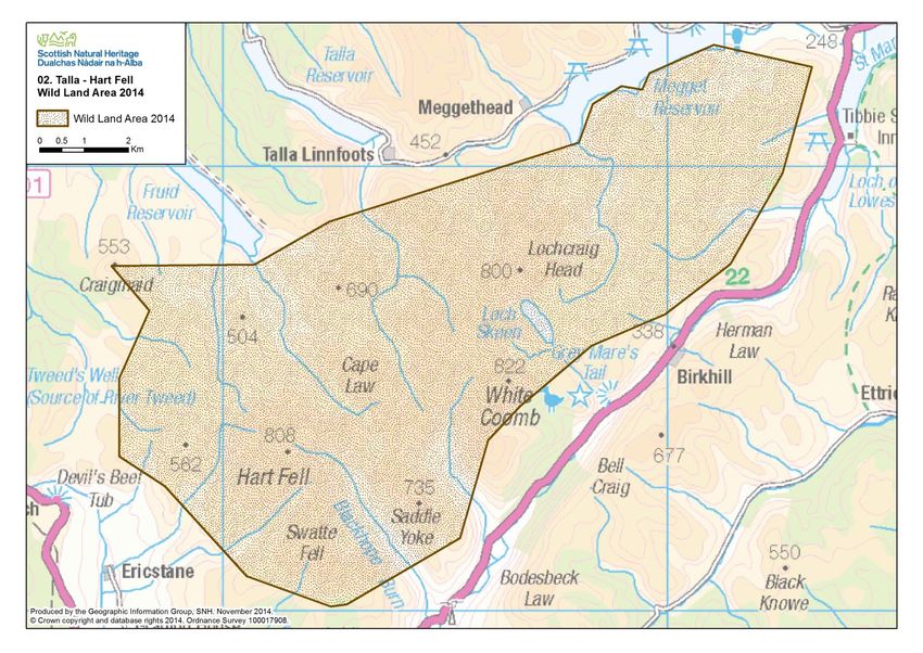
Talla - Hart Fells Wild Land Area - Nature Scot
←
→
Page content transcription
If your browser does not render page correctly, please read the page content below
Description Wild Land Area – 2017

02
     Talla – Hart Fells
      Wild Land Area

                    1
Description Wild Land Area – 2017
Context
Tall - Hart Fells is one of only three WLAs to the south of the Highland Boundary Fault, all of which are
relatively isolated and small in extent (this WLA is 93 km2). Lieing to the north of Moffat, the closest
WLA to Edinburgh and within 2 hours of much of the Central Belt, on the boundary between the Scottish
Borders and Dumfries and Galloway, it forms an elongated triangle of upland (some 17 km long and up
to 9 km at its widest point), between the larger glens of the Megget Water to the north and the Moffat
Water to the south.
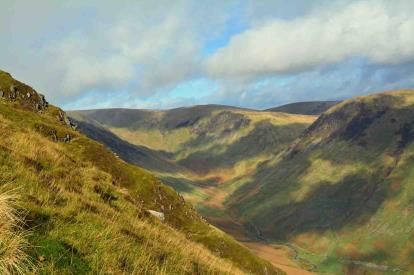
It consists of a range of rounded moorland hills which are incised by several deep clefts and steep-sided
glens. From the adjacent public roads, the WLA is mostly experienced as a simple, open moorland
backdrop which contrasts strongly with the more diverse settled glens that surround it. Where these
glens are narrow, for example along the Moffat Water, views towards the WLA are often reduced to
glimpses, whereas from the west, the wider glen of the River Annan allows more continuous views
towards the large mass of Hart Fell. From the north, the Talla, Fruid and Megget reservoirs form obvious
human elements, but allow striking views across the water towards the moorland hills.
There are a number of established walking routes, including the horseshoe ridge walk to the Corbett of
Hart Fell. White Coomb (another Corbett) and Lochcraig Head (a Donald), are also well publicised
destinations featuring rugged terrain and the proximity to the Central Belt and Cumbria makes the area
readily accessible to hill walkers.
NTS manages Loch Skeen and the Tail Burn which feeds the Grey Mare’s Tail waterfall, celebrated by Sir
Walter Scott. The route to the loch past these falls is well marked by a constructed path that leads from
the designated car park beside the A708, climbing 275 m to Loch Skeen. NTS removed the visitor centre
at Grey Mare’s Tail in late 2009 as it was considered a ‘permanent and unnecessary visual intrusion to
what is a spectacularly beautiful part of the countryside’.i
Borders Forest Trust owns the Carrifran Wildwood, which lies to the south west of Grey Mare’s Tail. In
2013 the Trust secured possession of part of the adjacent Talla and Gameshope estate, which will also
be managed for conservation. Within Dumfries and Galloway, an area that includes Black Hope and Loch
Skeen is designated as the Moffat Hills Special Area of Conservation, as it contains some fine examples of
upland vegetation.
The landscape and scenic value of the area is recognised by both Councils. Within Dumfries and
Galloway it lies within the Moffat Hills Regional Scenic Area (RSA) and within Scottish Borders it forms
part of the Tweedsmuir Uplands Special Landscape Area (SLA). The SLA citation notes that ‘This is a
highly scenic area of dramatic landform, and has a significant degree of wildness. The more rugged,
rocky summits in particular have a strong sense of remoteness, with little overt human influence on the
landscape’.ii
Although this WLA is surrounded by glens where the influence of human activity is strong, the steepness
of the valley sides allows strong visual links to be made to the Ettrick Hills to the south and the
Tweedsmuir Hills to the north, which often appear to form part of the same area of wild land. In places
the relatively small extent of the WLA is not always obvious from within, concealed by the complex
topography.
2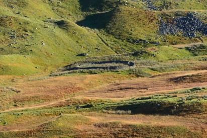
Description Wild Land Area – 2017
Key attributes and qualities of the wild land area
Rounded moorland hills, deeply incised by glens and deceptively challenging to traverse
These rounded hills are deeply incised by several steep-sided
glens, ravines and corries. Very steep slopes, combined with
large areas of deep bog at lower levels, on bealachs and on the
flatter tops make access more physically challenging than their
rounded appearance suggests.
Once climbed, access across the drier hill tops is easier,
although many of the upland routes are pathless, making
navigation on the rounded summits and plateaux harder,
consequently increasing the sense of risk.
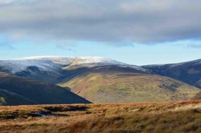
Although not as high as mountain ranges further north, parts
are very exposed, with arresting views into steep-sided glens
and glacially sculpted corries which contribute to a sense of
naturalness.
From the glens and corries and within some lower-lying parts of
the flatter tops, there is a stronger sense of enclosure and a
focus on nearby detail, such as the hummocky topography
formed by fluvio-glacial deposits, giving a greater sense of
remoteness and sanctuary.
A strong perception of naturalness that contrasts with the surrounding forest
plantations
A rich mosaic of rough grass, heather, bracken and bog
vegetation covers most of the WLA, with montane grassland on
higher slopes. Exposed rock outcrops, fast flowing burns and
waterfalls also contribute to the strong sense of naturalness.
Sheep grazing is evident in places, with some stock fences and
ATV tracks. These indicate contemporary land use and
introduce human artefacts, but are not sufficiently widespread
to noticeably affect the overall sense of naturalness.
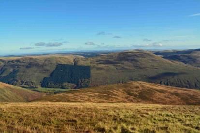
Some small forest plantations lie on the slopes above the
Chapelhope Burn and there are other plantations, just outwith
the WLA. These are mostly along the hillsides above the Moffat
Water and the largest is at Emblem Brae. The rectangular
conifer blocks can be seen from some south-facing hillsides,
where they contrast strongly with the colour and rounded form
of the moorland slopes and detract from the sense of
naturalness, sanctuary and remoteness. These effects are
limited by the steepness and complexity of the moorland
slopes, which restricts the overall visibility of the plantations.
From the tops and upper slopes there are longer, more widespread views to more distant forest
plantations. Those on the Ettrick Hills and to the south of Tweedsmuir are noticeable, with extraction
tracks and areas of clear fell visible. Even where seen at a distance, these extensive plantations can
diminish the sense of remoteness and sanctuary of the interior.
3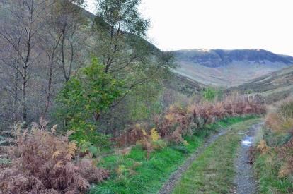
Description Wild Land Area – 2017
A large area of native tree planting within Carrifran Glen has a
positive effect on the sense of naturalness, accentuating the
rugged nature of the open moorland hills visible above. Some
tree shelters are evident and fencing around the planted area
emphasises the woodland edge. These introduce human
artefacts that detract slightly from the sense of naturalness,
although these effects are likely to diminish as the trees grow.
A well-defined area of wild land that contrasts with the surrounding glens, but with
strong visual links to adjacent hills
The WLA is surrounded by larger glens that contain roads, settlement, forest plantations, improved fields
and other signs of human activity. From the adjacent public roads, the WLA is mostly experienced as a
simple, open and rugged moorland backdrop, which contrasts with these more diverse, enclosed,
managed and settled glens. From the glens of the Moffat Water and, to a lesser extent, the Megget
Water, the steep sides tend to limit views to glimpses, often along the smaller tributary burns that incise
the hills, such as at Black Hope and Carrifran. Although from the west, the wider glen of the River Annan
allows more continuous views towards Hart Fell and White Coomb, the interior is generally screened
from view by the outer slopes, so that the extent of the WLA is
not obvious from outside.
The influence of these settled glens quickly diminishes towards
the interior. From within the hills, the steepness of the valley
sides and complex topography often conceal views of the
settled glens and allows stronger visual links to be made to the
Ettrick Hills to the south and the Tweedsmuir Hills to the north,
which can appear to form part of the same WLA.
Within the lower-lying parts of the interior, the complex hill
topography often prevents views of surrounding human
activity altogether, so concealing the extent of the WLA and
providing a stronger sense of remoteness and sanctuary, than the proximity to main roads would
suggest, notably around Loch Skeen, for example.
Few human artefacts, mostly historic settlements that are restricted to sheltered glens
Most habitation was in the past concentrated along the sheltered glens, leaving the uplands relatively
undeveloped. Some dwellings and agricultural buildings at
Winterhopeburn and Syart are accessed by constructed tracks
which have a localised effect on the sense of remoteness, but
are not extensively visible.
There are very few other human artefacts within this WLA. The
steepness of the landform means that tracks are mostly
restricted to the base of the minor glens that penetrate the hills
and do not provide through routes. These tracks are generally
well integrated and often grassed over, so reducing their effect
on the wild land qualities.
4
Description Wild Land Area – 2017

Stone sheep shelters (stells), enclosures, shielings and dykes are
common within these glens, providing reminders of past use of
the land. They are usually small, isolated human elements and
some are ruins, only just discernible as human artefacts, with
little consequent effect on the sense of remoteness and
sanctuary.

Although there are few human artefacts within the WLA, several large, operational wind farms are
visible from upper slopes and hill tops. Clyde and Glenkernie are the closest of these, approximately 10
km to the west and 14 km to the north of Hart Fell respectively. These have a cumulative effect,
particularly where the turbines are highlighted against the backcloth of dark forest plantations, reducing
the sense of remoteness and sanctuary of the interior.

Endnotes
i
     NTS (2010). Grey Mare’s Tail Nature Reserve Newsletter
ii
     Scottish Borders Council (2012). Supplementary Planning Guidance. Local Landscape Designations.

Site assessment carried out October and November 2013

                                                                 5

You can also read