40 Cape Wrath Wild Land Area
←
→
Page content transcription
If your browser does not render page correctly, please read the page content below
Description of Wild Land Area – 2015

40
       Cape Wrath
      Wild Land Area

                      1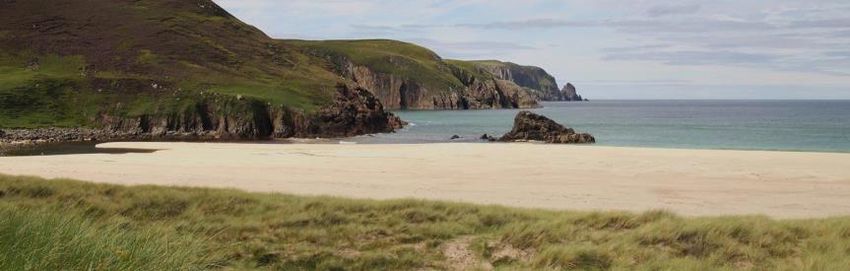
Description of Wild Land Area – 2015
Context
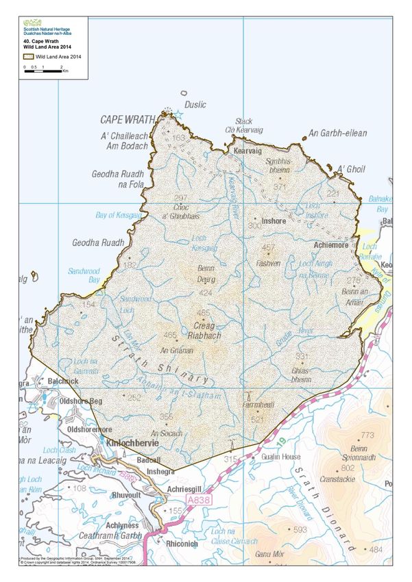
This Wild Land Area (WLA) extends 226 km2 across rolling hills and peatland of Sutherland, the most
northern mainland WLA and one of only three mainland areas that are partly defined by the coast.
Edged on two sides by the sea with a spectacular coastline of cliffs and beaches, inland it is flanked by
main roads to the east and south, and lies relatively distant from large population centres.
Cape Wrath or Am Parbh (commonly known as ‘the Parbh’) is renowned for being the furthest north-
west extremity of mainland UK, with its name derived from the Norse word ‘hvarf’, meaning turning
point. The end of the promontory is marked by the Cape Wrath lighthouse, while its margins are
delineated by the sea on the south west, north west and north east sides, and the Kyle of Durness and
River Dionard glaciated valley to the south east. The cape forms part of the North West Highlands
Geoparki, with its Torridonian sandstone and Lewisian gneiss most clearly evident along the coast,
including the highest sea cliffs on the British mainland at Clò Mòr.
The northern part of Cape Wrath and its coastal waters are used for training by the Ministry of Defence,
during which times public access may be limited. In contrast, the John Muir Trust own and manages the
southern part of the WLA, including the renowned Sandwood Bay and Am Buachaille sea stack. It
promotesii this area as ‘a special wild place of awe-inspiring coastal beauty…’ The remaining land within
the WLA is used mainly for deer and sheep grazing, with the latter being particularly prevalent closer to
the crofting communities of Blairmore and Oldshoremore.
The reputation of Cape Wrath draws many visitors. Many of these access the area in season via the
small passenger ferry from Keoldale and then a minibus to and from the Cape Wrath lighthouse (a trip
marketed as going ‘to the edge’iii). Elsewhere visitors walk (or cycle in smaller numbers) the four-mile
path from Blairmore in the south to Sandwood Bay. Some cross the entire WLA north - south along the
unmarked ‘Cape Wrath Trail’iv and some stay at the bothies at Kearvaig in the north and Strathchailleach
and Strathan in the south. A high number of runners also visit the northern part of the area once a year
whilst taking part in the Cape Wrath Challengev marathon.
The scenic value of the Cape Wrath coast is recognised by its inclusion within the Oldshoremore, Cape
Wrath and Durness Special Landscape Area. The descriptionvi for this area includes reference to
‘extensive, unbroken stretches of remote coastline dominated by high cliffs and related landform features
including stacks, caves and ravines’ and ‘extreme difficulty of access to much of the area’.
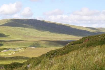
The WLA interior is not easy to see from its edges, due to screening by the outside hill slopes and sea
cliffs. However, the south eastern margins are seen forming the western slopes of the striking glaciated
U-shaped glen between Gualin and Keoldale, as well as forming the hill backdrop to views west across
the Kyle of Durness, experienced by many whilst travelling along the A838 road. To the east of this glen
lie the prominent rocky mountains of Foinaven and Cranstackie, which form part of the Foinaven – Ben
Hee WLA (33). The greater height of these mountains compared with the Cape Wrath hills means that
their tops offer elevated views over the WLA; whilst, in reverse, they are sometimes seen from the WLA
as mountain foci that protrude up above the intervening hill horizons.
2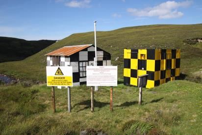
Description of Wild Land Area – 2015
Key attributes and qualities of the wild land area
Peripheral and remote area, with a strong sense of isolation and challenging access
This WLA is difficult to access as it is surrounded on two sides by steep cliffs and exposed seas, on the
third side by the Kyle of Durness and a deep glaciated glen, and on the forth by extensive peatlands.
This contributes to a strong sense of isolation and remoteness (more than the actual distance from
public roads and settlements might suggest). It also means that access to the area requires great effort
and is dependent on the vagaries of the weather and the ability to land boats if crossing the Kyle of
Durness. These access constraints, and particularly the very strong influence of the sea and weather,
amplify the sense of naturalness.
The remoteness of the area means that few people visit the
majority of the WLA and there is a corresponding strong sense
of solitude and sanctuary. Nonetheless, there are specific
times and places when and where there are relatively high
numbers of visitors, including the main routes into the area
(via the passenger ferry from Keoldale and minibus, and along
the path from Blairmore) and at the Cape Wrath lighthouse
and Sandwood Bay. In these locations, the sense of solitude
and sanctuary can be temporarily diminished during busy
times.
The northern track to the lighthouse and the southern path to
Sandwood Bay appear as obvious human artefacts.
Nonetheless, their low-key character and the significant time
and effort required to travel along them, mean that they do
not overwhelm the prevailing sense of remoteness.
Access off-path across the interior of the WLA is very difficult and physically challenging. This is partly
because, although the area is not very high in elevation, its traverse requires negotiating a range of
bogs, pools, peat hags and burns. Access around the coast is also difficult due to very steep slopes along
the edge and a scalloped landform of promontories and inlets. This combines with prevailing exposure
and a lack of landmarks and difficult navigation to result in a perceived high risk.
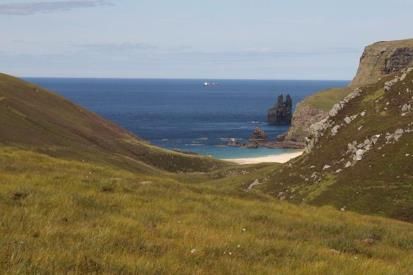
Spectacular coastline, with towering cliffs, sandy beaches and sea stacks, strongly
influenced by the dynamic character of the sea
This WLA is strongly influenced by the sea. This is primarily because this is never far away, but its
juxtaposition also increases the perceived extent of the area as well as the sense of naturalness,
influenced by the activity and sound of waves and sea birds. Geomorphological features such as high
cliffs and sea stacks also contribute to the sense of naturalness, as well as appearing arresting in contrast
to the simple, horizontal sea expanse.
The towering cliffs are extremely rugged and create a strong physical edge that restricts access and leads
to a perceived high risk. They are seen most clearly from the sea or where there is an intersecting glen
because, from the cliff-tops and area above, they are hidden by ‘dropping away’ below. The
3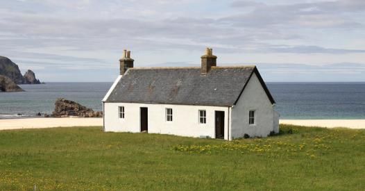
Description of Wild Land Area – 2015
inaccessibility of the cliffs and limited visibility of the coastal edge are two reasons why the beaches
within the area tend to form the focus of activity and views.
Some of the beaches, such as Kearvaig and Sandwood, possess large expanses of light, bright sands and
dunes. In combination with the wide expanse of the adjacent sea, and in contrast to the surrounding
high cliff edges, these appear awe inspiring. Some coastal inlets also offer local shelter and a sense of
sanctuary in contrast to the prevailing exposure of the cape.
Where shelter combines with better drained ground extending inland from the bays, past settlement is
often evident, including historic buildings, enclosures and lazy beds, as well as a brighter green sward
that is still grazed by sheep in some places. The small scale and low-key siting and character of these
features mean their effects tend to be localised.
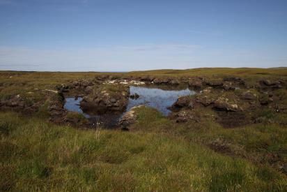
Subtle interweaving of rounded hills, peatland and cnocan across the interior that
seems extensive, but in which it is difficult to navigate and estimate scale
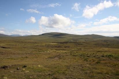
Away from the coast, the WLA comprises a subtle mix of sweeping peatland and rolling hills, with a small
area of rocky cnocan in the south. This area’s strong simplicity, horizontal emphasis, wide open expanse
and exposure at a broad scale contribute to the perceived awe.
The interior hill and peatland slopes seem interwoven with no obvious foci. This means it can be very
difficult to navigate, increasing the sense of risk that is already high due to the rugged ground cover at a
local level which includes bogs, pools and peat hags. In combination with simple vegetation cover and a
typical lack of size indicators, this also means that it can be very difficult to judge distance, so that the
area often seems more extensive than its actual dimensions. The exception to this effect occurs along
the wide U-shaped glen between Gualin and Keoldale, where the hills are steeper and scale reference is
provided by adjacent human elements.
4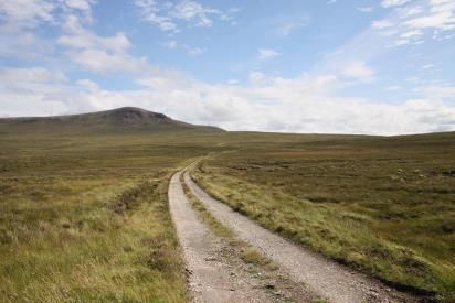
Description of Wild Land Area – 2015
A simple peatland interior with a prevailing sense of ‘emptiness’, although there are
some concentrations of military artefacts and infrastructure
Within the interior of this WLA, there is a prevailing lack of human artefacts and evidence of
contemporary land use and an absence of conifer plantations, so there is a sense of ‘emptiness’ in
addition to remoteness and perceived naturalness and sanctuary. With few visitors or paths in most
places, there is also a strong sense of solitude.
In contrast to these prevailing attributes, there are some
concentrations of human artefacts that diminish the wild land
qualities. These include structures in the north associated
with the access road and lighthouse that have cumulative
effects, as well as two elevated telecommunication masts near
the eastern edge of the WLA (upon Farrmheall and Meall na
Moine), some agricultural fences in the south and some
military structures dispersed within the northern half of the
WLA that include warning signs, buildings, and a long barbed-
wire fence.
Endnotes and select references
i
More information is available at http://www.northwest-highlands-geopark.org.uk/
ii
John Muir Trust (2012) A guide to Sandwood (Seannabhat). Pitlochry, John Muir Trust.
iii
Taken from leaflet for minibus trip to Cape Wrath. Available at www.capewrath.org.uk.
iv
More information is available at http://capewrathtrailguide.org/
v
More information is available at http://www.capewrathchallenge.co.uk/The_runs.html
vi
The Highland Council (2011) Assessment of Highland Special Landscape Areas. Inverness, The Highland Council.
Site assessment carried out August 2013
5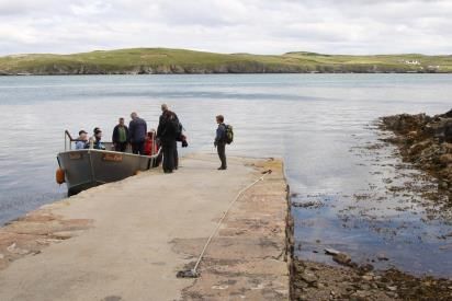
You can also read