The Bastidon Trail La Palud-sur-Verdon - Chemins des parcs
←
→
Page content transcription
If your browser does not render page correctly, please read the page content below
PNR Verdon
In partnership with
OT la Palud sur Verdon - Rougon
The Bastidon Trail
La Palud-sur-Verdon
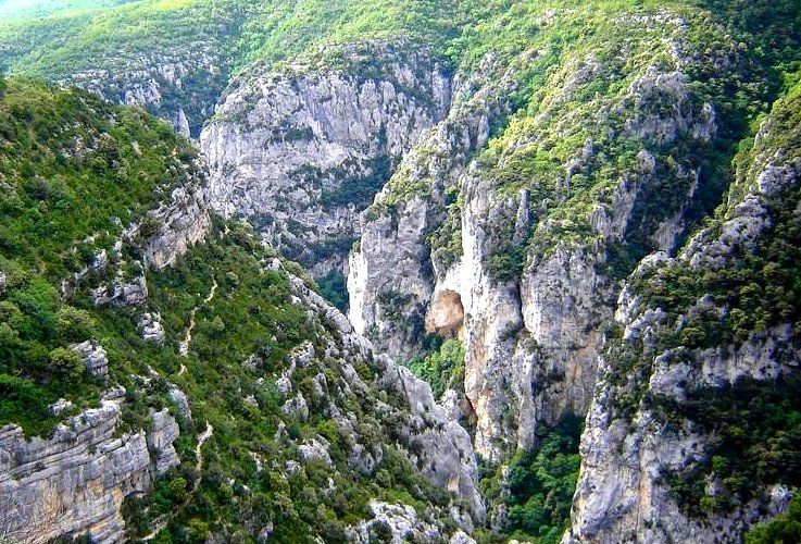
Le Bastidon (DR)
A contrast of the superheated garrigue Useful information
of the Verdon from the shady and cool Practice : WALKING
forest of the ubac of Barbin, you will
walk in a wild and grand place. Duration : 7 h
"One of the most beautiful hikes in the region despite Length : 15.3 km
1,000m of vertical drop! For almost 2 hours by the Bastidon Trek ascent : 871 m
trail, I was able to discover, along the Verdon, the diversity
of this sector. Accessible despite some wired passages. I Difficulty : Difficult
loved the viewpoint at the Mayreste lookout on the Grand
Type : Boucle
Canyon du Verdon, the pine and beech forests that cover
the mountain of Barbin." Themes : A lookout, a
viewpoint, Fauna, Flora
02/17/2021 • The Bastidon Trail 1/8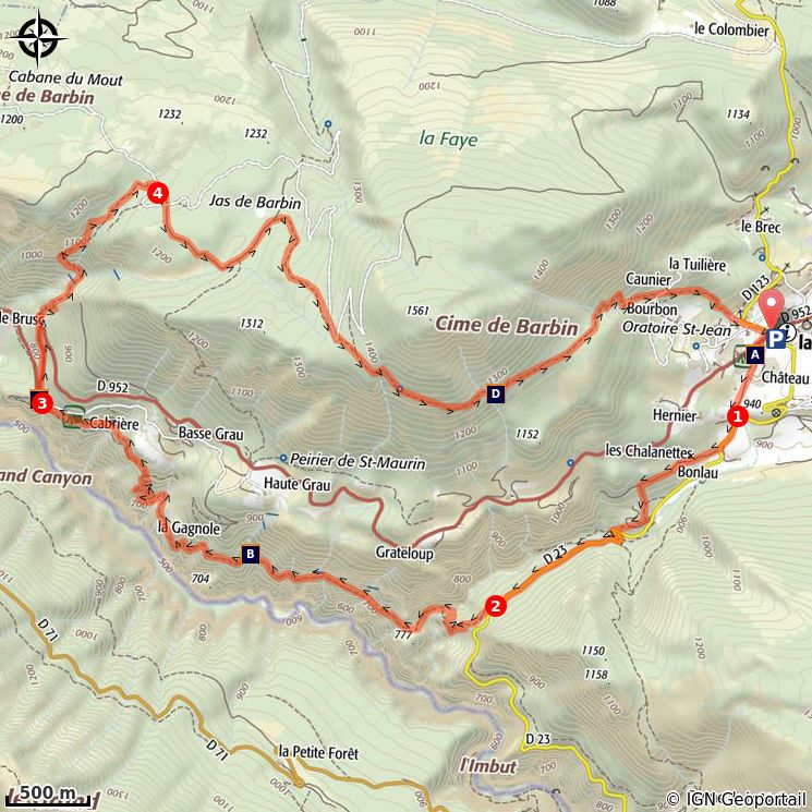
Trek

Departure : From the village of La Palud-sur-Verdon
Arrival : Village of La Palud-sur-Verdon
Markings : PR GR®

Exit the village by the D952 towards Moustiers-Sainte-Marie. At the oratory, turn left to go along the
campsite, then leave the road to go in front, on the trail.

1- Join the ridge road. Follow it on the right for about 250m. At the pumping station, turn right in the
direction of Bonlau. Go behind the building. After the well, go down on the left. Farther, follow the ridge
road for about 1km.

2- Leave the road and descend on the right by the Bastidon trail. Join the Mainmorte ravine. Then go back
up to find the neck. Continue to flank. After crossing the ravine of Ferné exit the gorges by the path. Pass
several ravines (the delicate passages are secured!). Turn left at the Mairestre belvedere.

3- Go up to the belvedere, then back and go along the D952 and then leave it to go straight into the first
corner. After a series of winding roads, turn left into the Brusc valley. Climb into a rocky gully and exit into
the Grinhan ravine. Join the GR®4 trail.

4- Turn right and follow the red and white markings of GR®4. Cut the turn of the trail, descend into the
ravine and continue until the Jas de Barbin crossroad. Continue along the trail to the right under the
woods (the trail changes slope). Continue on the mountainside of Barbin and after the passage of a ruin
and an enclosed river, descend following the winding path. At the foot of the hill cross a trail and join the
village road below. At the oratory, go straight on to reach La Palud.

                                            02/17/2021 • The Bastidon Trail                                  2/8
On your path...
La Palud-sur-Verdon and the castle of Its Highness (B)
Demandolx (A)
Belvedere of Mayreste (C) Fine lavender (D)
02/17/2021 • The Bastidon Trail 3/8All useful information
Advices
Avoid high summer temperatures, leave early. Take: 3L of water per person, a hat, and walking shoes
Be wary of certain wired passages (handrail). Not recommended for persons prone to vertigo.
Altimetric profile
Min elevation 703 m
Max elevation 1375 m
Transports Access
Limitons les déplacements en voiture, pensons 19.6km southeast of Moustiers-Sainte-Marie on
aux transports en commun et au covoiturage. the D952.
Tous les transports en commun sur
www.pacamobilite.fr
Advised parking
Along the D23 in the village
02/17/2021 • The Bastidon Trail 4/8Information desks
OT la Palud sur Verdon - Rougon
Le Château, 04120 La Palud-sur-Verdon
office-tourisme@lapaludsurverdon.com
Tel : +33 (0)4 92 77 32 02
http://www.lapalud-verdontourisme.com/
House of the Verdon Regional Nature Park
Domaine de Valx, 04360 Moustiers-Sainte-Marie
info@parcduverdon.fr
Tel : +33 (0)4 92 74 68 00
http://www.parcduverdon.fr/
02/17/2021 • The Bastidon Trail 5/8On your path...
La Palud-sur-Verdon and the castle of Demandolx (A)
The Demandolx, local lords, wished to develop a pleasure residence. Five
centuries later, they began to build the contemporary castle with its four round
towers. In 1789 (the Revolution) the building was completed and it came back
to the inhabitants. It was therefore inhabited for nearly two centuries by a
dozen owners before the town council decided to buy it to dedicate it to the
environment. It was restored not long time ago, and it now houses the Maison
des Gorges du Verdon.
Attribution : Stefano Blanc - PNR Verdon
Its Highness (B)
The trails of the Verdon gorges will give you the opportunity to discover four
endemic species of the Verdon. Honour where honour is due, on shaded dry
walls, a small fern that grows by molding on the roughness of the rock. It is the
Jahandiez Asplenium, named after a botanist from the Var in the beginning of
the 20th century, to whom the “describer” of the species has dedicated it.
Attention, pleasure of the eyes only, its rarity and originality deserve complete
protection.
Attribution : Stefano Blanc - PNR Verdon
Belvedere of Mayreste (C)
The Bastidon trail stands halfway up the gorges which allows it an almost "from
the inside" discovery, on the cliff side. We are here in the heart of the rock and
its natural vegetation. At the belvedere of Mayreste, you can look over some of
the gorges and evaluate the distance between the road and the river. Then you
get to the heart of the matter.
Attribution : DR
Fine lavender (D)
Lavandin with its “rustic" fragrance is a sterile hybrid of "broad leaved"
lavender and "fine" lavender. It is used in detergents and other cleaning
products. Fine lavender is the only prized by perfumers. To recognize them,
your nose will remain the best way since the botanical differences are not clear
and fairly relative: a ramified flower stalk and developed inflorescence for
lavendin, a single stalk and short inflorescence for fine lavender.
Attribution : Stefano Blanc - PNR Verdon
02/17/2021 • The Bastidon Trail 6/8• En aucun cas les auteurs des contenus de ce site ne sauraient être tenus pour responsables de
problèmes ou d'accidents sur les itinéraires cités.
• Cependant, nous comptons sur vous pour signaler toutes contradictions importantes entre cette
fiche et le terrain.
• Pensez également à signaler les éventuels problèmes rencontrés pendant votre balade sur http://
sentinelles.sportsdenature.fr (erreur de balisage, panneau défectueux, pollution, conflit d'usages…).
• La vente de cette fiche est autorisée au coût d'impression.
• Ne pas jeter dans la nature.
L'outil Geotrek a été financé par l'Union européenne, le Parc national des Ecrins et le Parc national du
Mercantour.
Le projet Chemins des Parcs est financé par la Région Provence-Alpes-Côte-d'Azur et les Parcs naturels
régionaux des Alpilles, de Camargue, du Luberon, du Queyras et du Verdon.
Ce projet partenarial rassemble également le Comité Régional du Tourisme, les agences départementales
de développement touristique, les offices de tourisme et les syndicats d'initiative.
• The authors of this website will in no case be held responsible for problems or accidents on the
routes mentioned.
• We count on you to point out any inconsistency between this content and the field itineraries
• Please report any problems encountered on the routes (route marking problems, defective panels,
pollution, conflict of uses ...) on http://sentinelles.sportsdenature.fr
• The sale of this sheet is authorized at the cost of printing
• Please don’t litter
The Geotrek tool was funded by the European Union, the Ecrins National Park and the Mercantour
National Park.
The Chemins des Parcs project is funded by the Provence-Alpes-Côte-d'Azur Region and the regional
nature parks of Alpilles, Camargue, Luberon, Queyras and the Verdon.
This project was developed in partnership with the Regional Tourism Committee, the departmental tourist
development agencies, and tourist offices.
02/17/2021 • The Bastidon Trail 7/8Avec le soutien de
02/17/2021 • The Bastidon Trail 8/8You can also read