The Behind-the-scenes Story of the Thailand Cave Rescue
←
→
Page content transcription
If your browser does not render page correctly, please read the page content below
ARTICLE
HOW GIS AIDED THE RESCUE MISSION IN THAM
LUANG NANG NON
The Behind-the-scenes Story of the
Thailand Cave Rescue
As the world became captivated
with the challenge of rescuing
the 12 soccer boys and their
coach from deep within the
Tham Luang Nang Non cave
system in Thailand, GIS was
applied to understand and
share knowledge about the
cave. The Department of Mineral
Resources (DMR) collaborated
with Esri Thailand Ltd. and GIS
Ltd. to create a team of
mapping and GIS experts at the
Geohazard Operation Center.
This team supported the rescue
mission by applying GIS
technology to create cave
passage maps and analyse the
topography and hydrology of
the area.
With expertise in geology, DMR was expected to prepare maps and data.
Unfortunately, at the outset of this mission qualified data was not available.
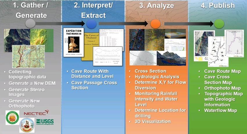
The first step was to gather and generate topographic and geologic data,
interpret and extract cave information, and analyse the cross section,
topography and hydrology of the cave.
DMR closely collaborated with Department of Natural Parks, Wildlife and
Plant Conservation (DNP), Royal Irrigation Department (RID), Disaster
Prevention and Mitigation Department, Royal Thai Navy and others. Many
experts and rescuers from every part of the world joined the mission.
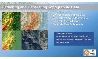
Gathering Data
Early maps shared by others on social media were found to lack the accuracy needed for a real operation. The first task of the GIS and mapping team was to
gather topographic maps, high-resolution Digital Elevation Model data from SRTM and other sources, and essential GIS Layers including the 2D shape of the cave.
Geological and mapping experts considered the absolute and relative accuracy of all topographic data together.
With support from the Royal Thai Survey Department (RTSD), high-resolution orthoimagery and stereo pair models from 2007 aerial images were used to search
the cave exterior for alternative entrances. Then 2D maps, cave cross-section maps, and 3D perspective views of the area were generated and distributed to the
many organisations involved in the form of paper maps and links to ArcGIS Online.
Cave map details initially came from the “Expedition Thai-Maros 1986 and 1987” cave survey that was conducted by French surveyors, however, the cave cross-
section map from 1987 was initially missing. The volunteer French translator team from the Faculty of Arts at Chulalongkorn University translated this information.
Dr Martin Ellis, author of the book The Caves of Thailand Volume 2: Northern Thailand sent it, and it too was translated.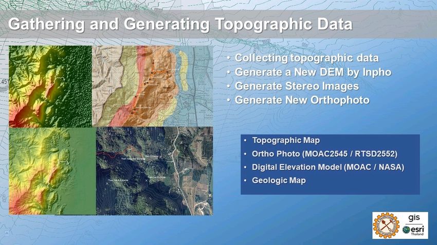
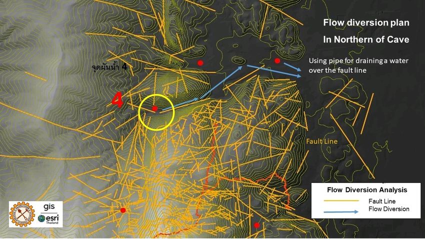
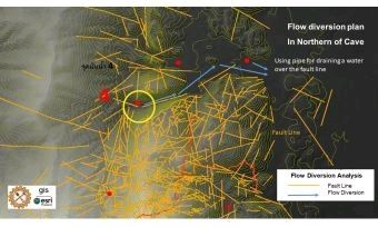
Next, the team discovered that the “Cave Registry Data Archive” from the British Cave Association contained a 2014-2015 survey with data in SRV format. The SRV
files were converted into 3D local coordinates system using the GPS reference in both X, Y and Z value. The elevation level of the cave was then generated, and the
cave was visualised in 3D. This 3D cave map was distributed and widely used by the field teams, including the British Cave Surveying team, Thai Navy Seal team
and Department of Disaster Prevention and Mitigation staff.

The dive search team had a very difficult task to work in the dark and flooded cave with no guide, working back and forth through the cave for days before
discovering the trapped boys. With support from Dr Ellis, the cave survey map of 1987 with cross sections was found. The mapping team registered the
dimensions of the cross-section openings and the distance between the sections on a map.

“With this map, the divers could plan and operate their mission effectively,” said Songkorn Siangsuebchart, senior technical consultant, GIS Company, Ltd.

The mapping team also supported the rescue team by calculating the volume of the cave to determine how much oxygen remained. This became an important
input to the operations when the boys were found, particularly for section 29-30 where the boys and their coach were trapped.

Diverting the Water Flow
Tham Luang cave is part of a karst limestone mountain ecosystem. When it rains on the mountain, water flows into the subterranean aquifer system and springs
out as streams and rivers. With heavy rain in the area, the water level in the cave rose rapidly making a safe rescue impossible.

Groundwater experts drilled and pumped the water at the main entrance. With the pump working all day and night, they realised that they could not keep up with
the enormous volume of water flowing through the mountain during the rainy season. The mapping team was tasked with creating a flow diversion model to limit
the water entering the cave. Using Arc Hydro, the team worked against the clock to calculate the basin, water flow direction, and water accumulation using the
SRTM DEM and a new DEM created from Royal Thai survey aerial images.

“We had to calculate the basin, water flow direction, and accumulation using a digital elevation model, geological detail and details about the dense forest cover in
order to identify the origin of significant flows of water inside the cave,” said Chanist Prasertburanakul, senior aerospace mapping manager and team leader of GIS
Company, Ltd. and Esri Thailand.
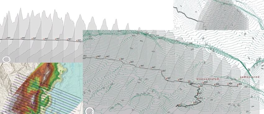
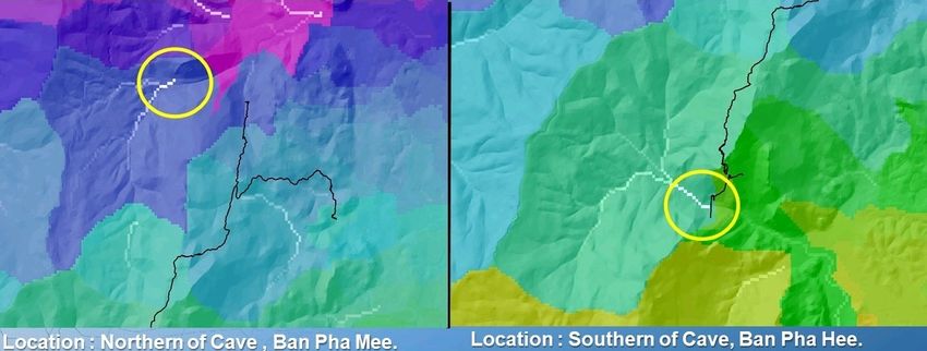
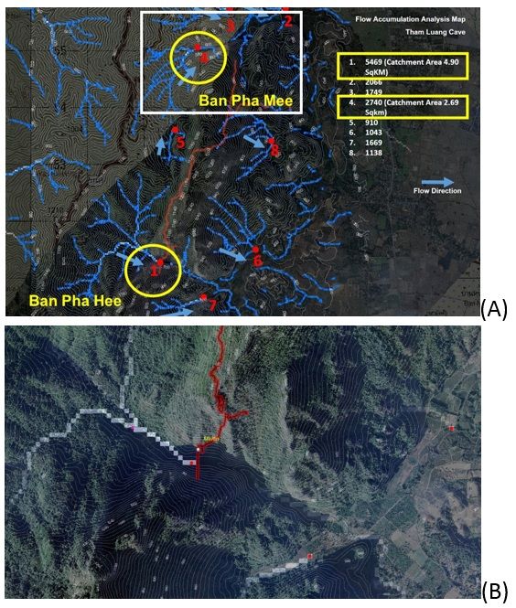
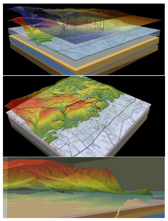
The results of basin analysis showed the drainage area of Ban Pha Hee south of the cave is 4.90 sq. km and in the north at Ban Pha Mee it is 2.69 sq. km. After the
flow accumulation model was performed, the team found two sinkhole infiltration points for each of these drainage areas. The Thai Navy SEAL team confirmed this
calculation, relaying that turbulent flows were entering the cave from both the north and south.

The x,y coordinates of both sinkholes were sent to the ground teams for inspection. The ground teams comprised of DNP and RID staff surveyed the origin of
water and examined the inflow and outflow.

DMR tasked the ground teams with diverting the flow of water. The ground teams first built a check dam at Ban Pha Mee to slow the water flow and used a very
long pipeline to divert the flow of water into rice paddy fields. By 1 July, this diversion reduced the inflow from the north by more than 50 percent, however, the
water levels in the cave were still high.

Next, the Ban Pha Hee model was run to divert the waterflow in the south. By 4 July, up to 10,000 cubic metres of water was diverted. Additional cracks and
sinkholes were found and dammed, and the water level inside the cave was reduced significantly.

Determining Locations for Drilling
DMR considered the possibility of drilling into the cave to safely extract the trapped team. The topographic and geologic information were used to determine the
best location to drill.

The cave is approximately 446 metres beneath the limestone and shale rock mountain surface. A cross section was generated along the cave from north to south
to estimate the distance between surface and the cave.

ArcGIS Pro was used to calculate 3D distances from potential drill points to the cave interior, calculating inclination angle and azimuth. The distance and angle of
potential locations were sent to geological engineers for inspecting the possibility of drilling in each position.

Geologist and GIS experts not only produced useful maps, they also created and integrated spatial information to present to the rescue operation team and
decision makers. 3D maps were generated using ArcGIS Pro to help the officers and ground team to identify locations of interest around the cave area. When the
hydrologic layers were overlaid on the 3D perspective, it allowed everyone to understand the spatial relationships of the water system.

“Although the roles of geologists and GIS experts who created these useful maps for resolving the crisis are not as prominent as those who worked in the field,
the geological maps of the cave structure was crucial to resolving this crisis,” said Dr Somsak Wathanaprida, director of the Environmental Geology section,
Thailand Department of Mineral Resources.

The drilling operation was cancelled after the operation team decided to extract the boys and their coach using the dive teams.

Monitoring Water Levels and Rainfall Intensit
The rain forecast indicated that more rain would fall. After the two diversion dams and pipelines were constructed for both the north and south sections of the
cave, the rainfall and water level in the cave were continuously monitored.

The rainfall intensity data came from four rain stations installed by Thailand’s National Electronics and Computer Technology Center (NECTEC). The rainfall intensity
data for the past week was collected from the Thailand Hydro and Agro Informatics Institute website. The weather information was supplied by the Meteorological
Department. The water level information was supplied by the DMR ground team and Chiang Rai Department of Disaster Prevention and Mitigation staff inside the
cave.
The water level in cave was monitored hourly by the ground staff. DMR, GIS and Esri Thailand used ArcGIS to model the rainfall intensity distribution over the cave
area by using IDW-Inverse distance weight algorithms. This model, using spatial interpolation methods for estimating rainfall intensity over the geographic area,
illustrated that the depth of water decreased significantly after 4 July.

To summarise, GIS technology helped gather and generate topographic and geologic data; interpret and extract cave information; analyse
cross section, topography and hydrology to determine the origin of water; design the water flow diversion; monitor the water level and
rainfall intensity; understand the area using 3D visualisation; and distribute maps to the ground team.

“Not only were our tool and technology employed but also our experience, knowledge, dedication, determination and heart in this tough mission. At the moment
when all the boys were rescued it was so emotional – a miracle moment when the impossible becomes possible,” said Chanist.

"It was a wonderful moment when the Chiang Rai provincial governor announced that all the boys and their coach were rescued. We believed that all people around
the world were happy to know that they were safely rescued and soon back to their family." stated Songkorn.

“In someone's life, the opportunity to work is great but the opportunity to directly touch the world with that work is rare. The rescue of the Wild Boars soccer
team was a perfect match for me and my organisation. The experiences we gained yielded a lot of expertise for future tasks. We do not know what we will face in
the future, however, if we have enough information, colleagues and friends, and applicable tools, we believe we will go through everything well.” Commented Dr
Somsak.
Timeline of mapping in rescue mission:

    23 June 2018: 12 kids and their coach were trapped in the cave because of rising water
    24 – 27 June 2018 : The government and private agencies formed the search and rescue team. Many maps were distributed unofficially for the search and
    rescue mission.
    27 June 2018:
          Esri Thailand and GIS company decided to join the search and rescue mission with Department of Mineral Resources at Geohazard Operation office
          center.
          The search and rescue team in the field pumped the water out of the cave but there was no significant reduction of the water level
    28 June 2018:
          The reliable topographic data was required for spatial analysis. The team generated and gathered all required data such as cave track DEM, SRTM DEM,
          Orthophoto, Cave Line, etc. Then DMR distributed the produced maps, such as 3D map, mountain cross section map to other organisations in the field.
          The detail of the cave was translated from the “EXPEDITION THAI-MAROS 1986” and “EXPEDITION THAI-MAROS 1987” documents of French surveyors.
          But the detailed cave map of 1987 was missing.
    29 June 2018:
          The heavy rainfall caused rising the water level in the cave. The drainage basin, water flow direction, and flow accumulation were analysed from the
          updated DEM for determining the significant locations to divert the water flow. DMR insisted the field team; DNP, RID, and Royal Thai Army to divert the
          water flow.
          The Caves of Thailand: Volume 2: Northern Thailand by Martin Ellis was translated and the team found the cave survey by British surveyors in 2014-
          2015. Then the cave survey digital data of French surveyors in 1987 and British surveyors in 2014 and 2015 were found in the Cave Registry Data
          Archive of British Cave Association. There is the GPS (X,Y,Z) reference points in cave survey data of 2014 and 2015.
          The divers faced difficulties to get through the cave passage
    30 June - 1 July 2018:
          Efforts can be made to lower water levels through water diversion and by water pumping. The stone dam was constructed at the northern part of the
          cave and the 2.4 km pipeline was built to divert the water flow. This effort could maintain the water level of the cave. But the cave water level was not
          reduced.
          The missing detailed cave map of 1987 was sent from Martin Ellis. The 1987 detailed map contains the cave passage cross sections with the scale bar.
          This scale bar were georeferenced to get the real world dimension of the passage and the distance between the passage sections. This map was
          distributed to the dive team as a guideline for planning and operating their searching mission.
          There was the heavy rainfall forecast.
    2 July 2018:
          The 12 kids and a coach were found at Nom Sao Hill in the cave.
          The water level was rising because of the rainfall
          DMR insisted that the field team divert the water on the southern part of the cave
    3-4 July 2018:
          The field team diverted the flow by building more stone diversion dams and a 1.2 km pipeline upstream in the southern part of the cave. Based on the
          hourly records of the cave water level, the water depth gradually reduced significantly.
          The water level in the cave and rainfall were closely monitored.
          Oxygen levels in the cave reduced significantly.
    5-8 July 2018:
          Supported the drilling rescue option by analysing for the low slope surface (< 25 degree) area and calculating the vector distance between the selected
          area and the Nom Sao Hill
          Monitored the water level and rainfall intensity.
    9 July 2018:
          The first group including four kids were rescued.
          Monitored the water level and rainfall intensity of first day of rescue mission.
    10 July 2018:
          The second group including four kids were rescued.
          Monitored the water level and rainfall intensity of the second day of rescue mission.
    11 July 2018:
          The third group including 4 kids and their coach were rescued.
          Monitored the water level and rainfall intensity of third day of rescue mission.
          Mission Accomplished.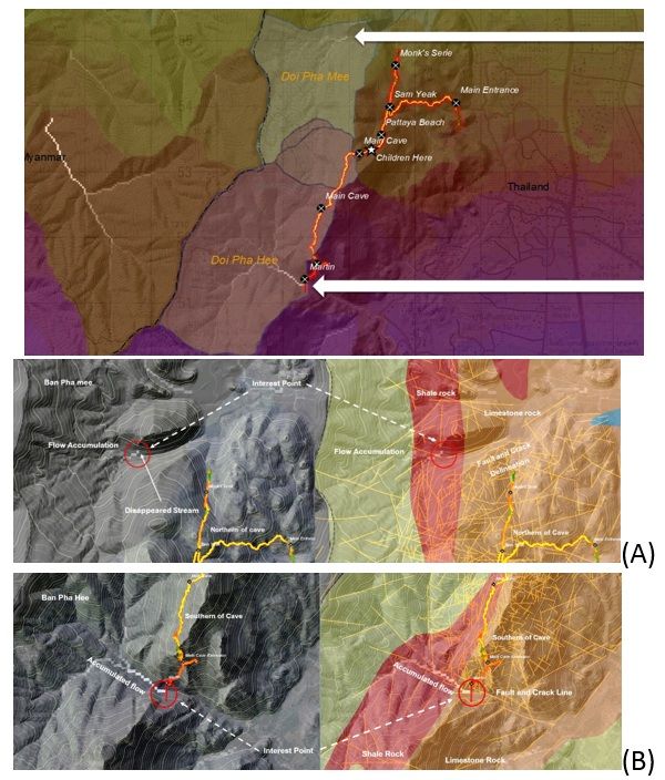
https://www.gim-international.com/content/article/the-behind-the-scenes-story-of-the-thailand-cave-rescue
You can also read