The Development of a National Fire Danger Rating System for South Africa
←
→
Page content transcription
If your browser does not render page correctly, please read the page content below

ENV-P-C 2000-073

     The Development of a
   National Fire Danger Rating
              System
         for South Africa

                                By:

Carla Willis, Brian van Wilgen, Kevin Tolhurst, Colin Everson,
     Peter D’Abreton, Lionel Pero and Gavin Fleming,

                             Prepared for
               Department of Water Affairs and Forestry
                               Pretoria
                                 by
           CSIR Water, Environment and Forestry Technology
                             P O Box 395
                               Pretoria
                                0001

                              July 2001
National Fire Danger Rating System                                                       July 2001

                                 ACKNOWLEDGEMENTS

The authors would like to thank Mandla Mehlomakulu, Dineo Moshe and Will Kgame for their
contributions to this report. A special thanks also to Emily Kgosana, Gill Allen and Karin Harding
for their hard work in the integration and formatting of this document. Rose Clark is gratefully
acknowledged for her proof-reading and editorial inputs, Bob Scholes for his formal review of the
draft report, and Fred Kruger whose critical review has greatly improved the content of this report.

The authors are especially indebted to all the stakeholders who contributed to the development of
the National Fire Danger Rating System and in particular to Johan Heine for his continued
involvement and support throughout this process.

                                This project was funded by
                     the Department for International Development, U.K.

                                                 i
National Fire Danger Rating System                                                            July 2001

                                      EXECUTIVE SUMMARY

INTRODUCTION

During 1998, South Africa passed the new National Veld and Forest Fire Act (Act 101 of 1998),
hereafter referred to as ‘the Act’. The Act provides for the prevention of veld, forest and mountain
fires through the deployment of a National Fire Danger Rating System (NFDRS). Such a system
does not exist at a national level at this stage, although localised fire danger rating systems are
used in some regions. The Department of Water Affairs and Forestry (DWAF) therefore contracted
the CSIR to develop a NFDRS for South Africa. The NFDRS was developed by a team of experts,
in consultation with the Veld and Forest Fire Committee of the Department of Water Affairs and
Forestry and several key stakeholders.

This report provides an account of the process followed in the selection of an appropriate NFDRS
for South Africa and provides an overview of the main components of such a NFDRS. It briefly
describes the systems used nationally and internationally, as well as a brief account of the nature
of South African conditions and users, and currently available weather data. The criteria for the
selection of a suitable system for South Africa are described and then applied to select the most
appropriate system. The division of the country into areas of homogenous fire danger is
addressed, and the use and administration of the system is discussed. The content of the main
sections is summarised below.

OVERVIEW OF MODELS USED INTERNATIONALLY

A fire danger rating system, as required in the Act, will have the primary purpose of preventing and
controlling wild fires. This prevention should come about through the ability to identify the
conditions that would lead to dangerous fires, and then through the effective prevention of activities
that would lead to the ignition of fires under such conditions. The system should consist of the
following elements:

       i.   The capacity to monitor, on a continuous basis, the conditions that would affect fire danger
            (s 9 (1));

   ii.      The ability to delimit the regions that would be affected by high fire danger conditions (s 9
            (3));

  iii.      The ability to take relevant factors into account, using appropriate formulae (s 9 (4)(a and
            b)). This will often require the use of models which simulate the ease of ignition and
            potential fire behaviour;

  iv.       The ability to identify high fire danger, and the listing of precautions that should be taken
            when the fire danger is predicted to be high (s 9 (4)(d)); and

   v.       The ability to communicate the fire danger ratings and necessary precautions effectively (s
            10 (1) and (2)).

A total of eight systems or models currently in use nationally or internationally are identified and
described briefly. These are:

i)           The Swedish Angstrom Index;
ii)          The USSR Ignition index;
iii)         The French Fire Danger Rating System;
iv)          The Canadian Forest Fire Danger Rating System;

                                                      ii
National Fire Danger Rating System                                                         July 2001

v)       The United States Fire Danger Rating System;
vi)      The Australian (McArthur) Forest Fire Danger Rating System;
vii)     The Australian (McArthur) Grassland Fire Danger Rating System; and
viii)    The Lowveld Fire Danger Rating System.

SOUTH AFRICAN CONDITIONS, USERS AND WEATHER DATA

South Africa is divided into nine provinces, which contain a total of 367 magisterial districts. The
country has a wide range of climatic conditions and vegetation types, ranging from desert to
rainforest. The most widespread types are savannas, grasslands, fynbos shrublands and arid
(karoo) shrublands.

The diversity of South African users of a NFDRS ranges from rural subsistence farmers to urban
dwellers. Although organized and structured Fire Protection organizations/units exist in some
metropolitan, urban and rural areas, the user base includes a significant proportion of remote rural
communities with few to no communication capabilities.

South Africa’s unique social structure has resulted in a diversity of languages, literacy levels,
geographical spread and population communication abilities. Consideration has also been given to
the suitability of the available supporting infrastructure and Local Government structures.

FORECASTING WEATHER AND FIRE DANGER

Weather forecasts are produced and disseminated by the South African Weather Bureau (SAWB).
Extensive use is made of the ETA Numerical Weather Prediction (NWP) model for this purpose.
Approximately 300 surface stations, 5 upper air stations, and AMDAR (aircraft) data are used in
the model after passing quality control (Bruyere, pers. comm. 2000)1. These data are used to
initialize the model for the twice daily simulations at 02:00 am and at 14:00 pm (Laing and du
Plessis, pers. comm. 2000)1. The model output consists of 30 meteorological fields for a 48 hour
advance period, including temperature, rainfall, humidity, wind speed and wind direction. The
model is accurate with regard to wind speed and direction, but less accurate with temperature,
rainfall and humidity (Laing and du Plessis, pers. comm. 2000). It is envisaged that the finer spatial
resolution of the model will improve the accuracy. It is envisaged that the relevant outputs from the
ETA model would be used as input to the FDR model, so that the fire danger rating could, if
necessary, be calculated on a 32 to 48 km grid for present as well as forecast conditions.

CRITERIA USED TO EVALUATE THE AVAILABLE SYSTEMS

The criteria used to select a suitable model to underpin a South African NFDRS were primarily
governed by the requirements specified in the Act. Based on the specific requirements of the law, a
number of selection criteria were developed, after consultation with the DWAF Fire Committee, to
guide the selection process. These criteria were developed with a view to ensuring that the model
selected would be able to meet the needs for the implementation of the Act. They include:

i)       That the model selected must be able to predict and rate fire danger both reliably and
         consistently;
ii)      That the model must be able to predict fire danger on a daily basis, at least 24 hrs in
         advance;

iii)     That the model must be equally applicable throughout the country;

1 SA Weather Bureau, Pretoria

                                                  iii
National Fire Danger Rating System                                                         July 2001

iv)      That the index generated by the model must be able to accommodate the full range of
         possible conditions that affect fire behaviour, and must not be restricted or capped in any
         way;

v)       That the model must use data that are currently available in South Africa;

vi)      That the model should have been shown to perform satisfactorily in environments like
         those in South Africa;

vii)     That the model should not require the further development of specific fuel descriptors.

An analysis using the above criteria suggests that there are four potential candidate models that
could underpin a South African National Fire Danger Rating System – the Canadian Forest Fire
Danger Rating System, the United States National Fire Danger Rating System, and the McArthur
Grassland and Forest Fire Danger Indices. A report on a preliminary study by Scott et al. (2001)
was not able to make a clear recommendation on a suitable model. Following further discussions
with DWAF, it was decided that further work would be required before a defensible
recommendation of a suitable model to underpin a South African NFDRS could be made.

It is proposed that the additional work should focus on the further examination of candidate models
that could potentially underpin a NFDRS, with respect to how they perform in different regions of
the country (the regions chosen should span the extremes in the country). This examination should
include an analysis of the sensitivity of the different models to the range of input variables. The
results of this study will be used to inform a process that will deliver an objective recommendation
for a preferred model to underpin the NFDRS.

In order to obtain information that will guide the examination of candidate models, we recommend
the execution of a one-year experiment to test all of the short-listed models that could underpin the
NFDRS. The experiment should test, on a daily basis, how the candidate models fail or succeed in
predicting the conditions described in the rating system across a full range of fuel and climate. The
experiment should involve the SAWB, and expert practitioners.

We also recommend the development of a proposed methodology for the delivery of (i) an agreed
set of descriptions of each of the different fire danger rating categories, examples of which are
given in Table 8.1; (ii) an objective recommendation for a preferred model to underpin the NFDRS,
based on further work on the suitability of candidate systems, outlined above; and (iii) cut-off
values for the ratings for the most important fire danger zones in the country (see section 7.2 c).
The methodology should include appropriate inputs from experts and stakeholders.

SUBDIVISION OF THE COUNTRY INTO FIRE DANGER ZONES

The Act requires that the country be divided into regions that would be ‘sufficiently uniform to allow
for a single rating which is meaningful for the entire region’. It is recommended that municipal
boundaries be used as the basis for defining areas with forecasted high fire danger.

The process for forecasting fire danger should be carried out in a series of sequential steps:

i)       Forecast the distribution of fire danger indices across the country. The forecast fire danger
         indices will then be plotted on a map, and isolines of fire danger indices will be drawn.

ii)      Determine cut-off values above which fire danger is considered to be high, for each of the
         24 regions defined by the SAWB. Current practice in Australia sets the cut-off points for
         McArthur’s FFDRS at  50 for extreme. The set of actions taken in response to a given rating varies
         as a result of different circumstances in different regions in Australia. Our

                                                  iv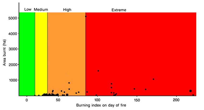
National Fire Danger Rating System                                                         July 2001

         recommendation is that the cut-off values can only be finalised after further work has been
         done on the range of indices likely to be experienced in South Africa, and once the model
         to underpin the South African NFDRS has been selected.

iii)     By comparing the forecast fire danger index values with the cut-off values, delineate areas
         where the forecast fire danger would be regarded as high.

iv)      Define areas of forecast high fire danger within municipal boundaries. Any municipality
         that has high fire danger forecast would then be subject to any restrictions and other
         measures in terms of the Act. An entire municipality will be subject to the prescribed
         actions for high fire danger even if only part of that municipality has a forecast high fire
         danger. This will be done to err on the side of caution.

This process therefore proposes that the most appropriate ‘regions’ that can be considered ‘usually
sufficiently uniform to allow for a single rating which is meaningful for the entire region’ would be
single municipalities. On a given day, several of these may simultaneously have a high fire
danger, but as the weather changes, the aggregation of municipalities rated as high would change
too.

Any municipality that had high fire danger rating forecast would then be subject to any restrictions
and other measures in terms of the Act.

CATEGORIES OF FIRE DANGER RATING AND THEIR USE

The most commonly used method of depicting the fire danger rating (FDR) is through the use of
colour codes. The ratings have been grouped into five categories, each represented by a colour
[Blue (insignificant), Green (low), Yellow (moderate), Orange (high) and Red (extremely high)]. We
provide examples of the expected fire behaviour for each category, and the measures that would
be needed to ensure fire suppression in each category. These descriptions are provided merely to
assist in developing an understanding of each rating and will need further refinement, in
consultation with stakeholders and experts, before being incorporated into the final NFDRS. The
‘recommended actions’ which should be taken when the FDR is a certain ‘colour’ could be
incorporated into regulations in terms of the Act, but are regarded as guidelines rather than
regulated activities. However, for each category there is also a list of actions that should be
mandatory and those which should be prohibited under certain fire danger conditions. It is these
actions that should be included into the regulations of the Act to ensure legal accountability for
certain actions when the fire danger is predicted to be ‘high’. These, too, are provided as
examples in this report, but will require further refinement and consultation before being
incorporated into legislation.

COMMUNICATION OF THE NFDRS

The Act specifies that the Minister must communicate the FDR to the Fire Protection Associations
(FPAs) regularly and, more specifically, when the danger is high, publish warnings to that effect.
Because the SAWB already has the means of disseminating the daily weather conditions to the
media, the communication of the fire danger ratings could be carried out by that institution, but this
would have to be negotiated with DWAF (which has the legal responsibility to do this).

Compliance by the public to the FDRs (e.g. total fire ban) will probably be difficult to enforce.
However, if the public becomes aware of the NFDRS, and perceives its purpose and its benefits in
a positive way, voluntary adherence to the conditions could reduce the incidence of fires. For this
reason, part of the communication strategy should address the awareness-raising aspect of the
NFDRS. The communication strategy should, therefore, extend beyond the communication of the
rating and also consider aspects such as awareness and training. Several mechanisms to

                                                  v
National Fire Danger Rating System July 2001
implement this are suggested, including modules in school curricula and a national ‘Fire
Awareness Day’. Advanced training at tertiary institutions is also suggested for land managers.
ADMINISTRATION OF THE NFDRS
There are a number of organizations that would be involved in the implementation of a NFDRS.
These include the SAWB, the FPAs and the National Disaster Management Centre (NDMC). Other
organizations that would be involved would be the electronic broadcasting media and the press.
The Department of Water Affairs and Forestry (DWAF) will carry overall responsibility for ensuring
that the Act is implemented at a national level while the SAWB will carry out the daily calculation of
fire danger indices and forecasts.
Fire Protection Agencies will be established in terms of the Act, and will have responsibility for co-
ordinating activities relating to the prevention and combating of fires in their areas of jurisdiction.
The NDMC should function as a repository and conduit of information pertaining to disaster
management. Municipalities could be approached to fulfil the functions of FPAs, until such time as
FPAs are established. It is also probable that FPAs will never be established in some areas (for
example semi-desert or desert areas where fires hardly ever occur). In such cases, DWAF may
legitimately decide that the relevant municipality need not participate in the NFDRS.
In terms of the Act, the communication of predicted high fire danger, through broadcasts and
publication in newspapers, is compulsory.
PROPOSED AMMENDMENTS TO THE ACT
An amendment to the Act, which may increase its effectiveness, concerns the delegation of
responsibilities to municipalities where FPAs do not exist. Regulations should be drawn up to
prescribe the format in which to report fire statistics as well as to ensure that fire danger rating
criteria are taken into account when permits are issued for burning (e.g. by Agriculture). Certain
activities which are prohibited or mandatory when the fire danger is high, will also need to be
included in the regulations.
viNational Fire Danger Rating System July 2001
A Description of the five proposed fire danger rating categories (Blue to Red), and examples of the fire behaviour, recommended control
measures, actions and restrictions for each.
BLUE GREEN YELLOW ORANGE RED
FDR Insignificant Low Moderate High Extremely high
RATING
FIRE Fires are not likely Fires will start but Fires fairly readily Fires readily ignited Any ignition source
BEHAVIOUR to start. If they will spread slowly. ignited and spread and spread unaided, likely to initiate a fire.
start, they are likely Flame lengths unaided, burning in with local crowning Fires will spread in the
to go out without typically < 1 m, the surface layers and short-range crowns of trees as
aid from and spread rates below trees. Flame spotting. Flame well as in surface
suppression forces. < 5 m/minute. lengths between 1 lengths between 2 layers, and long-range
There is little and 2 m, and spread and 5 m, and spread spotting will occur.
flaming rates between 5 and rates between 25 Spread rates can
combustion. Flame 25 m/minute, and 35 m/minute. exceed 60 m/minute
lengths < 0.5 m depending on fuel Spotting occurs, and flame lengths will
and spread rates type. increasing the rate of be in the order of 5 –
< 2 m/minute. spread. 15 m or more. Wide-
spread spotting,
greatly increases the
rate of spread.
FIRE No control Fires can be Fires not readily Fires cannot be Any form of fire
CONTROL necessary. approached on approachable on foot approached at all. control not likely to be
foot. Suppression for more than very Backburning, effective until weather
is readily short periods. Best combined with aerial changes. Backburning
achieved by direct forms of control water-bombing are dangerous and best
manual attack should combine the only effective avoided.
methods. water tankers and ways to combat fires.
backfiring from Equipment such as
prepared lines. water tankers should
concentrate efforts
on the protection of
houses.
viiNational Fire Danger Rating System July 2001
BLUE GREEN YELLOW ORANGE RED
RECOMMENDED None None, other than Open-air fires should All efforts should be Dangerous areas to
ACTIONS prudent care to only be permitted in made to bring any be evacuated.
ensure that any authorised fireplaces. fires under control.
open-air fires do Equipment such as
not escape. Prescribed burning Areas should be put water tankers should
should be conducted on standby for concentrate efforts on
Prescribed with care, and any evacuation should the protection of
burning prescribed fires the fire danger houses and other
permissible. should be conditions be structures.
extinguished should forecast to become
the forecast fire worse.
danger rating turn to
high.
PRESCRIBED None None Any unplanned fires No outdoor fires No outdoor fires
ACTIONS AND should be permitted. permitted.
RESTRICTIONS extinguished.
viiiNational Fire Danger Rating System July 2001
MONITORING AND EVALUATING THE NFDRS
Fire danger indices need to be interpreted in terms of the risk of fires occurring, the number and
size of fires that could be expected under certain conditions, their relative ease or difficulty of
control, and the damage they could be expected to do. The fire danger indices that are recorded in
any particular region could be related to the historic occurrence of fires, provided that such data
are available. At present, information on fires is not recorded in most areas in South Africa, and
where data are recorded, they are scattered and not in a suitable format for relating to fire danger
indices.
Basic data of the type outlined above should be collected by FPAs. Data on the occurrence, size,
severity, and duration of fires could be archived without mapping the fires. On the other hand, fires
could be mapped and captured on a geographical information system for archival. The choice of
approach will have significant implications for data collection and management, and needs to be
considered carefully.
The Department for International Development (DFID) has funded a project linked to this one, in
which the NFDR Information System is addressed in greater detail.
We have suggested that the responsibilities for calculating fire danger, curating the database, and
collecting fire statistics will be shared between DWAF, the FPAs, the SAWB and (potentially) the
NDMC.
CONCLUSION
This report has not addressed the implementation of the NFDRS, which was beyond our terms of
reference. The implementation of the NFDRS will be a complex process, requiring substantial time
and additional capacity from many different institutions in order for it to function effectively. Should
the recommendations in this report be adopted, DWAF will have to address implementation
through the development of a comprehensive business plan, particularly addressing the delegation
of DWAF’s responsibilities to the SAWB, FPAs and NDMC.
ixNational Fire Danger Rating System July 2001
TABLE OF CONTENTS
1. INTRODUCTION ....................................................................................................................... 1
2. THE PROCESS TO DEVELOP THE NFDRS ........................................................................... 2
3. OVERVIEW OF FIRE DANGER RATING SYSTEMS USED LOCALLY AND
INTERNATIONALLY................................................................................................................. 3
3.1 Swedish Angstrom Index ................................................................................................ 4
3.2 USSR Ignition Index........................................................................................................ 4
3.3 French Fire Danger Rating ............................................................................................. 4
3.4 Canadian Forest Fire Danger Rating System ................................................................. 5
3.5 US National Fire Danger Rating System ........................................................................ 6
3.6 McArthur’s Forest Fire Danger Index.............................................................................. 7
3.7 McArthur’s Grassland Fire Danger Index........................................................................ 8
3.8 The Lowveld Fire Danger System................................................................................. 10
3.9 Summary....................................................................................................................... 10
4. NATURE OF SOUTH AFRICAN CONDITIONS AND USERS............................................ 12
4.1 The biophysical conditions of South Africa ................................................................... 12
4.2 South African Users of Fire Danger Rating.................................................................. 15
5. AN OVERVIEW OF THE SOUTH AFRICAN CLIMATIC CONDITIONS AND CURRENTLY
AVAILABLE WEATHER DATA .............................................................................................. 17
5.1 Introduction ................................................................................................................... 17
5.2 Climatic Regions ........................................................................................................... 17
5.3 New climate regions...................................................................................................... 19
5.4 Forecasting weather and fire danger ............................................................................ 20
6. EVALUATION OF THE AVAILABLE MODELS ..................................................................... 20
6.1 Development of criteria to evaluate the models............................................................ 20
6.2 Application of the criteria for the selection of a suitable system ................................... 22
6.3 Conclusions .................................................................................................................. 24
7. HOMOGENOUS FIRE DANGER REGIONS........................................................................... 26
7.1 Introduction ................................................................................................................... 26
7.2 The process to determine uniform fire regions for South Africa.................................... 27
8. CATEGORIES OF FIRE DANGER RATING AND THEIR USE ............................................. 33
9. COMMUNICATION STRATEGY............................................................................................. 36
9.1 Communicating the FDR............................................................................................... 36
9.2 Awareness raising......................................................................................................... 36
9.3 Training ......................................................................................................................... 37
10. THE ADMINISTRATION OF THE NFDRS .......................................................................... 37
10.1 Duties, authorities and responsibilities ...................................................................... 37
10.2 Necessary amendments to the Act ........................................................................... 40
11. PROPOSED SYSTEM TO EVALUATE THE PERFORMANCE OF THE MODEL ............. 40
11.1 Data requirements..................................................................................................... 40
11.2 Approach for collecting data...................................................................................... 42
11.3 Approach for analysis and interpretation of data ....................................................... 42
11.4 Approach for feedback loops and improvement ........................................................ 43
xNational Fire Danger Rating System July 2001
12. CONCLUSION ..................................................................................................................... 45
13. REFERENCES..................................................................................................................... 46
List of Appendices
APPENDIX 1: Participants of the NFDRS workshop held at Kwalata Game Ranch on 8 & 9
June 2000.......................................................................................................... 49
APPENDIX 2: Comments report............................................................................................... 50
APPENDIX 3.1: McArthur’s Forest Fire Danger Index Equations ............................................... 74
APPENDIX 3.2: Calculating the Keetch–Byram Drought Index................................................... 75
APPENDIX 3.3: Drought Factor (Improved formula by Griffiths) ................................................. 76
List of Figures
Figure 3.1a Canadian Fire Weather Index and its component parts. . ........................................ 6
Figure 3.1b Canadian Forest Fire Danger Rating Model and its component parts....................... 6
Figure 3.2 Components of the US National Fire Danger Rating System. ................................... 7
Figure 3.3 McArthur’s Forest Fire Danger Index structure and inputs. ...................................... 9
Figure 3.4 McArthur’s Grassland Fire Danger Rating system (Mark IV)..................................... 9
Figure 3.5 The Lowveld Burning Index look-up table. .............................................................. 11
Figure 7.1 Map of South Africa depicting hypothetical isolines demarcating different fire danger
indices. .................................................................................................................... 29
Figure 7.2 Map of South Africa’s climatic regions, as developed by the SAWB, depicting FDIs
above which the fire danger would be considered to be high in the region
concerned. . ............................................................................................................. 30
Figure 7.3 By comparing the daily predicted fire danger indices (Fig. 7.1) with cut-off values for
different parts of the country (Fig. 7.2), areas of high fire danger are identified (in red
on the map).............................................................................................................. 31
Figure 7.4 The areas of high fire danger on any given day are overlaid with municipal
boundaries (categories A, B, C and D) to ensure clear demarcation of areas where
total fire bans will be prescribed. ............................................................................ 32
Figure 10.1 The proposed relationships between participating organisations with respect to the
collection of data, the calculation of fire danger indices, and the curation of
databases. ............................................................................................................... 38
Figure 11.1 Examples of the relationship between the highest burning index and the size of fires,
used to determine the cut-off points between different categories of fire danger . .. 44
List of Tables
Table 3.1 The table of rainfall correction factors (RCF) used to adjust the burning Index for
antecedent moisture conditions. ................................................................................ 11
Table 3.2 Comparison between the three main Fire Danger Rating models used internationally.
.................................................................................................................................. 12
Table 5.1 Average rainfall per season in millimetres (percentage of annual in parenthesis) for
two sites in each region.............................................................................................. 19
xiNational Fire Danger Rating System July 2001
Table 6.1 Comparison of eight Fire Danger Rating Systems with regard to meeting the criterion
of being able to able to predict and rate fire danger both reliably and consistently. .. 25
Table 6.2 Comparison of eight Fire Danger Rating Systems with regard to meeting a range of
criteria. ....................................................................................................................... 26
Table 8.1 A description of the five proposed fire danger rating categories (Blue to Red), and
examples of the fire behaviour, recommended control measures, actions and
restrictions for each.................................................................................................... 34
Table 11.1 Typical questions asked by fire managers, the nature of answers required, and the
data needed to support the answers.......................................................................... 41
xiiNational Fire Danger Rating System July 2001
NATIONAL FIRE DANGER RATING SYSTEM
1. INTRODUCTION
During 1998, South Africa passed a new National Veld and Forest Fire Act (Act 101 of 1998),
hereafter refered to as ‘the Act’. The Act provides for the prevention of veld, forest and mountain
fires through the deployment of a National Fire Danger Rating System (NFDRS) (Section 3 of the
Act). Such a system does not exist at a national level at this stage, although localised fire danger
rating systems are used in some regions such as the KwaZulu-Natal Midlands, Mpumalanga and
the Western Cape.
A NFDRS will allow for the prediction of potentially hazardous conditions conducive to large and
potentially damaging wild fires. This will allow for preventative measures to be taken to both reduce
the risk of unwanted ignitions, and to increase the state of readiness for dealing with wild fires.
The NFDRS should also be regarded as one of the early warning systems required by the National
Disaster Management System (NDMS).
There are several international fire danger rating systems as well as a locally developed system,
from which to choose. Fire is a physical process that behaves according to physical principles
wherever it occurs. This suggests that models developed elsewhere should work equally well in
South Africa, providing that good weather data are available for running the model(s) that underpin
the systems.
The terms of reference for the development of a NFDRS for South Africa (developed by the ‘Veld
and Forest Fire Committee’ of DWAF) state that: ‘The system that is developed for South Africa
needs to be simple, but effective. It should be able to produce relevant indices of fire danger from
easily measured or predicted environmental parameters, and it must be able to relate these to the
risk of fire occurrence (the number of fires that could be expected to occur in a given region), the
potential severity of fires (the potential intensity with which they will burn, and the level of damage
they are likely to cause), and the potential size of fires (the likely area that will burn under the given
conditions).’
In response to this requirement for a national system, the Department of Water Affairs and Forestry
(DWAF) contracted the CSIR to develop a NFDRS for South Africa. This report provides an
account of the process followed in the selection of an appropriate NFDRS for South Africa and
provides an overview of the main components of such a NFDRS.
The tasks which the CSIR undertook in the development of the NFDRS can be summarised from
our terms of reference as follows:
Task 1 Develop a fire danger rating system and, in so doing, assess the need for additional
authority, duty or responsibility in terms of the Act.
Task 2 Develop proposals for the subdivision of the country into regions which are relatively
uniform within their boundaries with regard to the fire danger that would prevail for
any period of time (Section 9(3) of the Act).
Task 3 Provide recommendations for the best means of communicating the ratings
generated by the use of the system to and within each region as required by Section
10(1) of the Act.
Task 4 Develop a proposal (mechanisms) for a cost effective system to evaluate the
performance of the NFDRS2.
2 This TOR is now addressed by a separate project.
1National Fire Danger Rating System July 2001
The overall assignment was to be conducted with regard to:
a) the need to comply with the Act as a minimum in all cases;
b) the need for practicality and effectiveness in developing a system for rapid deployment;
c) the need for due and appropriate consultation with relevant stakeholders; and
d) regular communication and liaison with the commissioning Department (i.e. DWAF).
2. THE PROCESS TO DEVELOP THE NFDRS
The proposed NFDRS for South Africa was developed by a team of experts, in consultation with
the Veld and Forest Fire Committee of DWAF and several key stakeholders.
While it was beyond the scope of this project to engage in a thorough consultation process with all
interested and affected parties in terms of fire danger prediction, there were certain major role-
players and users who needed to be informed of the process and who needed to contribute to the
understanding of the NFDRS. These key stakeholders, identified as essential contributors to this
process, are listed below, but informal discussions with various other interested parties took place
throughout the duration of the project. The key stakeholders were:
• Department of Water Affairs and Forestry (DWAF) (Veld and Forest Fire Committee)
• South African National Parks (SANP)
• Provincial Parks Boards or Departments of Conservation/Environment (all nine provinces)
• National Department of Agriculture (and Agricultural Unions)
• Department of Provincial and Local Government
• Existing Forest Fire Associations (and Fire Control Committees)
• South African Weather Bureau (SAWB)
• Forest Owners Association (FOA)
• South African Timber Growers’ Association (SATGA)
• South African Wattle Growers’ Association (SAWGA)
• South African Emergency Services Institute
The process undertaken to select the NFDRS can be summarised as follows:
1. A working meeting to prepare a first draft of the proposed FDRS was held at the CSIR on 28
and 29 February 2000. The proceedings of the meeting and the documentation generated
from it were distributed to the key stakeholders for comment in May 2000.
2. A workshop was held at Kwalata Game Ranch on 8 and 9 June 2000 to which all the key
stakeholders were invited. A list of delegates who attended the workshop is attached
(Appendix 1). On the first day of the workshop, the proposed outputs from the first meeting
were presented and reviewed (including the preliminary criteria for evaluating the models
and the choice of model for South Africa). Other aspects of the NFDRS (such as the
delineation of zones, the format for presenting the fire danger rating, the activities
associated with each rating and the communication strategy) were developed and refined
on the second day.
3. A report based on the outputs of the Kwalata Workshop was submitted as a first draft to all
key stakeholders for comment at the end of July 2000. Comments received have been
incorporated into this report, wherever possible. All comments received are attached in
Appendix 23. This appendix also contains a summary of the major issues raised by the
stakeholders and a brief description of how these issues have been addressed.
3 It is important to note that references to page numbers, paragraphs, etc in the comments refer to earlier
drafts and are therefore not consistent to the content of this report.
2National Fire Danger Rating System July 2001
4. A draft final report was submitted to DWAF for review. Subsequent meetings with the Veld
and Forest Fire Committee have been held to decide on actions still required. This report
incorporates the issues and concerns from DWAF and inputs from the other institutions. As
part of the process to incorporate the Client’s concerns, further consultation was held with
representatives of the SAWB, Cape Nature Conservation, SA National Parks and SAFCOL
before re-submission of the report.
3. OVERVIEW OF FIRE DANGER RATING SYSTEMS USED LOCALLY AND
INTERNATIONALLY
A fire danger rating system, as required in the Act, will have the primary purpose of preventing and
controlling wild fires. This prevention should come about through the ability to identify the
conditions that would lead to dangerous fires, and then through the effective prevention of activities
that would lead to the ignition of fires under such conditions. The system should consist of the
following elements:
i) The capacity to monitor, on a continuous basis, the conditions that would affect fire
danger (s 9(1));
ii) The ability to delimit the regions that would be affected by high fire danger conditions (s 9
(3));
iii) The ability to take relevant factors into account, using appropriate formulae (s 9 (4) (a)
and (b)). This will often require the use of models which simulate the ease of ignition and
potential fire behaviour;
iv) The ability to identify high fire danger, and the listing of precautions that should be taken
when the fire danger is predicted to be high (s 9 (4) (d)); and
v) The ability to communicate the fire danger ratings and necessary precautions effectively
(s 10 (1) and (2)).
Fire danger is the result of both relatively constant (fuel, topography) and variable (weather) factors
affecting the inception, spread, difficulty of control and potential to do damage (Chandler et al.
1983). A fire danger rating system uses models which simulate those factors that combine to
affect fire danger, usually producing one or more indices of fire danger. It also normally ranks
these into discrete classes for the purpose of conveying public warning, implementing mitigation
measures and for setting an appropriate level of readiness for suppression resources.
Many fire danger rating models only use weather elements in the calculation of the index and
assume that the fuel, topography and ignition elements are kept constant. In this way it is possible
to use weather forecasts to predict the fire danger for a period of time ahead. The weather inputs
are usually taken from a specific weather station which is broadly representative, and then applied
to the surrounding region.
There are several models in use that can be used to support a fire danger rating system. It is
important not to confuse fire danger with fire behaviour, which describes the manner in which
fuel ignites, flame develops and fire spreads. In fire behaviour prediction the important outputs are
rate of spread, flame height, fire intensity and the spotting potential. Fire danger rating, on
the other hand, produces a rating of the risk of a fire occurring, and of doing damage. Fire
behaviour prediction is used at a finer scale than fire danger rating – for example, for predicting the
behaviour of a fire in a particular field as opposed to estimating the risk of fire over a whole region
or province. For this reason the fire behaviour research already carried out in South Africa
(Everson et al. 1985; van Wilgen, Le Maitre and Kruger 1985; van Wilgen and Wills 1988; Trollope
1998) cannot be used for improving or testing fire danger rating models. In this section the
different models are reviewed in relation to their ability to predict fire danger.
3National Fire Danger Rating System July 2001
3.1 Swedish Angstrom Index
The simplest fire danger rating model is the Swedish index called the Angstrom Index. The
Angstrom Index uses only temperature and relative humidity in its calculation and provides an
indication of the likely number of fires on any given day. The Angstrom Index is calculated
according to formula (1).
⎛ R ⎞ ⎡ (27 − T )⎤
I =⎜ ⎟+⎢
⎝ 20 ⎠ ⎣ 10 ⎥⎦ ………………(1)
where: I = Angstrom Index
R = Relative humidity (%)
T = Air Temperature (oC)
Interpretation:
> 4.0 Fire occurrence unlikely
4.0 – 2.5 Fire conditions unfavourable
2.5 – 2.0 Fire conditions favourable
< 2.0 Fire occurrence very likely
The Angstrom Index is useful only as an indication of the dryness of the air. It does not cater for
fuel moisture status or the important role that wind plays, as it ignores both rainfall and wind.
3.2 USSR Ignition Index
The USSR Ignition Index, developed in Russia, has a similar basis to the Angstrom Index. This
index also uses temperature and relative humidity, but adds the effect of recent rainfall on the fine
fuel flammability. The USSR Ignition Index recognises that if more than 3 mm of rain falls, then
there will be a period of time when the fuel will not burn, so the index returns to zero. This index
estimates the dryness of the fine fuel, assuming that the drying rate is related to the vapour
pressure deficit and the length of the period of drying. The calculation of this index is according to
formula (2).
W
P = ∑ (ti − Di ) ∗ ti ………………(2)
i =1
Where: P = Ignition index
W = number of days since last rainfall > 3mm
t = temperature (oC)
D = dew point temperature (oC)
Interpretation:
0 – 300 Nil Fire Danger
301 – 1000 Moderate Fire Danger
1001 – 4000 High Fire Danger
> 4000 Extreme Fire Danger
3.3 French Fire Danger Rating
A fire danger index used in France combines the effects of a ‘drought index’ with wind speed as a
measure of fire danger. Seasonal dryness is calculated by estimating the soil moisture capacity
and adding to or subtracting from it according to the daily evapotranspiration balance. Potential
evapotranspiration is calculated using a formula that includes daily rainfall, temperature and
relative humidity. The effect of daily evapotranspiration for a given soil dryness provides the basis
of this index of fuel dryness – a drought index (formula 3). The drought index provides a measure
4National Fire Danger Rating System July 2001
of ease of ignition as well as fuel availability. When this drought index is combined with wind
speed, the potential rate of fire spread is also included. Thus, the fire danger index gives both a
measure of ease of ignition as well as potential spread rates.
D =Ce
(−∑ E C )
…………………(3)
where: D = Drought index
C = Available water capacity in the soil (mm)
E = Potential evapotranspiration (Thornthwaite, 1948)
Fire Danger = Drought Index + Windspeed
3.4 Canadian Forest Fire Danger Rating System
The model in the Canadian Forest Fire Danger Rating System (CFFDRS) has evolved and
developed since the mid-1920s. The basis of this system has been extensive field experimentation
and observation of fire behaviour. A wide range of vegetation types have been studied, but the
most common forest types studied have been the Jack Pine and Lodgepole Pine forest which are
widespread in Canada. These forests have been used as the standard fuel type in the calculation
of the Fire Weather Index (FWI) and its component indices. The FWI was introduced in 1969 and
is now applied nationally in Canada. The Canadian FFDRS model has been tested or adapted in
New Zealand, Fiji, Alaska, Venezuela, Mexico, Chile, Argentina and Europe. The Fire Weather
Index requires only daily temperature, relative humidity, rainfall, and wind speed inputs for its
calculation. This is one of this system’s desirable traits.
For a long time, the Canadian FFDRS has used only the FWI and its component parts as the basis
for fire management. The FWI provides an indication of the ease of ignition, and should fires start,
the potential spread and relative intensity of fires (Figure 3.1a). In recent years, this system has
been developed further to incorporate the likely number of ignition sources and the potential fire
behaviour in different fuel types, which offer a more comprehensive and specific fire danger rating
system for different areas in Canada (Figure 3.1b). The advancement of the fire danger rating
system beyond the Fire Weather Index has taken considerable research effort and has customised
the system for application in different regions of Canada. To determine the influence of these
additional factors, human and lightning ignition risks are essential inputs to the model, along with
the character of the regional fuel and topography. The fire occurrence potential (FOP) and fire
behaviour potential (FBP) components have made the system less transferable to other vegetation
types, but the FWI is still broadly applicable to areas outside Canada.
5National Fire Danger Rating System July 2001
Risk Weather Topography Fuels
(lightning and human)
FWI
System
Accessory
FOP FBP
System Fuel Moisture System
System
CFFDRS
Figure 3.1a Canadian Fire Weather Index and its component parts. The terms are: FOP
(Fire Occurrence Potential), FWI (Fire Weather Index), FBP (Fire behaviour
prediction) and CFFDRS (Canadian Forest Fire Danger Rating System).
Observations Temperature Wind Speed Temperature Temperature
Relative Humidity Relative Humidity Rainfall
Wind Speed Rainfall
Rainfall
Fuel
Fine Fuel Duff Moisture Drought
Moisture
Codes
Moisture Code Code Code
(FFMC) (DMC) (DC)
Initial Spread Build Up
Fire
Behaviour Index Index
Indexes (ISI) (BUI)
Fire Weather
Index
(FWI)
Figure 3.1b Canadian Forest Fire Danger Rating Model and its component parts.
3.5 US National Fire Danger Rating System
The simulations of fire danger in the United States National Fire Danger Rating System (US
NFDRS) (Deeming et al. 1978) are based on Rothermel’s fire behaviour model (Rothermel 1972).
The US NFDRS was first introduced and applied nationally in the US in 1972. The model has
been tested in South Africa, Europe, Asia and Australia.
6National Fire Danger Rating System July 2001
The US NFDRS has been used across the United States and applied to a wide range of vegetation
(fuel) types and climatic conditions. The system is based on a physically based fire behaviour
model, which has the advantage of being based on fundamental processes. A disadvantage is the
necessary increased complexity introduced when parameterising the model for new situations.
An outline of the inputs and modules of the system is shown in Figure 3.2. Unlike the models
already discussed, the US NFDRS requires some data (rainfall duration and cloudiness) that are
not always readily available. It is also important to use the most appropriate fuel model (a set of
descriptors that characterise the dominant vegetation type in an area) to reflect the desired fire
danger conditions.
The fuel models cover a wide range of fuel types, and include live fuel moisture content.
Potentially, this could be very useful where canopy fuels are a significant part of the fine fuels such
as in shrublands or forests subject to crown fires. The outputs from the model include a spread
component (SC), an energy release component (ERC) and burning index (BI). More recent
development of the system has incorporated ignition components for both human-caused and
lightning-caused ignitions, so that the fire load or fire severity index can be estimated. The
system therefore produces six indices – spread, energy release, burning, human ignition, lightning
ignition and fire load indices.
Fuel Model Relative Humidity Max/Min RH Previous
Observations 100-h FMC
Slope Class Temperature Max/Min Temp
Herb fuel type Cloudiness Rainfall duration 1000-h FMC
Wind Speed Fuel Stick MC
Fuel Moisture 1-h FM 10-h FM 100-h FM 1000-h FM Live FM
Component
Energy Release
Fire Spread Component Burning Index
Component
Behaviour (SC) (BI)
(ERC)
Indexes
Ignition Component Fire Severity
Lightning & Human Index
Figure 3.2 Components of the US National Fire Danger Rating System.
3.6 McArthur’s Forest Fire Danger Index
Fire danger ratings were first used in Australia in 1936. Following the devastating wildfires in south-
eastern Australia in 1939, a new impetus was given to improve fire management. The McArthur
Forest Fire Danger Index was introduced in 1958 (McArthur 1958, 1960, 1962, 1966, 1967). This
model continued to be developed, and today the Mark IV version of the index is used in south-
eastern Australia. The Forest Fire Danger Index (FFDI) is subdivided into five classes rating the
difficulty of suppression (Low, Moderate, High, Very High and Extreme).
7National Fire Danger Rating System July 2001
The McArthur FFDI is based on an empirical model (Appendix 3.1) of fire behaviour in open
forests, but the fire danger index is applied broadly to all forest types, shrublands, heathlands and
mallee. Although the fire behaviour differs in these other vegetation types, most of the basic fire
danger factors are common. Adaptation to vegetation types other than open forest is by means of
redefining the different fire danger classes. A separate fire danger index system was developed
for grasslands which included a grass curing module in place of the fuel availability module of the
FFDI.
The structure of the McArthur FFDI is shown in Figure 3.3. Inputs required to run the model are air
temperature, relative humidity, wind speed, rainfall, time since last rainfall, and the Keetch-Byram
Drought Index (KBDI) (Keetch and Byram 1968). The KBDI itself requires the daily maximum
temperature, daily rainfall, the previous day’s KBDI and the average annual rainfall for the area
being considered (Appendix 3.2).
The magnitude of the index is directly proportional to the rate of spread of a fire burning in an open
eucalypt forest, on flat ground, and with an average surface fine fuel load of 12 t/ha. In vegetation
types other than open eucalypt forest, the relationship with rate of spread may vary. The index is
then subdivided into fire danger classes based on the difficulty of suppression, ranging from Low
(where there is a low difficulty of suppression) to Extreme (where fire suppression is extremely
difficult, if not impossible, due to the rate of spread and amount of spotting ahead of the fire front).
3.7 McArthur’s Grassland Fire Danger Index
McArthur’s Grassland FDI (McArthur 1960, 1966) has a similar basis to the FFDI, except that the
fine fuel availability calculated using the Drought Index and Drought Factor components
(Appendix 3.3) is now calculated using the degree of curing (Figure 3.4) (Griffiths 1999). Curing is
defined as the proportional weight of dead grass to live grass, so a curing factor of 80% means that
of the total grass biomass, 80% of the grass is dead. The moisture content of green grass is
affected by physiological processes and is generally above the moisture of extinction (i.e. it is too
wet to sustain combustion). However the dead grass moisture content is affected by local
atmospheric conditions such as air temperature and relative humidity. The fuel moisture content is
therefore determined by the combination of the degree of curing and the environmental conditions
affecting the dead fuel moisture content. The fine fuel moisture content combined with the wind
speed, are the main determinants of fire spread rate. The Grassland FDI is based on the predicted
spread rate of a fire in lightly grazed temperate perennial grassland on flat ground. Fire spread
rates would increase where the topography is generally hilly and where the grass is tall, and
decrease where grasslands are heavily grazed or recently burnt. A revision was made to the Mark
(Mk) IV version of the index which included a fuel loading component, but the performance of this
index is no better than the Mk IV, so little use is made of the Mk V version.
8National Fire Danger Rating System July 2001
FOREST FIRE DANGER INDEX
Suppression Difficulty
Rate of Spread Sub-model
Sub-model
Fuel moisture
Wind speed Wind speed
Fuel moisture Rate of spread
Fuel availability
Fine Fuel
Availability or Fuel Moisture
Drought factor Sub-model
sub-model
KBDI
Temperature
Relative Humidity
Days Since Rain
Rainfall
Max Temp
Rainfall
Annual Rainfall
Figure 3.3 McArthur’s Forest Fire Danger Index structure and inputs. KBDI is the Keech
Byram Drought Index.
Degree of Temperature
Observations Wind Speed
Curing Relative Humidity
Fuel Moisture
Component Fine Fuel MC
Fire Behaviour Rate of Spread
Component
Difficulty of
Fire Danger Index
Suppression
Figure 3.4 McArthur’s Grassland Fire Danger Rating system (Mark IV).
9National Fire Danger Rating System July 2001
3.8 The Lowveld Fire Danger System
The current fire danger rating model used in parts of South Africa is an adaptation of a Fire Hazard
Index developed by Michael Laing in Zimbabwe (then Rhodesia) in 1968 (Laing 1978). The basic
model uses the same inputs as the McArthur models, which are scaled to produce a simple model
that can calculate numbers easily without needing any complex calculations. (McArthur 1958,
1967). It is often referred to as the ‘Lowveld Fire Danger System’ since this is where it has been
most widely used. However, the process by which the system was developed, and the
assumptions that were made, were never documented (M. Laing, pers. comm.).
The calculation of the Burning index (BI) uses a simple nomogram (Figure 3.5) using temperature
and relative humidity or computer programs. Once the burning index has been obtained it is then
adjusted for wind by adding a value according to the prevailing wind conditions at 14h00. For
example, if the windspeed is between 3 and 8 km/h then a value of 5 is added to the burning index.
The fine fuel availability is accounted for by using a, ‘rainfall correction factor’ that uses the
antecedent rainfall conditions to adjust the burning index (Table 3.1).
A recent modification to the calculation of the Lowveld FDI has been to the Rainfall Correction
Factor. This adjustment applies if the temperature exceeds 23oC, the relative humidity is less than
50% and the wind speed is greater than 20 km/h. When this occurs, the latest rainfall event is
moved back one day for every hour these conditions persist. This adjustment recognises that fine
fuels will be drying quicker than usual under these conditions and hence the probability of fires
starting and the rate of fire spread, should one start, will be greater. Other recent adjustments to
make the model more suitable for local conditions include changes to make the temperature scale
more sensitive to higher temperatures, a smother wind correction factor and a forecasting model
using barometric pressure, historical data and weather forecasting information (Heine, pers.
comm.)4.
3.9 Summary
The three main Fire Danger Rating Systems used internationally are the US NFDRS, the Canadian
FFDRS and the McArthur FDIs. Some of the features of these systems are summarised and
compared in Table 3.2. The models vary in the degree of sophistication and requirement for data
input.
4 Mr Johan Heine, Forest Fire Association (Lowveld)
10You can also read