The Grand Canyon of the Colorado River - edited by David L. Alles Western Washington University e-mail
←
→
Page content transcription
If your browser does not render page correctly, please read the page content below
The Grand Canyon of the Colorado River

                       edited by
                    David L. Alles
           Western Washington University
             e-mail: alles@biol.wwu.edu

                Last updated 2012-6-29

Note: In PDF format most of the images in this web paper
           can be enlarged for greater detail.

                           1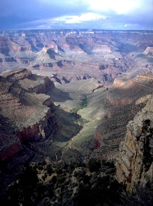
The Grand Canyon, one of the deepest canyons in the world with a depth of 1 mile
(1.6 km), can be seen in this spectacular photograph taken from the space shuttle. The
canyon is 280 miles (450 km) long and averages nearly 10 miles (16 km) in width. The
view is to the southwest with the snow-covered Kaibab Plateau in lower right portion of
the image and the Coconino Plateau in the upper left. The lower portion of Marble
Canyon (bottom center) ends where the Little Colorado River (lower left) joins the
Colorado River. This marks the point where the Grand Canyon turns west and begins
cutting through the Kaibab Plateau.

                     (Space Shuttle photograph courtesy of NASA)

                                           2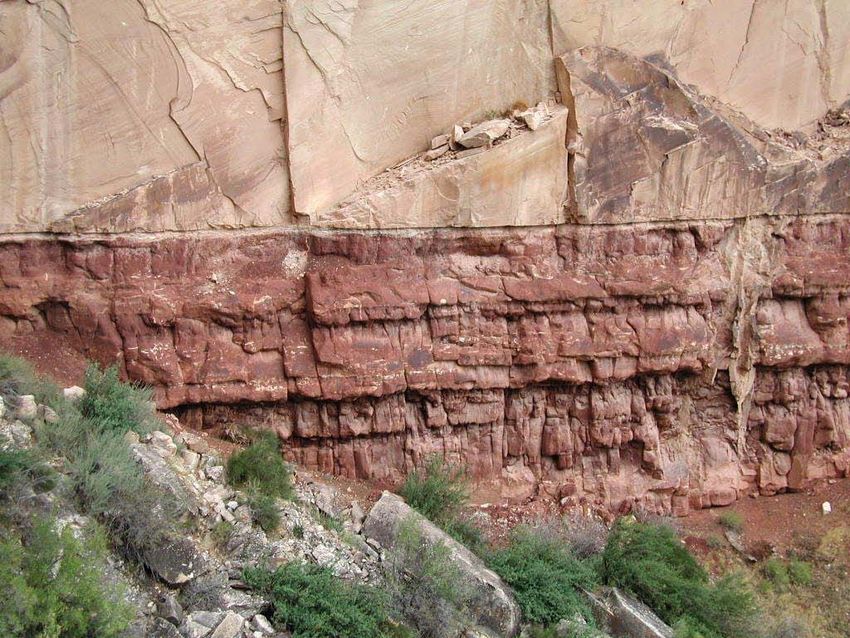
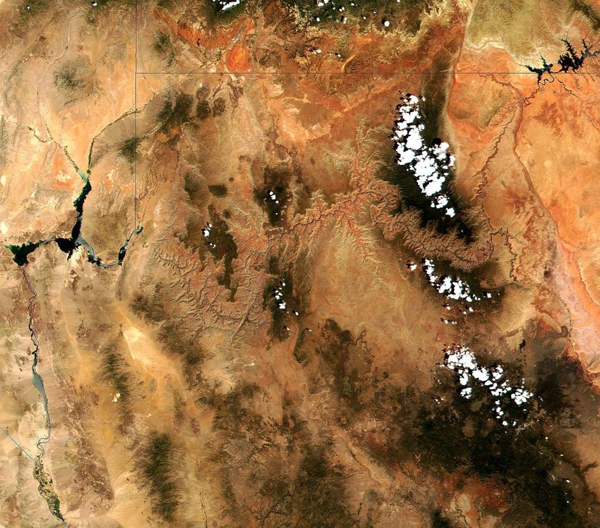
This satellite image shows the Colorado River from Lake Powell on the border of
Utah and Arizona (upper right) through the Grand Canyon to Lake Mead (center left) on
the border between Arizona and Nevada.

                          (MODIS image courtesy of NASA)

                       For area maps of the Grand Canyon go to:
                   http://www.nps.gov/grca/planyourvisit/maps.htm

                                           3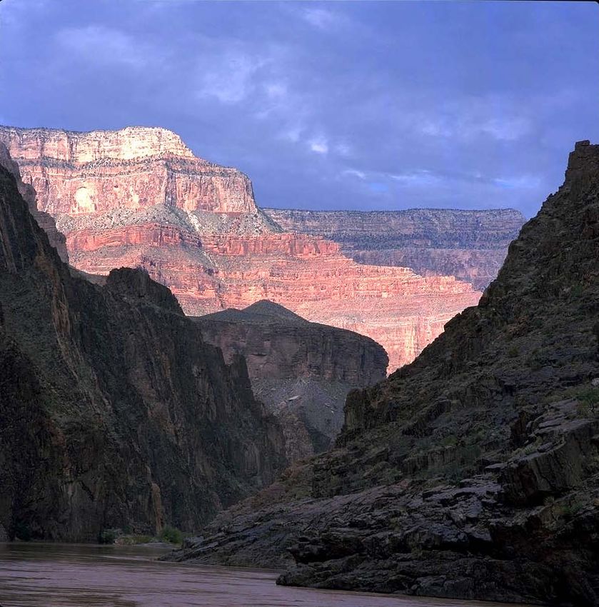
Relief Map of Arizona with the Grand Canyon in the Northwest Corner
                     (Map courtesy of USGS)

                                4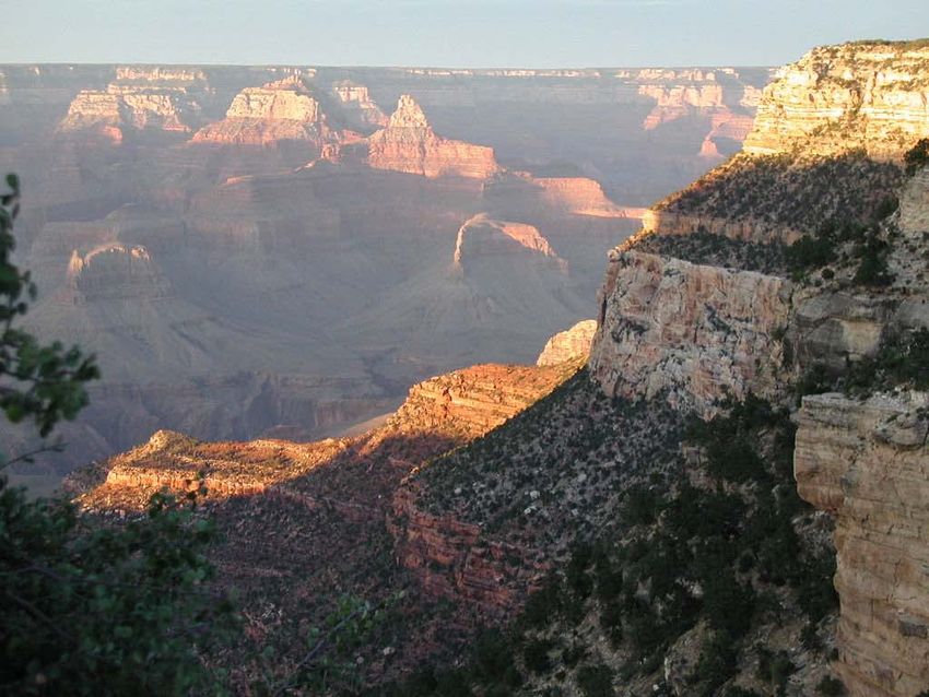
The Colorado River begins its 280 mile meandering journey through the Grand
Canyon at Lee’s Ferry (above), the zero point for measuring mileage downstream.

                                         5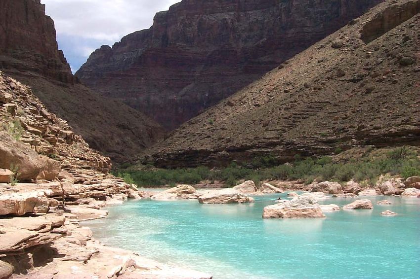
Downstream from Lee’s Ferry the river has cut the narrow, steep-walled Marble
Canyon. As shown above, its rock walls start rising sharply about 30 miles downstream.
Further downstream at the confluence of the Little Colorado, Marble Canyon gives way
to the deeper, broader Grand Canyon as the river turns sharply west. Although Marble
Canyon bears little resemblance to the expansive canyon downstream of it, it cuts through
the same rocks and is considered part of the same geological formation.

                             (Photograph by Bob Ribokas)

                                           6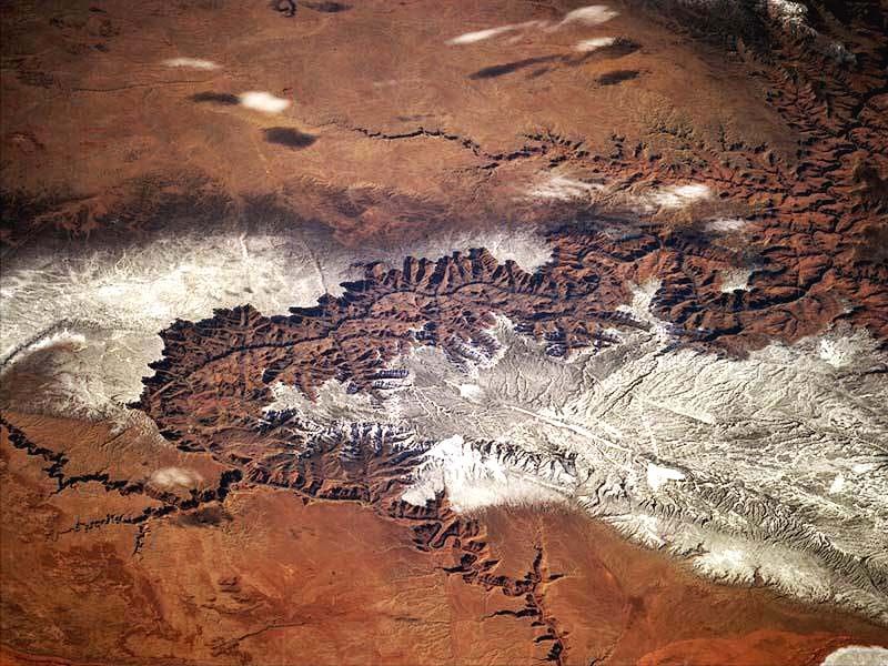
This picture of Marble Canyon looks upstream to the north. In the bottom left the
Little Colorado River can be seen entering the Colorado at mile 62. The waters of the
Little Colorado are usually turquoise but runoff from thunderstorms has turned them a
reddish brown.

                                            7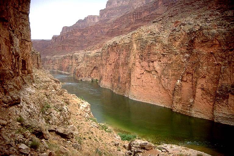
During the thunderstorm season the Little Colorado receives much of its flow from
upstream mesas and mountains that easily erode. By the time the Little Colorado arrives
at the Grand Canyon, it has the consistency and color of a thick chocolate milkshake.
When you see pictures of a muddy Colorado River in the Grand Canyon, it is often after
heavy summer thunderstorms when the Little Colorado is contributing a heavy load of
mud and silt. When the Little Colorado is not receiving water from the upper watershed
(as pictured above) the entire flow comes from the Sipapu, a travertine spring. The Hopi
Indians believe this is where man emerged from the earth after passing through a
succession of worlds. The water is crystal clear, extremely alkali, and warm (around 78 F
/14 C). The Little Colorado's bright turquoise color is the result of bleaching of bottom
sediments by the river's heavy mineral load.

      (Photograph by J.& D. Gould http://www.gouldhome.com/grand/index.html )
                                   Web Reference
                    http://www.cpluhna.nau.edu/Places/littlecolr.htm

                                           8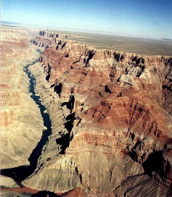
One of the most spectacular examples of erosion anywhere in the world, the Grand
Canyon is unmatched in the vistas it offers. Sunset at the Grand Canyon provided this
spectacular view from the Bright Angel trailhead looking northward from the south rim.
Bright Angel trail intersects the river near mile 88.

       The thick sequence of sedimentary rocks exposed in the walls of the canyon
provide a remarkable record of the Paleozoic Era (550-250 million years before the
present), but the canyon itself has been carved by erosion relatively recently, only during
the past five to six million years.

                                   Web Reference
                  http://www.durangobill.com/Paleorivers_preface.html

                                             9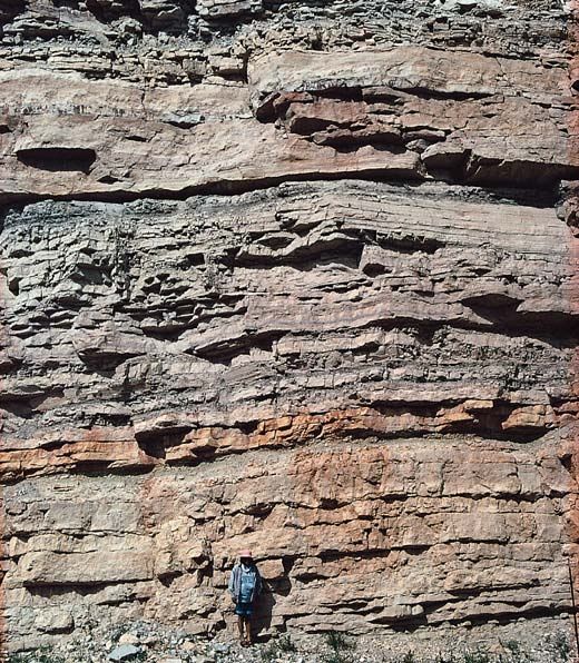
The View from Bright Angel Lodge on the South Rim
(Photograph by Philip Greenspun http://photo.net/philg/ )

                           10
Geologic Strata of the Grand Canyon
For more information on the geology of the Grand Canyon go to:
http://www.kaibab.org/geology/gc_geol.htm
and
http://www.classzone.com/books/earth_science/terc/content/investigations/es2906/es290
6page01.cfm
11The striking contrast between the light buff colored Coconino Sandstone and the
muddy red Hermit Shale is cause for this portrait of a rock wall along the Bright Angel
trail in the Grand Canyon. The easily eroded shale was deposited as mud in flood plains
and tidal flats, and owes its red color to iron oxides. Fossilized reptile tracks and plants
are found in the shale. The mud flats dried and cracked as they were overrun by
advancing sand dunes. The tilted bedding and uniform size and purity of the quartz grains
of the Coconino formation indicates deposition as wind-blown sand. Some of that sand
can be seen filling a deep crack in the underlying red shale (right center).
12Layers of sedimentary rocks in the Grand Canyon (shown above) are nearly a mile
(1.6 km) deep along the deepest portion of the canyon.
(Photograph courtesy of National Academy of Sciences)
13Shown rising from the water’s edge, Vishnu Schist forms the Precambrian
bedrock on which the Paleozoic sediments of the canyon lie.
(Photograph by Philip Greenspun)
14Vishnu Schist and the younger Zoroaster Granite that intrudes it, as shown in this
image, are some of the oldest rocks known, with respective ages of 2,000 million and
1,700 million years old.
(Photograph by Mark Meyer http://www.photo-mark.com/ )
15The ancient Vishnu Schist forms the inner gorge of the canyon from mile 77, as
you enter Upper Granite Gorge (shown above), to mile 130 at Granite Narrows.
(Photograph by Bob Ribokas)
16William Bell of the Wheeler survey of 1872, took this photograph of the Colorado
River looking downstream from the mouth of Kanab Creek (mile 143). Downstream from
this point for almost 25 miles the river is confined to a narrow inner gorge with near
vertical sidewalls of Redwall and Muav Limestone. Notice how the debris fan (lower
foreground) from Kanab Creek (right edge center) has a scoured appearance and little
vegetation.
(Photograph courtesy of George Eastman House Still Photograph Archive
http://www.geh.org/ne/mismi2/williambell_sum00001.html#79:0014:0017 )
17This picture was taken just above Kanab Rapids in 1997. The rapids are formed by
debris washed out by Kanab Creek. High water has almost covered the debris fan where
Bell took his picture of the river in 1872. Just the upper portion of the fan can be seen
lower right of center.
(Photograph by Bob Ribokas)
18At the Toroweap overlook (mile 176) on the north rim of canyon in the Tuweep
area you can stand on the edge of a red sandstone cliff and look straight down 3,000 feet
to the Colorado River below. Toroweap Point’s first recorded non-Indian visitor was
John Wesley Powell in 1870, on his futile search for the three lost members of his 1869
Colorado River expedition.
William Bell took the first pictures of the Grand Canyon from the Toroweap
overlook. Above is Bell’s picture looking upstream from the point, showing the Grand
Canyon below Cove Canyon as it was in 1872. The high point in the distance is called
Big Point.
(Photograph courtesy of George Eastman House Still Photograph Archive)
19Again looking upstream from Toroweap Point, this picture shows the
Grand Canyon below Cove Canyon as it is today.
(Photograph courtesy of John Crossley)
Web Reference http://www.durangobill.com/GCTour172.html
20Before 1963, melting snow in the upper Colorado River basin produced high flows
that raced through the Grand Canyon each spring. An average peak discharge of 93,400
cubic feet per second scoured large volumes of sediment from the river bottom. Later in
the summer, receding floodwaters deposited this scoured sediment and also sediment
carried in from tributaries. This annual scour and fill process maintained large sand bars
along the river banks, kept sand bars clear of vegetation, and kept debris fans—deposits
of cobbles and boulders that form at the mouths of tributaries—from constricting the
river. Reduced frequency of flooding since the completion of the Glen Canyon Dam has
reduced the size of sand bars and allowed vegetation to encroach on the channel, debris
fans to build up, and backwater areas used by native fish to fill in. In the 1872 Bell
picture from Toroweap Point, note the extensive sand bars stretching along the river. In
the recent Crossley picture above, the sand bars along the same stretch of river are
drastically reduced.
"In 1996, after years of debate, scientists at the US Geological Survey agreed on a
plan to restore the ecosystem. They hoped that releasing a massive flood through the dam
would shift sediment trapped at the bottom of the river and rebuild the beaches. Later that
year, they pumped an extra 1,290 cubic metres of
water per second down the canyon for a week, at an estimated cost to power companies
of $2.5 million. It was a failure—there just was not enough sediment in the river to
redistribute.
In 2004 they tried again, timing the flood to coincide with an annual release of
sediment from the Paria River, just downstream of the Glen Canyon Dam. But despite
high hopes, this failed too. The results directly contradict rosy predictions made in 1996,
says the scientists’ report, which concludes that the only way to rebuild the sandbars
permanently is with a continuous source of new sediment.
'Full restoration of the river is impossible,' says John Schmidt, a geomorphologist
at Utah State University in Logan, who helped to plan the 1996 and 2004 floods. 'It is a
much more difficult challenge than anticipated.' He says it’s time for Americans to
realize that they cannot have a huge power-generating dam and a natural river
ecosystem."
Dalton, R. (2005). Floods fail to save canyon beaches. Nature, 438(Nov 3), 10.
21Shown above is the bottom of the canyon as it is today below Toroweap Point just
above Lava Falls at mile 179. Again, note the lack of sand bars and the vegetation that
has built up along the river’s edge.
(Photograph courtesy of John Crossley)
22The canyon begins to open up at mile 191 along the last stretch of the river before
Lake Mead. If you compare this portion of the Grand Canyon with almost any other
canyon, it is still very impressive. But if you compare it with portions of the Grand
Canyon upstream, it is dull by comparison. The generic limestone cliffs bordering the
river still rise 2,500 feet from the river’s edge, but they are not as sheer as those in the
upper canyon.
(Photograph by Bob Ribokas)
23Sunset over Lake Mead near Pearce Ferry
Pearce Ferry marks the traditional boundary between Lake Mead and the Grand
Canyon. Here the low sandy banks around the lake give way to the cliffs that enclose the
Colorado River for almost 280 miles upstream.
(Photograph courtesy of John Crossley)
24For further reading about the Grand Canyon see:
Ives, Joseph C. (1861). Report upon the Colorado River of the West explored in 1857 and
1858. U.S. Government Printing Office: Washington D.C..
Stegner, Wallace E. (1954). Beyond the Hundredth Meridian: John Wesley Powell and
the Second Opening of the West. Houghton and Mifflin: Boston.
Watkins, T. H., et al. (1969). The Grand Colorado. Palo Alto: American West.
For more about the Grand Canyon on the web go to:
Grand Canyon Explorer by Bob Ribokas http://www.kaibab.org/home.htm
American Southwest by John Crossley
http://www.americansouthwest.net/arizona/grand_canyon/national_park.html
For a virtual tour of the Grand Canyon by Bill Butler
http://www.durangobill.com/GrandCanyonTour.html
-----------------------
To return to the Colorado River Index go to:
http://fire.biol.wwu.edu/trent/alles/ColoradoRiver.html
For the next paper in this series on the Colorado River go to:
http://fire.biol.wwu.edu/trent/alles/LowerColorado.pdf
For further information on related topics go to:
Global Ecology and Remote Sensing
http://fire.biol.wwu.edu/trent/alles/GlobalEcologyindex.html
Alles Biology Home Page
http://fire.biol.wwu.edu/trent/alles/index.html
25You can also read