The Lispatrick Upper (Old Head of Kinsale) signal tower: an archaeological survey
←
→
Page content transcription
If your browser does not render page correctly, please read the page content below
The Lispatrick Upper (Old Head
   of Kinsale) signal tower:
       an archaeological survey

         Flor Hurley and Colin Rynne

          Historic Building Survey Unit,
Department of Archaeology, University College Cork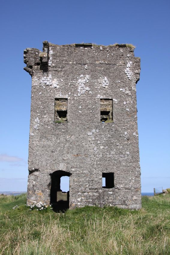
(1) Introduction

The present survey, undertaken in August 2011, was commissioned by De Courcey
Development Ltd as part of a planned conservation scheme on the Napoleonic war period
signaling station in the townland of Lispatrick Upper, on the Old Head of Kinsale, County
Cork. It is a level three inventory, which comprises laser scanned external elevations,
detailed photographic surveys and descriptions of the surviving fabric and the principal
associated features such as the enclosing embankment.

In the aftermath of the failed French invasion of 1796 and in the years leading up to the
Napoleonic Wars, a network of signalling stations was established around the Irish coast.
The main period of activity occurred in the years 1804-6, with many of the towers being, for
the most part, ‘defensible guardhouses’ or signal towers. The first of these were
constructed in west Cork in 1804, and generally took the form of a square, two/three-storey
masonry tower, with an entrance at first-floor level, a machicolation over the door and with
bartizans at two opposing corners. Many of the Cork towers were also weather slated and
had an enclosing wall of either masonry or a turf bank. Good access roads were provided
for them and that at Bray Head on Valentia Island still has its original masonry culverts,
which carried the road over hillside streams. The signalling system consisted of a mast
(usually an old topmast) up to 50 ft (15.24 m) high, surmounted by a cap that helped to
secure the flagstaff and a 30 ft (9.14 m) spar set at an angle from the main mast. From this
were hung a rectangular flag, a blue pendant and four black balls, all of which were
arranged in various combinations to form different signals. A total of 81 signalling stations
were established in Ireland, of which the Pigeon House Fort in Dublin was the first post in
the chain, but, by 1809, most of these had been abandoned, although some were re-used
during the American War of 1812-14 (Kerrigan 1993, 156ff).

In all some sixteen signal towers were constructed along the county Cork coastline in the
period 1804-6, at Britfieldstown, Dunbogey, Knockadoon, Ballylinchy, Ballymacredmond,
Ballyroon Mountain, Canalough, Cloghane, Derrycreeveen, Galley Head (Dunnycove),
Clear Island, Gortacrossig, Knock, Mallavoge and Dursey Island (Power et al 1992, 360-2;
1994, 291-2).
(2) Lispatrick Upper

The Lispatrick signal tower (Cork Archaeological Survey, Mon. 3878) is a square, two-
storey structure, measuring externally 5.67m on all sides. Its north wall thickens to a
central point externally to accommodate a chimney flue. Machicolations are present on
the north-east and north-west corners and a larger one is centrally located on the
southern side over the main entrance.
A concrete trigonometrical point is located just north of the tower.

(2.1) Western exterior elevation

The only entrance to the ground floor is on this side, near the north-western corner.
There is one window on the ground floor and two on the first floor. The façade is
weather-slated with render holding the slates. Most are now either broken or missing
completely with the largest number surviving above the first floor windows and close to
the machicolation on the north-west corner. Many of the slates visible have nail holes
present, but these are not present in every slate. A quoin is missing from the north-west
corner. Three coping stones survive on the top of the wall, two in the centre and the
other towards the south-west corner.

The machicolation in the north-west corner has only its two sides present; its floor is
missing. Access to it would have been from the wall-walk around the roof. There is no
obvious stone debris on the ground below the feature, suggesting that its collapse was
not recent. There is a noticeable horizontal ridge of mortar immediately below the ground
floor window. Although no slates survive below this ridge, a thin mortar render is present,
but this ridge does not extend as far as the doorway. Two nails are present 14cm below
the mortar ridge, possibly indicating that some form of low, lean-to structure was
present. The area around the doorway is lightly rendered with no trace of slating on the
mortar, which would suggest that this area was re-furbished at some point.

The doorway has a simple segmental arch on the exterior with the remains of a timber
lintel with a single course of stones under a shallow arch. It is flat-headed on the interior.
Based on the lack of mortar on the inner faces of the jambs, the door appears to have
been flush with the exterior of the building. The doorway is splayed with a greater splay
on its northern side. There is no sign of any bolthole or drawbar slot on either side. The
threshold may be lower than its original level as some stones appear to have been
removed.

There is one rectangular (almost square) window ope at ground floor level with two on
the first floor level. All appear to originally have had slate/shale sills. Those on the upper
level are not visible while that on the ground floor window has suffered greatly from
erosion and damage.

         Fig. 1 Ground plan of Lispatrick signal tower (after Kerrigan 1993)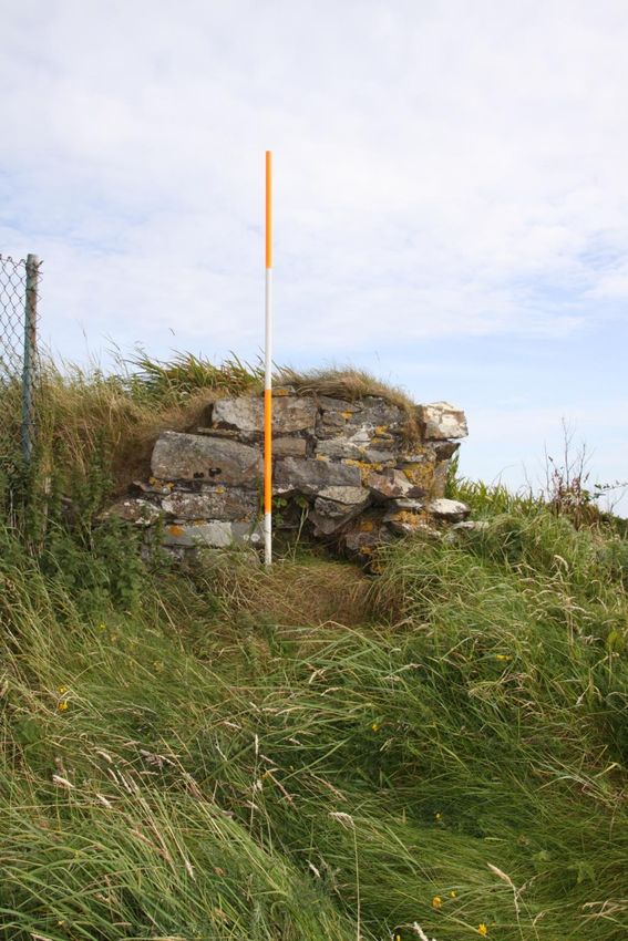
Fig. 2 Laser scan of western elevation (grid boxes are 1m square)
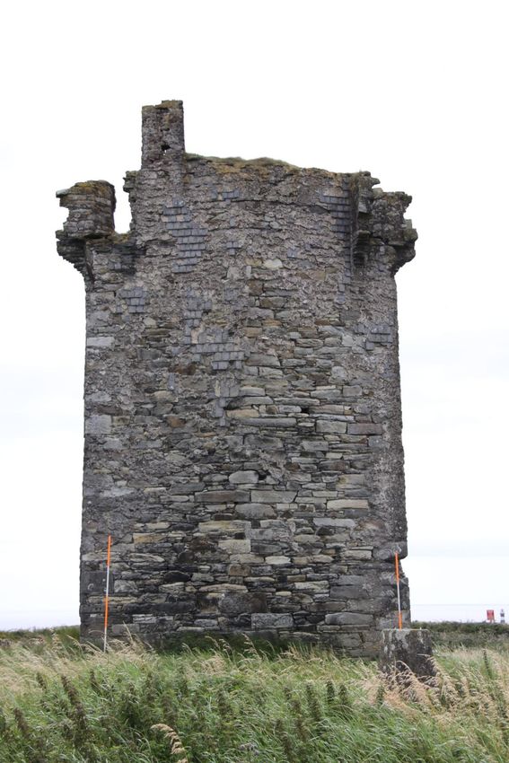
Fig. 3 Western elevation
(2. 2) Northern exterior elevation

This wall contains a central chimney flue and as a result it is thicker at its midpoint. The
weather slating here survives best on the north-eastern side with most missing from the
remainder of the elevation. No openings of any type are present apart for the
machicolations at the north-east and north-west corners. A chimney, constructed with
hand-made, clamp-fired brick was constructed next to the north-east machicolation.
Originally this chimney would have been rendered but much of this is now gone. None of
the original coping stones survive on this elevation.
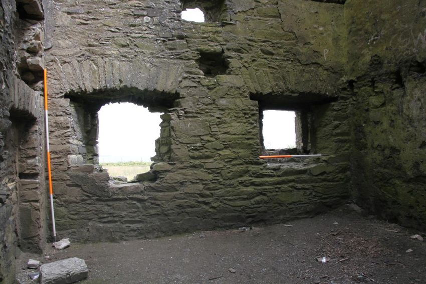
Fig. 4 Laser scan of northern elevation (grid boxes are 1m square)
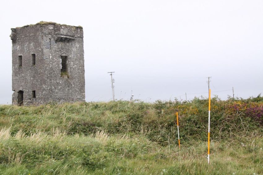
Fig. 5 Northern elevation

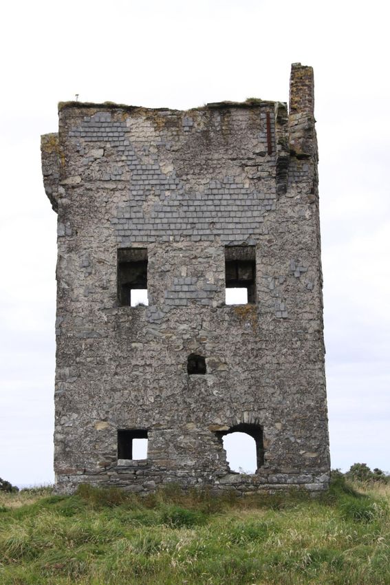
(2. 3) Eastern exterior elevation

The façade is weather slated with many surviving above the first floor windows. On this
elevation, four window opes survive, two on each floor. The ground floor ope in the
north-east has severe damage to its base and southern side. The lower windows are
square in shape with a segmental arch over, while those on the upper floor are
rectangular. For the most part, the individual sills are either missing or very weathered.
There is a small square opening located between the ground floor and first floor windows
and centrally placed between the northern and southern windows. There are no
surviving coping stones in evidence on this elevation.
Fig. 6 Laser scan of eastern elevation (grid boxes are 1m square)
Fig. 7 Eastern elevation
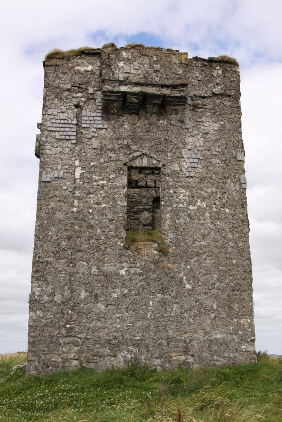
(2. 4) Southern exterior elevation

This has a single centrally placed doorway at first floor level with a large machicolation
over it at wall-walk level. An external stairs would have given access to the first floor.
Most of the weather slating on this side no longer survives, although an area survives
between the machicolation and the top of the flat-headed doorway. There is a slot on
either side of the door where the jamb meets the sill, which would have originally served
to anchor the timber stairs. Over the doorway there is an inverted ‘V’ shape visible in the
rendering, possibly suggesting some form of covering or protection for the door. If this
was the case, this must have been attached to the stairs as there is no trace of it being
fixed to the exterior of the wall.

The machicolation, which is also weather slated, has three openings in its base to cover
the door below. No coping stones are present on the feature but three survive on this
side of the tower. There is a horizontal band of slate/shale close to the base of the
machicolation, which has not been covered with render.

A vertical linear scar is visible in the weather slating near the south-western corner of
this face, which appears to start at, or just below, the base of the parapet. A small
square opening is present at its top and there is evidence of iron brackets, nails and nail
holes on either side of the feature. This appears to have accommodated rain water
goods.
Fig. 8 Laser scan of southern elevation (grid boxes are 1m square)
Fig. 9 Southern elevation
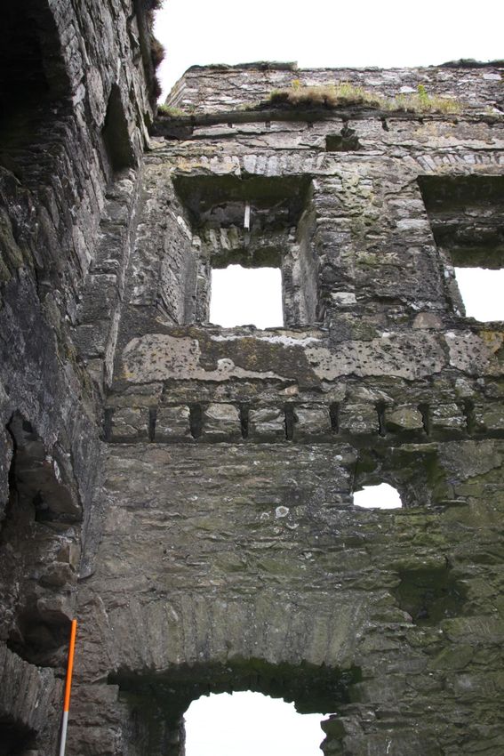
(3) The interior

The Lispatrick tower measures 4.27m internally, except for the western side which is
4.30m. This compares well those at Canalough (4.22m) and Gortacrossig Head (4.27m),
although for the most part the internal and external dimensions of the Cork county
towers exhibit substantial variation. The floor is comprised of silt with some medium
stones and modern debris present. This rises up from the entrance in the western wall
and is highest around the edges of the interior. There is a very small area of possible
cobbling in front of the fireplace.

(3. 1)The interior western elevation

The doorway has a greater splay on its northern side and has a timber lintel with a single
course of stones under a shallow segmental arch, while on the interior it is flat -headed.
The doorway is 2.20m high on the inside but the sill has been reduced by c. 0.10m. The
window in the south-west corner is square in shape and set in a splayed embrasure. The
area beneath the sill has been hollowed out with a single large angled stone present;
otherwise this feature looks quite crude with the sides of it being rough stone. A timber
lintel survives. The wall has an overall thickness on 0.66m. There is a possible joist hole
in the north-west corner with another in the centre of the wall over the window ope.
Fourteen joist holes mark the level of the first floor as well as an indentation in the mortar
rendering.

The first floor window embrasures are rectangular and larger in format to that on the
ground floor, but are identical in construction. Their overall dimensions are c. 1.40m high
by c. 0.65m wide. The area above the opes is recessed, with vertical slots for timber
battens: this is c. 0.50m high. Horizontal slots for battens are present on the splayed
sides with some timbers still surviving. The windows have flat segmental heads. Above
the windows is a line of rough masonry that marks the ceiling/roof level.

Centrally located above this rough masonry is a sub-rectangular opening c. 0.30-0.40m
wide and c. 0.20m high which is mirrored on the east wall. Above this is a wall plate slot
with nine joist holes for the ceiling/base of the roof.
There is a different style of opening for the principal rafters located in the corners of the
building. The best surviving example is in the south-west corner. The top of this is clearly
angled upwards, perhaps indicating that a pyramidal type of roof was present with
horizontal joists below that forming the ceiling of the first floor. These angled slots are
much damaged in the south-east and north-east corner and that in the north-west corner
cannot be clearly seen from ground level. It would appear to make more sense for a flat
roof to have been employed, as this would enabled easier access by ladder to the roof in
the event of an emergency. However, would a flat roof- even a strongly built one- last
lasted sufficiently long enough? Coping stones are in evidence on the interior of the
main walls. The interior of the parapet is weather slated as is the splayed entrance to the
machicolation.
Fig. 10 Interior western elevation
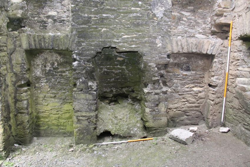
(3. 2)The interior northern elevation

This wall contains two centrally located fireplaces and has nearly full length recesses for
wall cupboards flanking the chimney on the ground floor. These are divided into a larger
rectangular lower recess with a square one above that: the first floor has single large
recesses. The fireplace on the ground floor is missing most of its segmental arched
head but some of the springing remains. The hearth is filled with what appears to be
modern mortar forming an angled panel across most of the fireplace. The fireplace on
the upper floor is identical but is in better condition.

The two rectangular recesses on the ground floor measure 1.85m high by 0.90m wide. A
narrow masonry band 0.31m high separates these from the upper recesses which are
0.84m high and 0.90m wide. Both are 0.20m deep. Slots for timber battens are present
at the rear and on the sides of the recesses. Parts of the sides of the recesses that
adjoin the fireplace are damaged. The larger wall cupboard recesses have shallow
almost flat segmental arches overhead while the square ones have timber lintels.

There are square joist holes in the corners of the wall between the recesses on the
ground floor with two similar holes at a higher level immediately below the fireplace on
the first floor. The latter ones may be to provide additional support for any hearth stone
placed in front of the fireplace; otherwise the fireplace would be quite shallow.
The wall cupboards on either side of the fireplace and chimney on the first floor are
identical in width to the others and are 2.45m high. That on the north-east corner is
rendered internally. Shallow slots on the sides probably indicate the locations of shelves.
Fig. 11 Interior northern elevation

(3. 3)The interior eastern elevation

This has two splayed window embrasures at ground floor level and another two at first
floor level. These are identical in shape and dimensions to those in the other walls. The
lower opes measuring 0.64m wide externally and 1.24m internally. The southern side of
the north-eastern opening is missing. The wall is 0.70m thick.

There is a large sub-rectangular opening centrally located above the ground floor and
first floor windows and which continues through the thickness of the wall to the exterior.
This measures 0.60m wide by 0.37m. It is splayed and flat-sided with a timber sill on its
inner half. The masonry on the outer part of the opening is rougher in appearance.
Immediately over this are the fourteen joist slots for the upper floor. The upper part of the
north-eastern window is in a poor condition with several stones missing.
The area over the first floor window embrasures is identical to that on the opposite wall
with nine joist slots present, all in good condition. There is a large sub-rectangular
opening below the joist holes as in the west wall. The inner coping on the main wall
survives only on the northern end. No weather slating survives on the inner face of the
parapet wall.

                            Fig. 12 Interior eastern elevation
(3. 4)The interior southern elevation The only surviving opening in this wall is for a door which would have been accessed by an external stairs. This measures 0.91m on its exterior face and is 1.95m high. The opening is splayed with the western side being more pronounced to allow the door to open back. A spud hole is present on the bottom at this side, none is present on top. Below and to either side of the doorway are eight slots or holes, in two groups of four. These are at the same height as the top of the window embrasures on the east and west walls. There are no corresponding holes on the northern wall (with the fireplace and wall cupboards). The function of these is unclear; but these may have, perhaps, been associated with some sort of a platform or shelving. Two rectangular slots are present below the doorway and below the eight slots described above. Their function is unclear, but they may have possibly supported an internal fixture. A linear break is visible in the plaster in the south-west corner. This appears to be an infilled area, corresponding to the probable location of the rainwater down pipe on the exterior face. There is a cavity behind the plaster infill, which measures 0.12m by 0.12m. On the limited section examined, the cavity may run most of the height of the wall. It does not extend through the thickness of the wall. This is likely to have been part of a feature originally designed to provide water inside the building. There is a shallow linear depression in the internal plaster approximately midway up the wall, running from the eastern side of the doorway up to the south-eastern window embrasure. This may be indicative of some form of timber batten, possibly to support panelling or some form of timber rail. There is nothing corresponding to this on the other side of the doorway. Twelve joist holes are visible in the wall between the top of the door and the wall-walk level. These correspond with openings on the interior of the western wall where nine openings are at the same level. On this wall the upper set of openings are less obvious with just three slots visible. This suggests that there was a separate ceiling in the tower with further joists above that forming part of the roof structure. No internal coping stones are present. Some weather slating is on the interior of the parapet wall, mostly on the splayed entrance into the machicolation.
(4)The enclosure around the tower

The signal tower is set within a sub-rectangular enclosure which has a fan-shaped
extension on its southern (seaward) side. This was where the signal mast, the most
important element of the complex, was located. The interior of the enclosure is covered
by long grass and occasional gorse, the latter mostly adjacent to the enclosing bank.
This area was examined visually and area that appeared to be a man-made feature was
probed with ranging rods to try and determine its nature and extent.

The enclosure as depicted on the 1st edition 6in OS (Sh. 137) coverage for the area, is
rectangular with an apsoidal feature to the south. Part of the apsoidal section survives,
as does the boundary wall to the west. However, for the most part, the southern sections
have been seriously disturbed by the construction of a loop of road in the 20th century,
linking the main access road with coastal route to Garrylucas.

Within the interior of the enclosure, only three possible features were found. The first
was a sub-rectangular raised platform which had an oval shaped depression in its
centre. This was located almost centrally in the fan-shaped extension and would also
have been directly in line with the doorway on the first floor of the tower. The sides of the
platform measured 6.90m (northern side), 5.50m (east), 4.70m (south) and 5.80m
(west). When probed this platform appeared to be stone built. The central depression
measured 1.90m (north-south) by 1.50m (east-west). It was 2.25m from the northern
edge of the platform to the northern edge of the depression and 1.80m from its western
edge to the western edge of the platform. A narrow linear trench 27.80m long was
located in the western part of the enclosure, approximately 10m from the tower. It varied
in depth from 0.20-0.28m; the vertical sides of this feature would tend to indicate that it is
relatively modern in date.

Access to the site is currently over various paths over the surrounding bank, all on the
southern side. These have been created over time by the visitors to the tower and have
resulted in the displacement of some of the stonework of the stone and turf bank. The
original entrance is shown on the first edition 6-inch OS map (1842) as being a
passageway leading from the roadway east of the site up to the edge of the enclosure.
The roadway that runs south and west of the site is of mid-twentieth century date.

The original site boundary has been removed from its north-western corner through the
north-eastern corner to the mid-point of the eastern side. What was the southern side of
the entrance passageway now forms, along with a post and wire fence, the boundary
between the site and the Lusitania Memorial. The location of the northern boundary wall
of the passageway was verified by probing, where a distinct band of stone was located
c. 4m north of and running parallel to the existing boundary wall.

The boundary takes the form of a stone faced bank. It could not be determined due to
vegetation growth if the enclosing element was a stone wall or a stone faced earthen
bank. Where the stonework was exposed to its greatest extent in the south-east
quadrant, the random rubble un-coursed wall stood to a height of 1.25m. It had a vertical
face. The width of the bank here was c.2.50m. No stone facing was visible on any part of
the exterior of the bank.

It is unclear if there was any form of ditch or fosse around the southern side of the
enclosure. While there does appear to be a relatively broad, shallow depression
between the roadway and the bank, this is intermittent and is not noticeable in the south-
western side. The depression may have been caused by the construction and repair of
the adjacent road raising levels there and creating the impression of a lower area next to
the enclosure. Much of this area is heavily obscured by gorse.
Fig. 13 Section of stone-faced enclosing bank
Fig. 14 Overgrown section of enclosing bank from south

.
(5) Recommendations
At present the interior of the site is overgrown, and thus the presence of important
original features is obscured. The first edition 6-inch and 25in OS maps indicate that
ancillary buildings were present on the site as at other surviving signal towers within the
county. These appear to be substantial structures (as for example at Knockadoon), and
its seems likely that their foundations would have survived. To this end, a series of
exploratory archaeological trenches, to determine the extent of such remains, should be
undertaken prior to any proposed conservation works.
These should include:
Sections through the surviving enclosure
A large cutting in the interior to locate the signal mast base and associated
features
Cuttings to locate the remains of the building indicated on the early editions of
the OSReferences Kerrigan, P. 1974 ‘The defences of Ireland 1793-1815, 3 –The signal towers’, An Cosantóir (July 1974), 225-7. Kerrigan, P. 1995 Castles and fortifications in Ireland 1485-1945. Cork. Power, D. et al. 1992 Archaeological inventory of County Cork. vol. 1 - West Cork. (Dublin). Power, D. et al. 1994 Archaeological inventory of County Cork, vol. 2 - East and South Cork. (Dublin).
You can also read