THE NEANIAS PROJECT BATHYMETRIC MAPPING AND PROCESSING GOES CLOUD - DHYG
←
→
Page content transcription
If your browser does not render page correctly, please read the page content below
Cloud service DOI: 10.23784/HN118-04
The NEANIAS project
Bathymetric mapping and processing goes cloud
An article by PAUL WINTERSTELLER, NIKOLAOS FOSKOLOS, CHRISTIAN FERREIRA, KONSTANTINOS KARANTZALOS, DANAI
LAMPRIDOU, KALLIOPI BAIKA, JAFAR ANBAR, JOSEP QUINTANA, STERGIOS KOKOROTSIKOS, CLAUDIO PISA and PARASKEVI NOMIKOU
The project Novel EOSC Services for Emerging Atmosphere, Underwater & Space Chal-
lenges (NEANIAS) targets Open Science practices, finally deployed through the Euro-
pean Open Science (EOSC) hub. From a technological perspective, NEANIAS aims to
deliver innovative thematic services that are flexible and open to accommodate the
needs of communities beyond their original definition, and able to adapt to neigh-
bouring cases, fostering reproducibility and reusability. The underwater service UW-
Bat, one out of nine thematic services, utilises the open source suite MB-System to
realise cloud-based bathymetry mapping and processing. The fast, uncomplicated,
web-based and thus platform-independent service allows professionals and amateurs
alike to easy access the world of bathymetry.
European Open Science Cloud | EOSC hub | cloud-based service | MB-System | Docker container
European Open Science Cloud | EOSC-Hub | cloudbasierter Dienst | MB-System | Docker-Container
Das Projekt Novel EOSC Services for Emerging Atmosphere, Underwater & Space Challenges (NEA-
NIAS), das Akronym steht für altgriechisch »Junger Mann«, bewirbt die offene und freie Wissenschaft
und spielt eine aktive und beispielhafte Rolle in der Umsetzung des European Open Science (EOSC)-
Ökosystems. Vom technischen Standpunkt aus betrachtet zielt NEANIAS auf die Veröffentlichung von
thematischen Diensten ab, die sich flexibel an die Bedürfnisse der verschiedenen Interessensgemein-
schaften anpassen können. Dazu gehört die Möglichkeit zur Adaption und eine Förderung der Repro-
duktion und Wiederverwendbarkeit, ganz im Sinne einer nachhaltigen Verwendung. Der Unterwas-
ser-Service UW-Bat, einer von insgesamt neun Diensten, benutzt die Open-Source-Suite MB-System,
um eine cloudbasierte Prozessierung und Generierung von bathymetrischen Karten zu ermöglichen.
Der schnelle, unkomplizierte, webbasierte und damit plattformunabhängige Dienst erlaubt Profis und
Amateuren gleichermaßen den Zugang zur Welt der Bathymetrie.
Authors Introduction zon 2020 research and innovation programme, via
The authors are part of the grant agreement No. 863448. Within NEANIAS, a
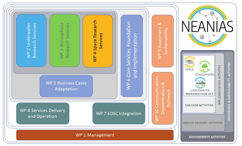
NEANIAS team. The NEANIAS Project total of ten work packages (WPs) were defined in
Paul Wintersteller (Teledyne As an EU Research and Innovation Action, NEANIAS order to fulfil the challenge. Every of the 21 part-
and Marum in Bremen), (neanias.eu) is a project that comprehensively ad- ners works in several of the WPs shown in Fig. 1.
Nikolaos Foskolos (Teledyne dresses the »Prototyping New Innovative Services« A brief overview describes the nine thematic, as
Reson in Denmark), Christian challenge set out in the »Roadmap for European well as the core services, respectively the content
Ferreira (Marum in Bremen), Open Science Cloud« (EOSC) foreseen actions. It of WP2, 3, 4 and 6.
Konstantinos Karantzalos (NTUA drives the co-design, delivery and integration into
in Athens), Danai Lampridou EOSC of innovative thematic and core services. The thematic services
(NKUA in Athens), Kalliopi While the thematic services are derived from state- Underwater thematic services (Fig. 2)
Baika (AMU in Marseille), Jafar of-the-art research assets and practices in three The Bathymetry Mapping (UW-BAT) from
Anbar (AMU in Marseille), Josep major sectors: underwater, atmospheric and space Hydroacoustic Data service will deliver an ad-
Quintana (Coronis Computing research, the core services will deliver reusable vanced user-friendly, cloud-based version of the
in Girona), Stergios Kokorotsikos cross-sector services that are generic yet able to be popular open-source software MB-System, uti-
(EUNICE in Berlin), Claudio Pisa further exploited and specialised both from internal lised for post-processing bathymetry and seafloor
(GARR in Rome), Paraskevi NEANIAS as well as external, other parties’ services. backscatter.
Nomikou (NKUA in Athens). In each sector it engages a diverse set of research The Seafloor Mosaicing (UW-MOS) from Optical
and business groups, practices and technologies Data service aims to provide an operational solu-
paul.wintersteller@teledyne.com which will design, develop and validate the services tion for large area representation (in the order of
towards a qualified cloud-based solution. tens of thousands of images) of the, predominant-
The project started in November 2019 and is ly flat, seafloor also addressing visibility limitations
funded by the European Union under the Hori- from the underwater medium.
30 Hydrographische Nachrichten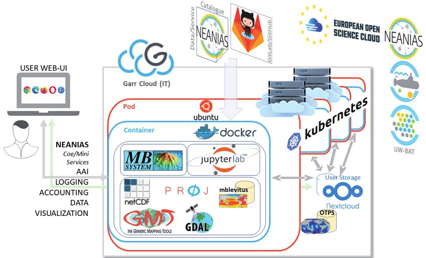
Cloud service

Fig. 1: NEANIAS work packages distributed around the different activities sketched in grey tones on the lower right corner

   The Seabed Classification (UW-MM) from Multi-                 existing workflow for map making and mosaicing
spectral, Multibeam Data service will deliver a user-            of multidimensional map images based on open
friendly cloud-based solution integrating cutting-               source software such as Unimap and Montage.
edge machine learning frameworks for mapping                        The Structure Detection on Large Scape Maps
several seabed classes, validated for archaeologi-               with Machine Learning service will deliver a user-
cal, geohazards, energy and other applications.                  friendly cloud-based solution for innovative struc-
                                                                 ture detection (e.g. compact/extended sources,
Atmospheric thematic services                                    filaments), extended the popular CAESAR/CuTEx
The Greenhouse Gases Flux Density Monitoring                     tools with machine learning frameworks.
service will deliver an operational workflow for es-
timating flux density and fluxes of gases, aerosol,              Core reusable services
energy from data obtained from specifically set                  The Open Science life cycle support service ena-
meteorological stations, validated towards stand-                bles on one hand NEANIAS integration with EOSC
ardised, regularised processes.                                  hub and on the other hand also providers, services
   The Atmospheric Perturbations and Compo-                      and users to publish and locate resources in need
nents Monitoring service will perform all required               (be it data and services) as well to validate data in a
analytics of atmospheric and meteorological data                 machine assisted user-driven manner.
to estimate possible correlations of gaseous and                   EOSC hub cloud integration service allow other
particulate components of the atmosphere with                    NEANIAS services to integrate with other services
earthquake and volcanic processes.                               and resource providers and consume and share
   The Air Quality Estimation, Monitoring and Fore-              storage, computation, service and data resources.
casting service will deliver a novel cloud-based so-               AI (artificial intelligence) service provides a re-
lution providing crucial information and products                usable substrate for machine learning and other
to a variety of stakeholder in agriculture, urban/
city authorities, health, insurance agencies and
relative governmental authorities.

Space thematic services
The FAIR Data Management and Visualisation ser-
vice will provide an advanced operational solution
for data management and visualisation service for
space FAIR data based on widespread and popular
tools like VisIVO, ADN and PlanetServer.
  The Map Making and Mosaicing of Multidi-
mensional Space Images service will deliver a
                                                                  Fig. 2: Pictogram of the underwater thematic services
user-friendly cloud-based version of the already

HN 118 — 02/2021                                                                                                                       31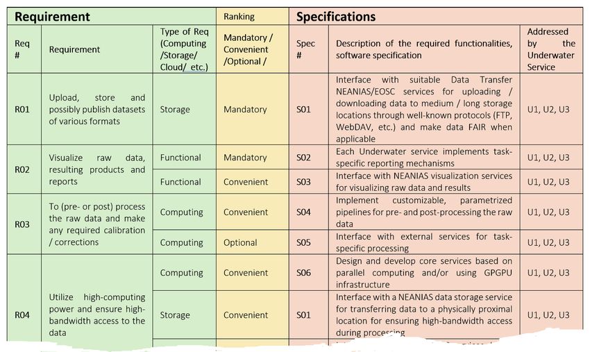
Cloud service
computational intelligence approaches that allow focus are researchers and students, e.g. archaeolo-
NEANIAS users and services to provide beyond gists, geoscientists, biologists, physicists, ocean-
state-of-the-art solutions to problems raised by ographers as well as environmental engineers,
research sector cases. technicians, renewable energy planners or users
Visualisation service provides a multi-faceted so- working in the field of underwater robotics and/
lution to visualisation spanning from 2D/3D spatio or computer vision/machine learning who like to
temporal data visualisation to composite 2D/3D view and process recorded raw multibeam echo
visualisation of data of higher dimensionality and sounder (MBES) data. With respect to the global
to support demanding virtual/augmented reality Seabed 2030 efforts (Mayer et al. 2018) such a ser-
requirements. vice could be of particular interest.
The idea of utilising MB-System for a cloud ser-
This publication aims to a better understanding of vice that enhances a wider community to create
how thematic cloud services in the field of marine their own bathymetric maps out of raw data sets
geodesy and habitat mapping could be realised and came up based on a request of the National and
therefore seeks the audience of the hydrographic/ Kapodistrian University of Athens (NKUA) and
hydroacoustic community by focusing on the WP2 National Technical University of Athens (NTUA).
underwater service »Bathymetry Mapping« (U1). This By that time, several engineers and technicians
service is mainly driven and lead by Teledyne and of Marum already contributed code to the open-
the University of Bremen/Marum, but with strong source software. A member of Marum is currently
support from all underwater services participants part of the MB-System core-developer team. Due
regarding validation, evaluation and development to changes at institute the lead of the project was
towards a common user interface and connectivity transferred to Teledyne Reson A/S in April 2020.
between the services. The development of this U1 Since then, members of the company build the
service would not be possible without the contri- core team around this project with kind support
bution of all the NEANIAS members who cover the from Marum and the MB-System team.
fields of e.g. project management, public relation, MB-System is running in-house at the University
business models, core and micro service develop- of Bremen and worldwide in many other institutes
ment, and the integration of our thematic services and universities, as a bathymetry and backscatter
to EOSC hub, as mentioned in Fig. 1. post-processing tool for MBES data sets. It is on a
technology readiness level (TRL) 6, has been vali-
The bathymetry mapping service dated using different data sets from various ven-
Knowing the depth, shape and type of the seafloor dors and is under constant maintenance through
bathymetry and its hydroacoustic backscatter is the open-source community.
fundamental for understanding geomorphology Furthermore, MB-System is capable to realise
and habitats, ocean circulation, tides, tsunami fore- navigation correction for AUV/ROV recorded ba-
casting, fishing resources, sediment transport, bot- thymetry. This is crucial not just for bathymetry
tom currents, environmental change, underwater but for other acquired data sets like CTD, photos,
geohazards, submerged remains of underwater videos. Underwater-recorded bathymetry lacks ac-
cultural heritage, such as shipwrecks, artefacts and curacy since GNSS/RTK (Global Navigation Satellite
sunken cities, topography of archaeological sites, Service/Real-Time Kinematics) information cannot
cable and pipeline routing, mineral extraction, oil be used directly. Several devices are necessary to
and gas exploration and development, infrastruc- accurately steer and position underwater devices
ture construction and maintenance and much like AUV/ROV. Next to GNSS and RTK, which can
more. only be used directly on the sea surface, USBL/LBL
Therefore, the aim is to provide a user-friendly (Ultra Short/Long Base Line underwater position-
service to exhibit and post-process bathym- ing) and DVL (Doppler Velocity Log) and even the
etry and seafloor backscatter data sets. Currently revolutions per minute of the vehicles propellers
available software products like Teledyne Caris are taken into account when solving the algo-
Hips & Sips (teledynecaris.com/en/products/ rithms for positioning by utilising Kalman filters
hips-and-sips/), QPS Qimera/Fledermaus (qps.nl), during acquisition. Still, the uncertainties are large
EIVA (eiva.com), HYPACK (hypack.com), SonarWiz unless the devices are operating very close to the
(chesapeaketech.com/products/sonarwiz-post- seafloor and are capable to use photo/video infor-
processing), Globe (Poncelet et al. 2020) or MB- mation also for navigation decision making pro-
System (Caress and Chayes 2017; www.mbari.org/ cesses. This is rather seldom the case.
products/research-software/mb-system) require Nevertheless, due to its numerous software de-
a certain knowledge which is predominantly re- pendencies, MB-System currently requires a cer-
served to hydrographers or researchers in the field tain knowledge of the operating systems (Unix/
of hydroacoustic. The goal is to reach a broader Linux) and in the command line-based installation
audience of users which are interested in ocean and execution of the different packages. On the
mapping and its tools for several reasons. In the other hand, utilising MB-System for bathymetric
32 Hydrographische Nachrichten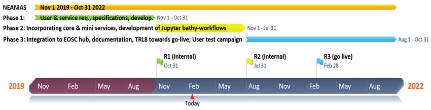
Cloud service
and backscatter post-processing is a sustainable end-user perspective. The user story describes the
solution but as a matter of consequence when type of user, what they want and why. A user story
using command line, it lacks certain (UI driven) is on a high level and helps to create a simplified
workflows and logging of what have been ap- description of a requirement. Usually a user story
plied to the data. Therefore the user is obliged to provides in one sentence enough information re-
document manually which commands he/she has lated to the described product feature, for which
executed. A disadvantage with respect to e.g. line- the development team can conduct a reasonable
age metadata for quality standards or confidence workload estimation. Furthermore, the user story
levels with respect to the post-processing and is used in planning meetings to enable the devel-
common data quality. opment team to design and implement the prod-
uct features.
User requirements and aim A user story typically has a predefined structure:
The user requirements have been initially formed As a , I want to so that .
instrument used in agile software development to For all underwater services we came across the
capture a description of a software feature from an following, common needs in Table 1.
ID End-user User requirement Reason
R1 All targeted Upload, store and possibly publish data sets of To process end-user data with different services
various formats and be able to store them and make them avail-
able to other users
R2 All targeted Visualise raw data as well as resulting products For a first glance, viewing the raw/vendor data
and reports (map or mosaic, etc.); inspect and evaluate the
results
R3 All targeted To (pre- or post-)process the raw data and To correct the data (e.g. image correction,
make any required calibration/ corrections photogrammetrically rectify, sound velocity
(parametrisations) correct, tide correction, etc.)
R4 All targeted Utilise high-computing power and ensure high- To solve demanding (post-)processing tasks
bandwidth access to the data operating on large inputs
R5 All targeted Produce bathymetric maps (digital terrain To perform archaeological, oil and gas, renew-
models), backscatter mosaics, photomosaics, able energy, geological, geohazard and insur-
multifrequency-based seabed classification ance related tasks
maps and other related products
R6 All targeted Document the workflow For quality assurance, traceability, reproducibility
and backlogging
R7 All targeted Export the results in various file formats Facilitate the exchange of data sets between
users
R8 Archaeologist To produce geospatial products/ maps with In order to comprehend archaeological targets
adequate precision from interdisciplinary data in data sets and fulfil archaeological survey
sets requirements
R9 Archaeologist To have the possibility to review the To be able to understand the exact location of
georeference of a given data set an archaeological target (such as a shipwreck) as
data sets are georeferenced differently
R10 Archaeologist To achieve very high spatial accuracy in the In order for the result (mapping, 3D model) to be
delivered products (e.g. to the millimetre) used as accurate archaeological documentation
R11 Archaeologist To achieve high quality texture on the delivered For reconnaissance purposes: in order to be able
products to distinguish archaeological targets (shipwrecks
from rocks, etc.)
R12 Oil, gas and Classify the seabed type For the development of the design and instal-
renewable lation of submerged tubes and transmission
energy engineer cables, the route design of the transmission-
ing cable and the appropriate selection of the
submarine cable type
R13 Marine geologist Classify the seabed type and structure To assess geohazards and study geological
phenomena
R14 Robotics and Plan AUV/ROV trajectories For better AUV/ROV navigation as it is based
computer vision on GPS, DVL and USBL/LBL information and
engineer often not accurate enough to be used right
away for bathymetric or photogrammetric
post-processing
Table 1: User stories for all underwater services
HN 118 — 02/2021 33
Cloud service

                 ID    Priority           Value              Acceptance

                 R1    High               High               User interface (UI) provides functionalities for uploading/downloading data, relying
                                                             on a data transfer service
                 R2    Medium             High               UI provides functionalities to visualise the data and the results
                 R3    High               High               The UI will support manual processing and apply suitable corrections to the data via
                                                             graphical tools
                 R4    High               High               Data will be accessible from physically proximal locations and the developed algo-
                                                             rithms will allow when required parallel processing and exploitation of any available
                                                             GPGPU resources
                 R5    High               High               Implement thematic services that either as stand-alone or in combination produce
                                                             the required final products
                 R6    Medium             High               Provide proper support to the logging, backlogging, auditing and accounting
                                                             functionalities offered by the core services
                 R7    Low                Medium             Implement data serialisation processes supporting several widely used data for-
                                                             mats. Rely on a data transfer service for storing and publishing.
                 R8    Medium             Medium             Provide detailed reporting and evaluation information to assess the quality of the
                                                             produced results
                 R9    Low                Medium             Implement reoreference related data inspection and quality assurance mechanisms

                 R10   Medium             Medium             Provide detailed reporting and evaluation information to assess the quality of the
                                                             produced results
                 R11   Medium             Medium             Rely on interactive visualisation methods/services for quality assurance

                 R12   High               High               The service will be able to produce the classified seabed map

                 R13   Medium             High               The service will be able to produce the classified sea as well as geomorphological
                                                             features when appropriate
                 R14   Medium             Medium             The service will be able to deliver photomosaics which will aid underwater naviga-
                                                             tion tasks

                Table 2: User stories ranked and linked to a level of priority

                  Then the aforementioned user stories and re-                       Service specification
                quirements were linked with a level of priority                      The service requirements have initially been ar-
                and value based on end-user recommendations                          ranged according to their type. Five distinct cat-
                (Table 2). Also, the manner to confirm their accept-                 egories have been recognised, more specifically:
                ance was marked down.                                                storage, computing, cloud, functional and quality

                Fig. 3: Table with service specifications, partly shown

34                                                                                                           Hydrographische Nachrichten
Cloud service
Fig. 4: The different components towards the deployment of the U1 service to EOSC including the core software,
the user interface, the service/data catalogue as well as the data and supplementary material
requirements. The first two are related to the ac- code of the service that does the work the user
cess and usage of storage and computing resourc- requests. As according to the user requirements
es by the services. Cloud requirements rely on the and service specifications several questions were
features of the cloud infrastructure which will host raised: Who will authorise a user to use the service,
the service while functional requirements regard allow upload and download data, provide (com-
specific features to be made available from the mon) graphical user interfaces (GUI), visualise re-
services. The quality requirements are necessary sults, manage a user’s workflow, enable sharing of
for assessing the quality of the services’ results. results? And how to find the service and its docu-
The table in Fig. 3 exemplarily presents the mentation in the world wide web? Fig. 4 presents
specifications of the underwater services which the different software components and modules
have been defined to address the user require- currently utilised or developed and validated for
ments (Table 1 and Table 2). The table presents the U1 service. This approach reflects a similar de-
the description of each requirement, its type and ployment architecture of all underwater services.
ranking according to the aspects described above, In general, the software and service development
a detailed description of the specifications which cycle of the underwater services will closely ob-
have been defined for satisfying the correspond- serve the recommendations and guidelines devel-
ing requirement and, finally, the underwater ser- oped in the context of WP 7 and 8 (Service deliv-
vices which should respect the specification. The ery and EOSC integration). Moreover, the core and
specifications have been ranked as »mandatory«, micro services development and implementation
»convenient« and »optional«. (WP 6) will foster the service usability and TRL to-
wards 8.
Software development plan The scheme shown in Fig. 4 visualises a Docker
High flexibility, sustainability by moving fast from container deployed on a virtual machine in the
development towards testing and production, GARR cloud. The latter is an OpenStack and Kuber-
and accommodating for an enormous level of netes based cloud infrastructure in Italy, built and
complexity, when utilising multiple program- maintained by Consortium GARR. Kubernetes is re-
ming languages, frameworks and architectures, sponsible for spawning one to many Docker con-
are challenges when deploying a cloud service. tainers (on one or several virtual machines/pods)
Therefore, it seems obvious to containerise our based on one or multiple user requests. Several
services via Docker (docker.com) and manage the core and mini services will aid with respect to au-
deployment on one or different nodes or virtual thorisation, logging, accounting, visualising or sim-
machines/pods with an orchestrator like Kuber- ply up- and download data to a Nextcloud stor-
netes (K8s). But a container and its orchestration age connected to the Docker container. Once the
are not the only thing one needs around the initial container is set up, the user is able to access MB-
HN 118 — 02/2021 35Cloud service
In many aspects, this means that the NEANIAS
EOSC services, currently under implementation,
have the potential of being useful, if not indispen-
sable, to a great majority of the scientific under-
water community internationally, regardless of dif-
ferent scientific goals and approaches for specific
final results and products. Underwater archaeolo-
gists, marine geologists, environmental scientists
Fig. 5: Timeline for the Bathymetry Mapping Cloud Service
and energy developers share common require-
ments regarding the services to be developed,
System through a browser-based and launched as the analysis of the user requirements revealed.
JupyterLab. All dependencies of MB-System and Therefore, through this task we were able to reach
the Jupyter-workflow were installed previously in one of the goals of our work and demonstrate the
a Docker image. The sources are stored in GitLab/ applicability of the new cross-cutting services for
GitHub. diverse user-communities.
The expected timeline for the release of the U1 However, where some case studies showed dis-
service is shown in Fig. 5. crepancies in requirements, we aimed at a unified
approach in order to co-design services reflecting
First results and conclusions at the time the broader needs. At the same time, we also tried
This article summarises and contextualises the NE- to address specific needs and products, through
ANIAS and in particular the underwater team ef- personalised use of the services, when this is pos-
forts within the first year of the project by defining sible.
the services requirements of the end-users. These The future steps are already defined by the de-
requirements have been identified and assessed scription of the required functionality and the cor-
to set the co-design and service specifications for responding software development plan needed
the software development plan on the three in- for each service, as well as the detailed allocation
novative thematic EOSC service branches that NE- of tasks. The next steps continue with the work
ANIAS will implement, co-aligned to its developed towards the first release of the services, followed
core and mini services. by the first evaluation and assessment by the end-
These requirements in the scientific analysis user community and the external advisors.
are fundamental regardless of the individual ob- It is a great advantage that the end-user’s part-
jectives of each research and underwater survey: ners of NEANIAS are providing unpublished new
From ocean circulation to environmental issues databases, namely data from underwater archaeo-
and underwater geohazards to the promotion of logical research, environmental and marine sur-
underwater cultural heritage to cable and pipe veys, as well as big development projects of the
routing and oil and gas exploration, all user-end renewable energy companies. All new data sets
communities share the same or equivalent re- will provide a first valuable feedback in the first
quirements from the NEANIAS underwater soft- release of the NEANIAS innovative services, that is
ware services. the next step of our project. //
References
Poncelet, Cyrille; Gael Billant; Marie-Paule Corre (2020): Globe Mayer Larry; Martin Jakobsson et al. (2018): The Nippon
(GLobal Oceanographic Bathymetry Explorer) Software. Foundation—GEBCO Seabed 2030 Project: The Quest
SEANOE, DOI: 10.17882/70460 to See the World’s Oceans Completely Mapped by 2030.
Caress, David W.; Dale N. Chayes (2017): MB-System Seafloor Geosciences, DOI: 10.3390/geosciences8020063
Mapping Software. www.mbari.org/products/research- Schmidt, Val; Dale N. Chayes; David W. Caress (initial release
software/mb-system 2004): The MB-System Cookbook; www3.mbari.org/data/
Klischies, Meike; Marcel Rothenbeck et al. (2018): AUV Abyss mbsystem/mbcookbook.pdf
workflow: autonomous deep sea exploration for ocean
research. IEEE/OES Autonomous Underwater Vehicle
Workshop (AUV), DOI: 10.1109/AUV.2018.8729722
36 Hydrographische NachrichtenYou can also read