The Peaks National Park (NP2): Management Development Plan 2013 2023 - St Helena Government
←
→
Page content transcription
If your browser does not render page correctly, please read the page content below
Peaks National Park Development Plan

       The Peaks National Park (NP2): Management
             Development Plan 2013 – 2023.
BACKGROUND.

This development plan aims to guide conservation management within the Peaks
National Park (PNP). It is intended to reflect the views of local communities and
other interest groups of St Helena. There is a need to interweave these interests with
national and international polices and laws signed by the St Helena Government
(SHG). By weaving these interests, opportunities for maintaining the Saint sense of
identity, managing ecosystem services (such as the PNP water catchment) and
increasing tourism can be realised. It is within this context that nature conservation
on St Helena will be carried forward.

Under the Land Development Control Plan (LDCP)1 23 National Conservation Areas
(NCAs) have been established. The next stage is to create Development Plans to
direct ongoing management of these areas. Of the 23 NCAs, 14 have been
designated for their natural and habitat features. The Development Plans will provide
the foundation for land use management within these locations to enhance their
ecological value. All of the ‘natural’ NCAs hold high numbers of native and endemic
species or valuable habitat for these species, for example, High Peak holds valuable
fragments of endemic cabbage tree woodland. Unfortunately, all of the NCAs are
being threatened by a suite of impacts including Invasive Non-Native Species (INNS)
and habitat loss. Thus, it is important that the development plans are effective and
take into account a wide range of viewpoints.

Many elements of the flora in the PNP are of considerable antiquity having occupied
St Helena for millions of years. The result is a high diversity of unique native and
endemic species which reflect a long period of isolation. These species are relicts of
types once found on the African continent. A high degree of ecological separation in
habitat use between species reflects rapid evolution of the early arriving species into
the numerous available habitat types. This diversity within the PNP adds to the
aesthetics of the location and offers a site of high scientific interest.

Over the past 25-30 years there has been a change in the way protected areas are
managed. This is being directed by national and international policy which place

1
  The principal policy document for regulating development is the Land Development Control Plan,
adopted in 2012. It sets out policies to guide development for three planning zones and for specific
topics including conserving the natural heritage. This Development Plan for the sets out more specific
policies and management applicable to the National Park, reflecting its characteristics and values.

                                                  1
Peaks National Park Development Plan
greater emphasis on collaborative work between local communities, civil society and
government. There is increased recognition of community rights, livelihood support
and empowerment. In addition, cultural aspects of the NCAs must be recognised to
ensure the historic value and traditional roles of the locations are accounted for. This
development plan has been devised to incorporate the views of the St Helena
community.
The PNP (map 1) provides a large percentage of the water catchment for the island.
Water provision within the park is an essential function for the inhabitants of St
Helena and must be central to any plan for the PNP. There is good evidence that
well-structured native vegetation is better at collecting and storing moisture from
clouds, and releasing water for drinking supplies and irrigation at an efficient rate.
Many of the INNS, such as a monoculture of New Zealand flax or forestry
plantations, are unable to offer the same service. This is the main example of a
‘provisioning’ ecosystem service2 within the park. Natural management to improve
the water catchment function offers a win-win situation. Thus, habitat management
for native species can offer a more robust water catchment. Such a situation
improves native habitats making the island increasingly attractive to walkers and
eco-tourists whilst providing a source of additional revenue for the island. At the
same time such management benefits the local community in a number of ways. A
more robust water provision function is perhaps the most obvious.
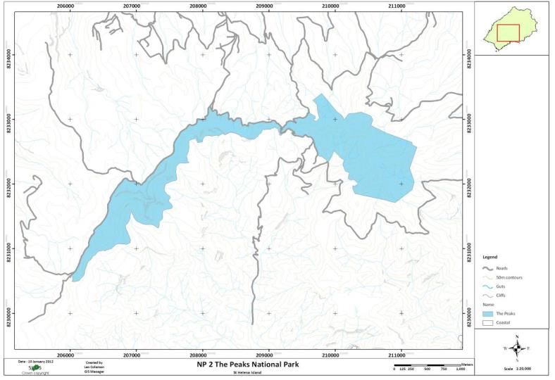
Map 1: the Peaks National Park arcs around the central ridge of St Helena and is contained wholly
within the LDCP Green Heartland.
2
Ecosystem services are the range of benefits people derive from nature. Broadly speaking these
include 1) the supply of environmental goods from ecosystems such as natural foodstuffs, medicinal
products and fresh water, 2) the role of ecosystems in regulating the earth’s natural systems such as
water purification and stabilisation, climate/air regulation, pollination and natural hazard regulation, 3)
the services required for the generation of other ecosystem services such as nutrient cycling,
photosynthesis and soil formation, and, 4) the non-material benefits human beings derive from natural
ecosystems such as recreation, aesthetic and spiritual appreciation as well as education.
2Peaks National Park Development Plan
A number of Multi-lateral Environmental Agreements have been extended to St
Helena. Many of these are pertinent to management within the PNP. For example,
the Ramsar Convention on Wetlands, the Convention on Biological Diversity, the
World Heritage Convention and CITES (Control in trade of endangered species)
have an element of influence within the PNP. In addition, St Helena has signed a
regional Invasive Species Strategy. These agreements help direct biodiversity and
habitat conservation as well as bio-security measures within signatory countries.
Finally, the development of conservation areas is vital to St Helena’s international
commitments. The primary commitments include the Convention on Biodiversity
measures such as the Programme of Work on Protected Areas and Aichi
Biodiversity Targets (Annex I). Importantly, such measures will assist with the
effective conservation of biodiversity with the PNP and the other NCAs concerned
primarily with the islands natural heritage.
LEGAL AND POLICY FRAMEWORK.
NCA Development Plans are requirements under the LDCP and are likely to be
required under new environmental law. LDCP zone policies will apply outside of
areas with NCA Development Plans. Where NCA Development Plans do exist
planning policies for that area defer to the NCA Development Plans. Thus, the
Development Plans will provide the higher tier of legislation within the NCAs.
The PNP lies entirely within the Green Heartland Zone formed under the LDCP. For
the area delineated as the PNP the following primary and secondary implementation
policies (Annex II) apply in their entirety for the Core and Isolated Hotspot Zones as
well as the Paths and Trails Zone [see section __ ‘Management Zones’]:
GH1 (Green Heartland 1): Primary policy ‘There will be a presumption in favour of
retaining the underdeveloped nature of the Green Heartland and its natural ecology.
The grant of development will therefore be strictly controlled by the following
implementation policies: -
Implementation Policy GH2: No development permission will be granted for
development which includes the construction of buildings above the contour line of
550m except for:
a. Development required for the conservation, interpretation, study and
appreciation of the natural ecology of the area (e.g. walk-ways, interpretation
centre etc.). (Ref LDCP 2012-2022)
3Peaks National Park Development Plan
For buffer zones and roadside verges all other GH policies apply except: -
a. G.H.2b: tourism related development within established forest areas in
the form of eco-lodges3 that will, as an element of the development
proposal, remain forested sufficient to conceal the development from any
viewpoint within the Peaks National Park or visible in any view towards the
national Park from a public road or public place.
b. G.H.2c: tourism related development in the area of Broad Bottom below
the contour line of 600m that will, as the first principle of its design detail,
and operation (including transport) be an example of international best
practice of sustainable development with the minimum disturbance to the
natural ecology of the area and the principal method of grassland
maintenance to remain pasture grazing.
The presumption through this plan will be for no development within the PNP in
recognition of its ecological and amenity value and the fragile nature of the area.
VISION:
To manage the native habitats and species of the PNP, for their intrinsic values and
for the ecosystem services including education, agriculture, forestry, recreation,
tourism and eco-tourism, to be valued by present and future generations.
GENERAL PRINCIPLES:
1: this document will allow SHG to develop a management regime for the PNP, and
NCAs in general, based on participation and consensus.
2: an important aspect of natural area management is to incorporate the plan into the
wider social, environmental and economic context.
3
Eco-lodge means residential accommodation available solely and continuously for tourist use,
including that no individual occupancy shall exceed a continuous period of 183 days, which is
designed, built and managed such that it is sustainable and makes the minimum impact on the
ecology and appearance of the area. Such development will not normally have vehicular access nor
mains serviced to the accommodation."
4Peaks National Park Development Plan
3: adjoining and nearby NCAs (Sandy Bay, Man and Horse) should be managed in
conjunction to enhance the biodiversity of each by increasing the available habitat
area.
4: wherever possible NCA management should be open to other community
initiatives such as SHAPE, the Duke of Edinburgh Award and student work
experience.
AIMS AND OBJECTIVES:
1: to conserve and enhance the specialist and typical St Helena habitats and species
within the PNP.
2: to encourage sustainable enjoyment of the PNP, it’s wildlife, habitats and scenery
3: to foster positive partnerships and encourage further volunteer groups
4: to enable sustainable economic use of the PNP resources where they do not
conflict with (2) and (3)
MANAGEMENT ZONES:
Under the Development Plan 5 different types of zones within the PNP have been
identified. Each type of zone will have different management action plans associated
with it, which will be devised later. The zones are:
Core zones: these areas that are already established as large management
sections that hold the best habitat patches. These areas include Diana’s
Peak, High Peak, The Depot and Casons.
Isolated hotspots: for the purposes of this development plan an isolated
hotspot can be defined as a location containing the remaining individual
specimens of any native or endemic species and the range of species
associated and dependent on them. These hotspots are sensitive, often small
areas, either inside or outside of core zones. They are critical to the survival of
individual species, plant or animal, and hence require highly specific and
targeted management.
Roadside verges: these provide much of the boundary of the PNP. These
verges can be corridors for both invasive and native species. The aim will be
to enhance their function as corridors).
Paths/Trails: these are essential for their amenity value. However,
management must be sensitive to ensure they do not further fragment
valuable management or further spread INNS during management operations
whilst also providing safe routes for walkers.
5Peaks National Park Development Plan
Buffer zone: these hold all the land outside of the above zones. This area will
act to protect he zones of active management. Ultimately the hope would be
to use this area to connect core zones and, importantly, the isolated hotspots.
KEY TARGETS AND ACTIONS.
An example of what key targets and actions under this plan could be:
2013
2014
2015
2016
2017
2018
2019
2020
2021
2022
2023
Conservation Area Action plans
zone/target needed Lead
Diana's Peak
National Park EMD
High Peak SHNT
Core zones Depot
Casons
Mount Vesey
Last wild false
gumwoods
Isolated Hotspots Bellflower
5 whitewoods
Mount Vesey
Roadside verges
Roadside verges
Paths/Trails
Paths/Trails
Buffer zone
Buffer zone
Public amenity Public amenity ESH (Tourism)
Funding for
Darwin Plus
implementation of action
plans Darwin
6Peaks National Park Development Plan
Annex I: Aichi Biodiversity Targets
Strategic Goal A: Address the underlying causes of biodiversity loss by
mainstreaming biodiversity across government and society
Strategic Goal B: Reduce the direct pressures on biodiversity and promote
sustainable use
Strategic Goal C: To improve the status of biodiversity by safeguarding
ecosystems, species and genetic diversity
Strategic Goal D: Enhance the benefits to all from biodiversity and ecosystem
services
Strategic Goal E: Enhance implementation through participatory planning,
knowledge management and capacity building
Strategic Goal A: Address the underlying causes of biodiversity loss by
mainstreaming biodiversity across government and society
Target 1
By 2020, at the latest, people are aware of the values of biodiversity and the steps
they can take to conserve and use it sustainably.
Target 2
By 2020, at the latest, biodiversity values have been integrated into national and
local development and poverty reduction strategies and planning processes and are
being incorporated into national accounting, as appropriate, and reporting systems.
Target 3
By 2020, at the latest, incentives, including subsidies, harmful to biodiversity are
eliminated, phased out or reformed in order to minimize or avoid negative impacts,
and positive incentives for the conservation and sustainable use of biodiversity are
developed and applied, consistent and in harmony with the Convention and other
relevant international obligations, taking into account national socio economic
conditions.
Target 4
By 2020, at the latest, Governments, business and stakeholders at all levels have
taken steps to achieve or have implemented plans for sustainable production and
consumption and have kept the impacts of use of natural resources well within safe
ecological limits.
Strategic Goal B: Reduce the direct pressures on biodiversity and promote
sustainable use
Target 5
By 2020, the rate of loss of all natural habitats, including forests, is at least halved
and where feasible brought close to zero, and degradation and fragmentation is
significantly reduced.
Target 6
By 2020 all fish and invertebrate stocks and aquatic plants are managed and
harvested sustainably, legally and applying ecosystem based approaches, so that
overfishing is avoided, recovery plans and measures are in place for all depleted
species, fisheries have no significant adverse impacts on threatened species and
7Peaks National Park Development Plan
vulnerable ecosystems and the impacts of fisheries on stocks, species and
ecosystems are within safe ecological limits.
Target 7
By 2020 areas under agriculture, aquaculture and forestry are managed sustainably,
ensuring conservation of biodiversity.
Target 8
By 2020, pollution, including from excess nutrients, has been brought to levels that
are not detrimental to ecosystem function and biodiversity.
Target 9
By 2020, invasive alien species and pathways are identified and prioritized, priority
species are controlled or eradicated, and measures are in place to manage
pathways to prevent their introduction and establishment.
Target 10
By 2015, the multiple anthropogenic pressures on coral reefs, and other vulnerable
ecosystems impacted by climate change or ocean acidification are minimized, so as
to maintain their integrity and functioning.
Strategic Goal C: To improve the status of biodiversity by safeguarding
ecosystems, species and genetic diversity
Target 11
By 2020, at least 17 per cent of terrestrial and inland water, and 10 per cent of
coastal and marine areas, especially areas of particular importance for biodiversity
and ecosystem services, are conserved through effectively and equitably managed,
ecologically representative and well-connected systems of protected areas and other
effective area-based conservation measures, and integrated into the wider
landscapes and seascapes.
Target 12
By 2020 the extinction of known threatened species has been prevented and their
conservation status, particularly of those most in decline, has been improved and
sustained.
Target 13
By 2020, the genetic diversity of cultivated plants and farmed and domesticated
animals and of wild relatives, including other socio-economically as well as culturally
valuable species, is maintained, and strategies have been developed and
implemented for minimizing genetic erosion and safeguarding their genetic diversity.
Strategic Goal D: Enhance the benefits to all from biodiversity and ecosystem
services
Target 14
By 2020, ecosystems that provide essential services, including services related to
water, and contribute to health, livelihoods and well-being, are restored and
safeguarded, taking into account the needs of women, indigenous and local
communities, and the poor and vulnerable.
Target 15
By 2020, ecosystem resilience and the contribution of biodiversity to carbon stocks
has been enhanced, through conservation and restoration, including restoration of at
least 15 per cent of degraded ecosystems, thereby contributing to climate change
mitigation and adaptation and to combating desertification.
8Peaks National Park Development Plan
Target 16
By 2015, the Nagoya Protocol on Access to Genetic Resources and the Fair and
Equitable Sharing of Benefits Arising from their Utilization is in force and operational,
consistent with national legislation.
Strategic Goal E: Enhance implementation through participatory planning,
knowledge management and capacity building
Target 17
By 2015 each Party has developed, adopted as a policy instrument, and has
commenced implementing an effective, participatory and updated national
biodiversity strategy and action plan.
Target 18
By 2020, the traditional knowledge, innovations and practices of indigenous and
local communities relevant for the conservation and sustainable use of biodiversity,
and their customary use of biological resources, are respected, subject to national
legislation and relevant international obligations, and fully integrated and reflected in
the implementation of the Convention with the full and effective participation of
indigenous and local communities, at all relevant levels.
Target 19
By 2020, knowledge, the science base and technologies relating to biodiversity, its
values, functioning, status and trends, and the consequences of its loss, are
improved, widely shared and transferred, and applied.
Target 20
By 2020, at the latest, the mobilization of financial resources for effectively
implementing the Strategic Plan for Biodiversity 2011-2020 from all sources, and in
accordance with the consolidated and agreed process in the Strategy for Resource
Mobilization, should increase substantially from the current levels. This target will be
subject to changes contingent to resource needs assessments to be developed and
reported by Parties.
9Peaks National Park Development Plan
Annex II: Green Heartland Policies
GH1 Primary Policy: There will be a presumption in favour of retaining the
undeveloped nature of the Green Heartland and its natural ecology. The grant of
development permission will therefore be strictly controlled by the following
implementation policies.
Implementation Policies
GH 2: No development permission will be granted for development which includes
the construction of buildings above the contour line of 550m, except for:
a) development required for the conservation, interpretation, study and
appreciation of the natural ecology of the area (e.g. walkways, interpretation
centre, etc.) and,
b) tourism-related development within established forest areas in the form of
eco-lodges that will, as an element of the development proposal, remain
forested sufficient to conceal the development from any viewpoint within the
Diana’s Peak National Park or visible in any view towards the National Park
from a public road or public place, and,
c) tourism-related development in the area of Broad Bottom below the contour
line of 600m that will, as the first principle of its design, detail, and operation
(including transport) be an example of international best practice of
sustainable development with the minimum of disturbance to the natural
ecology of the area and the principal method of grassland maintenance to
remain pasture grazing.
GH.3: Except as provided for in policy GH2, permission will not be granted in the
Green Heartland for development which includes the creation of sleeping or catering
facilities or new dwellings; save that permission will be granted for the extension of
existing buildings and re-use, reconstruction and extension of existing derelict
buildings provided the resultant total floor area is not more than 93m2 (1,000 sq ft) or
not more than 75% larger than the original floor area, whichever is the greater, and
normally not more than 223m2 (2,400 sq ft) in any case; and,
a) the resultant building follows, in its form, scale, proportion, details and
external materials the traditional buildings and construction methods of the
area, and,
b) no change to existing ground levels of 3m or more are made in connection
with the building or its surroundings, or in gaining access to it, and,
c) it can be provided with water and electricity supplies and means of dealing
with sewage in a sustainable manner and without risk of pollution.
GH.4: Development permission will be granted in the Green Heartland for
development (not including dwellings) relating to commercial agriculture and forestry,
provided buildings for such purposes will be permitted only if they are below the
550m contour line, or have a height of under 2m and floor area not exceeding 50m2,
10Peaks National Park Development Plan
such as small animal shelters, or are grouped within an existing complex of farm
buildings and will not extend it, and,
a) such development is designed to comply with the aims of the primary policy,
and,
b) development which includes polytunnels, glass houses or shade houses
complies with the policies specific to them, and,
c) development which includes housing for livestock shall not be brought into
use until provision has been made to deal with effluent sufficient to avoid
pollution of water courses and water catchment areas.
Note: policies specific to polytunnels, glass houses and shade houses form
Appendix 5 to this revised Plan.
GH.5: Where development permission is granted in the Green Heartland it shall be
subject, in all cases, to the requirement to landscape the site sufficient to conceal the
development or blend it in to the landscape, including a proportion of indigenous
species appropriate to the scale and nature of the development.
GH.6: In considering any development proposal in the Green Heartland there shall
be a presumption in favour of identifying, protecting and promoting established
footpaths; development which fails to do so will not normally be permitted.
11You can also read