The Shape and History of the Ellipse in Washington, D.C.
←
→
Page content transcription
If your browser does not render page correctly, please read the page content below
The Shape and History of the Ellipse in Washington, D.C.

                                        Clark Kimberling
                                 Department of Mathematics
                                   University of Evansville
                          1800 Lincoln Avenue, Evansville, IN 47722
                                  email: ck6@evansville.edu

                                        1 Introduction

     When conic sections are introduced to mathematics classes, certain real-world examples are
often cited. Favorites include lamp-shade shadows for hyperbolas, paths of baseballs for parabolas,
and planetary orbits for ellipses. There is, however, another outstanding example of an ellipse.
     Known simply as the Ellipse, it is a gathering place for thousands of Americans every year, and
it is probably the world’s largest noncircular ellipse. Situated just south of the White House in
President’s Park, the Ellipse has an interesting shape and an interesting history.

                       Figure 1. Looking north from the top of Washington
                         Monument: the Ellipse and the White House [19]

   When Charles L’Enfant submitted his Plan for the American capital city to President George
Washington, he included many squares, circles, and triangles. Today, well known shapes in or near
the capital include the Federal Triangle, McPherson Square, the Pentagon, the Octagon House
Museum, Washington Circle, and, of course, the Ellipse.
   Regarding the Ellipse in its present size and shape, a map dated September 29, 1877 (Figure 7)
was probably used for the layout. The common gardener’s method would not have been practical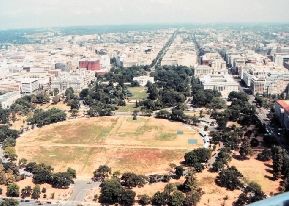
for so large an ellipse – nearly 17 acres – so that the question, "How was the Ellipse laid out?" is
of considerable interest. (The gardener’s method uses three stakes and a rope. Drive two stakes
into the ground, and let 2c be the distance between them. Each end of the rope, which must
be longer than 2c; is attached at the bottom of a …xed stake and then the third stake is used to
pull the rope tight. The third stake is then moved so that the rope remains tight and the stake
stays perpendicular to the ground, with the bottom of the stake pressed against the ground. The
path traced by the bottom of the moving stake is an ellipse. Its foci are marked by the stationary
stakes. The signi…cance of the number c is described in Section 3.)
    This article establishes that the Ellipse, practically speaking, really is an ellipse. Features, such
as eccentricity and location of foci, are considered, along with the striking but rarely recognized
placement of the Ellipse relative to a special axis determined by Charles L’Enfant and Thomas
Je¤erson. The Ellipse (boundary) is de…ned in [26] by the face of the inner curb of the driveway
shown in Figure 2. (Thus, the world’s largest ellipse may be the one determined by the outer curb
of the driveway.)

                     Figure 2. The walkway inside the Ellipse. The boundary of
                      the Ellipse is the inner curb of the driveway behind the trees.
                                        Photo by John E. Brown [4].

   The Ellipse was laid out during 1877-1880 by the Army Corps of Engineers, under the direction
of Thomas Lincoln Casey. In 1933, responsibility for the Ellipse passed to the National Park
Service. This article was made possible by NPS, and thanks are here given to Ann Bowman Smith
and David R. Krause, both of the NPS O¢ ce of White House Liaison. Special thanks also goes
to David R. Doyle of the National Geodetic Survey and John E. Brown, who visited the Ellipse,
con…rmed several features on the NPS survey [21], and took photographs [4], as in Figure 2.
2 Area and Perimeter
Quoting from [13], “This information was taken from the most recent survey of the Ellipse and
provided...by a sta¤ civil engineer.
major axis 1058:26 feet
minor axis 902:85 feet
area 751071:67 square feet
perimeter 3086:87 feet
All measurements were taken in microstation from face to face of the curb line.” Thus, with
reference to the standard form of equation for an ellipse,
x2 y 2
+ 2 = 1;
a2 b
the semimajor and semiminor axes of the Ellipse are given by a = 529:13 and b = 451:42: The
formula A = ab for the area of an ellipse yields a calculated area of 750400 square feet: Using the
measured values of a; b; and A; the di¤erence in areas is given by
100D
D 751071:67 750400 672; so that 0:09;
750400
an error of only 0:09%. This does not prove that the Ellipse is an ellipse, but that a …rst quick-
and-easy test has been passed.
Exact formulas for an elliptic perimeter are not in closed form, but in practice, formulas that
give a close approximation su¢ ce. The most common such formula gives
p
perimeter 2(a2 + b2 ) 3090;
so that the di¤erence between measured and calculated values is given by
100d
d = 3086:87 3090 3:1; so that 0:1;
3086:16
again, an error of less than one part per thousand. The Ellipse has passed a second test. Further
consideration is given in Section 5, but before that, we shall treat the Ellipse as su¢ ciently close
to a mathematical ellipse that we may speak of its foci, directrices, and other features.
3 Foci of the Ellipse
Thepfoci of the ellipse (x=a)2 + (y=b)2 = 1; where a b; are the points ( c; 0) and (c; 0) given
by c = a2 b2 : For the Ellipse,
p
c = (529:13)2 (451:42)2 276;
so that the distance between foci is 2c 552; and the eccentricity is
e = c=a 0:52:It is the eccentricity that tells the “shape” of an ellipse. If e = 0; the ellipse is a circle, and if
e = :99; the ellipse is much longer than wide. When e = 1 the curve is no longer an ellipse, but a
parabola, and when e > 1, the curve is a hyperbola. The cases e = 0 and e = 1 can be regarded
as extremes for ellipses, so that we may say loosely that the eccentricity of the Ellipse is half way
between the extremes.
Every ellipse has directrices, one associated with each focus. Let F denote the west focus of
the Ellipse, and let D denote the associated directrix. For any P on the Ellipse, the point-to-point
distance jP F j and the point-to-line distance jP Dj maintain a constant ratio as P moves around
the Ellipse. That constant is the eccentricity:
jP F j
= e = 0:52:
jP Dj
Taking P to be the west vertex of the Ellipse, and using values already calculated,
jP Dj = 0:52jP F j = 0:52(a c) 0:52(529 276) 131:5:
That is, the west directrix passes through President’s Park about 130 feet west of the west vertex,
and about half way to 17th Street. On the other side, the east directrix passes about half way
from the east vertex to 15th Street.
4 Center of the Ellipse
In Figure 3, you can see the Ellipse and, at its center, the notation BM 18. This image is
copied from one of those wonderful topographic maps published by the United States Geological
Survey. The USGS website has a contact link that was used to ask what BM 18 means. The
surprising answer was that it’s a benchmark but not one of ours...at …rst we didn’t know what it
was...turns out to belong to the National Geodetic Survey, and it has a name: the Meridian Stone.
Figure 3. Portion of a USGS
map [29]
To say that the location of the stone is well-documented is an understatement. Indeed, the
center of the little brass conical hole embedded in the granite has the following location:Latitude 38 530 38:1700200 North of the Equator
Longitude 77 020 11:5584500 West of Greenwich Meridian
Elevation 5:205 meters above sea level.
Relative to the center (of gravity) of the earth, this location is given in meters as a point in
cartesian coordinates:
(x; y; z) = (1115076:648; 4844021:259; 3983142:714):
To con…rm these data and …nd explanations, start by visiting the NGS (National Geodetic
Survey) website [16] for data sheets. That site explains various options for viewing data sheets
and o¤ers links to speci…c stations; including the station [17] designated as the Meridian Stone.
Internet images [18] and [19] of the Meridian Stone are easily found. However, despite its internet
presence, the Meridian Stone seems to be little known to NPS. For example, one of my former
students spent an hour at the Ellipse in August, 2003, and tried unsuccessfully to …nd the stone.
Moreover, the stone is not mentioned in lengthy reports ([22], [31]) written for NPS. Indeed, an
NGS surveyor wrote to me that in 1990, he and a surveyor friend “rediscovered” the Meridian
Stone...
Initially, our discussions with the Park Service indicated that they had no idea of what we
were talking about. They did agree however to assist us in a survey. On a very nice spring
Sunday morning, we set a theodolite over the Zero Milestone, backsighted the Washington
Monument, and using the computations from the positions we had in the National Spatial
Reference System, I computed the direction and distance to the Meridian Stone. I had Alan
keep me on line and using an electronic distance instrument, he put me at the computed distance.
I inserted a probe at the computed point and about 2 inches down I hit the mark. The
representative from the Park Service was amazed...
The Meridian Stone is located 0:607 meters (1:99 feet) from the north-south axis of the Ellipse.
This axis, with longitude 77 020 11:58362 W, is of historical interest, as President Thomas Je¤erson
once desired that there be an American prime meridian. He instructed Nicholas King, Surveyor of
the Federal District, to establish this Meridian as the north-south axis through the front door of the
President’s House. You can view King’s handwritten report to Je¤erson by following these steps:
…rst, access http://memory.loc.gov/ammem/mdbquery.html . Type Nicholas King in
the Search Box; scroll to item 9, and click the underlined tag, dated Oct. 15, 1804. Details about
this and other attempts to establish an American prime meridian are given by Silvio A. Bedini [1],
Historian Emeritus of The Smithsonian Institution.
The north-south axis of the Ellipse could be called the Je¤erson Axis, as it passes – at least,
cartographically –through the Je¤erson Memorial, although there seems to exist no o¢ cial state-
ment regarding the possible placement of the top of the dome of the Memorial right on the Je¤erson
Axis. Figure 4 shows the Je¤erson Memorial in line with the White House and the center of the
Ellipse.
The previously mentioned angles (latitude and longitude) and distance coordinates for the
Meridian Stone can be con…rmed using [20] to convert from one system to the other, and [28] to
compute surface distance between two user-input points given by latitude and longitude.
As a …nal consideration regarding the center of the Ellipse, one may speculate that the method
of layout may have been simply to start at the center, (0; 0); and to “send the chain man” out to
the point (x; y) for many choice of x, with y determined by the equation x2 =a2 + y 2 =b2 = 1; or,
equivalently, for many choices of angle ; to place a stake at the point (a cos ; b sin ):Figure 4. Aerial view [11] of The White House Grounds,
the Ellipse, and Washington Monument Grounds
5 Quadrarcs
In the literature of landscape architecture, possibly the most often cited example of an oval
that is often called an ellipse is the Piazza of St. Peter, or Piazza Obliqua, in front of St. Peter’s
Basilica.
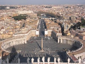
Figure 5. View [30] from the cupola of St. Peter’s
Basilica, Rome
Major axis: 650 ft. Area: 254306 sq ft. Perimeter 1815 ft,
of which 1815/4 ft measures each of the four circular arcs.Designed by Gianlorenzo Bernini some 300 years ago and based on sixteenth-century oval
constructions by Sebastiano Serlio, it is well known [10] that the Piazza employs four circular arcs,
as suggested by Figure 5.
Gridgeman [10] calls such four-circle ovals quadrarcs. The de…ning property of a quadrarc is
that at each point of intersection of the circles, the normals are identical. Equivalently, the circles
have a single point of intersection, called a joint, at which they share a common tangent line. Now,
two questions arise: (1) how closely can a quadrarc approximate an ellipse, and (2) was the Ellipse
laid out as a quadrarc? Let E(a; b) denote the ellipse x2 =a2 + y 2 =b2 = 1; where a > b: Following
Gridgeman, let h and k be distances as shown in Figure 6.
Figure 6. Ellipse and Quadrarc (drawn by The Geometer’s
Sketchpad )
The two circles are given by
x2 + (y + k)2 = (b + k)2 and (x h)2 + y 2 = (a h)2 :
Subtraction yields y = (2bk 2hx + b2 a2 + 2ah + 2bk)=2k. Using this to substitute for y in
either circle-equation and then solving for x gives a discriminant, D: The meeting of the circles in
a single point is equivalent to D = 0; which leads directly to the following dependence of k on h:
a b 2h + b a
k= ;
2 h+b aor, equivalently, (a b)(h + k) hk = (a b)2 =2; showing that h and k are interchangeable.
Moreover, the joint in the 1st quadrant is the point
h(a h)
P = (M; M k=(h k)); where M = h + p :
h2 + k 2
Table 1. Comparisons of quadrarcs Q(a; b; h) with ellipse E(a; b)
h(a; b) k(a; b) area, % error perimeter, % error
23:529 21:982 750400; 0 3071:3; 0:6
21:946 23:564 759660; 1:234 3090:1; 0
To interpret Table 1, note that in the …rst row of numbers, the percentage error in the area
of Q(a; b; h) and E(a; b) is zero because this is the condition from which k(a; b) is calculated from
h(a; b): When the areas of the two shapes are equal, the perimeter of Q(a; b; h) is 3071:3 feet, which
di¤ers from the perimeter of E(a; b) by an error of 0:6%: The other row shows that if k is chosen
to equalize the perimeters of Q(a; b; h) and E(a; b); then the error in area is 1:234%.
In Table 2, the quadrarcs of Table 1 are compared with the Ellipse in Washington, D.C.
Table 2. Comparisons of quadrarcs Q(a; b; h) with the Ellipse
h(a; b) k(a; b) area, % error perimeter, % error
23:529 21:982 750400; 0:01 3071:3; 0:39
21:946 23:564 759660; 1:1 3090:1; 0:1
The two tables indicate that the ellipse E(a; b); the Ellipse, and the two quadrarcs are so close
to one another that two conclusions follow: (1) the shape of the Ellipse is an ellipse (architecturally
speaking), and (2) measurements (and historical records, as we shall see in Section 6) are insu¢ cient
for deciding whether the Ellipse was laid out as a quadrarc. Regarding (1), it should be kept in
mind that the Ellipse is not perfectly ‡at and horizontal (see Section 6), and that no physical
object can be a true ellipse in the mathematical sense. This latter observation is a reminder that a
mathematical ellipse consists of in…nitely many non-physical stationary points, whereas a physical
ellipse consists of a …nite number of jiggling atoms. When we speak of a real-world “true ellipse,”
we mean a “curve“ that quali…es as a “true ellipse“ as these terms are understood in an appropriate
nonaxiomatic discipline, such as landscape architecture or astronomy. For example, in landscape
architecture, the Piazza Obliqua in Rome does not qualify as a “true ellipse.”
Curves other than quadrarcs have been used to approximate ellipses. Such curves, as well as
quadrarcs, are discussed by Rosin ([24], [25]).
6 Maps, Documents, and Historical Notes
Probably, the most detailed account of the history of the Ellipse is that given in the Zaitlevsky
Report [31], especially pages 4-29 to 4-36. The Zaitlevsky account has served as a guide for the
present account.
Prior to 1867, and for years thereafter, the elliptical area shown in [3], considerably smaller
than at present, was known as the White Lot. This area, leading down to Tyber Creek, had served
as a campground and in…rmary during the Civil War. By March 1867, Congress had transferred
responsibility for the White Lot to the Chief Engineer of the Army.In 1877, Thomas Lincoln Casey (1831-1896), then a Lieutenant-Colonel, was placed in charge
of the grounds. Casey [7] writes, in a paragraph on Grounds South of the Executive Mansion:
"The improvement of the southern portion...progresses very slowly; and consists mainly in grading
such soil, clay, and refuse material as may be deposited therein by contractors and others, who
…nd this a convenient dumping ground. To properly complete the grading ...would require a large
appropriation to purchase a su¢ cient quantity of soil..." A year later, under the same heading,
Casey writes,
This reservation, known as the White Lot, has been …lled to within about 3 feet
of grade, over a large portion of its surface, the sunken parts being along Seventeenth
street. A plan of improvement after the project of Downing and as approved by
President Fillmore was commenced during the year. It consists substantially of a large
…eld or parade some 17 acres in extent, and elliptical in shape, which will occupy the
center of the reservation... . The construction of the parade will be continued the
coming year.
Zaitlevsky [31, pp. 4-30] notes that Casey’s 1878 report [6] seems to be the …rst place where
the word ellipse appears. In his 1880 report, Casey [7] continues:
These grounds are being laid out in accordance with a general project for the im-
provement of the contiguous reservations south of Pennsylvania avenue, as designed by
A. T. Downing in 1851-’53. The main feature for this lot is an open elliptical …eld, cov-
ering some 17 acres in the center of the square, the borders of the square to be planted
thickly with trees and shrubbery. During the past year very satisfactory progress has
been made with this improvement, and the grading, soiling, and seeding of the central
ellipse has been completed, excepting a small area in its center, left by reason of an
incompleted sewer in charge of the District Commissioners. The large depression along
Seventeenth street was …lled to grade, mainly from the excavations of the cellar of the
north wing of the State, War, and Navy Departments building...
The total quantities of materials deposited in the lot during the year were as follows:
56,980 cubic years of earth; 9,053 cubic yards of soil; and 2,228 cubic years of gravel.
During the coming year it is expected to complete the grading, soiling, graveling, and
planting of the eastern half of the lot, giving to that portion something of a park-like
appearance.
The next annual report [23], written by Casey’s successor, states that “The ellipse now presents
an unbroken lawn surface. The total quantities of materials received and deposited during the year
were 18,943 cubic yards of earth, 7,225 cubic yards of soil, and 3,637 cubic yards of gravel...During
the coming year it is expected to complete the grading, soiling, graveling, and planting of the
western half of the grounds...”Figure 7. Map dated
September 29, 1877,
showing several signatures of
approval
A map entitled “Ellipse at White Lot” is signed “J. S. 6/9/82”. This map by John Stewart,
employed under Casey’s direction, includes measurements: margin, 30920 000 ; red line 4 feet out
from margin, 33160 400 ; green in center of drive, 32600 900 . This map, with scale 800 = one inch, is
kept in a vault in the Library of Congress.
Casey’s Annual Reports to Congress, cited above, do not reveal the manner in which the Ellipse
was laid out. In an e¤ort to learn the manner of layout, several archives were consulted, including
the O¢ ce of History of the U. S. Army Corps of Engineers, and the Society for Preservation of
New England Antiquities (SPNEA).
A historian at the O¢ ce of History wrote that the archival collection there does not have much
about Casey or the Ellipse. However, the O¢ ce does have a biographical sketch [27] of Casey, who
became Chief Engineer in 1888.
SPNEA has 72 manuscript boxes of Thomas Lincoln Casey Papers, with Accession number
MS 84-2160. These contain a great deal pertaining to Casey’s leading roles in the completion of
the Washington Monument and the design and building of the Library of Congress. However, a
lengthy search did not locate anything pertaining to the method of layout of the Ellipse.
Casey’s father, General Silas Casey, was a graduate of the U. S. Military Academy at West
Point, New York, which had been founded by Thomas Je¤erson in 1802. Thomas Lincoln Casey
graduated from West Point, …rst in the class of 1852. His son, also named Thomas Lincoln Casey,
graduated from West Point and became a renowned coleopterist.
7 Conclusions
There are two aspects of our knowledge about the Ellipse that leave much to be desired. One
is the apparent loss of records indicating how the Ellipse was laid out, and whether this layout was
undertaken after the extensive grading was completed. The other is the high level of precision ofthe four measurements stated in Section 2. Communications requesting clari…cation were subject
to security screening, and the recent NPS Survey [21] was obtained only after considerable security
checking and several months of waiting. The …nal communication states that the precise measure-
ments “were derived using the measuring tool in MicroStation V8, from an electronic compilation
of existing conditions computer generated survey …les. Locations of the minor and major axes, as
well as the perimeter delineation were estimated using these …les as a base.”
The measuring tool calculates area of a simple closed curve by approximating the curve as a
polygon; thus, both area and perimeter are easily calculated from measured lengths of straight
line segments, and the approximations are close if there are many well spaced points on the curve
selected as vertices of the polygon. For the Ellipse, these points were on the face of the inner curb
of the driveway. Unfortunately, the number of such points and information about their spacing was
not available, so that we are left to trust, on the basis of the remarkable precision of the reported
area (751071.67 square feet), that there were many such points and that the reported value really
is a close approximation of the actual area of the Ellipse. Note that the method just described
pertains to the plane curve determined by the curb, as suits our puposes in this article; in other
words, the slight internal “hilliness”indicated by many internal elevation marks on Survey [21] was
disregarded in the measurement of area.
One other feature of the Ellipse is that it is not horizontal, but lies on a slope from the White
House down to the level of the Potomac River. The elevations at the top of the granite curb at
the four vertices and near the center of the Ellipse are as shown here:
(north) 24:600
(west) 18:790 (center) 17:890 (east) 14:990
(south) 10:800
It is hoped that appropriate measurements will someday enable a closer examination of this
question: “How close is the Ellipse is to a mathematical ellipse?” A future researcher may wish to
know that “the most recent survey” cited in Section 2 may di¤er from the 2001 Survey [21]. The
latter consists of eleven 20 30 sheets (i.e., 66 square feet) with many details, but it does not show
the four measurements cited in Section 2.
References
[1] Silvio A. Bedini, The Je¤ erson Stone: Demarcation of the First Meridian of the United States,
Professional Surveyors Publishing Co., Inc., Frederick, Maryland, 1999.
[2] William Blackwell, Geometry in Architecture, John Wiley & Sons, New York, 1984.
[3] Albert Boschke, map, 1861, in Worth of the Nation: The History of Planning for the National
Capital, National Capital Planning Commission, Frederick Gutheim, Consultant, Smithsonian
Institution, 1977.
[4] John E. Brown, photographs taken at the Ellipse:
http://csserver.evansville.edu/~brownie/photos/ellipse2003/
[5] Thomas Lincoln Casey, Annual Report of the Chief of Engineers [for the …scal year ending
June 30, 1877], App. KK2, Government Printing O¢ ce.
[6] Thomas Lincoln Casey, Annual Report of the Chief of Engineers [for the …scal year ending
June 30, 1878], App. KK1, Government Printing O¢ ce.[7] Thomas Lincoln Casey, Annual Report of the Chief of Engineers [for the …scal year ending
June 30, 1880], App. NN1, Government Printing O¢ ce.
[8] David R. Doyle, “The Washington Monument Height Modernization Project,” Professional
Surveyor, January 2000, vol. 20, no. 1, 8-20.
[9] David R. Doyle, email to Clark Kimberling, March 26, 2003.
[10] N. T. Gridgeman, “Quadrarcs, St. Peter’s, and the Colosseum,”The Mathematics Teacher 63
(1970) 209-215.
[11] Historic American Buildings Survey photograph no. 649-2, Library of Congress.
[12] Timothy K. Kitao, Circle and Oval in the Square of Saint Peter’s: Bernini’s Art of Planning,
New York University Press, New York, 1974.
[13] David Krause, Archivist of NPS O¢ ce of White House Liaison, email to Clark Kimberling,
February 19, 2003.
[14] Map dated September 29, 1877, Library of Congress, Division of Maps,
G3852.W46 1877 .U5.
[15] National Oceanic and Atmospheric Administration (NOAA), Photo Library:
http://www.photolib.noaa.gov/htmls/geod0558.htm
[16] National Oceanic and Atmospheric Administration, datasheets,
http://www.ngs.noaa.gov/cgi-bin/datasheet.prl
[17] National Oceanic and Atmospheric Administration, link to datasheet for the Meridian Stone,
http://www.ngs.noaa.gov/cgi-bin/ds_desig.prl
[18] National Oceanic and Atmospheric Administration,
http://www.photolib.noaa.gov/htmls/geod0537.htm
[19] National Oceanic and Atmospheric Administration,
http://www.ngs.noaa.gov/INFO/Washmon/images/MERI.jpg
[20] National Oceanic and Atmospheric Administration,
http://www.ngs.noaa.gov/TOOLS/XYZ/xyz.html
[21] National Park Service, Existing Conditions Survey of the Ellipse, 2001.
[22] George J. Olszewski, The President’s Park South, Washington, D.C., O¢ ce of History and
Historic Architecture, Eastern Service Center, National Park Service, U. S. Department of the
Interior, April 1970.
[23] A. F. Rockwell, Colonel, U. S. Army, Annual Report [for the …scal year ending June 30, 1881],
Appendix RR, Government Printing O¢ ce.
[24] Paul L. Rosin, “A survey and comparison of traditional piecewise circular approximations to
the ellipse,” Computer Aided Geometric Design 16 (1999) 269-286.[25] Paul L. Rosin, “On Serlio’s constructions of ovals,” The Mathematical Intelligencer 23 (2001)
58-69.
[26] Ann Bowman Smith, Director, NPS O¢ ce of White House Liaison, letter to Clark Kimberling,
October 2, 2003.
[27] United States Army Corps of Engineers, O¢ ce of History,
http://www.usace.army.mil/History/Pages/Mission.aspx
[28] United States Department of Agriculture (former host), John A. Byers’ website, “Surface
Distance Between Two Points of Latitude and Longitude,”
http://www.chemical-ecology.net/java/lat-long.htm
[29] United States Geological Survey, Washington West Quadrangle, District of Columbia of Mary-
land - Virginia, 7.5 minute series, 1965, photorevised 1983.
[30] Virtual Tourist website:
http://www.virtualtourist.com/vt/23513/4/474/?o=3&i=1
[31] Cynthia Zaitslevsky (EDAW, Inc., Land and Community Associates, Cynthia Zaitzevsky &
Associates, John Milner Associates), President’s Park Cultural Landscape Report: Site His-
tory, Existing Conditions, Analysis, and Evaluation, prepared for The National Park Service,
Denver Service Center, May 1995.You can also read