The Structure of the Volcanic Lake in the Urbich Caldera (Iturup Island, the Kuril Islands)
←
→
Page content transcription
If your browser does not render page correctly, please read the page content below
IOP Conference Series: Earth and Environmental Science

PAPER • OPEN ACCESS

The Structure of the Volcanic Lake in the Urbich Caldera (Iturup Island,
the Kuril Islands)
To cite this article: D N Kozlov 2021 IOP Conf. Ser.: Earth Environ. Sci. 666 042024

View the article online for updates and enhancements.

                               This content was downloaded from IP address 46.4.80.155 on 11/07/2021 at 18:59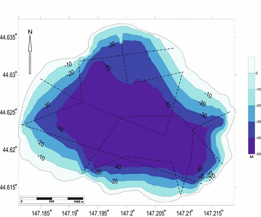
International science and technology conference "Earth science" IOP Publishing
IOP Conf. Series: Earth and Environmental Science 666 (2021) 042024 doi:10.1088/1755-1315/666/4/042024
The Structure of the Volcanic Lake in the Urbich Caldera
(Iturup Island, the Kuril Islands)
D N Kozlov1
1
Institute of Marine Geology and Geophysics Far Eastern Branch of the Russian
Academy of Sciences, 1 B, Nauka street, Yuzhno-Sakhalinsk, 693022, Russia
E-mail: kozlovdn@bk.ru
Abstract. The article presents and analyzes the original data on the morphological features and
the current state of a previously unexplored volcanic lake Krasivoe located in the Urbich caldera
(the Southern Kuriles). The bathymetric scheme and echolocation profiles obtained with using
of modern technique of digital bathymetric survey with satellite reference along the profile are
considered.
1. Introduction
Volcanic lakes of the world have been studied and described in detail in many works [1-13], some of
these works provide comprehensive information on the genetic or chemical classification of lakes, others
consider in detail the limnological features and important aspects of the functioning of lake ecosystems,
as well as the morphology of water bodies. Springer has published a very capacious work "Volcanic
Lakes" [14], which considers the issues of genetic and chemical classification of crater lakes, their
relationship with the geological setting, volcanism and post-volcanic processes. In Russia, volcanic
lakes are common inthe Kamchatka Peninsula and in the Kuril Islands. The state and morphology of
Kamchatka lakes is considered in works [15-19]. Some information about the Kuril lakes is contained
in the works [20-23]. However, in general, until the 2000s, the crater lakes of the Kuriles was remained
practically unexplored. Since 2005, Sakhalin volcanologists at the Institute of Marine Geology and
Geophysics (IMGiG FEB RAS) have been working on the study of these unique and hard-to-reach
objects using a modern high-precision echolocation survey technique with synchronous satellite
referencing of profiles [24-25]. In total, they surveyed 10 volcanic reservoirs, whilefor a long period of
time Krasivoe lake, located in the Urbich caldera, was overlooked in Iturup. In this regard, the tasks
were to set the survey and profiling of Krasivoe lake with the subsequent interpretation of the data
obtained.
2. Materials & methods
In 2014, a group of volcanologists from the IMGiG FEB RAS carried out comprehensive volcanological
studies in the island Iturup, one of the objects of research was the Urbich caldera, which is the central
structure of the volcanic complex Rocco. The relative age of the caldera is estimated as interglacial [26-
27], the diameter along the ridge is about 6 km, and about 9 km along the base. According to topographic
maps, the highest point of the caldera is Klinok mount with an absolute height of 745 m. The hard-to-
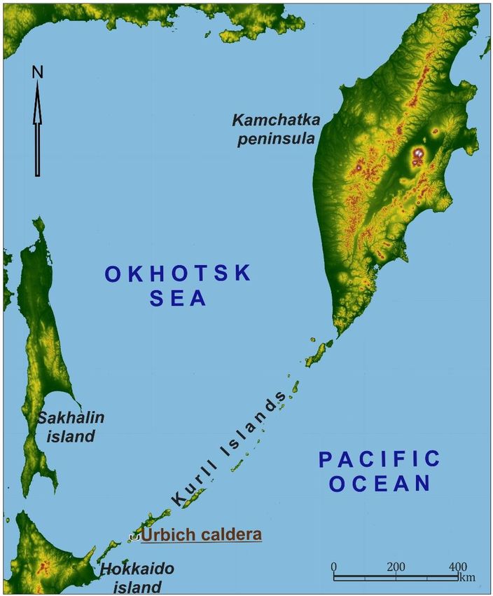
reach and poorly studied Krasivoe lake (44 ° 37'N, 147 ° 12'E) is located in the caldera (Fig. 1). The
relative height of the lake surface above sea level is 82 m, the catchment area is 38.3 km². By origin, it
Content from this work may be used under the terms of the Creative Commons Attribution 3.0 licence. Any further distribution
of this work must maintain attribution to the author(s) and the title of the work, journal citation and DOI.
Published under licence by IOP Publishing Ltd 1International science and technology conference "Earth science" IOP Publishing
IOP Conf. Series: Earth and Environmental Science 666 (2021) 042024 doi:10.1088/1755-1315/666/4/042024
belongs to the type of volcanic crater lakes, by the nature of water exchange, it is wastewater –there is
a channel in the southeast connecting the Pacific Ocean with the lake the Urumpet river, about 3.5 km
long. The age of the lake basin is presumably Late Pleistocene.
Figure 1. Location of the Urbich caldera and Krasivoe lake.
According to the available publications, it was established that the studies of Krasivoe lake were
carried out by employees of SakhTINRO, SakhNIRO and Kamchatka ichthyologists from
KamchatNIRO, who are engaged in the dynamics of salmon quantity [28]. They noted that the local
salmon population remain the least studied among other species of Pacific salmon of the Sakhalin
region; during these surveys, a detailed bathymetric survey of the reservoir was not carried out, in
connection with this we set the task of mapping and morphological description of the lake reservoir.
The study of the lake was carried out according to the previously approved technique [24-25] using
a Lowrance 527 CDF-iGPS echo sounder installed on an inflatable boat. The profiles were recorded at
a transmitter frequency of 200 kHz with a measurement step of 0.5 m and with synchronous satellite
referencing along the profile. In total, we obtained 10 profiles with a total length of 15 km; during their
processing, a sample of coordinates and depths was carried out, which amounted to about 17000
measurements. On the basis of these data, using the Surfer and Sonar Viewer programs, a bathymetric
scheme was built (Fig. 2) and digital echograms were described.
2International science and technology conference "Earth science" IOP Publishing
IOP Conf. Series: Earth and Environmental Science 666 (2021) 042024 doi:10.1088/1755-1315/666/4/042024
Figure 2. Composite bathymetric scheme of the Krasivoe lake.
3. Discussion and conclusion
As a result of work on Krasivoe lake, for the first time, we obtained important information about the
shape, size and specificity of the structure of the bottom of its basin:
1. Analysis of the converted bathymetric data and information from open geoinformation resources
(Google Earth and GeoMapApp) made it possible to describe the morphology of the lake basin and
calculate its main morphometric parameters. The maximum depth of the lake was 50 m, while the
average depth is 25.8 m, the volume of water mass reaches 0.15 km³, the length of the coastline is 9.35
km, and the surface area is 5.8 km². Detailed characteristics of the lake are given in the table of
morphometric parameters (table). The lake basin has a bowl-like shape without being complicated by
explosive funnels or underwater domes, the abrasive coastline has a pronounced scarp about 2-3 m
high.In the southern part of the basin, there are several bays 500-700 m long and a large bay 1350 m
long at its northern end.
2. It is likely that at present there is no gas-hydrothermal activity within the Krasnoye Lake, since
the presence of characteristic gas flares was not revealed on the echograms. This is confirmed by the
fact that the lake is inhabited by the largest population of sockeye salmon in the southern Kuril Islands
[28].
3. Based on the average sedimentation rate in the volcanic lakes of the South Kuril Islands of about
0.0009 m / year [29], taking into account the compaction of precipitation and wind drift, one can
calculate the thickness of the Holocene sedimentary cover in the lake 0.0009 m / year × 12000 years =
10.8 m. bottom sediments in the lake basin can be 70-75 m (0.0009 m / year × 80,000 years = 72 m),
and the total thickness, taking into account the sediments of catastrophic explosive eruptions of the
Lvinnaya Past caldera, is ~ 13000 and ~ 12,300 years ago. [30] - up to 80–90 m.
4. In some places of the lake, on the echo sounder profiles, inhomogeneities in the acoustic
permeability of bottom soils were noted. Such a hydroacoustic anomaly may be due to the presence of
effective reflectors at the bottom - massive fragments of volcanic rocks, compacted sediments or dikes.
3International science and technology conference "Earth science" IOP Publishing
IOP Conf. Series: Earth and Environmental Science 666 (2021) 042024 doi:10.1088/1755-1315/666/4/042024
Structural disturbances were also noted, complicating the relief of the sublittoral (possibly faults).
Krasivoe lake is a unique object located in the caldera of an extinct volcano and naturally filled with
atmospheric waters, which have formed a stable lake system in it. In the future, it is necessary to carry
out its comprehensive paleolimnological study and conduct a comparative analysis with similar objects
in the region and the world, this will allow us to determine its significant similarities and differences, as
well as get a clear idea of the history of development.
4. References
[1] Aeschbach-Hertig W, Hofer M, Schmid M et al. 2002 The physical structure and dynamics of a
deep, meromictic crater lake (Lac Pavin, France) Hydrobiologia Vol 487 pp 111-136
[2] Beck Chr, P Van Rensbergen, De Batist M et al. 2001 The Late Quaternary sedimentary infill of
Lake Annecy (northwestern Alps): an overview from two seismic-reflection surveys Journal of
Paleolimnology Vol 25 pp 149-161
[3] Brothers D S, Kent G M, Driscoll N W et al. 2009 New Constraints on Deformation, Slip Rate,
and Timing of the Most Recent Earthquake on the West Tahoe–Dollar Point Fault, Lake Tahoe
Basin, California Bulletin of the Seismological Society of America Vol 99 2A pp 499-519
[4] Diaconu D C, Mailat E 2010 Complex study of the lacustrian ecosystems of Mohoş Swamp Lakes,
reservoirs and ponds Vol 4(1) pp 70-78
[5] Huguen C, Foucher J P, Mascle J et al. 2009 Menes caldera, a highly active site of brine seepage
in the Eastern Mediterranean sea: «In situ» observations from the NAUTINIL expedition (2003)
Marine Geology Vol 261 pp 138-152
[6] Kazmierczak J, Kempe S 2006 Genuine modern analogues of Precambrian stromatolites from
caldera lakes of Niuafo‘ou Island, Tonga Naturwissenschaften Vol 93 pp 119-126
[7] Kazmierczak J, Kempe S, Kremer B et al. 2011 Hydrochemistry and microbialites of the alkaline
crater lake Alchichica, Mexico Facies Vol 57 pp 543-570
[8] Legesse D, Vallet-Coulomb Chr, Gasse F 2004 Analysis of the hydrological response of a tropical
terminal lake, Lake Abiyata (Main Ethiopian Rift Valley) to changes in climate and human
activities Hydrological processes Vol 18 p 487
[9] Moernaut J, Verschuren D, Charlet F et al. 2010 The seismic-stratigraphic record of lake-level
fluctuations in Lake Challa: Hydrological stability and change in equatorial East Africa over the
last 140 kyr Earth and Planetary Science Letters Vol 290 pp 214-223
[10] Morgan L A, Shanks P, Lovalvo D et al. 2003 The Floor of Yellowstone Lake is Anything but
Quiet! New Discoveries in Lake Mapping Yellowstone Science Vol 11 2 pp 15-30
[11] Rodriguez-Rodriguez M, Moreno-Ostos E, De Vicente I et al. 2004 Thermal structure and energy
budget in a small high mountain lake: La Caldera, Sierra Nevada, Spain New Zealand Journal of
Marine and Freshwater Research Vol 38 pp 879-894
[12] Takano B, Suzuki K, Sugimori K et al. 2004 Bathymetric and geochemical investigation of Kawah
Ijen Crater Lake, East Java, Indonesia Journal of Volcanology and Geothermal Research Vol 135
pp 299-329
[13] Tamura Y, Tani K, Ishizuka O et al. 2005 Are Arc Basalts Dry, Wet, or Both Evidence from the
Sumisu Caldera Volcano, Izu-Bonin Arc, Japan Journal of Petrology Vol 46 9 pp 1769-1803
[14] Rouwet D, Christenson B, Tassi F, Vandemeulebrouck J (eds) 2015 Volcanic Lakes Advances in
Volcanology (Springer) 533 p
[15] Bondarenko V I 1990 Seismoacoustic studies of Lake Kuril'skii Volcanology and seismology 4
pp 92-111 (In Russian)
[16] Ushakov S V, Fazlullin S M 1997 Morphometric studies of Lake Karymskoe Volcanology and
seismology 5 pp 132-141 (In Russian)
[17] Gavrilenko G M 2000 Hydrological model of the crater lake of Maly Semyachik volcano
(Kamchatka) Volcanology and seismology 6 pp 1-11 (In Russian)
[18] Gavrilenko G M, Gavrilenko P G 2003 Temporary crater lakes of the Mutnovsky volcano
(Kamchatka): the reasons for their formation and disappearance Bulletin of KRAUNTS. Earth
4International science and technology conference "Earth science" IOP Publishing
IOP Conf. Series: Earth and Environmental Science 666 (2021) 042024 doi:10.1088/1755-1315/666/4/042024
Sciences 2 pp 118-121
[19] Gavrilenko G M, Melnikov D V, Ovsyanikov A A 2009 The current state of a thermal lake in an
active crater of Gorely volcano (Kamchatka) Materials conf., Dedicated. To the 100th anniversary
of the expedition Ryabushinsky Petropavlovsk-Kamchatsky: IViS FEB RAS pp 86-95 (In
Russian)
[20] Zelenov K K, Kanakina M A 1962 Turquoise lake (Zavaritsky caldera) and changes in the
chemistry of its waters as a result of the 1957 eruption Bul. volcanol. station 32 pp 33-44 (In
Russian)
[21] Zotov A V, Sorokin V I, Nikitina I B 1988 Some features of modern hydrothermal activity in the
caldera of Golovnin volcano (Kunashir Island) Modern hydrotherms and mineral formation
(Moscow: Nauka) pp 54-68 (In Russian)
[22] Fazlullin S M, Batoyan V V 1989 Bottom sediments of the crater lake of Golovnin volcano
Volcanology and seismology 2 pp 44-55 (In Russian)
[23] Fedorchenko V I 1962 The main stages of the post-caldera period of the formation of Golovnin
Volcano (Kunashir Island) Tr. SakhKNII 12 pp 127-141 (In Russian)
[24] Kozlov D N 2015 Crater lakes of the Kuril Islands Yuzhno-Sakhalinsk: Sakhalin Regional
Museum of Local Lore IMGiG FEB RAS 112 p (In Russian)
[25] Kozlov D N, Zharkov R V 2009 New data on the morphology of intracaldera lakes of the Kunashir
and Simushir islands Bulletin of KRAUNTS. Earth sciences 2 14 pp 159-164 (In Russian)
[26] 1964 Geology of the USSR, Volume XXXI, Kamchatka, Kuril and Commander Islands Part 1:
Geological description (Moscow: Nedra) 733 p (In Russian)
[27] Fazlullin S M, Batoyan V V 1989 Bottom sediments of the crater lake of Golovnin volcano
Volcanology and seismology 2 pp 44-55 (In Russian)
[28] Bugaev V F, Kirichenko V E 2008 Feeding and spawning lakes of the Asian sockeye salmon
(including some other water bodies of the range) (Petropavlovsk-Kamchatsky: Kamchatpress
Publishing House) 280 p (In Russian)
[29] Razzhigaeva N G, Ganzei L A 2006 Sedimentation conditions of island territories in the
Pleistocene-Holocene (Vladivostok: Dalnauka) 247 p (In Russian)
[30] Degterev A V, Rybin A V, Arslanov Kh A and others 2016 Explosive eruptions on the island
Iturup in the Holocene: preliminary results of tephrochronological studies Monitoring. Science
and Technology 1(26) pp 7-11 (In Russian)
5You can also read