Monitoring of Historical Structures using Drones - IOPscience
←
→
Page content transcription
If your browser does not render page correctly, please read the page content below

IOP Conference Series: Materials Science and Engineering

PAPER • OPEN ACCESS

Monitoring of Historical Structures using Drones
To cite this article: Gulshan Taj et al 2020 IOP Conf. Ser.: Mater. Sci. Eng. 955 012008

View the article online for updates and enhancements.

                                This content was downloaded from IP address 46.4.80.155 on 14/12/2020 at 17:03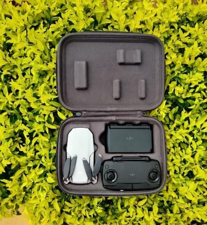
FIC-SISTEEM-2020                                                                           IOP Publishing
IOP Conf. Series: Materials Science and Engineering 955 (2020) 012008 doi:10.1088/1757-899X/955/1/012008

Monitoring of Historical Structures using Drones
                       MNA Gulshan Taj1, S Anand2, A Haneefi2, R P Kanishka2 and DHA Mythra2.
                      1
                          Associate Professor, Department of Civil Engineering, Sona College of
                      Technology. Salem, Tamil Nadu, India
                      2
                          Undergraduate Students, Department of Civil Engineering, Sona College of
                      Technology. Salem, Tamil Nadu, India

                      Abstract. The use of drones has been increased in recent years for surveying, facility
                      management and other relevant fields. However, more recently, the technological progress in
                      the design and navigation of low-weight and autonomous drones and UAVs have resulted in
                      their more practical and cost-effective operation in the fields of construction management and
                      monitoring. This study presents a framework for the development of a fully automated smart
                      construction monitoring and reporting system based on real-time data obtained from drones
                      and UAVs. The data in terms of drone images from multiple locations and point clouds (from
                      3D scanning of construction site) can be used to construct a 3D model using the
                      photogrammetry techniques. This so-called "drone model" can be compared to BIM model at
                      various construction stages to monitor the construction progress. Beside construction
                      scheduling and costing, this comparison can be expanded to include real-time recording,
                      reporting, billing, verification and planning. The system not only provides convenient and
                      smart ways of site supervision and management but also results in better monitoring operations
                      which are practically difficult by manual methods. The usability of this non-destructive
                      method of damage detection is shown with practical example.

1. Introduction

Civil Engineering not only deals with construction of structures but also more on monitoring and
maintenance of existing buildings [1]. An early detection of damages of cracks is required to avoid
accidents. Crack detection is not only for industrial and residential buildings, but also in the field of
monitoring of historical structures, which are in exposed conditions. Due to advancement in recent
technology, the usage of drones is rapidly increasing in various fields.

Drones permits remote data acquisition in environments dangerous to human life or inaccessible to
direct examination. The Drones provide potential for acquiring remote data more rapidly and at lower
cost than manual data collection [2]. Due to advancement in recent technology, the usage of drones is
rapidly increasing in various fields. In agriculture drones are introduced to know the status of their
agricultural land regarding crops health, crop monitoring. Certainly, the construction industry can take
the advantage of drone technologies in practical situation. Drones are used as a tool to visually
monitor their construction projects. The application of drone in examination of structures helps in
development of efficiency and quality of the structure.

              Content from this work may be used under the terms of the Creative Commons Attribution 3.0 licence. Any further distribution
              of this work must maintain attribution to the author(s) and the title of the work, journal citation and DOI.
Published under licence by IOP Publishing Ltd                          1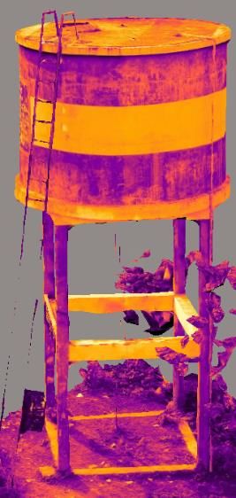
FIC-SISTEEM-2020                                                                           IOP Publishing
IOP Conf. Series: Materials Science and Engineering 955 (2020) 012008 doi:10.1088/1757-899X/955/1/012008

The Drone may be of various sizes, shapes, and structures (miniature unmanned helicopter, rotary-
wing UAV, quadcopter, drone, etc.) and they are qualified by their manifold characteristics.
Previously, they were ordinary aircrafts under remote control, but recently autonomous Drone have
been started to be used [3]. Modern Drone move according to the pre-programmed flight pathway or
they can be operated with the help of a more complicated system of dynamic automation. A digital,
calibrated, and integrated camera is installed in a Drone, the purpose of which is to acquire the Earth’s
surface photographic images. The images made during the Drone flights can be investigated and
processed by applying the methods of photogrammetry, with substantially lower costs to be incurred
than they used to be in cases, when the images were taken from an airplane equipped with the
complicated and rather expensive equipment, devices, and facilities [3].

Drones have become cheaper because many control functions can now be implemented in software
rather than having to depend on expensive hardware. This has allowed single or multiple Drones to be
employed for real-world applications. The Drones very often require a means of communication so
that they can communicate with on-land computers, sensors or other Drones. As most of the research
with Drones is still in its initial stages, there are a number of open questions that need solving, like
mapping and localization schemes, route planning, coordination and task allocation and
communication issues, among others [4]. Developed countries have already started use of Drones in
their precision agriculture, photogrammetry and remote sensing.

This paper deals with the use of drones for monitoring of structure that are difficult to access.

2. Visual monitoring of structures

2.1. Purpose of using drones for monitoring

Elevating platforms or scaffolding on structure are high-priced products and cause high logistical
efforts. Trained staff, like scaffolding, can get access to certain parts of the structure, but they can
hardly evaluate the damage on these structures with accuracy. Consequently, they can only take photos
or videos of the concerned part of the structures. Typically, visual monitoring of large structures like
dams, bridges towers, historical monuments or elements of those structures, needs particular
equipment’s and particularly trained staffs. Figure 1 shows structures that are hard to access and
monitoring unit like industrial climber.

                        Figure 1. Inspection of Tall structures with Man power

                                                     2
FIC-SISTEEM-2020                                                                           IOP Publishing
IOP Conf. Series: Materials Science and Engineering 955 (2020) 012008 doi:10.1088/1757-899X/955/1/012008

2.2. Drones - applications and limitations
Drones can fly remotely which is controlled by a pilot from surface. In civil engineering field light
weight drones are used, which has higher efficiency and are handy. These drones also can be provided
with higher-resolution camera or with other sensors, which provides various application in the field of
civil, agriculture, surveying, photography, disaster relief, meteorology and geology.
Agricultural application includes Agriculture land will be monitored by the drone from which the
images of the land will be acquired. Once the images are processed, they can be fed into the app portal
developed for the farmers. Through the portal farmer can know their complete 360 information about
their crop details including current market price. That will facilitate the farmer to make decisions to
combat any losses due to natural calamities.     Drones have some drawbacks, due to the small
payload, only light weight digital cameras can be used for photo and video capturing.

2.3. System configuration
The drone used here is DJI Mavic mini system made by SZ DJI Technology Co., Ltd., see Figure 2.

Table 1. Table with specifications of the drone

                             Specifications   DJI Mavic mini
                             Resolution       12 MP
                             Sensor           1/2.3” CMOS
                             Lens             Aperture: f/2.8
                                              Shooting Range: 1 m to ∞
                             Video            2 .7K at 30fps
                                              1080p at 60fps

                                       Figure 2. DJI Mavic mini

                                                    3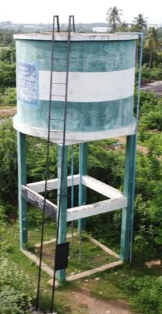
FIC-SISTEEM-2020                                                                           IOP Publishing
IOP Conf. Series: Materials Science and Engineering 955 (2020) 012008 doi:10.1088/1757-899X/955/1/012008

3. Case study

3.1. Visual inspection of Water tank

    Figure 3. Water tank                                 Figure 4. Flight path of drone

One of the important applications of drone is the visual inspection of structures like water tank,
religious structures, monuments, signal towers, etc. Since structural safety is important, the building
must be monitored visually; this monitorisation is done in short period, done by industrial climbers,
which is quite expensive and risky. Mostly, essential parts like columns and water tank head have to
be visually monitored. Manual inspection of those components constitutes a high risk for the
individual.

The water tank is located at sangeethapatty village, vetrilaikaranoor, kottagoundampatty post, omalur
taluk. The water tank was monitored thoroughly. Due to regular loading and unloading of water, the
main focus will on the column for the height of 10m and on the head of the tank. For data acquisition
of unknown structure, it is necessary to have efficient flight strategy priorly. For this, manual piloting
is suggested based on the wind speed, lighting conditions and obstacles around the building. Since the
restriction of flight time depends upon battery it is highly important to get adequate information about
the time to rise towards the head of the tank and return to home point, because the speed depends on
the flight mode chosen by the pilot.

Two flight strategies can be used for collecting data. These strategies can be designed priorly for a
GPS-based automatic flying and camera provoking. For strategy I the water tank was captured by
drone in predetermined path at fixed distance from the building and vertically predetermined level
from surface, while the drone camera is aligned towards the structure. The rate of camera capturing
can also be increased on the path, so that there is enough overlapping of the images during a post-
processing of images. The above concept of drone path is called point of interest (POI).

The hard part of the strategy I is that the drone pilot has to move along the drone for a continuous
connection and for the drone to be in vision. Moreover, the lighting and speed of wind changes on the
drone path around the water tank. Turbulences around the structures and irregular lighting will have

                                                     4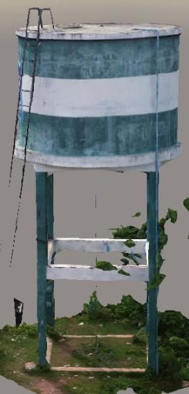
FIC-SISTEEM-2020                                                                           IOP Publishing
IOP Conf. Series: Materials Science and Engineering 955 (2020) 012008 doi:10.1088/1757-899X/955/1/012008

effects in the image quality. The main challenge was to get higher quality image for effective detection
of the crack. This allows identification of fine cracks, see Figure 5.

  Figure 5. 3D model of the water tank - visual colour (left) & thermal texture (right) – detection of
                             finite cracks in the wall of the water tank

4. Summary

This paper deals with the application of drone for monitoring of water tank without difficulty and
danger. The inspection and the results show the finite crack detected on the walls of the water tank. It
is economical when compared with other conventional inspection units.

These platforms can be flown near the structure and one can get very good images from the wall and
other inaccessible areas. The images, corrected and gathered can produce cartographic products
(orthomosaics) or 3D models, which have metric properties: this means that one can measure lengths
or can calculate areas. Then drone can also be used in other fields such as agriculture, survey etc.

5. Reference

[1]   Hallermann N and Morgenthal G 2013 Un-manned aerial vehicles (UAV) for the assessment
         of existing structures IABSE Symposium 2013 Report 266-267 Kolkata
[2]   Everaerts J 2008 The use of unmanned aerial vehicles (UAVs) for remote sensing and
         Mapping The International Archives of the Photogrammetry Remote Sensing and Spatial
         Information Sciences 37 (2008) pp 1187 - 92
[3]   Colomina I and Molina P 2014 Unmanned aerial systems for photogrammetry and remote

                                                    5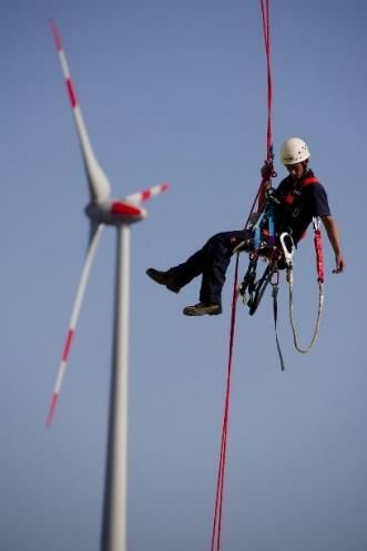
FIC-SISTEEM-2020                                                                           IOP Publishing
IOP Conf. Series: Materials Science and Engineering 955 (2020) 012008 doi:10.1088/1757-899X/955/1/012008

         sensing: A review ISPRS Journal of Photogrammetry and Remote Sensing 92 pp79-97
[4]   Bruno S Faiçal, Fausto G Costa, Gustavo Pessin, Jo Ueyama, Heitor Freitas, Alexandre
          Colombo, Pedro H Fini, Leandro Villas, Fernando S Osorio, Patricia A Vargas, Torsten
         Braun 2014 The use of unmanned aerial vehicles and wireless sensor networks for spraying
         pesticides Journal of Systems Architecture 60 2014 393–404
[5] C Eschmann, C m Kuo, C H Kuo and C Boller Unmanned aircraft systems for remote building
         inspection and monitoring, 6th European Workshop on Structural Health Monitoring Th.2.
          B.1
[6] F Remondino, L Barazzetti, F Nex and M Sarazzi 2011 UAV Photogrammetry for mapping and
          3d modelling – current status and future perspectives
[7] Youngib Ham, Kevin K Han, Jacob j Lin and Mani Golparvar Fard 2016 Visual monitoring
           of civil infrastructure systems via camera-equipped Unmanned Aerial Vehicles (UAVs): a
          review of related works
[8] https://www.molemaster.com/silo-cleaning-specialty-industrial-services/structural-silo-
inspection/
[9] https://www.centrocontrollomaterialiedili.it/en/2019/10/01/visual-inspection-bridges/
[10] https://www.dekra-solutions.com/2019/03/nose-in-the-wind/?lang=en

                                                    6
You can also read