DRONE ZONE AUSTRIA - Towards a Spatial Data Infrastructure for integrated risk based RPAS mission planning and UTM - Forschung
←
→
Page content transcription
If your browser does not render page correctly, please read the page content below
White Paper RPAS CIVOPS 2018 Paris                                                                  Paulus et al. 2018

DRONE ZONE AUSTRIA - Towards a Spatial Data
Infrastructure for integrated risk based RPAS mission
planning and UTM
Gernot Paulus1, Tamara Preduschnig1, Karl-Heinrich Anders1, Dariia Strelnikova1, Kurt A. Wagner2
1
 School of Geoinformation and Environmental Technologies, Carinthia University of Applied Sciences, Villach, Austria.
2
 Law & Consulting Offices of Kurt A. Wagner, P.C., Villach, Austria & Chicago, USA.
E-mail: paulus@cuas.at

Keywords: Unmanned Aerial Systems, UAS Regulations, SORA, Air Traffic Management, Mission Planning, Geofencing

Extended Abstract
The use of UAS at professional as well as recreational level has been risen tremendously in the last years.
The FAA expects “around 7 million drones flying over America in 2020” (http://www.popsci.com/new-faa-
reportstares-in-face-drone-filled-future ). Based on an estimation of the Austrian Aeroclub there have
been about 17,000 drones sold only for recreational use in 2015 in a small country like Austria. This
situation might cause an increased risk potential and high expected probability for incidences, especially
for urban areas.

There is not only in Austria an urgent need for awareness building due to the significant lack of
knowledge about legal requirements and drone mission regulations. Consequently, the need to create
awareness about legal issues for safe UAS operation and support for safe UAS mission planning is now
more relevant than ever before. This has been addressed recently with great effort by providing general
information     to   the     public.     Successful    examples       here     are     “KnowBeforeYouFly”
(http://knowbeforeyoufly.org/) in the US or “Drone Rules” (http://dronerules.eu/en/) for the EU.

There exist different approaches and attempts for the safe integration of UAS in the national airspaces
worldwide, but basically all UAS regulations follow a very similar risk-based paradigm. Here UAS mission
risk is defined as a function of Maximum Take-Off Weight (MTOW) and the characteristics of the area of
operation in terms of population density. Further requirements for the area of operation are the
presence of critical infrastructure, environmental protection sites and last, but not least, all general
aviation related and defined zones (e.g. Control Zones around airports, military danger zones, etc.).

Civil UAS aviation is currently dominated by VLOS operations below approximately 150m or 400 feet.
However, there is a strong need from industry (e.g. UAS Delivery, infrastructure inspection of
transmission lines or environmental monitoring of agriculture) for BLOS operation using advanced
autopilot systems with sophisticated navigation and high precision GNSS based positioning.

In its Circular Cir 328-AN/190 on Unmanned Aircraft Systems ICAO states in paragraph 1.7 “Unmanned
aircraft (UA) are, indeed, aircraft; therefore, existing SARPs apply to a very great extent. The complete
integration of UAS at aerodromes and in the various airspace classes will, however, necessitate the
development of UAS-specific SARPs to supplement those already existing.” (ICAO, 2011).

We argue that for any future UTM one key issue is the development of a new UAS-specific Standards and
Recommended Practice (SARP) focusing on the framework of defining areas of operation and geofences
based on high resolution geospatial data. Currently such a framework does not exist due to the fact that
general aviation did consider small scales (i.e. high detailed map representations) so far only in a very
limited manner around airports (e.g. aprons or obstacles in airport entry lanes). This represent a very
important difference between general aviation and UAS aviation data and is in our opinion also one of
the biggest challenges for any future UTM.

UAS mission planning is a very high resolution spatial task that needs high quality, accurate and up-to-
date situational awareness information about the area of operation in order to plan a rule compliant and
safe UAS mission. Currently, no solutions respectively tools providing all necessary information needed
for high resolution spatial UAS mission planning exist – neither in Austria nor on the international level.
White Paper RPAS CIVOPS 2018 Paris                                                       Paulus et al. 2018

At the moment each nation in the EU has either no or its own regulations for UAS below 150 kg maximum
take-off weight whereas EASA is responsible for airworthiness, certification and flight permissions for
UAS with more than 150 kg MTOW.

Currently a proposal by the European Aviation Safety Agency (EASA) A-NPA 2015-10 (EASA, 2015) for the
introduction of a regulatory framework for the operation of drones representing an EU-wide regulation
framework for UAS for weight classes below 150 kg is in discussion. In this EASA announcement different
areas of operation depending on the population density (e.g. “City Center”), no or limited drone zones are
proposed (Fig. 1) and shall be implemented as “Geofences”. A geofence in this context represents the
demarcation of a physical area and can be expressed in machine-readable form by coordinates.

           Fig. 1: Proposed EASA ‘no-drone zones’ and ‘limited-drone zones’ map (EASA 2015).

As an EU national example for legal UAS operation and integration in the national airspace, in Austria 4
areas of operation are defined in a risk-based approach. These areas of operation depend on the building
and population density as (I) undeveloped, (II) uninhabited, (III) populated and (IV) densely populated
since 2014 (Fig. 2). These areas of operation are described only in narrative form, but no spatial map-
based delineation are provided (LFG, 2013; LFG, 2016). Here the boundaries of the operational zones are
of special interest as UAS platforms are certified for specific operational areas as stated in individual
legal issued UAS operation approvals. Violation of such an approval may result in fines up to 22,000€.

                      Fig. 2: Categorization for operating UAS in Austria (LFG 2013)

Therefore we see a strong need for a scientific-based extraction and trusted map representation of such
risk related operational zones. Furthermore, commonly used data sources like Google Maps, Google Earth
or Bing Maps have no legal reliability and actuality, but are used very often as main base spatial
information for UAS mission planning.

                                                                                                          2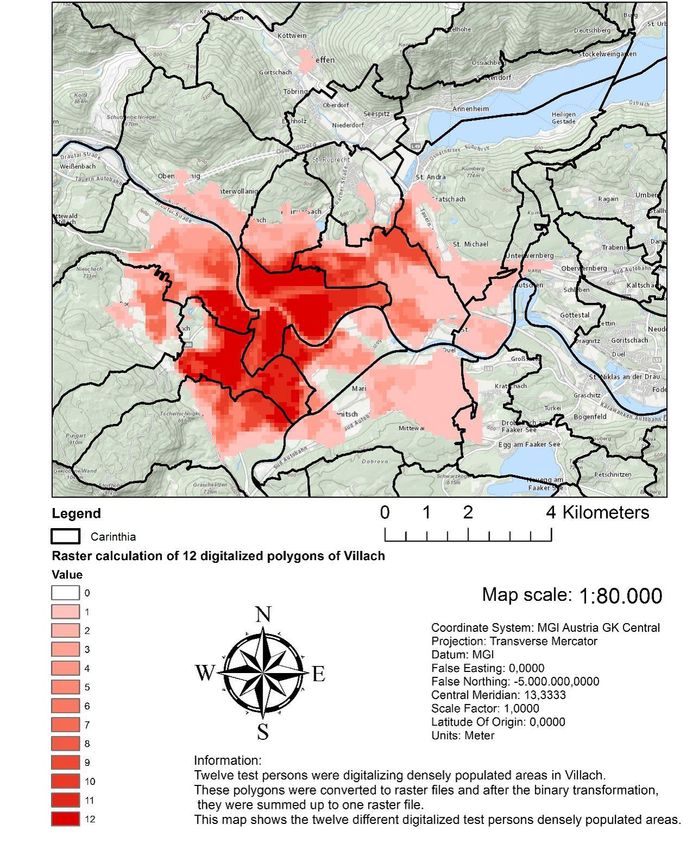
White Paper RPAS CIVOPS 2018 Paris Paulus et al. 2018
We currently investigate in the exploratory project “Drone Zone Austria” the design of a web portal
prototype as innovative contribution to air traffic management in order to support safe Unmanned Aerial
System (UAS, also known as Remotely Piloted Aircraft Systems (RPAS) or “Drones”) mission planning. One
unique and key feature of this web portal is a national wide map-based representation of the legally
defined 4 areas of operation for professional and recreational drone missions in Austria based on
building density.
An important goal of this project is the integration of UAS-relevant aviation information as listed in the
Aeronautical Information Package (AIP; “Luftfahrthandbuch Österreich”; AIP 2017). We are currently in
the process of defining aviation data relevant for supporting UAS mission planning in close collaboration
with aviation domain experts.
The key foundation of the web portal is a geospatial “Drone Zone Model” derived from available and up-
to-date high quality “trusted” geodata sources (e.g. address locations, road network, airport control zones,
danger areas). These data are provided by the Austrian public administration and the Austrian Aviation
Control as a result of the Open Government Data Initiative and the European INSPIRE Geodata
Infrastructure directive (Paulus et al. 2017a; Paulus et al. 2017b).
In order to demonstrate the ambiguity and real world consequences of the narrative definition of UAS
operational zones based on settlement density we have used different high resolution geodata sources for
the “simple” representation of buildings for the City of Villach in Austria. Based on this geodata we have
used different geospatial analysis techniques to derive representation for building density which can be
used as indicator for settlement density or population density. Different zones of building density and
therefore different “areas of UAS operation” result from the choice of geodata source and the selected
geospatial analysis method. Fig. 3 represent the building density based on georeferenced address point
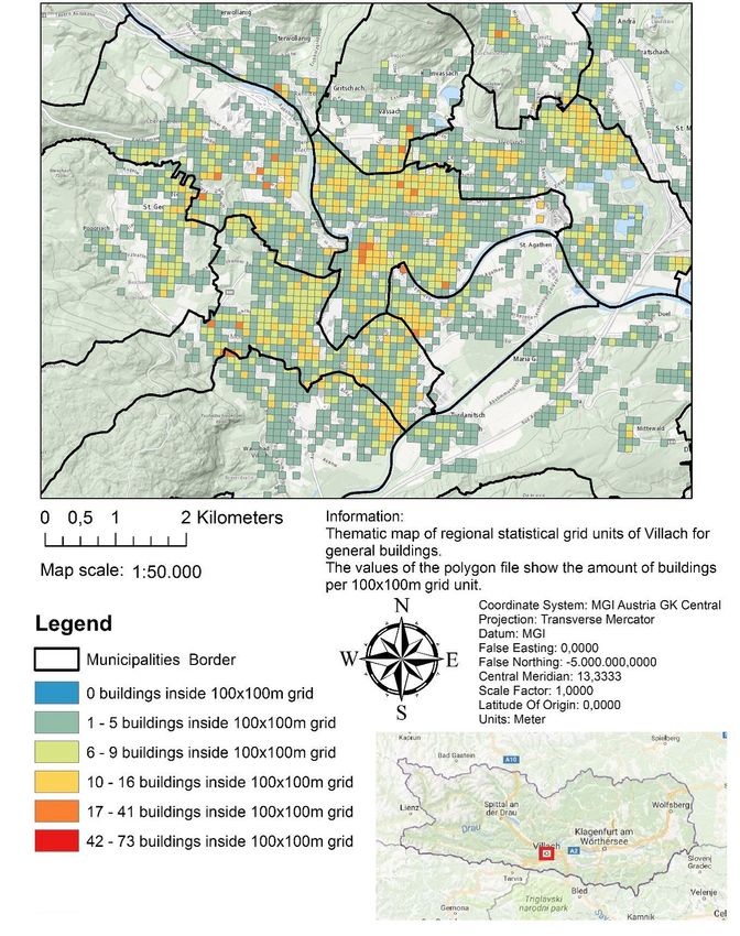
locations. Fig. 4 shows the distribution of the number of buildings per regional statistical units (i.e. 100m
x 100m). In order to evaluate the area of a building in contrast to an address-based point location, we
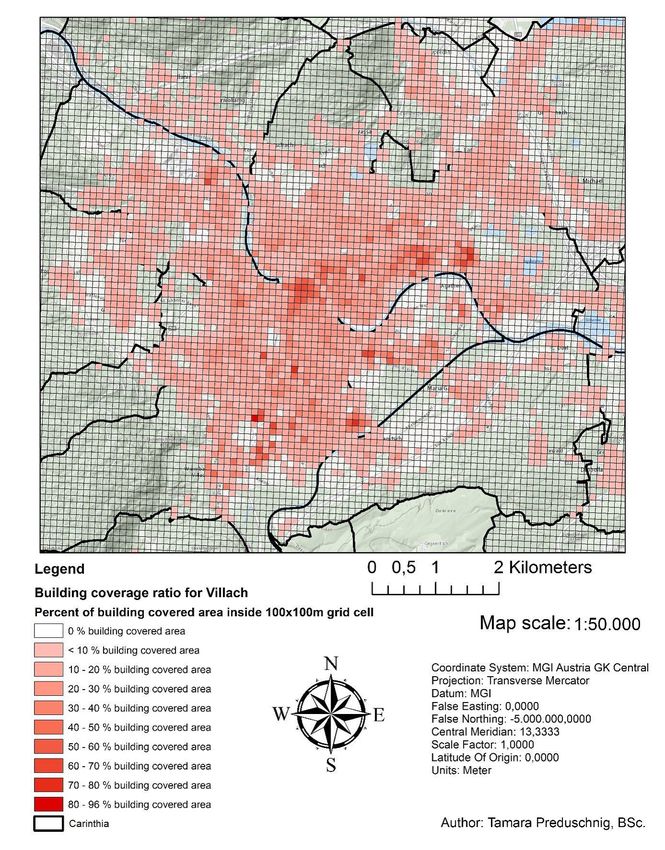
have calculated the building coverage ratio per ha using areal building footprint representations (Fig.5).
Finally, the individual perception of spatial representation play also a crucial role in spatial planning in
general. Such highly individualized perceptions of space are known as “Mental maps”. In an experiment
we have asked students to demarcate as polygon on an aerial image representing the city of Villach the
city center and/or highly populated areas using in Geographic Information System (GIS) (Fig. 6).
We have now developed as a proof-of-concept the web portal “Drone Zone Austria”
(www.dronezoneaustria.at) as a first fundamental step to support a holistic risk based drone mission
planning approach. “Drone Zone Austria” integrates for the first time 3 key spatial data sources for whole
Austria, i.e. (1) a nation- wide high resolution building/population density information representing the
legally required areas of operation derived by a transparent spatial analysis procedure and cartographic
representation; (2) relevant aeronautical information provided by Austrian Aviation Control authority
and (3) environmental protected sites. Furthermore, a base functionality for selecting the individual
flight permission category and then showing the relevant map-based drone mission restriction zone
information for the selected category is provided. Finally, all relevant spatial background information
like high resolution orthoimages or building footprints are provided by Geoweb Service integration of
basemap.at. Basemap.at is a high-performance web basemap published under an OpenGovernmentData
(OGD) license. It is based upon data provided by the nine Austrian provinces and their partners. Figure 7
provides an impression of the web portal “DroneZone Austria”. We are currently in the final
development and prototype testing phase. The portal will be publically available in QI/2018.
3
White Paper RPAS CIVOPS 2018 Paris                                                              Paulus et al. 2018

                 Fig. 3: Address Point Density distribution for the City of Villach, Austria.

                                                                                                                 4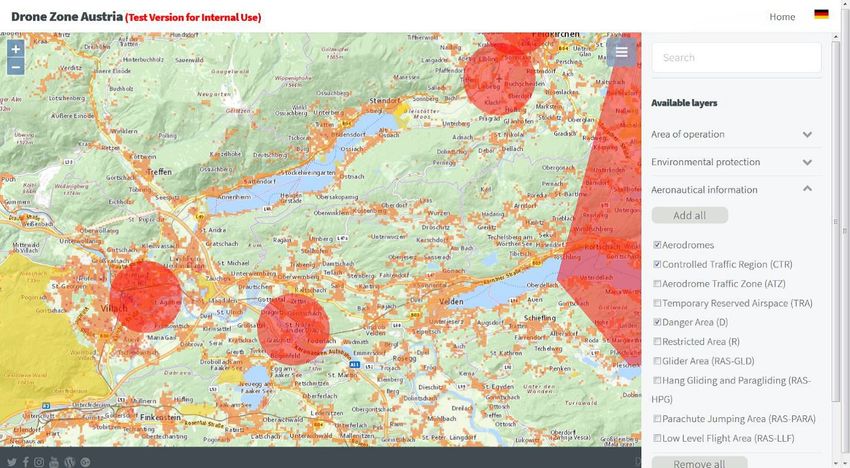
White Paper RPAS CIVOPS 2018 Paris                                                          Paulus et al. 2018

  Fig. 4: Number of buildings per regional statistical unit (100m x 100m) for the City of Villach, Austria.
                         White Paper RPAS CIVOPS 2018 Paris Paulus et al. 2018

                                                                                                              5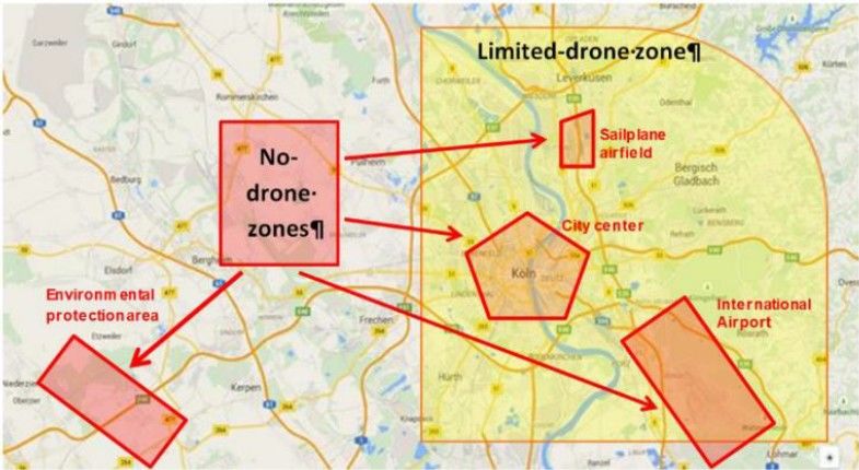
White Paper RPAS CIVOPS 2018 Paris                                                         Paulus et al. 2018

 Fig. 5: Building coverage ratio (Building area per ha) for the City of Villach (Austria). White Paper RPAS
                                    CIVOPS 2018 Paris Paulus et al. 2018

                                                                                                              6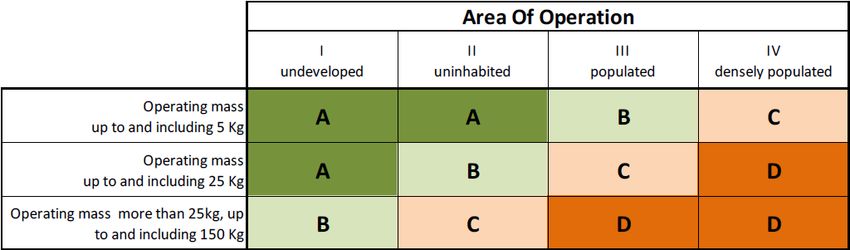
White Paper RPAS CIVOPS 2018 Paris                                                      Paulus et al. 2018

  Fig. 6: “Mental Map” experiment representing the different individual spatial perceptions of “densely
                   populated areas” or the “city center” for the city of Villach (Austria).

                                                                                                          7
White Paper RPAS CIVOPS 2018 Paris Paulus et al. 2018
Fig. 7: Proof-of concept web portal prototype “Drone Zone Austria”.
The high variation in a zone-based spatial settlement density representation show very clearly
complexity and its huge impact for UAS operators and UAS mission planning. Our results provide a clear
indication for the urgent need of a UAS-specific Standards and Recommended Practice (SARP) for the
definition, demarcation and provision of any UAS aviation relevant zone in Europe fully supporting a risk
based mission assessment in machine readable form. Another important issue in this context is the
clarification of “who” will be responsible to provide such trusted, validated and legally approved spatial
information?
Quite a significant number of “Smartphone Apps” have been published recently by various aviation
control authorities in Europe promising comprehensive information and support for drone mission
planning. Up to now, these “Smartphone Apps” mainly focus on aviation related standard information at
different scales, but do not provide key information like population and infrastructure relevant density
indicators for mission risk assessment.
In order to facilitate safe and legally compliant UAS risk-based mission planning, a spatial data
infrastructure is necessary for national aviation authorities and UAS operators as well. Current existing
spatial data infrastructures like the INSPIRE initiative (Infrastructure for Spatial information in the EU;
http://inspire.ec.europa.eu/) for the EU or the Open Government Data Initiatives (Attard et al., 2015)
provide here promising opportunities and a framework for utilizing high quality geodata for risk-based
UAS mission planning.
Acknowledgements
We highly appreciate the input of aviation experts Florian Glatzl, Gerhard Lippitsch and Klaus Gäbler
from Austro Control. The input regarding aviation relevant information for drone mission planning has
been provided on base of a third party contract within the “Drone Zone Austria” research project. The
exploratory project “Drone Zone Austria” has received funding from the Austrian research funding
programme “Take Off”. Take Off is a Research, Technology and Innovation Funding Program of the
Austrian Federal Ministry for Transport, Innovation and Technology (BMVIT). The Austrian Research
Promotion Agency (FFG) has been authorised for the Program Management.
Literature
AIP (2017). Aeronautical Information Publication Austria – Luftfahrthandbuch Österreich.
https://www.austrocontrol.at/flugsicherung/aim_services/aim_produkte/aip_und_sup. Last access:
23.04.2017
8White Paper RPAS CIVOPS 2018 Paris Paulus et al. 2018
Attard, J., Orlandi, F., Scerri, S. and S. Auer (2015). A systematic review of open government data
initiatives. Government Information Quarterly, Volume 32, Issue 4, 2015, pp. 399-418, ISSN 0740-
624X, http://dx.doi.org/10.1016/j.giq.2015.07.006
Federal Aviation Administration (2016). FAA Aerospace Forecast: Fiscal Years 2017-2037. Retrieved from
https://www.faa.gov/data_research/aviation/aerospace_forecasts/media/FY2017-
37_FAA_Aerospace_Forecast.pdf. Last access: 27.01.2018
EASA (2015). A-NPA 2015-10: Introduction of a regulatory framework for the operation of drones.
https://easa.europa.eu/document-library/notices-of-proposed-amendment/npa-2015-10. Last access:
23.02.2016
ICAO (2011). Unmanned Aircraft Systems (UAS) CIR328, ISBN 978-92-9231-751-5.
https://www.icao.int/Meetings/UAS/Documents/Circular%20328_en.pdf. Last access: 15.06.2017.
LFG (2013). Novelle zum Luftfahrtgesetz (108. Bundesgesetz: Änderung des Luftfahrtgesetzes (NR: GP
XXIV RV 2299 AB 2349 S. 203. BR: AB 8984 S. 821.).
LFG (2016). Bundesrecht konsolidiert: Gesamte Rechtsvorschrift für Luftfahrtgesetz.
https://www.ris.bka.gv.at/GeltendeFassung.wxe?
Abfrage=Bundesnormen&Gesetzesnummer=10011306Last access: 16.02.2016
Paulus, G., Preduschnig, T., Anders, K.-H., Gäbler, K., Glatzl. F., Lippitsch, G. and K. Wagner (2017a).
DRONE ZONE AUSTRIA - Development of a Web Portal for Safe Drone Mission Planning.
Proceedings RPAS Conference 2017, Brussels, Belgium - 13 & 14 June 2017.
Paulus, G., Preduschnig, T., Anders, K.-H., Gäbler, K., Glatzl. F., Lippitsch, G. and K. Wagner (2017b).
Drone Zone Austria ‒ Design of a Web Portal for Safe Drone Mission Planning in Austria. AGIT –
Journal für Angewandte Geoinformatik 3-2017, pp. 163-165.
9You can also read