Technology Nowcasting of Dangerous Weather Phenomena
←
→
Page content transcription
If your browser does not render page correctly, please read the page content below
IOP Conference Series: Earth and Environmental Science

PAPER • OPEN ACCESS

Technology Nowcasting of Dangerous Weather Phenomena
To cite this article: V A Shapovalov 2019 IOP Conf. Ser.: Earth Environ. Sci. 272 032031

View the article online for updates and enhancements.

                               This content was downloaded from IP address 46.4.80.155 on 12/05/2021 at 01:21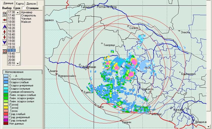
International science and technology conference "Earth science"                                                IOP Publishing
IOP Conf. Series: Earth and Environmental Science 272 (2019) 032031                        doi:10.1088/1755-1315/272/3/032031

Technology Nowcasting of Dangerous Weather Phenomena

                     V A Shapovalov1
                     1
                     Department of cloud physics, High-Mountain geophysical institute, 2 Lenin Ave.,
                     Nalchik, 360030, Russia

                     E-mail: atajuk@mail.ru

                     Abstract. The paper presents the developed elements of the system nowcasting hazardous
                     weather events in the North Caucasus. The approach is based on complex analysis and
                     extrapolation of instrumental observations data (weather radar, lightning detection network,
                     weather stations, satellite information) and numerical modeling data based on the mesoscale
                     model of the atmosphere. For the detection and warning of dangerous fast-growing convective
                     processes developed automated working place of acceptance, a comprehensive analysis and
                     display of radar, lightning detection, satellite and ground weather information. The system
                     allows you to monitor individual convective cells, determine the speed and direction of their
                     movement, the trend of their development. The evolution of convective cells is also predicted
                     on the basis of calculations based on a three-dimensional numerical model with detailed
                     microphysics. Keywords: nowcasting, thunderstorms, hail, radar data, numerical model.

1. Introduction
The problem of reducing the risk of emergencies caused by particularly dangerous natural phenomena
(downpours, thunderstorms and hail) is quite urgent, both for our country and abroad. The safety of
human life and protection of various objects from the effects of natural phenomena is largely
determined by the timely detection of the location of the dangerous phenomenon and the control of its
state. Of great importance for the detection and identification of natural hazards and measures of
protection against them have early warning systems based on remote sensing of the cloudy
atmosphere. In particular, widespread all over the world gets mesoscale technology - nowcasting [1-4].
It is a technology for collecting, processing, transmitting and ultra-short-term forecasting with 0-3
hours of real-time current weather information in advance.
    Currently, the implementation of forecasts for a very short time is based on a wide range of
information: ground, radar, satellite, numerical modeling. These are automatic weather stations, which
transmit data on pressure, temperature, humidity, wind speed and direction (with averaging from
several seconds to several minutes), radar measurements. In addition, the system includes the
organization of continuous data streams, assimilation of these data by numerical models with high
spatial resolution.
    As one of them quickly used of these systems can be noted a system of quick updates (Rapid
Refresh, RAP). It is an operational hourly assimilation / modelling system adopted by the US National
centers for environmental prediction (NCEP). It consists mainly of a 13 km numerical weather
prediction model (installed over North America) and an analysis/assimilation system to initialize the
model. RAP is complemented by a model with higher resolution (3 km) and fast update (High-
Resolution Rapid Refresh, HRRR). It also updates the data hourly, but covers a smaller area [5]. The
              Content from this work may be used under the terms of the Creative Commons Attribution 3.0 licence. Any further distribution
              of this work must maintain attribution to the author(s) and the title of the work, journal citation and DOI.
Published under licence by IOP Publishing Ltd                          1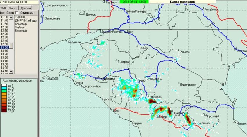
International science and technology conference "Earth science" IOP Publishing
IOP Conf. Series: Earth and Environmental Science 272 (2019) 032031 doi:10.1088/1755-1315/272/3/032031
RAP system is developed to provide users who need ultra-short-term weather forecasts with the ability
to quickly adjust, for example, for aviation [6].
In our country begin work on the creation of systems of nowcasting, they are in a stage of
development. For example, the Hydrometeorological center (Moscow) in 2017 began to create highly
accurate short-term forecasts - nowcasting. They give an idea of the weather in a particular area for a
few hours, but are able to track the movement of each cloud. Accurate weather forecast is needed not
only for people, but also for the economy.
The aim of this work was to develop a software system nowcasting hazardous weather events in the
North Caucasus. The approach is based on complex analysis and extrapolation of instrumental
observations data (meteorological radar, ground-moving network, weather stations, satellite
information) and numerical modeling data based on the mesoscale model of the atmosphere.
2. Comprehensive analysis and display of meteorological information
Currently, information systems are widely implemented in radiometeorology, whose tasks include
combining the results of observations of several meteorological radars (WR) with intersecting areas of
space survey [7]. Such consolidation of information of several WR allows to receive the uniform
complex radar map of the region (or the whole country) which informativeness is much higher, than
from separate radars. The total for the time interval maps of hazards allow us to estimate the total area
exposed to hydro-meteorological processes.
In order to detect and warn about dangerous fast-developing convective processes in the territory of
the North Caucasus, an automated workplace (AWP) of reception, complex analysis and display of
radar, lightning, satellite and ground (automatic weather stations) meteorological information was
developed at the High-Mountain geophysical Institute [8-10]. This paper presents a description of the
software, methods and algorithms for processing data of remote sensing of the atmosphere.
Meteorological information on the AWP comes through communication channels from weather
radar MRL-5 [11], new Doppler radars DMRL-C [12], lightning detection system LS8000 [13],
automatic weather stations and other sources. Recognition thunderclouds carried radar methods based
on the data of lightning detection [10,11,14]. The algorithms of the current forecast of meteorological
phenomena dynamics are based on approximation and extrapolation of data, and on formalization of
regularities obtained in the study of convective processes [9].
The author has developed an applied software and mathematical software that performs the
following functions: receiving data; mapping the spatial structure of the fields of clouds, precipitation
and thunderstorms on the background of the terrain map; mapping the dangerous weather phenomena
(storm precipitation, thunderstorms) on the background of the map of the administrative boundaries of
the region; analysis of the evolution of cloud structures, the direction and speed of moving clouds,
cloud systems and weather hazards.
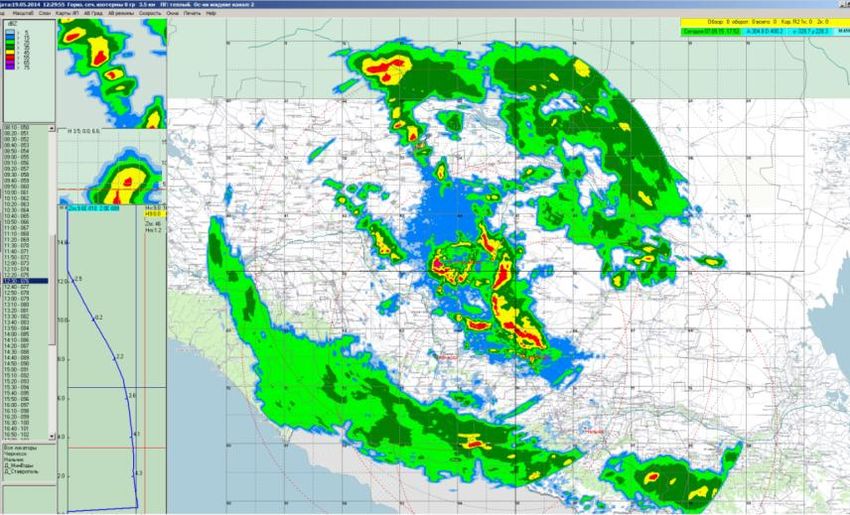
Examples of maps of storm broadcasting in the North Caucasus are presented in figures 1 – 3.
Figure 1 shows the cross-linking of radar information from several MPL in 10 minutes time interval
with high resolution ( 250m ), which is provided by modern radars.
Figure 2 shows the distribution of lightning discharges in the North Caucasus over a 10-minute
time interval according to the LS8000 lightning detection system. On the left, figure 2 shows a color
palette - the interval of the number of bits in the storm clouds during observation.
The developed software allows to perform combination of radar, lightning and satellite data.
2International science and technology conference "Earth science" IOP Publishing
IOP Conf. Series: Earth and Environmental Science 272 (2019) 032031 doi:10.1088/1755-1315/272/3/032031
Figure 1. Combined map of radio echo of clouds in the North
Caucasus from several WR (2016).
Figure 2. Display of thunderstorms (intra-cloud and cloud-to-ground) for
10 min interval on the territory of the North Caucasus (2013). The scale of
gradations corresponds to the number of digits per 1 km2.
The developed program is designed to form a single composite maps of weather phenomena on a
regional scale (figure 3). The figure shows the identified weather phenomena according to several
SCLC and lightning detection system. The circles represent the radius of the individual weather radar.
The program uses algorithms and criteria for recognition of dangerous convective processes from
[11,14].
System nowcasting severe weather allows you to keep track of individual convective cells in the
Northern Caucasus, to determine the speed and direction of their movement, the trend of their
development (strengthening or weakening).
However, in the processing of information of different remote sensing of the atmosphere there is a
problem associated with different spatial and temporal scales of measurement data. It can be overcome
by using numerical modeling [15], which is able to process these data (select approximating functions)
and move to uniform grids in time and space. The use of numerical models will contribute not only to
improving the reliability of the dangerous weather phenomena forecasting, but also to assessing the
degree of their danger (alleged damage). The effectiveness of the models for these purposes can be
enhanced through the implementation of parallel calculations of parameters of atmosphere and clouds.
3International science and technology conference "Earth science" IOP Publishing
IOP Conf. Series: Earth and Environmental Science 272 (2019) 032031 doi:10.1088/1755-1315/272/3/032031
Based on the results of numerical modeling [16,17], three-dimensional radar images of clouds are
already in good agreement with observations at this stage of model development. Three-dimensional
visualization of convective cloud parameters [18] makes it possible to interpret numerical data in a
natural form, coinciding with the actual volume data of the DMRL-C and the lightning detection
system, it significantly improves the capabilities of data analysis and decision-making.
Figure 3. A comprehensive map of weather phenomena on the territory of
the southern Federal district and the North Caucasus.
In the algorithm of tracking convective cells laid processing of the following options [19]: the
emergence of a new object; matching traceable object; separation of the object; merging objects;
disappearance of the object.
Figure 4 shows two cells observed by the radar at successive moments of time with an interval of
3.5 min. horizontally, three images are combined, in which two convective cells are depicted. Between
fragments (t2) and (t) the time interval is 7 min. Observed in the United drawings, the upper cell
develops, the bottom cell collapses. The arrows indicate the direction of displacement of the
convective cells.
Figure 4. Mapping of objects in a deterministic
tracking.
4International science and technology conference "Earth science" IOP Publishing
IOP Conf. Series: Earth and Environmental Science 272 (2019) 032031 doi:10.1088/1755-1315/272/3/032031
Technology nowcasting dangerous weather phenomena allows to increase the reliability of
warnings on hazardous hydrometeorological processes at the expense of complex processing of
continuously incoming information and the results of numerical simulation.
Thus, the paper presents a tried and tested elements of the system nowcasting hazardous weather
events in the North Caucasus.
3. Conclusion
In the context of increasing the frequency of natural phenomena and disasters, humanity must improve
methods and means to ensure safe living conditions.
Has been developed and is pilot testing three-dimensional non-stationary numerical model of a
convective cloud with detailed description of thermo-hydro-dynamic, microphysical and electrical
processes.
Developed software combining radar and lightning detection information, which is highly efficient
for the identification of hazardous weather events through the use of in addition to radar, more
information on lightning discharges with lightning detection system and satellite data. The software is
used in storm warning centers and paramilitary services to generate composite maps of weather
hazards across the North Caucasus region.
Developed elements of a modern system of nowcasting hazardous weather events in the North
Caucasus.
The developed software tools make it possible to alert and prepare in advance the special services,
the population and economic facilities to prevent damage from approaching powerful thunderstorms
clouds.
4. References
[1] Kohn M, Galanti E, Price C, Lagouvardos K and Kotroni V 2010 Now-casting thunderstorms in
the Mediterranean region using lightning data. Atmos. Res. 100 489–502
[2] Hagelin S, Auger A, Brovelli P, Dupont O 2014 Nowcasting with the AROME Model: First
Results from the High-Resolution AROME Airport. Weather and Forecasting vol 29 773-787
[3] Wilson J W 2003 Thunderstorm nowcasting Past, present and future 31st Conference on Radar
Meteorology 6—12 August
[4] Pierce C, Seed A, Ballard S, Simonin D, Zhihong Li 2012 Nowcasting Doppler radar
observations – weather radar, wind profiler, ionospheric radar and other advanced
applications 97‒142
[5] The High-Resolution Rapid Refresh (HRRR) https://rapidrefresh.noaa.gov/hrrr/ (20.04.2018)
[6] Robasky F, Clark D 2008 Wind Forecast Algorithm to Support Wake Turbulence Mitigation for
Departures (WTMD) 13th Conference on Aviation, Range, and Aerospace Meteorology
(ARAM), New Orleans, LA, Amer. Meteor. Soc.
[7] Bazlova T A, Bocharnikov N B, Brylev G B et al 2002 Automated meteorological radar
network L.: Hydrometeoizdat. 331
[8] Adzhieva A A, Shapovalov V A, Boldyreff A S 2017 Development of thunderstorm monitoring
technologies and algorithms by integration of radar, sensors and satellite images Proc. SPIE
10424, Remote Sensing of Clouds and the Atmosphere XXII, 104240H (20 October 2017) doi:
10.1117/12.2299289
[9] Shapovalov V A, Shapovalov M A 2017 A Study of rapidly developing convective processes in
the North Caucasus region of the Russian Federation Collection of scientific works of High-
Mountain geophysical Institute Ufa 23-29
[10] Shapovalov A V, Stasenko V N, Adzhiev A H, Kravchenko N A, Lashmanov Yu K,
Shapovalov V A 2017 Association of radar and lightning detection information to improve the
efficiency and timeliness of detection of dangerous weather phenomena Proc. of all-Russian
conference on the physics of clouds and active influences on hydrometeorological processes 61-
67
5International science and technology conference "Earth science" IOP Publishing
IOP Conf. Series: Earth and Environmental Science 272 (2019) 032031 doi:10.1088/1755-1315/272/3/032031
[11] Guidelines for the production of observations and the use of information from automated radar
MRL-1, MRL-2, MRL-5 1993 L.: Hydrometeoizdat. 358 P
[12] Efremov V S, Vovshin B M, Vylegzhanin I S, Lavrukevich V V, Sedletskiy R M 2009
Polarization Doppler meteorological radar with compression of pulses Journal of radio
electronics 10
[13] Adzhiev A H, Kupovykh G V, Andrievsky V Yu , Yurchenko N V, Kudrinskaya T V, Redin A
A 2017 Monitoring storm activity on the South of the European part of Russia Izvestiya SFU.
Technical science. Section IV. Electronics and control. P 212-223 DOI 10.23683/2311-3103-
2017-4-212-223
[14] Doviak R J, Zrnic D S 2014 Doppler Radar and Weather Observations (Second Edition)
Academic Press 562
[15] Cotton W R and coauthors 2000 RAMS Current status and future directions Meteor. Atmos.
Phys. vol 82 5–29
[16] Ashabokov B A, Shapovalov A V, Kuliev D D, Prodan K A, Shapovalov V A 2014 Numerical
simulation of thermodynamic, microstructural, and electric characteristics of convective clouds
at the growth and mature stages Radiophysics and Quantum Electronics 56 11 pp 811-817
[17] Shapovalov V, Shapovalov A, Koloskov B, Kalov R and Stasenko V 2018 Numerical Study of
the Dynamic, Thermodynamic and Microstructural Parameters of Convective Clouds Natural
Science 10 63-69 doi: 10.4236/ns.2018.102006
[18] Shapovalov A V, Shapovalov V A 2014 Three-Dimensional visualization of geophysical data
for solving applied problems Science. Innovations. Technologies 1 65-71
[19] Duda R, Hart P 1973 Pattern Recognition and Scene Analysis Wiley, New York
6You can also read