The Technical Challenges of Exploration and Excavation at the Money Pit, Oak Island, Nova Scotia
←
→
Page content transcription
If your browser does not render page correctly, please read the page content below
The Technical Challenges of Exploration and Excavation
       at the Money Pit, Oak Island, Nova Scotia

Western
Shore       Money
            Pit

                                          Borehole     Smith’s
                                              10X        Cove
          Oak Island 1992    Money
                             Pit
     Presentation by
      Les MacPhie
SNC-Lavalin Inc., Montreal
            to
 Independent Activities
       Period 2008
Massachusetts Institute of
       Technology                    Oak Island 1986
     Cambridge, MA
    January 28, 2008
                                                                 1
Outline of Presentation

1.   Introduction
2.   Geological, Geotechnical and Hydrogeological Conditions
3.   Archaeological Findings at Money Pit from 1967
4.   Search by Ron Aston 1999 to 2001 (North Carolina)
5.   Search by Petter Amundsen 2003 (Norway)
6.   Main Theories
7.   Challenges for Exploration at the Money Pit
8.   Challenges for Excavations within the Money Pit

                                                               2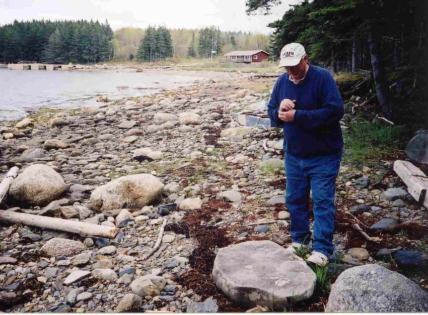
Location of Oak Island, Nova Scotia

44.5º

                                              3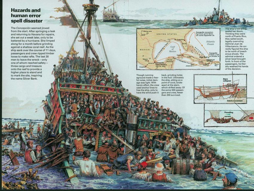
Oak Island in the 1500s?

                    C: Raso
            (Cape Race Nfld)

    44.5º                                                        Oak Island?
                     Mahone Bay?

In the 1500s, during the Portuguese
voyages of discovery, islands in the
New World were seeded with
livestock and crops to have fresh
supplies for future voyages.
(Vigneras 1973)                        Bartolomeu Velho Map 1560 (Portuguese)

                                                                                4
Oak Island Lot Distribution
      Present Ownership (2007)
      Lot 5 – Robert Young
      Lots 9 to 12 and 14 – Fred Nolan
      Lot 13 – John Johnston
      Lot 23 – Dan and David Blankenship
      Lot 25 – Alan Kostrzewa (Michigan Group)
      Remaining 23 Lots – Dan Blankenship and
                           Michigan Group

                                          The Treasure Trove License is in
                                          the possession of Oak Island
                                          Tours which is a Company
                                          formed by the Michigan Group.

                                                                             5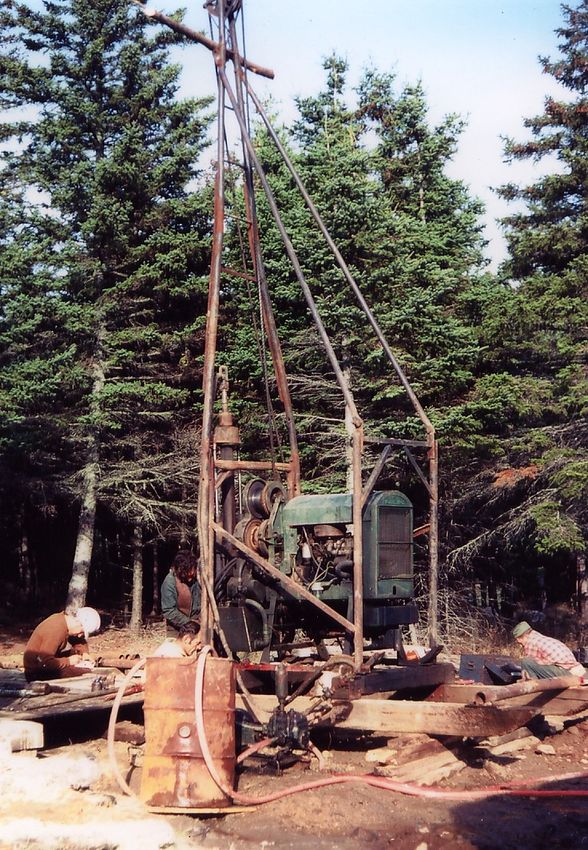
Outline of Presentation

1.   Introduction
2.   Geological, Geotechnical and Hydrogeological Conditions
3.   Archaeological Findings at Money Pit from 1967
4.   Search by Ron Aston 1999 to 2001 (North Carolina)
5.   Search by Petter Amundsen 2003 (Norway)
6.   Main Theories
7.   Challenges for Exploration at the Money Pit
8.   Challenges for Excavations within the Money Pit

                                                               6
Bedrock Geology Western Mahone Bay

        Boundary of
     Windsor Group and
      Maguma Group

                         Ref: Giles 1981
                                           7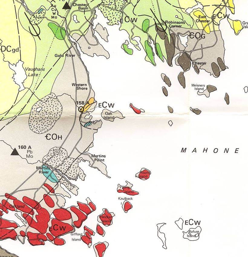
Geological
Section of
Oak Island

                      160 Feet   Money
                       Glacial    Pit
                         Till

             Meguma
                           200 Feet
              Slate
                           Anhydrite
                            Bedrock

                                         8
Surface Geology and Drumlins
    Western Mahone Bay                      Drumlins

             Oak Island

                          BAY

                                            Drumlins

                                Ref: Stae and Fowler 1981

                                                            9
Glacial Phases and Effect on Drumlin Formation

                     SSE
       Phase 1             Phase 3
       40-75 ka            15-18 ka

                      SE
        Phase 2              Phase 4
         21 ka               12-13 ka

                    Ref: Stae and Brown 1989

                  Ref: Eyles 1983
                                                 10
Chart of Glacial Deposition in Nova Scotia
Wood at 125 feet in
Phase 4 Golder BH 202 Carbon
12-13 ka Dated to 25 000 yrs BP
11.5
13
15.5
Phase 3 18
15-18 ka
23.5
Phase 2
21 ka
30
40
Phase 1
40-75 ka 50
75
100
200
Ref: Stae 2004
11Land Submergence
with Rise in
La
ur
Sea Level
en
tia
n
Continential
Ch
Shelf
an
n
el
Mahone Bay
a Lagoon 1
8000 yrs BP
WL -30m
Mahone Bay 3
0 yrs BP
WL 0m
Mahone Bay
Connected 2
to Ocean
Ref: Daigle 2005
6000 yrs BP
WL -18m 12Connection of Mahone Bay to Ocean
6000 Years BP
18 m
Ref: Barnes and Piper 1978
13Relative Sea Level Curve for Atlantic Canada
Original
Oak Island
20 15 10 5 Works 0
Lagoon in Mahone
Bay connected to
Ocean 6,000 years
before present
( sea level –18m)
Lowstand about
70 m (230 feet)
below present
sea level 12,000
years ago
Ref: Stae et al 2001
14Mutlibeam Bathymetry at Oak Island July 1996
Boundary
between muddy
sand and gravel
with boulders
non-depositional
channel
Smith’s
Cove
SE Phase 4
12-13 ka BP
SSE Phase 3
15-18 ka BP
Water Depth muddy
about 30 feet sand
Ref: Fader and Courtney 1998
15Side Scan Survey by Dave Delaney Aug 05
20 Feet
16Geological Profile at Money Pit and 10X
10X
Money
Pit
Stoney Till and
Lawrencetown Wood at 125 feet in
Flood Tunnel
Till 12-30 ka BP Golder BH 202 Carbon
at Money Pit Dated to 25 ka BP
Interglacial
Deposits Hartlen Till
40-75 ka BP
Broken Anhydrite
Competent
Anhydrite
17Geotechnical Investigations at the Money Pit
1. Becker Drilling 1967
2. Warnock Hersey 1969
3. Golder Associates 1970
4. Detection Program Drilling 1993
18Plan of Exploration Boreholes
A
A-
n
io
ct
Se
Se
ct i
on 10X
B-
B
Golder WH
Geotechnical Holes
Archaeological Holes
10X
o Fence Around
hot
P Money Pit
19Geotechnical Section A-A at Money Pit and 10X
10X
Money
Pit
SAND
Clayey LAYER
Till IN SAND
LAYER
Intrerglacial
Clays and Silts Silty
Till
Broken Anhydrite
Competent Anhydrite
Note: Broken Anhydrite Scenarios
Historical shafts, tunnels and 1. Fractured bedrock with cavities and soil infillings
drill holes are not shown 2. Huge anhydrite boulders in soil matrix
20Geotechnical Section B-B at Money Pit
and Dunfield Excavation
Money
Pit
Photo
Dunfield
Excavation
Clayey
Till
Intrerglacial
Clays and Silts
Silty
Till
Hedden Chappell
Shaft Shaft
Broken Intact Collapsed
Anhydrite
Competent
Anhydrite
Note:
Historical shafts, tunnels and
drill holes are not shown Dunfield Excavation 1965/66
21Depth of Cavity/Soil Zones in Broken Anhydrite
Distance and Anhydrite Depth of Cavity/Soil Zone Within Anhydrite (Feet) Thickness Anhydrite
Hole Direction Thickness Thickness
of Zone
No from Money Above Zone Cavity or Below Zone
Pit (Feet) (Feet) Cavity Loose Soil Dense Soil (Feet) (Feet)
Loose Soil
195? – 204
W1 50 NE 20 - 181 - 186 186 – 195? 24 46
N=58
70
5 166 – 170 - 170 – 178 12
W3 61 NW Inc Soil Layer
8 - - 186 - 197 11 51
W5 19 S 8 - - 180 - 206 26 4
W6 120 SSW No cavities or soil zones encountered in broken anhydrite
W7 17 S 15 - - 180 - 209 29 9
10X 176 NE 50 230 - 235 - - - 5 26
217 – 227
G101 73 S 53 - - - 10 23
N>100
214 – 219
G102 50 S 52 - - - 5 22
N=61, 58
185 – 200 200 – 205
G103 10 E 28 - - 20 43
Reworked N>100
209 – 216
G104 72 SSW 47 - - - 7 36
N=41, 67
G202 174 NE 43 - - 217 – 238 Ft 21 5
217 – 236
G204 267 NE 13 211 - 213 - 213 - 217 23 7
N=34-100
Note: Twelve geotechnical and archaeological holes extended into the broken anhydrite. Eleven of the 12 holes encountered
cavity/soil zones in the broken anhydrite.
22Gradation of Overburden and Soil Infill in Anhydrite
Silty Till
Overburden
Silty Clay
Overburden
Interglacial
Deposit
Silty Till Infill
in Broken
Anhydrite
Clay Layers
in Broken
Anhydrite
Ref: Golder 1971 23Gradation Test Samples of Soil Infilling
Golder Hole G202 Located 3 Feet West of Hole 10
0
20
Mean Sea
Level 43 Feet
40
60 Glacial Till
0 to 181 Feet
80
100
Depth - Feet
Loose Zone
125 to 130
Log for
120 Borehole
G202
140
160 6” Rotary
Drilling
180 to 184
Geotechnical Bedrock
Drilling 181 to
200
184 to 243.5 212.2 Feet Gradation
Layers of Soil and Rock 212.2 to 228.0 Tests
220
Clay and Glacial Till 228.0 to 238.2
240 Sound Anhydrite 238.2 to end at 243.5
Ref: Golder 1971
24Gradation of Soils in Hole G202 - 228 to 238 Feet
Sym SA Depth Soil
21 228.5 Clay
22A 230.5 Clay
23 232.5 Till
25 236.5 Till
26 237.5 Till
Ref: Golder 1971
25Plan of Cross Hole Tomography Panel D
e t)
Fe
0
(7
l D
n e
Pa
26Photo Showing Location of
Cross Hole Tomography Panel D
Panel D (70 Feet)
27Profile of Tomography Results for Panel D
Money Money
Pit Pit 93-03
93-04
Panel D
Tomography Data Ref: Platt 1995
28Plan of Woods Hole Tidal Hydrogeology
Testing in July 1995
Water Level
Water Level Recorded in
Recorded in 10X Triton Shaft
Good Tidal No Tidal
Response Response
Water Level
Recorded in
Hole 93-03
Limited Tidal
Response
The salinity of the groundwater in
the anhydrite is about 50 to 75 %
Tidal Level that of sea water
Recorded in
Mahone Bay
Ref: Woods Hole Oceanographic
Institution 1996
29Water Level Variation in 10X from Tidal
Variation in Mahone Bay
1.5 m
Time Lag 1 Hour
0.65 m
Time Lag 1 Hour (Between Peaks)
Ratio of Amplitudes = 0.43 (0.65/1.5)
Ref:
Woods Hole Oceanographic
Institution 1996
(Measurements made in July 1995)
30Water Level Variation in Coarse Rockfill
Dump from Tidal Variation in Rupert Inlet
Well W2
Section
1000 m
Well W2
60 m
Flow reversals occur
in the rock dump in Ref:
phase with the tide BHP Billiton 2004
31Water Level Variation in Coarse Rockfill Dump
from Tidal Variation in Rupert Inlet
Water Level in Rupert Inlet
2.0
Water Level (m)
1.0
0.0 3.4 m
-1.0
-2.0
30-Jun-01 01-Jul-01 02-Jul-01 03-Jul-01 04-Jul-01
Date
Time Lag 1 Hour
Water Level in Rock Dump Well W2
2.0
Water Level (m)
1.0
0.0
2.3 m
-1.0
-2.0
30-Jun-01 01-Jul-01 02-Jul-01 03-Jul-01 04-Jul-01
Date
Time Lag 1 Hour (Between Peaks) Ref:
Ratio of Amplitudes = 0.68 (2.3/3.4) BHP Billiton 2004
32Particle Track El. –10 m at 100 m from Shoreline
k (Coarse Rockfill) = 25 cm/s
2.0 7 hours
Water Level in Rupert Inlet (m)
1.0
0.0
-1.0
-2.0
0 5 10 15 20 25
Well # 5 Time (hr)
Well # 6
100 m Well # 4 600 m
A C
B D
Particle track for two tide cycles Particle track for two additional cycles
10.0 2.0
Point A - Elevation – 10 m Natural Scale 1 : 250 Point A - Elevation – 10 m Exaggerated Vertical Scale
Horiz.: 1:250 Vert.: 1:50
Particle Movement
V e rt ic a l D is t a n c e ( m )
Vertical Distance (m)
5.0 1.0 20 m Horiz and 1 m Vert in 7 hours
5 hr
15 hr 24.8 hr 0 hr 20 hr
0.0 0.0
10 hr Ref:
BHP Billiton 2004
-5.0 -1.0
-10 0 10 -10 0 10
Horizontal Distance (m) Horizontal Distance (m)Lab Scale Testing of Anhydrite Solubility
36 mm
Diameter 36 mm
(1.4 in) Diameter
(1.4 in)
360 mm
(14 in)
Distilled water
Ref: flow at
James and 56 ml/day
Lupton 1978 (2 fluid oz/day)
for 44 days
2.5 mm 6 mm
Diameter Hole Diameter Hole
Before Test After Test
Sketch to
Scale
34Example Flow System
through Anhydrite
from Mahone Bay
to Money Pit and 10X
The flow system through
anhydrite is activated by
pumping at the Money Pit or
10X.
When there is no pumping the
groundwater in the anhydrite
is subject to flow reversals in
phase with tidal variations.
Both of these water movement
systems result in dissolution of
anhydrite and increasing
permeability with time.
35Outline of Presentation
1. Introduction
2. Geological, Geotechnical and Hydrogeological Conditions
3. Archaeological Findings at Money Pit from 1967
4. Search by Ron Aston 1999 to 2001 (North Carolina)
5. Search by Petter Amundsen 2003 (Norway)
6. Main Theories
7. Challenges for Exploration at the Money Pit
8. Challenges for Excavations within the Money Pit
36Becker Drill Setup 1967
Drive Pipe
5.5” o. d.
Inside Pipe
3” i. d.
37Rotary Drilling
Rotary Drill Rotary Drill String Schematic of Rotary Drilling
38Becker Drilling Program at Money Pit 1967
1. The objective of the Becker drilling
program was to drill through overburden
to bedrock surface in search of the
presumed treasure chests at 100 and 150
feet.
2. The first 10 holes extended to bedrock
surface at depths of 145 to 165 feet.
3. The 11th hole (B11) extended to a depth of
200 feet before bedrock was encountered.
Puddled clay was found from 184 to 200
feet and two oak buds were found
embedded in the puddled clay at 196 feet.
4. This singular finding initiated the
extension of all holes to 200 feet with the
use of tricone drilling in bedrock.
11th Hole
Deep Rock 5. 40 holes were drilled at the Money Pit from
200 Feet and January to June 1967.
Oak Buds 6. The drilling resulted in the major milestone
of finding man made cavities in the
bedrock at 200 feet and this was
First 10 Holes completely unexpected.
Found Rock at 7. Lateral drift measurements were not made
145 to 165 Feet in the Becker holes but were made in 5
as expected deep detection holes done in 1993
39Lateral Drift in Deep Detection Holes 1993
Lateral Drift 1. Five deep holes to about 250
93-01 17 Feet over feet were put down in 1993 for
263 Feet Depth a geophysical detection
Money Pit program.
2. Lateral drift was measured in
93-03
93-02 the 5 detection holes and in
Hole B24/W8.
3. This provided an understanding
of the importance of lateral
drift which was not measured
in the previous Becker Holes.
B24/W8
Hole Depth Lateral
No. (Feet) Drift (Feet)
93-04
93-01 240 2.6
93-05
93-02 240 1
93-03 263 17
93-04 240 6
93-05 225 14.5
B24/W8 190 15
40Plan of Deep Rock Area at Money Pit
Holes W2 and W9
probably drifted
laterally to the North
41Geotechnical Drilling and Split Spoon Sampling
Split Spoon Sampler in Open Condition
Showing Recovered Sample
Schematic of
Split Spoon
Sampling
Geotechnical Drill at Oak Island
42Golder Holes of Archaeological Interest
North
Borehole G201
100 Feet North-
Northeast of 10X
Borehole G103 Borehole G202
at Money Pit at 10X
Borehole G102
50 feet South
of Money Pit
43Pollen Count Results for Soil Samples
from Broken Anhydrite 1970
50 Ft
Hole G103
Ref: Ritchie 1970 Sa 27 and 30
In Hole 103 “the occurrence of Recent Soil
aggregations of typical post-glacial
and recent pollen types in addition Inclusions
to the ‘normal’ rare isolated pollen 193 to 200 Ft
types (Carpinus, Ulmus) suggests
strongly that recent or post-glacial Hole G102
material has been mixed Sa 36 and 37
secondarily with the primary Glacial Soil Hole G103
matrix.”
214 to 219 Ft Sa 27 and 30
In Hole 102 “The macroscopic Recent Soil
appearance of the matrix and the
occurrence of isolated grains of Hole G102 Inclusions
Ulmus, Carpinus and Fagus is Sa 36 and 37 193 to 200 Ft
characteristic of glacial till.” Glacial Soil
214 to 219 Ft
44Pollen Count Samples from G102 and G103
G102 G103
Samples Samples
36 and 37 27 and 30
Undisturbed Recent Soil
Glacial Soil Inclusions
214 to 219 Ft 193 to 200 Ft
Sa 36 N=61 Sa 27 N=24
Sa 37 N=80 Sa 30 N=26
Ref: Golder 1971
45Wood and Metal in Golder Hole G202
Located 3 Feet West of Hole 10 June 1970
0
20
Mean Sea
Level 43
40
Wood
60
Wood at 125 in
80 Rotary Drill Hole
(Note1)
100
Depth - Feet
Loose Zone
125 to 130 One Inch Log for
120 Borehole
Metal at 150
or Higher in
G202
140
Rotary Drill Hole
(Note 2) One Inch
160 6” Rotary
Drilling
180 to 184
Bedrock
181
200 Metal
Geotechnical
220 Drilling
184 to 243.5
240
Notes: Ref: Golder 1971
1. Wood sample was carbon dated to 25,000 years BP (Terasmae 1970) and
was identified as Eastern Spruce (University of Toronto 1970).
2. Metal was identified as iron which consisted of much siliceous replacement
material, the sample was of considerable age (Stelco 1970b – Nov 19). 46Metal Fragments in Golder Borehole G201
One Inch
Metal
et
Fe
Borehole G201 fragments are
0 friable wrought
26
iron dating
prior to 1800
Borehole 10X (Stelco 1970b)
and G202
Money Pit Ref: Golder 1971
Money Pit Borehole G201
Metal Borehole G201
fragments Sample 10
12’ Sand found 84.5 to 86.5 Ft
Inclusion embedded in N = 121
sand sample
2’ Sand during sieve
Inclusion analysis
with Metal (Golder 1971)
Fragments
Ref: Golder 1971
47Plan of Archaeological Sections at Money Pit
D
C
C
D
48Archaeological Section C-C at Money Pit
Broken
Anhydrite
BRASS FOIL
The brass foil was likely
made by the early
process of adding
Competent charcoal and calamine to
Anhydrite copper dating from the
alchemist period to about
1850 (Stelco 1970a).
49Archaeological Section D-D at Money Pit
Broken
Anhydrite
Competent
Anhydrite
50Summary of Archaeological Features at Money Pit
Brass, Oak Buds
and Charcoal in
/14 Puddled Clay
(INFERRED CHAMBER)
51Do We Have Proof of Original Work at the
Money Pit According to the Criteria of Othello?
Othello: So prove it
That the probation leave no hinge nor loop
To hang a doubt on
“OTHELLO, The Moor of Venice” (Shakespeare)
52Conclusions for the Money Pit
1. There are chambers at 200 feet depth at the
Money Pit. Possibilities:
• The chambers were made and nothing was put in
them
• The chambers were made, something of great
value was put in them and then taken away
• The chambers were made, something of great
value was put in them and is still there
2. We don't know who did it or what is there, the
mystery remains unsolved.
53Outline of Presentation
1. Introduction
2. Geological, Geotechnical and Hydrogeological Conditions
3. Archaeological Findings at Money Pit from 1967
4. Search by Ron Aston 1999 to 2001 (North Carolina)
5. Search by Petter Amundsen 2003 (Norway)
6. Main Theories
7. Challenges for Future Exploration at the Money Pit
8. Challenges for Excavations within the Money Pit
54Plan of Ron Aston Search Area
Ron Aston
Search Area
55Ron Aston and Others 2001
Murray Jim David Ron David
MacPhie Harvey Tobias Aston Tobias
56Ron Aston Drilling Program August 2001
57Boulder in Glacial Till Exposed by Aston 2001
58Large Boulder at Shore
59Outline of Presentation
1. Introduction
2. Geological, Geotechnical and Hydrogeological Conditions
3. Archaeological Findings at Money Pit from 1967
4. Search by Ron Aston 1999 to 2001 (North Carolina)
5. Search by Petter Amundsen 2003 (Norway)
6. Main Theories
7. Challenges for Future Exploration at the Money Pit
8. Challenges for Excavations within the Money Pit
60Happy Norwegians May 2003
Eric Hauan
Petter Amundsen
Tony Ronning
Sigbjorn Larsen
61Plan of Petter Amundsen Search Area 2003
Boulder cross found
by Fred Nolan in 1981
and made public in 1992
.
.
Petter Amundsen
Search Area
. . .
. .141 Ft
282 Ft
62Kabalistic Tree of Life and Rosicrucian Cross
63Boulder 282 Feet South of Cross
64Boulders at Shore
65Boulder 141 Feet South of Cross
Presumed primitive
sun with radial lines
66Outline of Presentation
1. Introduction
2. Geological, Geotechnical and Hydrogeological Conditions
3. Archaeological Findings at Money Pit from 1967
4. Search by Ron Aston 1999 to 2001 (North Carolina)
5. Search by Petter Amundsen 2003 (Norway)
6. Main Theories
7. Challenges for Future Exploration at the Money Pit
8. Challenges for Excavations within the Money Pit
67Knights Templar
68Sir Francis Drake and Queen Elizabeth 1
Does the Queen have Drake's Missing Logs?
Sir Francis Drake 1540 - 1596 Queen Elizabeth I 1533 - 1603
69Sir Francis Bacon and William Shakespeare
The Missing Original Manuscripts and
The Bacon-Shakespeare Authorship Controversy
Sir Francis Bacon William Shakespeare Shakespeare's First Folio
1561 - 1626 1564 - 1616 1623
70Spanish Galleon Lost at Sea
71Portuguese Map of the New World 1560
C: Raso
(Cape Race Nfld)
44.5º Oak Island?
Mahone Bay?
In the 1500s, during the Portuguese
voyages of discovery, islands in the
New World were seeded with
livestock and crops to have fresh
supplies for future voyages.
(Vigneras 1973) Bartolomeu Velho Map 1560 (Portuguese)
72Portuguese Flag Symbol from 1500s
Compared to Engraved Hedden Stone
Four Portuguese Bezants
and central cross??
Escutcheon
(or Quina)
containing five
Bezants (white dots)
Portuguese Flag 1495 to 1577 Engraved granite stone found by
Hedden in 1936
73Sinking of the Conceptión 1641
500 People
on board
200 People
Survived
Ref: Bowden
1996
(National
Geographic)
74Sir William Phips and Recovery of the
Treasure from the Conceptión 1688/89
Ref: Bowden 1996 (National Geographic)
75Treasure from the Conceptión (Leftovers)
(Nuesta Señora de la pura y limpia Conceptión)
Articles recovered in 1978 by Burt Webber
Ref: Bowden 1996 (National Geographic)
76Pirates 1883 2006 77
Theories - Who Buried What and When?
         Who                            What                           When
1. The Knights            The treasure of the Knights
                                                               1300s to 1400s
   Templar                Templar (The Holy Grail)
                          Treasure from damaged Spanish
2. Spanish                                                     1500s
                          Galleon which sunk on way home
                          Treasure stored on several
3. Spanish                                                     1500s
                          occasions in underground vaults
4. Portuguese             Treasure from the Azores             Mid 1500s
5. Sir Francis Drake      Plundered Spanish treasure           Late 1500s
                          The original Shakespearean
6. Sir Francis Bacon                                           1600s
                          Manuscripts
                          Treasure from French pay ship
7. French                                                      Mid 1700s
                          destined for Fortress Louisbourg
                          Treasure from the Spanish            Money Pit 1688-89
8. Sir William Phips
                          Galleon Conceptión sunk in 1641      Flood Tunnel 1752-54
9. Conspirators from      Spoils from the sack of Havana in
                                                               Shortly after 1762
  the British Military    1762
Note: Other less credible theories include Early Civilizations, Egyptians, Incas,
      Mayans, Aztecs, Mi’kmaq, Vikings, Acadians, Pirates and Aliens.
                                                                                      78
Outline of Presentation
1. Introduction
2. Geological, Geotechnical and Hydrogeological Conditions
3. Archaeological Findings at Money Pit from 1967
4. Search by Ron Aston 1999 to 2001 (North Carolina)
5. Search by Petter Amundsen 2003 (Norway)
6. Main Theories
7. Challenges for Exploration at the Money Pit
8. Challenges for Excavations within the Money Pit
79Objectives of Exploration at the Money Pit
1. Locate treasure and artifacts.
2. Define the nature of the man made workings.
3. Identify the historical context.
80Challenges for Exploration at the Money Pit
1. Define specific targets for investigation by remote sensing or drilling based
on available evidence.
2. Evaluate the suitability of geophysical methods to find the presumed
treasure chests in the overburden and to identify specific targets for
exploration, including possible offset chambers.
3. Evaluate the suitability of geophysical methods to define the contents and
configuration of the chambers in rock and to identify specific targets for
exploration.
4. Evaluate suitable small diameter drilling methods to recover samples, to
reach targets and to control/measure lateral drift.
5. Evaluate large diameter drilling methods for man access and identify
limitations due to expected water conditions.
6. Evaluate suitable tools for down hole inspection below the water level in
small and large diameter holes and identify the best method to manage
turbid water for better visibility.
7. Define a suitable testing program for recovered samples of "puddled clay"
for positive identification of origin.
8. Search for historical construction projects similar to the Oak Island Money
Pit and Flood System.
9. Develop a program of exploration with a high chance of success.
81Outline of Presentation
1. Introduction
2. Geological, Geotechnical and Hydrogeological Conditions
3. Archaeological Findings at Money Pit from 1967
4. Search by Ron Aston 1999 to 2001 (North Carolina)
5. Search by Petter Amundsen 2003 (Norway)
6. Main Theories
7. Challenges for Exploration at the Money Pit
8. Challenges for Excavations within the Money Pit
82Objectives of Excavations within the Money Pit
Preamble
Objectives for excavations can be defined based on present evidence or
based on additional evidence to be obtained from an exploration
program.
Based On Present Evidence
1. Small shaft to access a specific area for exploration and possible
recovery of treasure and artifacts (not likely to be done before
additional exploration, Chappell and Hedden were not successful).
2. Large diameter shaft to find the chests in overburden and to access the
chambers in bedrock (not likely to be done unless one has lots of
money and only wants to solve the mystery).
Based on Additional Exploration
3. Small shaft to access a specific area for recovery of treasure and
artifacts.
4. Large diameter shaft of a size and depth which is based on specific
evidence.
83General Challenges for a Large Diameter Deep Shaft
Excavation at the Money Pit Based on Present Evidence
1. Select a shaft diameter which is Section
consistent with the required
objectives.
2. Allow for the numerous obstructions
in the overburden and the difficult
water control issues associated with
pervious broken anhydrite zone.
3. Select a design concept and
construction procedures which are
consistent with the need to minimize
disturbance to original works.
4. Allow for lateral excavation along
original tunnels (to possible offset
chambers) which may extend
beyond the walls of the shaft. Assumed Shaft
5. Respect archaeological regulations Diameter 70 feet
while maintaining a reasonably
efficient construction schedule. Plan of Archaeological Features
and Assumed Shaft Location
84Specific Challenges for a Large Diameter Deep Shaft
Excavation at the Money Pit Based on Present Evidence
1. Boulders in glacial till
2. Open and soil filled cavities in broken
anhydrite
3. Saline groundwater in anhydrite
Assumed
4. Cyclic groundwater movement in anhydrite Shaft
Diameter
due to tides 70 feet
5. Very high permeability zones in broken
anhydrite
6. Reworked soil zones resulting from events
such as collapse of the Money Pit in 1861
and the Dunfield excavation of 1965/66
7. The presence of timbers and debris from
numerous previous shafts and tunnels in the
area of the Money Pit
8. Steel casings and pipes remaining in the
ground from previous drilling operations Section
85Expected Outcome of a Large Diameter Shaft
Excavation at the Money Pit
1. A large diameter shaft excavation to bedrock surface is expected
to resolve the nature of the presumed chests with coins drilled at
100 feet in 1849 and 155 feet in 1897, and the parchment may be
recovered.
2. A shaft excavation to 200 feet is expected to recover significant
evidence (and possibly artifacts and treasure) which will result in:
• An obvious solution to the mystery is obtained (possibly by
recovery of the parchment).
• A solution is determined in conjunction with related historical
and archaeological studies or verification.
• The Oak Island mystery is not resolved (very unlikely
outcome).
86When
Treasure is
Recovered
Ref: David Tobias
87References 1 of 2
1. Barnes, Neal E. and Piper, David J. W. 1978. Late Quaternary geological history of Mahone Bay, Nova Scotia.
Canadian Journal of Earth Sciences, Vol.15, 1978, pages 586-593.
2. BHP Billiton 2004. Island Copper Mine, 2004 Closure Plan Addendum. Report prepared by Rescan, Geocon
and SRK Consulting, September 2004.
3. Bowden, Tracy 1996. Treasure From the Silver Bank, National Geographic, July 1996.
4. Daigle, Réal 2005. The Impacts of Sea-Level Rise and Climate Change on Southeastern New Brunswick.
Proceedings, Adapting to Climate Change in Canada, Ottawa, May 4, 2005.
5. Eyles N. (Ed) 1983. Glacial Geology: An Introduction for Engineers. Pergamon Press, 1983.
6. Fader, G.B.J., and Courtney, R.C. 1988. An Interpretation of Multibeam Bathymetry off Eastern Oak Island,
Mahone Bay, Nova Scotia. Geological Survey of Canada (Atlantic), Bedford Institute of Oceanography, issued
April 1998.
7. Giles, P. S. 1981. The Windsor Group of the Mahone Bay Area, Nova Scotia. Nova Scotia Department of
Mines and Energy, Paper 81-3, 1981.
8. Golder Associates, Subsurface Investigation, The Oak Island Exploration, Oak Island, Nova Scotia. Draft
Report No. 69126 to Triton Alliance Ltd., Montreal, Quebec, April 28, 1971.
9. James, A. N. and Lupton, A. R. R.1978. Gypsum and anhydrite in foundations of hydraulic structures.
Geotechnique, The Institution of Civil Engineers, London, Vol. 28, Sept. 1978, pages 249-272.
10. Platt, Professor Gerhard R., Imperial College, Department of Geology, London, England, 1995. Re-Evaluation
of Traveltimes for "Panel D" Tomographic Data (Crosshole Seismics at the Oak Island Money Pit). Report to
Bob Atkinson, March 24, 1995.
11. Ritchie, J. C., Professor of Biology, 1970. Report on Palynological Analyses of Four (4) Samples from The Oak
Island Exploration. Dalhousie University Project 69126, May 25, 1970.
12. Stea, Rudolph R. 2004. The Appalachian Glacier Complex in Maritime Canada. In Quaternary Glaciations –
Extent and Chronology, Part II, Editors J. Ehlers and P. L. Gibbard, Elsevier B. V., 2004, pages 213-232.
88References 2 of 2
13. Stea, R. R. and Fowler, J. H. 1981. Pleistocene Geology and Till Geochemistry of Central Nova Scotia. Nova
Scotia Department of Mines and Energy, Map 81-1, 1981.
14. Stea, R. R. and Brown, Y. 1989. Variation in drumlin orientation, form and stratigraphy relating to
successive ice flows in southern and central Nova Scotia, Sedimentary Geology, 62, 1989, pages 223-240.
15. Stea, Rudolph R, Fader, Gordon B. J., Scott, David B. and Wu, Patrick 2001. Glacial and relative sea-level
change in Maritime Canada. In Deglacial History and Relative Sea-Level Changes: Northern New England
and Adjacent Canada, Editors T. K. Weddle and M. J. Retelle, Boulder, Colorado, Geological Society of
America Special Paper 351, 2001, pages 35-49.
16. Stelco (The Steel Company of Canada), Hamilton, Ontario 1970a. Letter Report to Triton Alliance Ltd. by
Allan B. Dove, Senior Development Metallurgist, dated August 22, 1970.
17. Stelco (The Steel Company of Canada), Hamilton, Ontario 1970b. Letter Report to Triton Alliance Ltd. by
Allan B. Dove, Senior Development Metallurgist, dated November 19, 1970.
18. Terasmae, J. 1970. Department of Geological Sciences, Brock University, Letter to Kerry Ellard, Project Co-
ordinator, The Oak Island Exploration, October 3, 1970.
19. University of Toronto 1970. Identification of Wood Species. Report by J. J. Balatinecz, Associate Professor,
to H. Q. Golder & Associates Limited, July 8, 1970.
20. Vigneras, L.-A. 1973. The voyages of Diego and Manoel De Barcelos to Canada in the Sixteenth Century.
Terrae Incognitae: The Annals of the Society for the History of Discoveries, Volume V, 1973, pp 61-64.
21. Warnock Hersey International Limited 1969. Soils Investigation, Oak Island, Nova Scotia. Report No. 530-
110 to Carr & Donald & Associates, Toronto, Ontario, July 31, 1969 and November 5, 1969.
22. Woods Hole Oceanographic Institution, Woods Hole, Maine 1996. Oak Island Hydrogeology, Hydrography
and Nearshore Morphology, July - August 1995 Field Observations. Draft Report by David G. Aubrey, Wayne
D. Spencer, Ben Guiterez, William Robertson V and David Gallo, April 8, 1996.
89The Technical Challenges of Exploration and Excavation
at the Money Pit, Oak Island, Nova Scotia
Western
Shore Money
Pit
Borehole Smith’s
10X Cove
Oak Island 1992 Money
Pit
Presentation by
Les MacPhie
SNC-Lavalin Inc., Montreal
to
Independent Activities
Period 2008
Massachusetts Institute of
Technology Oak Island 1986
Cambridge, MA
January 28, 2008
90You can also read