Tourism & Recreation Manx Marine Environmental Assessment - Gov.im
←
→
Page content transcription
If your browser does not render page correctly, please read the page content below
Manx Marine Environmental Assessment

               Tourism & Recreation

                                              Surfing in Bay ny Carrickey. Photo: R. Lucas, 2012.

MMEA Chapter 7.1

November 2013

Lead author:
Laura Hanley – Isle of Man Marine Plan
Contributions:
Emma Rowan - Department of Infrastructure
Michael Gallagher - Department of Infrastructure
Jennie Quillin - 7th Wave
Keiron Tashgagh - Adventurous Experience
Eleanor Stone - Manx Wildlife Trust
Dave Reekie, Wil Kelly, Ranulf Lucas – Independent
Kristian Cowin, Shaun Gelling, Graham Watson, Phil Styles, Jess Collister, Jo Brew -
Department of Environment, Food and Agriculture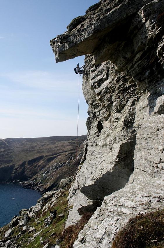
MMEA Chapter 7.1 – Tourism and Recreation

           Manx Marine Environmental Assessment

Version: November 2013

© Isle of Man Government, all rights reserved

This document was produced as part of the Isle of Man Marine Plan Project, a cross Government
Department project funded and facilitated by the Department of Infrastructure, Department of
Economic Development and Department of Environment, Food and Agriculture.

This document is downloadable from the Department of Infrastructure website at:
http://www.gov.im/categories/planning-and-building-control/marine-planning/manx-marine-
environmental-assessment/

For information about the Isle of Man Marine Plan Project please see:
http://www.gov.im/categories/planning-and-building-control/marine-planning/

Contact:
Manx Marine Environmental Assessment
Isle of Man Marine Plan Project
Planning & Building Control Division
Department of Infrastructure
Murray House, Mount Havelock
Douglas, IM1 2SF

Suggested Citations
Chapter
Hanley, L., Rowan, E., Gallagher, M., Quillin, J., Tashgagh, K., Stone, E., Reekie, D., Kelly, W., Lucas,
R., Cowin, K., Gelling, S., Watson, G., Styles, P., Collister, J., Brew, J. 2013. Tourism and Recreation.
In Hanley et al., (eds.), Manx Marine Environmental Assessment. Isle of Man Marine Plan. Isle of Man
Government, pp. 48

MMEA
Hanley, L.J., Gell, F.G., Kennington, K., Stone, E., Rowan, E., McEvoy, P., Brew, M., Milne, K.,
Charter, L., Gallagher, M., Hemsley, K., Duncan, P.F. ( eds.) 2013. Manx Marine Environmental
Assessment. Isle of Man Marine Plan. Isle of Man Government.

Manx Marine Environmental Assessment – November 2013

                                                                                                        2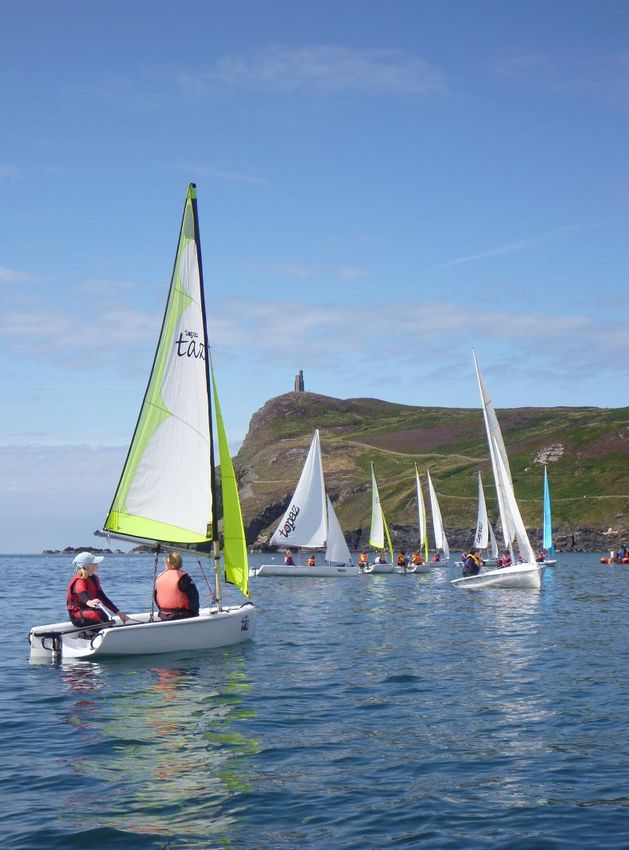
MMEA Chapter 7.1 – Tourism and Recreation

Disclaimer:

The Isle of Man Government has facilitated the compilation of this document, to provide baseline
information towards the Isle of Man Marine Plan Project. Information has been provided by various
Government Officers, marine experts, local organisations and industry, often in a voluntary capacity
or outside their usual work remit. Advice should always be sought from relevant contacts where
queries arise.

The editors have taken every care to ensure the accuracy of the information contained but accept
that errors, omissions or changes may be present which may be identified in future. The editors
accept no responsibility for the accuracy or currency of information provided on external sites.

All MMEA chapters may be amended and improved upon in light of new information or comments
received. As such, all chapters should be considered as working documents.

Any initial guidelines or recommendations within the document are provided to help facilitate future
discussions between stakeholders, Government Departments, future developers and the general
public, and should be read only in the context of the document as a whole. This document does not
provide legal or policy advice but rather a statement of known information about Manx territorial
waters.

The mapping detail contained in this document is subject to the limitations of scale and depiction of
any feature, does not denote or infer right of way and no claim is made for the definitive nature of
any feature shown on the mapping. New marine datasets created for the project have not been
subject to formal verification.

Copyright:

Unless stated otherwise, all mapping, overlay data and intellectual property in this publication are
subject to the following copyright:

Charts: © Crown Copyright, Department of Infrastructure, Isle of Man. 2012.

United Kingdom Hydrographic Office admiralty charts: © SeaZone Solutions Ltd. Licence no. 2005,
[GDDI/10 & 012011.006]. © British Crown Copyright, 2005.

NOT TO BE USED FOR NAVIGATION

Reproduction of the maps in any form is prohibited without prior permission from the publishers.

Manx Marine Environmental Assessment – November 2013

                                                                                                        3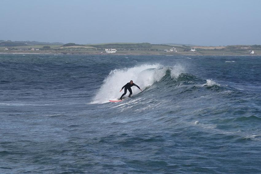
MMEA Chapter 7.1 – Tourism and Recreation

Introduction
The Isle of Man is a beautiful island with breathtaking scenery, unspoilt beaches, heather
moorlands and a relaxed pace of life. By plane or boat the Island is within easy reach of
England, Scotland, Ireland, Northern Ireland and Wales and for the thousands of visitors
who are welcomed each year it is an unforgettable holiday and short break destination.

Marine Tourism and Recreation is recognised to be increasingly important economically to
the Island and this chapter contains a brief introduction to the current tourism and
recreation activities and facilities in Manx territorial waters and at the coast.

It is not the intention to provide detailed information on each activity and facility of the Isle
of Man; instead this summary provides an initial baseline, contacts for key groups and
organisations and links to other key sources of local information.

A brief and initial assessment of potential generic effects (which may affect tourism and
recreation activities) from future developments in Manx waters is also provided. At this
strategic level there are considerable uncertainties associated with the latter, as it deals with
human responses to changes in the marine environment and the nature and scope of future
developments are unknown. Consequently only very general comments can be made.

Baseline information is also provided in other chapters of the MMEA.

Table 1 Other chapters featuring information relevant to Tourism and Recreation.

Further baseline information                          Chapter
Search and Rescue Services – e.g. Marine Operations   See MMEA Chapter 6.2 – Shipping and
Centre, IOM Coastguard and the RNLI.                  Navigation
Marine protected areas – for fisheries and            See MMEA Chapter 3.7 - Marine and Coastal
conservation purposes                                 Conservation.
                                                      See MMEA Chapter 4.1 - Commercial
                                                      Fisheries and Sea Angling
Water and sediment quality                            See MMEA Chapter 2.4. Marine Pollution
Marine mammals, basking sharks and birds              Chapters within MMEA Ecology/ Biodiversity
                                                      Section (3.4, 3.5 and 3.6)
Underwater and coastal habitats, species and          Chapters within MMEA Ecology/ Biodiversity
features.                                             Section (3.1, 3.2 and 3.3).
Coastal Geological features                           See MMEA Chapter 2.4.Coastal Geology.
Cultural heritage assets (e.g. shipwrecks).           See MMEA Chapter 5.1 Marine and Coastal
                                                      Historic Environment

Manx Marine Environmental Assessment – November 2013

                                                                                                    4
MMEA Chapter 7.1 – Tourism and Recreation
Baseline
The Isle of Man has approximately 118km of coastline, predominantly cliff-backed rocky
shore, with sheltered sandy bays in the south and long exposed sand or shingle beaches in
the north. A wide range of land-based activities take place along the Manx coast, including
walking, hiking, cycling, camping, golf, beach recreation, bird and marine wildlife watching,
rock pooling, horse riding, angling and occasionally the use of motorised vehicles. The most
important examples of land-based leisure infrastructure on the coast and adjacent to it are
the golf courses, campsites and rural car parks (which provide access points necessary for
most land and water based leisure activities). The steam railway and tram network also
operates along several key stretches of the Manx coast with views out to sea.
There are great opportunities for visitors and residents to see marine wildlife from shore and
by boat including the resident seals and porpoise, and the occasional dolphin and whale.
The Isle of Man is also a world renowned Basking Shark hotspot with hundreds of public
sightings made predominantly from land, during the summer months (usually May until
September).
Manx waters are extremely diverse and offer excellent scuba diving opportunities, from
scenic shore dives and snorkelling explorations, to technical diving on offshore reefs and
submerged shipwrecks. The Island is well recognised for its progress towards sustainable
fishing with a network of closed and restricted areas for fisheries purposes. In 2011, the
Island designated its first Marine Nature Reserve in Ramsey Bay for both fisheries and
conservation purposes with support of the local fishing industry. It is envisaged that marine
tourism and recreation may benefit indirectly from such initiatives.
Interest in watersports on the Island is stronger than ever and there is a growing uptake of
marine and coastal leisure activities off the coast such as kayaking, scuba diving, jet skiing
kite surfing, coasteering, surfing, wind surfing, sea angling, sea swimming and climbing. The
main infrastructure for water-based activities include marinas (Peel & Douglas), yacht
moorings, dingy parks and launching slips for sailing and power-boat activities. The Island
has remained a popular sailing destination for some time and 6 sailing and yacht clubs are
listed by the Royal Yachting Association (RYA). Visiting yachts and pleasure boats often take
advantage of the local restaurants, amenities and events, and also tend to purchase fuel
and supplies for their vessels thereby adding to the Manx economy.
Many of the other important water sports practised in Manx waters use the same basic
recreational infrastructure, or do not require coastal infrastructure other than land access to
the coast.
Approximately 16 times a year cruise ships visit the island, bringing visitors ashore on
excursions to visit heritage sites, golf courses and key landmarks. There are several
commercial sightseeing tour operators and charter boats available and the Island hosts
several marine and coastal sporting events, festivals and fun days.
Manx Marine Environmental Assessment – November 2013
5MMEA Chapter 7.1 – Tourism and Recreation
Motorsport is one of the biggest tourist draws to the Island and while racing is the key
attraction, many visitors also explore the coast during their stay and visit local attractions.
Popular activities
Watersports – swimming, scuba diving, kayaking, surfing, etc.
Coastal activities & sports – walking, hiking, cycling, sea angling, segway tours.
Heritage and traditional cultural events - visiting castles, monuments and churches,
museums, heritage centres, galleries etc.
Natural history - wildlife excursions (coastal and at sea).
Sightseeing – including round Island tours and charter boat excursions.
Visitor Centres – wildlife and heritage.
Education centres – schools, colleges.
Public engagement - talks by groups, guided walks.
Photography and Marine Art – including local events.
Seasonal activity
No area of the Manx coast is without recreational use. Peak activity at the coast generally
occurs during weekends, bank holidays (including Tynwald Day 5th July) and school holidays
(approx. 25th July – 25th August).
Isle of Man Tourism Awards
Information about the Tourism Awards is available at:
http://www.visitisleofman.com/iom/tourismawards/.
Table 2 Recent winners of the IOM Tourism Awards
Attraction of the Year Best Town
2010 Nautical museum Peel
2011 Trike Tours Laxey
Manx Beaches
Recreational use of the Manx beaches varies greatly, mostly due to accessibility and
facilities. Port Erin, Peel, Ramsey, Laxey and Douglas are the most accessible shores and
relatively sheltered position and sandy beaches make them popular for swimming and
various water sports. The Point of Ayre and the Calf Sound are popular sites to visit, with
good accessibility and parking, however dangerous water currents in these areas limit the
shore usage. There are also many stretches of beach in less developed, quieter, less
accessible locations all along the Manx coast.
Beach/ Water Quality
There are currently no Blue Flag beaches on the Island. Castletown and Debyhaven gained
Recommended Beach status in the 2012 Marine Conservation Society’s Good Beach Guide.
http://www.goodbeachguide.co.uk/.
Manx Marine Environmental Assessment – November 2013
6MMEA Chapter 7.1 – Tourism and Recreation
The Sewage Treatment Plant at Meary Veg has been operating since 2004 and treats
sewage from 67% of the Island’s population, after which the high-quality effluent is
discharged into the Irish Sea off Santon Head. Sewage from Douglas, Onchan, Derbyhaven,
Castletown, Port Erin and Port St Mary no longer discharges untreated to sea locally but is
pumped to a modern sewage treatment works at Meary Veg.
Samples of sea water are tested every two weeks, between May and September, from the
various designated bathing beaches around the Island. The results are then compiled by the
Environmental Protection Unit (of DEFA) and displayed at the sampling points and on the
DEFA website at:
http://www.gov.im/about-the-government/departments/environment,-food-and-
agriculture/environment-directorate/environmental-protection-unit/water-quality/
and
https://www.gov.im/categories/the-environment-and-greener-living/isle-of-man-
government-laboratory/bathing-water-quality/
Progress is underway with a £40m program of work associated with the first phase of the
Regional Sewage Treatment Strategy, which will bring modern sewage treatment facilities to
the remainder of the Island’s towns and villages. Recently completed replacement sewage
treatment plants at Patrick, Dalby, and Bride, and projects for Glen Maye, Glen Mona,
Corony and Jurby have started with design work ongoing for Maughold, Port Lewaigue,
Booilushag, Kirk Michael, Andreas and Ramsey.
A second phase of the Regional Sewage Treatment Strategy, planned for 2016-2021, will
provide sewage treatment facilities for those areas not covered by phase one, which include
Peel, Laxey, Baldrine, Ballaugh, Sulby and the Central Valley.
Information on the IRIS Regional Sewage Treatment Strategy is available at:
http://www.gov.im/water/sewerage/sewerage/iris.xml.
Further information on Manx beaches, facilities and shore characteristics is available in the
1989 Manx Beach Survey, Spence et al (1989). See also MMEA Chapter 3.2 (Coastal
Ecology) and MMEA Chapter 2.4 (Marine Pollution).
Manx Headlands & Cliffs
The rugged Manx coastline facilitates sea angling, coasteering, climbing and there are
numerous nesting seabird colonies. See also: MMEA Chapter 2.3 (Coastal Geology).
Historic and cultural sites
Heritage forms an important part of Island life and there are many historical attractions and
ancient monuments spanning 10,000 years of Manx history. Sites are too numerous list but
prominent attractions include:
Castles
Manx Marine Environmental Assessment – November 2013
7MMEA Chapter 7.1 – Tourism and Recreation
Neolithic sites
Viking burial sites
Standing Stones
Visitor information on each of the Manx museums and heritage attractions is also available
via: Manx National Heritage: http://www.gov.im/mnh/.
MMEA Chapter 5.1 (Marine and Coastal Historic Environment) provides more information
and a list of other key contacts with an interest in Manx heritage.
Harbours & Marinas
Please refer to MMEA Chapter 6.2 (Shipping and Navigation) for information about harbour
and marina facilities. See also: http://www.gov.im/categories/travel,-traffic-and-
motoring/harbours/marinas/
Marine Emergency Response
Please refer to MMEA Chapter 6.2 (Shipping and Navigation) for information about Search
and Rescue services for Manx waters and at the coast including collaborative working
between the volunteer services provided by Isle of Man Coastguard and the Royal National
Lifeboat Institute (RNLI). See also: http://www.gov.im/categories/home-and-
neighbourhood/emergency-services/coastguard/, and http://rnli.org/.
Watersports
Watersports such as sailing, sea swimming, surfing, kitesurfing, kayaking, canoeing, rowing,
coasteering and SCUBA diving are popular pastimes with visitors and local residents. Many
of these activities are not constrained by particular facilities nor sites, although general
trends exist. It is also worth noting that many Manx watersports enthusiasts are not always
affiliated to local clubs and many individuals partake on a more occasional basis.
Sailing & Boating
The Isle of Man offers a range of sailing and boating activities which include yacht racing,
yacht cruising, dingy racing, dingy cruising, personal watercraft, sport boating, power
boating and motor boating.
Manx Marine Environmental Assessment – November 2013
8MMEA Chapter 7.1 – Tourism and Recreation
Dingy sailing in Port Erin Bay. Photo: J. Quillin, 7th Wave. 2011.
Recreational boating is a year round activity although generally seasonal with highest
activity occurring during the summer period (May – September). Often sailing is weather
(wind) permitting/ tide permitting (e.g. Peel & Ramsey harbour access).
There are six sailing clubs on the Island with the Royal Yachting Association (RYA) as their
governing body (Table 3.). Isle of Man Yacht Club and Port St Mary Yacht Club organise
professionally recognised RYA training for both adults and juniors and all clubs run RYA
shore based training courses including first aid and VHF radio courses. There are also two
RYA recognised Sailing schools operating on the Island:
- 7th Wave: http://www.7thwave-iom.com/.
- The Venture Centre http://www.adventure-centre.co.uk/.
Sailing for the Disabled offers adults and children with a wide range of disabilities the
chance to enjoy sailing on Pride of Mann II, a 46` Bavaria cruiser: www.sftd-iom.com.
Manx Marine Environmental Assessment – November 2013
9MMEA Chapter 7.1 – Tourism and Recreation
Table 3 Sailing Clubs on the Isle of Man.
Sailing Clubs
Isle of Man Yacht Club
Port St Mary
Manx Sailing and cruising club, Ramsey
Laxey Sailing Club
Peel Sailing Club
Castletown and Derbyhaven motorboat and yacht
club.
Locations
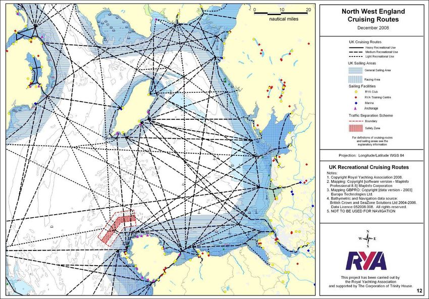
The UK Coastal Atlas of Recreational Boating (2008) by The Royal Yachting Association,
supported by The Corporation of Trinity House, provides a comprehensive set of charts
defining the cruising routes; general sailing and racing areas used by recreational craft
around the UK coast and includes Manx waters.
This includes Manx waters in a wider Irish Sea context and an example map from the
Coastal Code Atlas is provided in Figure 1 on the following page.
Local marine users have suggested that a marine mapping exercise with liaison of local
users would be a useful addition, to map spatial and temporal trends of local inshore use in
more detail.
Figure 1 UK Recreational Cruising Routes in Manx waters in the wider Irish Sea context.
Data Source of the cruising routes, sailing areas, racing areas and sailing facilities: Royal Yachting Association,
2008. Mapping: Copyright [software version - MapInfo Professional 8.5] MapInfo Corporation; Mapping
GBPRO: Copyright [data version - 2003] Europa Technologies Ltd.; bathymetric and Navigation data source:
British Crown and SeaZone Solutions Ltd 2004-2006. Data Licence 052008.008. All rights reserved; NOT TO BE
USED FOR NAVIGATION.
Manx Marine Environmental Assessment – November 2013
10Events
Tables 4 and 5 below provide a snapshot of some of the races and other boating events
occurring in Manx waters. There are also regular regattas and sailing sessions listed on club
websites:
- www.manxsailracer.com
- www.msandcc.org
Historically the Irish Offshore Racing Association (sailing) also used to also visit Manx waters
with approximately 20-30 yachts however this event has since been diverted elsewhere.
Table 4 Snapshot of sailing race events in Manx waters
Event Location Period Approx. people involved
RS Tera Open Event Annual Approx 20 locals and 8-10 visiting
families
National 18 Championship Every 4 years Approx 30 boats
Approx 90 competitors plus
families visiting the south of the
Island.
Wi Manx Regatta Ramsey Annual -November
Round the Island Race Port St Mary to Annual Local yachts
Ramsey Approx. 5 visiting boats and
crews.
Round the Island Race Ramsey to Port Annual -May Local yachts
St Mary Approx. 5 visiting boats and
crews.
Peel Traditional Boat Weekend Peel Annual -July Approx. 20 + boats
Isle of Man Dingy Annual -August
Championship
Island Games 2011 Ramsey Annual 40 sailors competed
MS&CC Ramsey to Laxey Annual
Coastal Race
Regattas
Racing Port St Mary,
Ramsey, Peel
Dingy Sunday Series
Dingy Evening Series
Table 5 Other boating events in Manx waters.
Event Location Period Approx. people involved
Queenie Festival – Port St Mary Annual Approx. 6 fishing vessels. Part of
Trawler race bigger festival.
Honda Powerboat Douglas Bay Annual – 2days *See subsequent section of this
Championships document.
Rib Runs IOM to Ireland RTN At least annually Approx. 6 boats (50 people).
International Viking Peel Annual – 1 day Over 100 boat entries. Approx 1000 +
Longboat Race people to Peel.
Tin Baths Race Castletown Annual – 1day
RNLI Days Peel
Port St Mary
(demonstration days and Port Erin
fundraising events) Ramsey
DouglasMMEA Chapter 7.1 – Tourism and Recreation
Powerboat Racing
The Honda Formula 4 stroke power boat series sees 225hp and 150hp race boats contesting
a multi-lap course of Douglas Bay. The racing first appeared in Manx waters in 2005. A
‘Round the Island Race’ is also held. Racing in Douglas Bay brings fleets tight to the
shoreline, creating a spectacle for watching from shore along Douglas promenade. In
addition, the regional finals of the Honda RYA Youth RIB Championships are also held.
Racing is usually held in the afternoons on two days over a weekend and is weather
dependent as Manx waters can be very rough and unpredictable at times.
Race organisers and their teams are advised about the presence of basking sharks in Manx
waters which may cause a physical obstruction at sea, with collision risk to both the animals
and the race teams. Powerboat race organisers are advised to liaise with Department of
Environment, Food and Agriculture and Manx Basking Shark Watch (of Manx Wildlife Trust)
for updates on recent public sightings. Observers around the race course are mandatory to
keep a sharp watch for basking sharks and an elevated shore-based location is often
preferable to observations by boat, to gain an enhanced view in changeable conditions.
For further information and contacts please see: http://honda.class1uk.co.uk/.
Jet Skiing
Use of Personal Water Craft, commonly known under the trade name of ‘Jetski’ is a growing
year round activity with increasing numbers of private jet-ski owners on the Island and the
occasional visiting craft. The activity occurs in almost all sea and weather conditions
dependant on skills level and experience. Usage is generally near shore although
experienced riders occasionally venture offshore to approximately 2-3 nautical miles. In
addition to coastal and near shore activity, a few experienced Isle of Man riders also take
occasional trips across the Irish Sea e.g. to locations such as Workington (UK) from Ramsey.
Launch areas have restrictions due to conditions, state of tide and accessibility, and there
are also restrictions within harbour areas and near safe bathing areas. A few examples of
launch areas include Ramsey, Peel, Douglas (within the harbours); Port St Mary (slipway);
Port Erin (beach launch).
Further information and guidance
Further information and guidance for recreational boat users is available in MMEA Chapter
6.2 (Shipping and Navigation).
Guidance on sailing and recreational boating is also available from the Royal Yachting
Association including:
- The Green Blue (a joint RYA and BMF initiative): http://www.thegreenblue.org.uk/
Manx Marine Environmental Assessment – November 2013
13MMEA Chapter 7.1 – Tourism and Recreation
- RYA Planning & Environment:
http://www.rya.org.uk/infoadvice/planningenvironment/Pages/default.aspx.
A booklet on Sea Safety Guidelines for personal watercraft users can be obtained from the
Royal Yachting Association (RYA), RNLI Sea Safety Officers or from Isle of Man Coastguard.
See also:
- Isle of Man Coastguard: http://www.gov.im/categories/home-and-
neighbourhood/emergency-services/coastguard/, and
- Royal National Life Boat Institute (RNLI): http://rnli.org/.
A Manx Coastal Code has been established to help safeguard wildlife, while allowing locals
and visitors to enjoy all coastal activities (see item later): http://www.gov.im/about-the-
government/departments/infrastructure/harbours/information-and-legislation/coastal-code/
For further information please see: www.gov.im/infrastructure/harbours
SCUBA Diving
The Isle of Man, with its extremely diverse and plentiful marine life offers excellent scuba
diving opportunities for all. The waters are clear with generally good visibility (occasionally
up to 30m). The Manx underwater environment has interesting physical characteristics
including shipwrecks, caves, drop-offs and rocky ledges. Technical deeper dives are also
available.
Although scuba diving is more popular during the summer months, diving occurs year round
with the sea temperature ranging from 6-15oC.
Several commercial dive companies operate on the Isle of Man, offering both boat and shore
based dives, including facilities for pool (sheltered water) training and theory. Diving tourism
has increased in recent years, and several companies now offer full diving holiday packages.
In addition, several of the local charter boats also operate as dive charters.
Manx Marine Environmental Assessment – November 2013
14MMEA Chapter 7.1 – Tourism and Recreation
Table 6. Commercial Dive Operators
Dive Operator Weblink
Discover Diving, http://www.discoverdiving.im/ Range of diver training including
Port St. Mary technical. Dive trips and charters.
Equipment hire. Air fills inc. mixed gases
for certified divers.
Isle of Man http://www.isleofmandivingholidays.com/ Full diving packages inc.
Diving Charters/ accommodation, charters, air fills and
Holidays. equipment.
A number of local clubs have been established; however, not all locally qualified divers are
affiliated to local clubs or club locations. Clubs that are affiliated to the following
organisations can be found from following websites:
- www.bsac.com/
- www.scotsac.com/
- www.padi.com
- www.divessi.com/
Table 7. Manx Dive Clubs
Club Weblink
Isle of Man Sub-Aqua Club http://www.iom.com/homepages/ia3013/html/iom
sac.html
Castle Rushen Divers
IOM Aquaholics
Manx Divers
Southside Divers
Southern Diving Group
Castaway Sub Aqua Group http://www.divingtheisleofman.co.uk/index.htm
Other relevant dive groups:
Seasearch is a project for volunteer sports divers who have an interest in what they're
seeing under water, want to learn more and want to help protect the marine environment
around the coasts of Britain and Ireland. MMEA Chapter 3.3 Subtidal Ecology gives insight to
some of the key survey work the Seasearch volunteers have been involved in. See also:
http://www.seasearch.co.uk/.
Manx Marine Environmental Assessment – November 2013
15MMEA Chapter 7.1 – Tourism and Recreation
The Isle of Man Underwater Photography Society (IOMUPS) is a group of keen local
underwater photographers who meet several times a year with a mission: ‘To promote
underwater photography for Isle of Man residents’. The society organised its first annual
‘Splash-in’ event in 2011 as a “friendly” competition where photographs taken underwater
over a single weekend were expertly judged under several categories. For a selection of
underwater photographs taken in Manx waters please see the IOMUPS Facebook Page or
website: http://www.divingtheisleofman.co.uk/. For further details contact Tim Nicholson
group chairman via tim.nicholson@pdms.com.
Key dive sites
The Isle of Man has a fantastic choice of exciting and colourful dive sites. In conversations
with local scuba diver operators, Jemma Aitken identified over 107 dive sites regularly used
for her MSc thesis with the most frequently used sites concentrated in the south of the
Island; Port Erin, Port St Mary, The Calf of Man and offshore sites. Regular site use was also
identified at Port Erin, Port St. Mary, Peel, and the south at Langness. Other existing sites
were identified along the east coast of the Island and further offshore on wrecks.
Deep dives (>40m) to shipwrecks and other offshore features are inaccessible without
mixed gas diver training, time, experience and the right environmental conditions (wind,
tide, currents) and is therefore not common.
A few key sites are listed in Table 8. See also MMEA Chapter 5.1 for further information
about shipwrecks in Manx waters.
Chart information is often inadequate for planning dives and it is advised that information be
sought from local experienced divers and clubs. Water quality is also a key consideration for
dive site location.
The following books provide comprehensive information on many key dive sites and
locations though dated.
- Mitchell M and Hextall B (1994) Dive Isle of Man. Underwater World Publications.
- Sanderson B, McGregor B and Brierley A (*) Dive Sites and Marine Life of the Calf of
Man and Neighbouring Area. Immel Publishing.
Table 8 A few key dive sites.
Site Summary details
The Liverpool 35040metre steamship, which struck a mine in 1916
Clan McMaster nestled into the rocks in the Calf Sound
Garden Rock a pinnacle rising up from the seabed at 18m
Fenella Ann A fishing trawler lying in 40m
Creg-y-Jaggie a sheltered site in the entrance to the Calf Sound
The Citrine a wreck site in 15m water
Port St Mary Ledges rock gullies with overhangs and lots of lobsters
The Stack highly tidal, but a good dive
The Sugarloaf Caves scenic
Manx Marine Environmental Assessment – November 2013
16MMEA Chapter 7.1 – Tourism and Recreation
Site Summary details
The Peveril 40m wreck of a Steam Packet ship sunk after a collision in 1899 en
route from Liverpool to Douglas
Calf Sound a drift dive
The Afton a scenic wreck in 22m water
Thracian a steel barque which sunk under tow
The Burroo a scenic dive with rock gullies and overhangs
Other local dive facilities/services
Diving air services in Douglas (White Hoe) - Air fills.
The Isle of Man Hyperbaric Medical Facility is operated by the Kevin Gray Memorial Trust,
and provides hyperbaric oxygen therapy not only to divers, but to a wide range of patients
suffering from injuries and chronic medical conditions. See: http://www.hyperbaric.im/.
Local dive events
Isle of Man Dive Conference.
Seasearch events – Training, dives, specialist marine life searches.
Manx Wildlife Trust - BioBlitz.
Isle of Man Underwater Photography Society - Splash- In.
Further dive information
Please refer to MMEA Chapter 3.3 (Subtidal Ecology) for information about underwater
species and habitats which are of interest to many scuba divers including Seasearch
volunteers.
Please refer to MMEA Chapter 5.1 (Marine and Coastal Historic Environment) for
information about historic wrecks and requirements for reporting all finds to the Isle of Man
Receiver of Wreck.
Snorkelling
Snorkelling activities occur in most locations around the Island and although more popular in
the summer season, snorkelling is considered a year round activity. A few key snorkelling
sites are provided in Table 9 below. Training is available from local scuba diving schools (see
previous section).
Manx Marine Environmental Assessment – November 2013
17MMEA Chapter 7.1 – Tourism and Recreation
Table 9 A few key snorkelling sites.
a) Accessible from Shore
Site Brief details
Chapel Beach, Port St Mary All ability.
Easy training site, gentle sloping out to the raft.
The Ledges, Port St Mary ASSI
Port Erin Easy access from beach and jetty (to deeper water at 4m).
Port Soderick Dive/snorkelling planning required
Port Gren Dive/snorkelling planning required
Fleshwick Access from beach (tide dependant)
Niarbyl Access from beach
Fort Island/ Causeway Caution to avoid disturbance to protected eelgrass habitat.
b) Accessible by Boat.
Site Brief details
Scarlett
Puddle
Cletts Seal haul-out. Seasonal and caution to avoid wildlife disturbance.
Kitterland Seal haul-out. Seasonal and caution to avoid wildlife disturbance. Tide dependant.
Open Water Sea Swimming
Open water swimming is currently enjoying a resurgence of interest across the British Isles
(including Manx waters), as evidenced by the immense popularity of the Great Swim series
(http://www.greatswim.org/). Swimming in a wild environment offers a unique challenge, as
well as being a great way to keep fit, meet new people and see new places, or familiar
places from a different vantage point.
The Isle of Man has a long history of bay swims, with past events at Douglas, Ramsey, Peel,
Laxey, Port Erin and Port St Mary. Having picked up the tradition, the Manx Mile looks set to
be a long-running event, with the number of entrants (including those from off-Island)
increasing each year.
Safe Bathing areas exist but sea swimming is not limited to the immediate shores. For more
information on the Safe Bathing areas, see: http://www.gov.im/about-the-
government/departments/infrastructure/harbours/information-and-legislation/safe-bathing-
areas/ and The Coastal Code: http://www.gov.im/about-the-
government/departments/infrastructure/harbours/information-and-legislation/coastal-code/.
Manx Marine Environmental Assessment – November 2013
18MMEA Chapter 7.1 – Tourism and Recreation
Events
The Manx Mile is an annual event, run in conjunction with the Queenie Festival which sees
swimmers undertake a course one mile long from the beach, round the bay and back again.
See Mezeron Manx Mile Open Water Swim: http://queeniefestival.com/.
New Years Day Dips take place in various locations around the Island on New Year’s Day.
Peel Bay Swim recommenced in 2012 to coincide with the Peel Castle O’Limpets event
organised by Manx National Heritage.
Port Erin Annual Bay Swim as part of the Port Erin Beach Festival and Regatta.
Groups and Links:
A group of dedicated, hearty open water swimmers meet on Sundays throughout the year
on the Port Erin jetty. Other meetings take place across the island on an impromptu basis,
with numbers participating increasing during the summer months. Details can be found at
http://www.iomswim.im.
Other individuals also sea-swim on a more occasional basis. See also, Wet Way Round:
http://www.wetwayround.com/
Triathlon
The Manx Tri-Club organise competition events on the Isle of Man with swims usually
occurring in sheltered bays or Mooragh Park Lake in Ramsey.
For more information including events and contacts please see:
http://www.manxtriclub.com/.
Sea Kayaking
The Isle of Man offers great opportunities to experience the adventure of sea kayaking with
dramatic coastline with caves and coves, and opportunities to see marine wildlife. The sport
has been growing in popularity, particularly since 2003 when the Islands first Sea Kayak
Symposium was held. There are now several organised groups and commercial
organisations operating on the Island offering training, tuition, guided journeys and
equipment sales. Kayaking is also an informal activity that takes place in Manx waters
(mostly near shore). Kayak fishing is a recent addition which is starting to grow in
popularity.
Sea kayaking is a popular year round activity in Manx waters, taking advantage of the
seasons and what they offer. Each season has its own aspects to watch marine wildlife and
to take advantage of the best use of light (photography, perception).
Manx Marine Environmental Assessment – November 2013
19MMEA Chapter 7.1 – Tourism and Recreation
Sea and tide conditions are a key factor for different activities or locations. However skilled
sea kayakers may take advantage of the widest range of conditions and so weather and sea
state is rarely a limiting factor. There are no pre-requisites to start learning to sea kayak
outdoors and although beginners and novices often prefer to start learning indoors, there is
normally a sheltered bay somewhere around the island.
An approximate estimate of the number of people actively participating in sea kayaking has
been provided initially by a key Outdoor Provider, as shown in Table 10. below.
Table 10 Estimated number of active participants in Sea Kayaking.
Summer Winter
Weekend 60 - 200 30 – 100
Throughout week – day & evening 60 - 300 15 - 60
Tuition & Training
Introductory sessions and guided journeys around the Manx coast are organised through the
following clubs and centres on the Island and several are also members of the Isle of Man
Outdoor Providers Group (see subsequent section for contacts):
- Manx Paddlesports
- Adventurous Experiences
- Mobex (at the Childrens Centre)
- The Venture Centre
- Ardwhallin Outdoor Pursuits (DOE)
- 3rd Peel Sea Scout Group
- Kelvins Tackle
Locations and facilities for kayaking
Sea kayaking occurs all around the Isle of Man although most frequent locations are chosen
for accessibility e.g. where it is easiest to enter the sea. Locations for activity on the water
are often along the most varied stretches of scenic coastline.
High use areas include Peel, Niarbyl, Port Erin, Port St Mary and Laxey with reasonable car
parking, public toilets and access to the sea. Other areas are used less often or with smaller
groups. The Venture Centre and Manx Paddle Sports run introductory sessions on Mooragh
Park Lake (Ramsey) throughout the year. Indoor swimming pools are also key to developing
long term local skills for paddlers.
Seasonal restrictions for kayaking
Certain stretches of coastline are restricted seasonally on a volunteer basis by many sea
kayakers due to marine wildlife sensitivities e.g. bird nesting seasons and sensitive areas
and seal pupping season. There are also codes of conduct provided regarding behaviour
proximity to marine wildlife including basking sharks which usually visit Manx waters
between May and September.
Manx Marine Environmental Assessment – November 2013
20MMEA Chapter 7.1 – Tourism and Recreation
An initial Manx Coastal Code prepared by the Isle of Man Coastguard is available via the
following website link: http://www.gov.im/transport/harbours/legislation.xml.
Many outdoor activity centres and clubs often follow their own codes of conduct to avoid
wildlife disturbances and several groups are also accredited under the WiSe Scheme having
received training on wildlife friendly operation (see later).
Table 11. Summary of local kayaking events.
Event Location Period Organiser / Notes
Isle of Man Adventure Race Various Annual Adventurous Experiences
Isle of Man Sea Kayak Various 2003 Adventurous Experiences
Symposium
Round the Calf trips Near shore Year round
Limited during
seal pupping
season.
Round the Island kayaking Various
Circumnavigation
Trip across the Irish Sea to Open water Occasional Not club orientated.
Ireland/ Cumbria.
Sunset trips Near shore Seasonal.
Mostly April –
October
Night-time trips Near shore Mostly Winter
Isle of Man Kayak Fishing Various Annual
Competition September
Young Persons Sea Kayaking Various Annual Venture Centre
Adventure Journeys August
Kelvin’s Tackle Kayak Fishing Various Annual
competition September
Isle of Man fishing club – Various Annual
sea kayak fishing trip July
Queenie Festival – ‘try’ sessions Port St Mary Annual
July
Manx Marine Environmental Assessment – November 2013
21MMEA Chapter 7.1 – Tourism and Recreation
Coasteering & Gorgewalking
Coasteering is a relatively recent but now well established activity on the Isle of Man which
can be undertaken all year round, and in all conditions. Coasteering involves traversing
along a stretch of coastal/intertidal zone, often as part of an organised group activity.
Participants travel across rocks and through water, using a variety of techniques including
climbing, swimming and jumping into water. Coasteering guides and participants wear
appropriate clothing and equipment while undertaking coasteering activities.
Gorge walking is a highly popular activity that involves climbing waterfalls and swimming
across ponds while negotiating a river bed.
Training involves supervised journeys and tuition generally within an organised group by
one of the outdoor providers through the intertidal environment. This develops awareness
and ability in a variety of disciplines within the environment.
Activities occur in all seasons and conditions although dependent on local knowledge, skill
and the desired outcome of a session.
Any rocky coastal/intertidal area of the Manx coast with access may be used for Coasteering
though dependant on local awareness of the specific sea conditions, location and risk.
Certain areas are used more frequently including at Peel (e.g. the back of Peel castle) and
Port Erin. There are no current Coasteering activities around the Calf of Man due to limited
accessibility of location and risk of disturbance to marine wildlife.
A Code of Conduct for Outdoor providers is currently under development through the Isle of
Man Outdoor Providers Group: http://www.adventurousexperiences.com/about-us/
Surfing
Surfing is a year round activity in Manx near shore waters, dependent on the local weather
conditions (particularly wind direction) and the resultant wave height. There are no local
clubs, groups or training operators and surfing takes place across the island on an
impromptu basis. It is thought to be a growing sport for the Isle of Man although there are
limited opportunities for surf tourism nor commercial operators due to the unpredictable
nature of the waves.
Table 12 provides a summary of a few surf spots around the Island which vary in frequency
of use, accessibility, and requirements for skills and competency. Some of these sites would
also be popular with experienced kayakers, who also use the waves to surf back into shore.
Manx Marine Environmental Assessment – November 2013
22MMEA Chapter 7.1 – Tourism and Recreation
Table 12. A few examples of key surf locations around the Island
Surf Spot
Drivers – near Kallow Point, Port St Mary
Sh#tpipe – behind Port St Mary harbour
The Edge - Santon, near the new runway
extension
The Point - Kallow Point, Pt St Mary
Barrel Rock - Kallow Point, Pt St Mary
Sewerage - Next to Drivers, between PSM
Harbour and Kallow Point.
The Cove – Santon Gorge
Laxey Bay
Gansey Bay (Bay ny Carrickey)
Peel Bay / Fenella
Derby Haven Bay
Port Erin Beach
Castletown Bay
Glen Mooar – Glen Wyllin
Whitestrand Beach
Further information regarding surfing
Several Manx surfers also feature in surf reports at: http://magicseaweed.com/Isle-of-Man-
Surf-Report/943/.
A few local photos are available at:
http://www.bbc.co.uk/isleofman/content/image_galleries/stef_surf_gallery.shtml.
Surfers Against Sewage published guidance for offshore renewable developers, ‘Guidance on
Environmental Impact Assessment of Offshore Renewable Energy Development on Surfing
Resources and Recreation (2009). The document is available to download from:
http://www.sas.org.uk/campaigns/climate-chaos/
Kitesurfing
Kite surfing is a relatively new extreme sport which has slowly grown in popularity over the
last 8 years on the Island. Currently there are approximately 20 or more local Manx
residents regularly and actively kite surfing in Manx waters with varied skills levels. They are
not affiliated to a local club or organisation. A few other experienced riders occasionally visit
from elsewhere and a few residents also have kite buggies.
Not all beaches in the Isle of Man lend themselves to kitesurfing and site use is mainly
dictated by weather conditions and state of the tides. There is a preference for inshore
water, sandy uniform shores with gentle sloping profile and good water quality. Kite surfing
activities occur from the beach out to approximately ¼ nautical miles to sea, which is
Manx Marine Environmental Assessment – November 2013
23MMEA Chapter 7.1 – Tourism and Recreation
restricted by safety implications and experience level. Derbyhaven Bay and Castletown Bay
are the most frequently used areas with other sites including Gansey (Bay ny Carricky),
Douglas, Ramsey, Peel and occasionally Laxey, Niarbyl, Ballaugh, Glen Wyllin.
Professionally recognised training courses are organised on the Island a few times a year.
See: www.kiteboardinglessons.co.uk.
Preference for windy conditions, usually a force 4 or above on the beaufort scale. A force 8-
9 (approx 45 knots) becomes too dangerous. Kite surfers seek onshore winds (variations of
onshore); low tide or a couple of hours either side of a high or low tide.
Kite surfing is a year round activity on the Island with preference for the summer months,
evenings and weekends. In the summer, it is possible for an ‘active’ Manx kite surfer to surf
approximately 3-4 times a week depending on conditions (approx 60/70 sessions a year per
person) of a few hours duration.
See also:
The Professional Kiteboard Riders Association (PKRA) http://www.prokitetour.com/
The British Kite Surfing Association (BKSA) http://www.britishkitesurfingassociation.co.uk/
www.kiteboardinglessons.co.uk
Windsurfing, waterskiing, wakeboarding
Windsurfing also occurs in Manx waters has growing popularity and often occurs from
beaches e.g. Derbyhaven Bay and Castletown Bay. It is condition dependant.
Waterskiing and wakeboarding from powerboat occasionally occurs in sheltered bays e.g.
Derbyhaven and Bay ny Carrickey.
Coastal activities and other sports
The Isle of Man coast provides the opportunity for a vast array of coastal sports and
recreational activities to be undertaken.
Recreational Fishing / Angling
The Manx coast offers great opportunities for high quality coastal and offshore angling.
Shore based locations include piers and promontories, rocks, estuary and beach and angling
from a boat or kayak is also a very popular activity. Several local businesses have developed
to provide various boat trips for residents and tourists.
Local events include:
Manx Marine Environmental Assessment – November 2013
24MMEA Chapter 7.1 – Tourism and Recreation
- Ramsey Angling Festival in May. See: http://www.ramseyanglingclub.com/
- Mannin Angling Club Fishing Festival. See: http://www.manninanglingclub.co.uk/
For further details please see MMEA Chapter 4.1 (Commercial Fishing and Sea Angling)
which includes links to other local groups and gives record sizes and weights of species
caught. Details about local charter boats and facilities are also listed within MMEA Chapter
6.2 (Shipping and Navigation).
Walking & Hiking
Walking and hiking is extremely popular all around the Island and is undertaken by visitors
and Isle of Man residents alike. Many of the most popular walks are located close to or on
the coastline, or in upland areas for their coastal views in addition to cultural and historical
aspects.
The regularly updated Isle of Man Outdoor Leisure Map contains many of the popular walks,
as well as highlighting the recognised Rights of Way. This map is available for purchase from
http://www.gov.im/categories/planning-and-building-control/mapping/leisure-mapping/
Key locations include:
- National Glens: http://www.gov.im/categories/leisure-and-
entertainment/walking/national-glens/
- Plantations: http://www.gov.im/categories/leisure-and-entertainment/recreation-on-
hill-lands-and-in-plantations/
- Parks and Gardens: http://www.gov.im/categories/leisure-and-entertainment/parks-
and-gardens/
Long Distance Paths
The three long distance paths are listed in Table 13. and information for these walks is
available from: http://www.iomguide.com/, and the Long Distance Walkers Association:
http://www.ldwa.org.uk/index.php.
Table 13. Long Distance Footpaths
Footpath Distance
Raad ny Foillan(Way of the Gull) 95miles
Bayr ny Skeddan (Herring Way) 15.5miles
Millennium Way 24.1miles
Warden’s Walks
A series of interesting and varied self-guided Warden Walks are available from:
http://www.gov.im/categories/leisure-and-entertainment/walking/forestry-warden's-walks/
Town Trail Walks
Several pamphlets are available from Isle of Man Welcome Centre in Douglas including:
- Douglas Maritime Heritage Walk (Town Trail Walks No.1).
Manx Marine Environmental Assessment – November 2013
25MMEA Chapter 7.1 – Tourism and Recreation
Isle of Man Walking Festival
The Isle of Man Walking Festival is an annual event, taking place each May for all levels of
walkers. Information is available from:
http://www.visitisleofman.com/whatson/sports/walkingfest.xml
The Parish Walk
The Parish Walk takes place every year with over 1000 entrants. The full walk covers 85
miles through the 17 island parishes. For further information and a map of the route see:
http://www.parishwalk.com/.
End to End Walk
The annual Ramsey Bakery End to End walk is a 39.22mile walk from the Point of Ayre in
the northernmost tip of the island, down the west coast and on to finish at the
southernmost tip at The Calf Sound. The event takes place in September on open public
highways. For further details and route map see: http://www.endtoendwalk.org/.
Guided Walks
Guided walks for a variety of interests are often organised by the following local groups:
Table 14. A few key guided walks providers.
Group Information
Manx Wildlife Trust Variety of guided walks with local experts including sand dunes, heath,
wildflowers and the wildlife on the strandline and in rockpools. See:
http://manxwt.org.uk/ and Facebook page.
Manx National Heritage Variety of guided walks with local experts including cultural and historic
aspects of the coast. See: http://www.gov.im/mnh/ and Facebook
page.
Manx Footpaths The group extends a very warm Manx welcome to residents and visitors
Conservation Group alike and operates a year round programme of guided walks and
events. See: http://www.manxfootpaths.org/.
NB: Please also see subsequent section as many other local groups and organisations also
organise guided walks e.g. subsequent section on Marine and Wildlife Watching.
Segway Tours
A private business has recently been established offering Segway Tours along Douglas
Promenade and in other locations around the island - http://www.segway.im/index.html
Manx Marine Environmental Assessment – November 2013
26MMEA Chapter 7.1 – Tourism and Recreation
Sightseeing
Several commercial ventures offer sightseeing tours to popular coastal sites and round
island excursions (Table 15):
Table 15. A few key sightseeing operators
Group Information
Mann Sightseeing Tours Scheduled open top bus tours around Douglas and other excursions to
key landmarks. See: http://www.mannsightseeingtours.com/.
Tours (Isle of Man) Scheduled tours including round the Island tour and other available
excursions. Also provides a hop on/off service in Laxey as convenient
connection between upper and lower parts of village.
See: http://www.toursisleofman.co.uk/.
Isle of Man Wildlife Tours www.iomtours.co.uk
Isle of Man Trike Tours Sightseeing tours by Trike to places of motorcycle and historical interest
and breathtaking scenery. Bespoke tours also available.
See: http://www.iomtriketours.com/.
Calf of Man, pleasure Daily cruises from Raglan Pier Port Erin to see wildlife, landing on the
cruises and ferry service Calf for sightseeing.
The Great Union Camera Obscura
The Great Union Camera Obscura on Douglas Head was built during the 1880s and is now
one of only four remaining in the British Isles. Unlike other Camera Obscura’ which were
originally built for astronomical purposes, the Great Union was built purely as an attraction
for the flourishing Manx tourist industry. Through a series of mirrors and lens units it
provided visitors with spectacular views of Douglas, as well as opportunities to spy on other
tourists on Douglas Head. The Camera Obscura was refurbished in 2005. It is manned by
the Isle of Man Victorian Society on a voluntary basis and is open on weekends and bank
holidays during summer.
For further information please contact the Isle of Man Victorian Society or see:
http://www.isle-of-man.com/manxnotebook/towns/douglas/cobscura.htm
For information regarding sightseeing from local charter boats please see MMEA Chapter
6.2. (Shipping and Navigation). See also subsequent section on Bird and Marine Wildlife
Watching.
Golf
There are 9 golf courses on the Isle of Man (8 are 18-hole) with 5 of the courses located
alongside or adjoining the Manx coastline, on sandy soil, linking the beaches to the arable
land further inland. Many of the other Manx courses also boast extensive sea views. The
courses are listed in Table 16 below.
Manx Marine Environmental Assessment – November 2013
27MMEA Chapter 7.1 – Tourism and Recreation
For further information and contact details please see:
http://www.gov.im/tourism/thingstoseeanddo/active/golf.xml
Table 16: Golf Courses on the Isle of Man.
Golf Courses on the Isle of Man
Castletown Golf Course
Glen Truan Golf Course
King Edward Bay Golf Course
Mount Murray Golf Course
Port St Mary Golf Course
Ramsey Golf Course
Rowany Golf Course
Peel Golf Course
Pulrose Golf Course
Cycling
Cycling is a very popular sport on the Isle of Man and many cycle routes and roadways have
unique coastal views. Popular route information is available from:
http://www.gov.im/tourism/thingstoseeanddo/active/cycling.xml
The Isle of Man Cycling Association is the governing body for Cycling on the Isle of Man
http://www.iomcycling.com/ and affiliated clubs include:
Table 17. Affiliated clubs
Affiliated cycle clubs
Ellan Vannin CC
Manx Road Club
Manx Viking Wheelers
MMBC
Ramsey BMX
Visitors can also explore the Island by hiring bikes through Isle of Man Cycle hire at:
http://www.cyclehire.im/
Mountain biking is increasingly popular and information about several key routes can be
found at: http://www.gov.im/tourism/thingstoseeanddo/active/biking.xml
See also: http://www.manxmtb.com/
Events:
‘The End 2 End’ is an annual mountain biking event, held every September which involves a
one day, 75km route of the Isle of Man. It involves a thrilling mixture of fast roads,
moorland paths, country lanes and forest singletrack with many coastal views enroute. For
further information. See www.manxe2e.org.
Manx Marine Environmental Assessment – November 2013
28MMEA Chapter 7.1 – Tourism and Recreation
Relevant access restrictions:
DEFA welcomes cyclists to many parts of the estate. However, some areas remain out of
bounds for reasons of ground and environmental protection, as well as for the safety and
enjoyment of the riders and other visitors.
Climbing and Abseiling
Training and guided sessions are available through several of the Isle of Man Outdoor
Providers listed in subsequent section below.
Training is also available at the Islands newest all weather climbing facility, ‘Hot Rocks’, see:
http://www.hotrocksclimbing.com/.
A list of key coastal climbing locations is currently being compiled by local experts and an
interactive map is currently available at: http://www.hotrocksclimbing.com/locations.html.
Climbing and abseiling are more popular activities along certain parts of the coast than
others. Users are encouraged to consult the Code of Conduct for Outdoor Providers (see
p.26) to obtain information about seasonal restrictions in the vicinity of seabird colonies, or
to contact the DEFA or Manx National Heritage for further advice.
Manx Marine Environmental Assessment – November 2013
29MMEA Chapter 7.1 – Tourism and Recreation
Experienced rock climber abseiling at the Chasms. R. Lucas 2012.
Camping
Camping is popular on the Isle of Man by visitors and residents alike. Many visitors choose
organised sites with facilities, especially during the TT fortnight. For further information
about accommodation, campsite locations, contacts and lists of facilities please see:
http://www.visitisleofman.com/accommodation/isle-of-man-hotels.aspx
Although camping is generally prohibited on the Ayres National Nature Reserve, up to a
maximum of 15 motor homes (no tents) are authorized for overnight camping on the
Recreation Area, at the western end of the site, for a maximum of 3 consecutive nights.
There are no facilities. For further information please see:
http://www.gov.im/categories/the-environment-and-greener-living/protected-sites/the-
ayres/
Manx Marine Environmental Assessment – November 2013
30You can also read