Tsunami Preparedness in the Capital Region - A presentation by the CRD Local Government Emergency Program Advisory Commission (LG EPAC) and your ...
←
→
Page content transcription
If your browser does not render page correctly, please read the page content below
Tsunami
                    Preparedness
                    in the Capital
                    Region
          A presentation by the CRD
Local Government Emergency Program Advisory
  Commission (LG EPAC) and your community
            emergency programs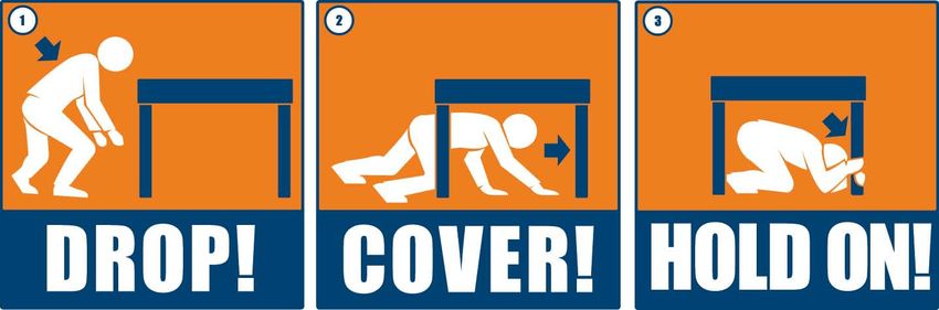
What is a tsunami?
• A tsunami is a natural hazard consisting of a series of
  long surge-like waves generated when a large volume of
  ocean water is rapidly displaced.

• There is no way to predict if a tsunami may happen.

• Tsunami waves can keep coming for hours.

• The largest wave may be hours after the first one – stay
  away from the shore until local government officials tell
  you it is safe to return.
Why shouldn’t I wait for an official warning if
        I feel a major earthquake?

• STRONG SHAKING IS YOUR WARNING!

• If you feel a strong earthquake that lasts for 60 seconds
  or more, or makes it difficult to stand, go to higher
  ground immediately! (Any where in the world)

• Officials may not have time to get to coastal areas to
  warn you or communications systems may be damaged
  due to earthquake.
What causes a tsunami? • Major submarine or coastal earthquakes are the cause of most tsunamis and create the biggest tsunamis, in terms of wave height at shore and the size of affected area. • Tsunamis may also be triggered by landslides, volcanoes or explosions.
What types of events could
cause a tsunami in the CRD?
There are two types of tsunamis:

• Distant Tsunami - Will not be “felt,” e.g..
  Alaska or Japan.
• Local Tsunami – Will be “felt,” Cascadia
  Subduction Zone (CSZ) or “the Big One”.
Threat from “Distant Tsunamis”

• Most of CRD has minimal threat from waves caused
  by tsunamis from distant earthquakes.
• We may see stronger than normal currents however
• The Juan de Fuca Electoral Area (Port Renfrew,
  Jordan River) however does have a significant threat
  as they face the Pacific Ocean
Tsunami Travel

• Tsunamis travel at 800kmh (500mph),
  the same as a jet plane!!
• As tsunamis across the ocean, there is no giant wave,
  you would not know you have passed over one
How will I know a distant
           tsunami is coming?
• You will generally have hours before a tsunami arrives.
• It is low risk, maximum 20 cm or 8 inch rise in water height in
  this area
• An alert is issued by authorities (WCATWC, EMBC).
• The Province and local government officials enact community
  notification procedures if necessary.
• Subscribe directly to receive WCATWC alerts:
  https://public.govdelivery.com/accounts/GOVDUSNWS/subsc
  riber/new
What are the different BC tsunami notification zones?
Tsunami Alerts:
          What do they mean?
A Watch (least serious level of alert) is issued if the danger
level is not known and you should stay alert for more
information.
An Advisory (second highest level of alert) indicates that
strong currents are likely and you should stay away from
the shore.
A Warning (most serious level of alert) indicates that an
inundating wave is possible and evacuation may be
suggested.
Local government officials will let you know when the
danger has passed.
“Felt” earthquakes may cause a
tsunami
• Lets look at tsunamis from earthquakes we
will feelEarthquake safety • Most tsunami risk in our region is from a “felt” earthquake. • Remember your earthquake safety: • If you are near the ocean, move to higher ground or inland once the shaking has stopped.
What should I do in the event of
           a tsunami?
• If an earthquake is felt, Drop, Cover and Hold
  on for 60 seconds or until after the shaking
  stops.
• Immediately go to higher ground or inland!
   – “Higher ground” in the Capital Region is
      generally 4m or 13 feet elevation above
      high tide level.
When do I Evacuate? • If you are near the ocean and feel a major earthquake lasting 60 seconds or more or it’s hard to stand, get to higher ground! • You may also notice: – A sudden rise or fall of ocean level. – A loud roaring noise from the ocean.
Where should I Evacuate From?
 • Check PrepareYourself.ca for a map to find
   out if you live, work, play or go to school in
   a potential hazard area so you can be
   prepared.
 • Move away from beaches, harbours,
   marinas, and low lying areas if you feel a
   strong earthquake.
 • Do NOT go to the beach/harbour to watch
   the tsunami, and do NOT plan on surfing
   it!!!
How long will it take for the tsunami
                to arrive?
     Location           Tsunami Arrival     Time to Maximum Maximum Water
                        Time (min)          Water level (min) level (m)
            West Coast35Alaska Tsunami
        • Renfrew
     Port                                   50 Warning Centre 3.5
            (WCATWC) has one zone that covers most of
     (entrance)
     Sooke Harbour
            coastal BC.60                   75                2.5
     (entrance)
        • Emergency
     Esquimalt  Harbour 77Management96       British Columbia 2.7
            (EMBC) will determine which of the 5 coastal
     (entrance)
     Victoria Harbour   76                  95                2.5
            BC
     and Gorge
                 zones  will receive    alerts.
        • Residents of the capital region can be in zones
     Waterway
     (Entrance)
            C, D, or E.
     Cadboro Bay        90                  160               2.0
     Sidney             110                 150               2.0

Reference: Capital Regional District Modeling of
Potential Tsunami Inundation Limits and Run-Up
Magnitude 9 Earthquake
• How long till the tsunami arrives and how high will it
be?
• Esquimalt Lagoon
Arrival 77 minutes, height 2.7 meters
Maximum height in 96 minutes
Cole Island
Height 3.1 metersChannelling of water • As channels/harbours narrow and get shallower the wave will increase in height
Coberg Peninsula

• The wave will cross the peninsula, and pick up logs
  and other material, and carry it into the Lagoon
• The wave height inside the Lagoon will be 2.3 meters
• The waves will inundate properties on the inside of
  the Lagoon and deposit debris from the peninsula
How should I Evacuate?
• Evacuate immediately on foot or bicycle to an area
  outside the tsunami hazard area (check map,
  generally 4m or 13 ft. elevation above high tide
  level).
• Keep roads clear for emergency vehicles - use a car
  only if absolutely necessary.
• It is NOT necessary to go to the highest point in the
  area.
How Long Should I Evacuate For?
 • Return to the evacuated area only when local
   government officials tell you it is safe to return.
 • Waves can arrive for hours, so it may not be safe
   to go back even after the first wave has arrived.
 • Large aftershocks can also generate additional
   waves.
What does tsunami modeling tell us?
  • An idea of where we are most at risk and
    the types of planning we should do.
  • What we might expect in a specific,
    significant event.
  • How the tsunami moves through the region.
What does the tsunami “hazard
area” mean?
• The tsunami hazard area is below the projected
inundation (flood) line where we expect water
to come up onto shore, and gives us an idea of
areas that may be at risk of tsunami flooding in
the Region.Where can I go to find out if I’m in a tsunami hazard area? • Go to PrepareYourself.ca to view a map of the area, or contact your local emergency program. • This area above the line gives a guideline to help determine a safe distance away from any tsunami wave run-up onshore, usually 4m or 13ft elevation above high tide level.
How is this map different than
    the one from 2004?
• This map was created with updated science and
  GIS data using the Neowave model.
• The map does not differ largely from the
  original, but confirms planning zones already in
  place.
How accurate is the modeling? • It is based on many variables, looking at maximum probable results. • Science is constantly being upgraded. • The Neowave model has proven accurate when tested against actual events. • The model is meant to provide a guideline for emergency planning and to help the public understand where safe areas are likely located.
Mapping
•   Mapping will be available from your local
    emergency program or on PrepareYourself.ca
Tsunami Safety If you are near the ocean, the most important things to do if you feel an earthquake lasting 60 seconds or more, or it makes it hard to stand: • Drop, Cover and Hold On for 60 seconds. • Move to higher ground immediately ( generally 4m or 13ft elevation above high tide level).
Where can I get more information?

   • PrepareYourself.ca
   • Your local emergency program
What can I do?
• Get involved in your community emergency
  program.
• Know your neighbours.
• Be familiar with where the tsunami hazard areas
  are located and where safe areas are to
  evacuate.
• Have emergency kits for all family members,
  including pets.
• Learn more about emergency preparedness and
  risks in the Region at PrepareYourself.ca.
Wide Area Mass Notification
           System-DND
• DND is installing “Tsunami Sirens” to warn it’s
  employees of emergencies
• These devices will sound a siren, followed by a
  voice message
• The use of these sirens will be controlled by
  the Rescue Coordination Centre in Dockyard
Locations • Initial installations will be at – Dockyard – Naden – Colwood Supply Depot – Workpoint
Additional Locations Phase 2

• Additional sirens may installed within the next
  couple of years including
  – Rocky Point
  – 443 Squadron (Victoria Airport)
  – Albert Head
Use of Sirens

• The sirens may be used all at once in an event
  like a tsunami, siren then voice message
• Each site may be operated separately, siren
  then voice message e.g.. Hazmat spill
• Sirens will be tested regularly
Affect on Colwood

• Our residents and visitors will hear them
  which may result in
  – 911 calls to fire and police
  – Calls to City Hall/Fire Hall enquiring about the
    sound
  – Public enquiries (counter)
Shake, shake, shake, shake, shake,
Drop, Cover, Hold on
Shakeout,
10:17 on 10-17Questions? Emergency Program City of Colwood
You can also read