TSUNAMI WARNINGS AND ADVISORIES - A PUBLIC INFORMATION GUIDE - January 2022 - Emergency ...
←
→
Page content transcription
If your browser does not render page correctly, please read the page content below
TSUNAMI WARNINGS
AND ADVISORIES
- A PUBLIC INFORMATION GUIDE -
January 2022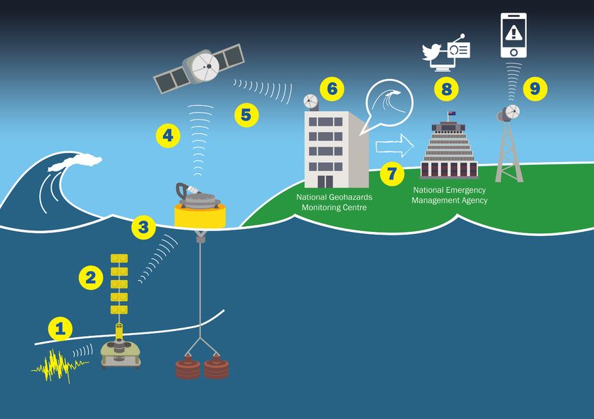

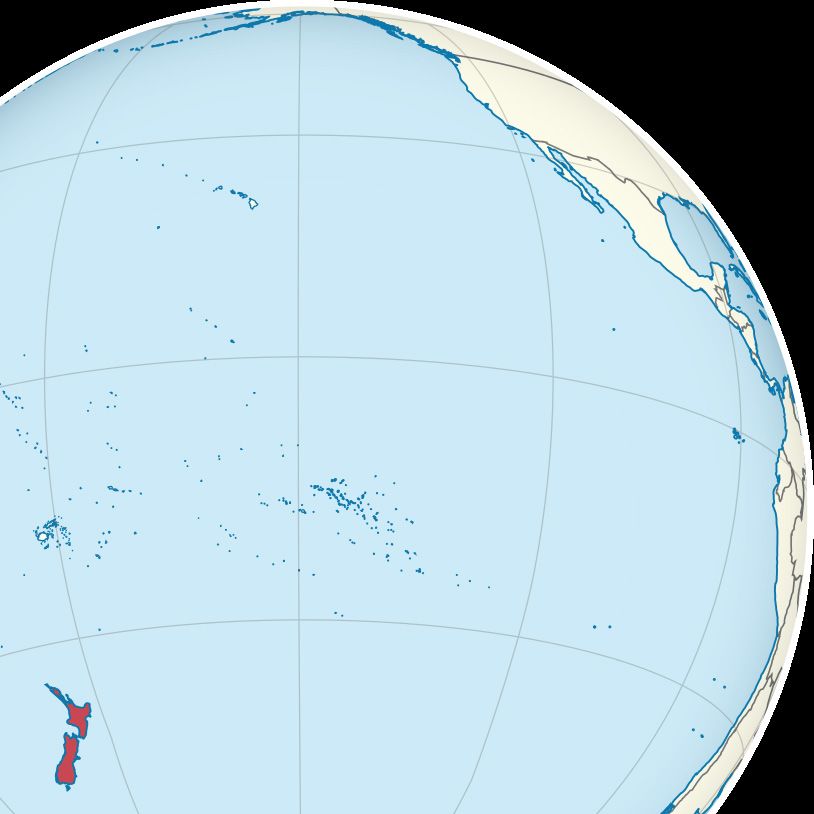
Tsunami that affect New Zealand may be generated on,
near, or far from our shores.

New Zealand is at risk from tsunami that happen near us, and around
the Pacific.

We know from geological evidence that our coasts have experienced
many large tsunami before human settlement, and some smaller but
still damaging tsunami since people arrived here.

We now live, work and play all along the coast. The likelihood of tsunami
is as clear and present as it ever was — we just haven’t had any really
big ones since New Zealand became a relatively populous country.
Tsunami are unpredictable...

A tsunami is most likely to be caused by an earthquake that moves the sea floor*.
No-one can predict exactly when or where earthquakes will happen, and how big
they’ll be.

We know a lot about specific tsunami source areas around the Pacific that have
caused tsunami in the past, including some that run through and near New Zealand.

But events such as the earthquake and tsunami that occured on 14 November
2016 show us there is still a lot to learn. They also show us that assessments about
tsunami threat can change, as more data about the earthquake’s characteristics
becomes available over time.

    *note

              Tsunami can also be caused by volcanic activity, underwater
              landslides, or landslides into water.
...but are also (in a way) predictable. We know earthquakes happen, and we know some of them will cause tsunami. We also know that some of these future tsunami (regardless of where in the Pacific they may be generated) will affect New Zealand. Once a tsunami has been confirmed, scientists have the expertise to estimate where and when tsunami activity may affect New Zealand’s coasts. ‘Tsunami activity’ may mean unusual, dangerous swells or currents at beaches and coastal waters. Or, more seriously, it may mean waves that inundate the land. Given enough time and confirmed data, it’s possible to estimate what sort of tsunami activity we can expect. If waves are likely, scientists can estimate a range for how big they might be.
GNS SCIENCE
                                    Our friends at GNS Science’s National
                                    Geohazards Monitoring Centre examine
                                    and review earthquake and tsunami-
                                    related data, and determine what it
                                    means for New Zealand.

                                    Scientists from other organisations assist
                                    GNS Science by participating in the
                                    Tsunami Experts’ Panel.

WHO ARE THE
SCIENTISTS?
                            REMEMBER

              GNS Science are our go-to experts regardless of where tsunami
              are generated. This is because GNS Science is a New Zealand-
              based organisation. Only they have the necessary depth
              and breadth of local scientific knowledge required to make
              informed estimates of a tsunami’s effect on New Zealand.

              Information that comes from international agencies (such
              as the Pacific Tsunami Warning Centre (PTWC)) is always
              examined as part of the assessment process — but data from
              international agencies should never be presented as definitive
              for New Zealand.
tsunami Warnings and advisories
The National Emergency Management Agency (NEMA) is the
official agency for providing tsunami advisories and warnings.
Using information from our GNS Science partners, we issue
these advisories and warnings to regional Civil Defence
Emergency Management Groups (CDEM Groups), local
government, a wide range of agencies, the media and the
public.
WHERE DOES
NEMA FIT IN?
REMEMBER
Only advisories and warnings issued by NEMA represent the
official threat status for New Zealand, as we use information
confirmed by GNS Science.
Information from international agencies (e.g. PTWC, or the
United States Geological Survey (USGS)) should never be
presented as definitive for New Zealand.CDEM Groups and CDEM Group members are responsible for
the planning, development, and maintenance of appropriate
public alerting and tsunami response systems, including public
education and evacuation zone identification for their areas.
All CDEM Groups and CDEM Group members receive official
WHAT ARE national tsunami advisories and warnings. When time and
expertise is available, CDEM Groups are responsible for further
local threat assessment and advising the public which local
CDEM GROUPS
areas or zones should be evacuated in their regions, or which
marine areas and coasts are off limits.
RESPONSIBLE
FOR? REMEMBER
NEMA can only ever identify very broad areas for evacuation.
We can’t issue evacuation advice for specific locations.
CDEM Groups and local councils will have the information
about which tsunami zones are being evacuated in their areas
of responsibility, or which specific coastal areas are off limitsAssessing tsunami activity and providing accurate, timely warnings
depends on distance. A tsunami coming from far away gives GNS
Science time to gather confirmed data and assess the tsunami’s
characteristics. The more distant the tsunami’s origin, the more
DISTANCE IS
time they have to assess it, and the more accurate that assessment
will be.
If the tsunami’s origin is far from New Zealand:
EVERYTHING •
•
GNS Science have time to assess
Assessments are based on confirmed data
• NEMA can issue more refined advice
• Communities have time to prepare and act
Unfortunately, the inverse is also
true.If the tsunami’s origin is close to
New Zealand...
• a tsunami could arrive within minutes
• communities must act immediately
• GNS Science may not have enough time to assess the
threat before the first waves arrive
• NEMA may not have enough time to issue an official
warning before the first waves arrive.
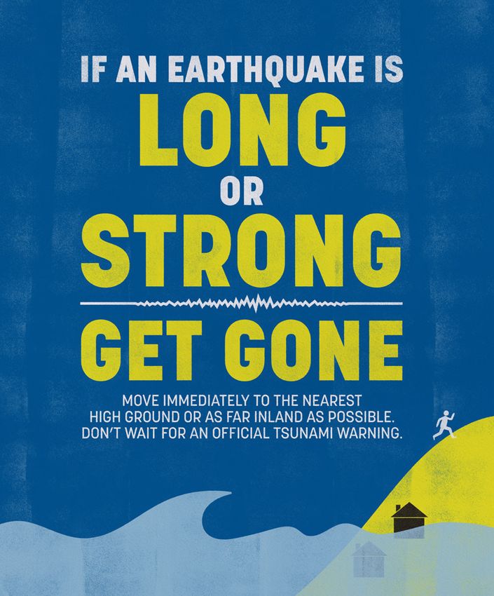
Hence: LONG or STRONG, GET GONE.If you feel a LONG earthquake that lasts more than a minute or a STRONG earthquake that makes it hard to stand, or see or hear unusual ocean behavior, move immediately to the nearest high ground, out of tsunami evacuation zones, or as far inland as possible. Don’t wait for an official warning. “Long or Strong, Get Gone” is the best advice for people near the coast after a large, strongly-felt earthquake. We encourage media to share the “Long or Strong, Get Gone” message with audiences if an earthquake of this sort occurs, even if no detailed information is yet available.
WHAT IS A LOCAL-SOURCE TSUNAMI?
          A local-source tsunami is one that is generated close to New
          Zealand’s coastline.

          Scientific information for a local-source tsunami is often uncertain
          at first. It takes time to assess whether a tsunami has been
          generated, so there may not be time for an official warning. If
          people experience the natural warning signs, they need to act
          immediately — that’s why it’s all about “Long or Strong, Get Gone”.

TSUNAMI
          It’s important to remember that, in a local-source situation, New
          Zealand communities may have experienced the primary effects
          of the earthquake. This means there may be injuries and damage
          to buildings. It also means roads, bridges, power supplies, and

SOURCES   communications networks may have been affected.

          Local-source tsunami may also be caused by volcanic activity,
          underwater landslides, or landslides into water.

          WHAT IS A REGIONAL OR DISTANT-
          SOURCE TSUNAMI?
          A regional or distant-source tsunami is one that is generated at
          least one hour’s travel time from New Zealand.

          In a regional or distant-source situation, New Zealand communities
          are likely to have been spared the primary effects of the earthquake.
          Although the tsunami itself may be dangerous and destructive,
          there will be some time to warn people before the first waves arrive.
The warning process and the messages we send are different for local-source tsunami and tsunami from further away (regional and distant-source tsunami). Regardless, you can help us save lives by sharing the right messages with your audiences.
OUR PROCESS
    REGIONAL AND DISTANT-SOURCE TSUNAMI

1                                         4                                               5   For regional and distant source tsunami, there
    New Zealand receives                                                                      is more time for assessment of possible local
                                              GNS Science determines the severity
    notification of a possible tsunami                                                        impacts. CDEM Groups are responsible for further
                                              of the threat and informs NEMA. NEMA
    threat from the Pacific Tsunami                                                           local threat assessment and for advising which
                                              issues an advisory or warning based
    Warning Centre (PTWC). This                                                               local areas or zones should be evacuated in their
                                              on this. A tsunami threat level map will
    notification goes directly to                                                             regions (National Warning: land and marine
                                              accompany a warning.
    NEMA and GNS Science.                                                                     threat), or which marine areas and coasts are off
                                              National Warning: LAND AND                      limits (National Advisory: tsunami activity). They
2                                             MARINE THREAT                                   will advise the media and the public.
                                              Tsunami waves are expected to affect the
    NEMA will rapidly send out a
                                              land. A land and marine threat means
    “Large Pacific Earthquake Being
    Assessed” advisory to let everyone
                                              that evacuations will be required.
                                                                                          6   If there is a land and marine threat, NEMA
                                              National Advisory: TSUNAMI
    know we are checking whether                                                              will send an Emergency Mobile Alert to
                                              ACTIVITY
    there is a threat to New Zealand.                                                         all capable mobile phones in the areas
    Remember that this advisory is            There is a threat to beach and marine           under threat. CDEM Groups will also send
    not the same as confirmation of a         areas. The tsunami is likely to cause           supporting Emergency Mobile Alerts
    tsunami threat for New Zealand.           strong and unusual currents and                 providing local evacuation information.
                                              unpredictable surges at the shore.
                                              People should stay off beaches and out
3   GNS Science tsunami experts               of the water.                               7
    review the available information to       National Advisory: NO TSUNAMI                   If a National Warning or National Advisory:
    determine what it means for New           THREAT TO NEW ZEALAND                           Tsunami Activity is issued, it will remain in effect
    Zealand. This will include looking                                                        until GNS Science advises that the threat has
                                              There is no tsunami threat to our coasts.
    at DART (Deep-ocean Assessment                                                            passed. This may take as long as 24 hours, as
    and Reporting of Tsunami) buoy                                                            tsunami waves and currents can be dangerous long
    data and tsunami modelling to help                                                        after the first waves arrive. When NEMA receives
    determine the most likely scenario.                                                       this confirmation, we issue a cancellation message.
NATIONAL ADVISORY: LOCAL EVACUATION
REMEMBER TSUNAMI ACTIVITY INFORMATION NEEDS TO
Beach and marine threats are unlikely to COME FROM THE CDEM
require any evacuations (besides getting GROUP
PLEASE SHARE OUR people off beaches). Strong and unusual NEMA can only ever identify very broad areas
currents and unpredictable surges are
MESSAGES for evacuation. We can’t issue evacuation
obviously dangerous for people in or on advice for specific locations. CDEM Groups
Please share the messages we issue and beaches and coastal waters, but people on dry
any relevant local information through and local councils will have the information
land don’t need to worry about waves reaching about which tsunami zones are being
all your channels as quickly as you can. them.
We want to reach as many people as evacuated in their areas of responsibility, or
possible. Remember that information from which specific coastal areas are off limits.
It’s extremely important that we get the strong
international agencies (including PTWC) currents and surges information out there,
should not be presented as definitive for New but generally this type of threat should be INFORMATION CAN
Zealand. If the situation is serious enough we positioned as ‘low risk’ for anyone not actually CHANGE
will officially request our broadcast media in the water or at the beach. GNS Science experts make their
partners (who are identified in our MOU with determinations based on the data available
broadcasters) to broadcast the emergency TIMING at the time. But information develops,
information at regular intervals until we issue and situations can change. Thankfully, in a
Some tsunami warnings and advisories may
a cancellation. regional or distant-source situation, there
have a long lead-in time, i.e. it may be as much
as 12 hours before tsunami activity affects our should be enough time to recalibrate and
NATIONAL WARNING: LAND coasts. issue revised advice.
AND MARINE THREAT
Land and marine threats are as serious as
This means communities need to be absolutely WHEN WE KNOW, YOU’LL
clear about timing, as well as the appropiate
our warnings get. A land and marine threat KNOW
safety advice. For example, if we know at
means that tsunami waves are coming, and Information becomes clearer, more reliable,
8pm in the evening that tsunami activity is
will reach inland. A Land and Marine Threat and more specific as time passes. Bottom
due to begin at 6am the next morning, this
will usually mean evacuation for at least line — once we have confirmed information,
information needs to be shared ASAP and
some areas. we will give it to you straight away.
throughout the evening, to ensure that anyone
Always remember that the first tsunami who’s going to be on the water the next day can
waves may not be the largest. cancel their plans.OUR PROCESS
NEMA will rapidly send out an “Earthquake Being
LOCAL-SOURCE TSUNAMI Assessed” advisory to CDEM Groups and the media, to let
everyone know we are checking whether there is a threat to 5
1 3 New Zealand. Remember that this advisory is not the same
If there is a land and
A very large earthquake near the marine threat, NEMA will
as confirmation of a tsunami threat for New Zealand.
coast (or, less likely, an offshore send an Emergency Mobile
volcanic eruption/landslide) Alert to all capable mobile
happens. We won’t know whether phones in the affected
NEMA issues a National Warning or Advisory based on available
a tsunami has been generated areas. CDEM Groups will
data.
until DART buoys or coastal 4 also send supporting
National Warning: TSUNAMI THREAT
instruments detect waves, or Emergency Mobile Alerts
people see tsunami waves. If the earthquake is very large, and/or located near a known providing local evacuation
dangerous tsunami source (off the East Coast of the North information.
Island), NEMA will issue a “National Warning: Tsunami Threat”
2 stating “Long OR Strong, Get Gone”.
Anyone near the coast who feels We may send this warning before GNS Science can provide a
the earthquake LONG (more than 1 detailed assessment — even if we don’t know whether a tsunami 6
minute) or STRONG (hard to stand has been generated. This first warning may arrive after the first If a National Warning is
up), or sees or hears unusual ocean waves. issued, it will remain in
behaviour must evacuate immediately. effect until GNS Science
Our tsunami warning may have an action map attached, which
We don’t want anyone to advises that the tsunami
indicates broad areas for evacuation. These maps are prepared
threat has passed. This
wait for an official warning based on modelling.
may take as long as 24
of any kind. IF IN DOUBT, GO. National Advisory: NO TSUNAMI THREAT TO NEW ZEALAND hours, as tsunami waves
These will always be the key If GNS Science determines there’s no threat to our coasts, NEMA and currents can be
messages for local-source issues a “No tsunami threat for New Zealand” advisory. Bear in dangerous long after
tsunami, regardless of any mind that communities may be dealing with the earthquake’s the first waves arrive.
aftermath, including possibly severe damage and aftershocks. When NEMA receives this
new systems or technology
NEMA will work with CDEM Groups to figure out what the confirmation, we issue a
the future brings. situation is on the ground, and what help is needed. cancellation message.The best things you can do to help us are:
REMEMBER 1. Push the “Long or Strong, Get Gone”
message.
2. CDEM Groups and the public should
LOCAL-SOURCE TSUNAMI THE CHALLENGE FOR GNS not wait for an official warning from
ARE A BIG DEAL SCIENCE AND NEMA NEMA if long or strong shaking is felt.
Take immediate action to evacuate
Local-source tsunami can arrive within minutes Local-source tsunami are challenging.
predetermined evacuation zones, or in
at areas closest to the source, and New We have to make rapid decisions in highly
the absence of predetermined evacuation
Zealand has some local tsunami sources (e.g. uncertain situations. Instruments can detect
zones, go to high ground or go inland.
the Hikurangi Trench) that can produce very earthquakes, but cannot confirm whether a
large, life threatening tsunami. tsunami has been generated until DART buoys 3. Keep watching your email and NEMA’s
detect changes in water pressure or waves hit website and social media accounts.
TSUNAMI ACTION MAPS ARE the coastal tsunami gauges. That’s where the latest, official
BROAD INDICATORS It can also be difficult for scientists to
information will be sent when it is ready.
The maps indicating evacuation areas we determine the exact location and size of very 4. Publish and share our messages along
may issue for a local-source tsunami warning large earthquakes in the first few minutes, with any relevant local information
are conservative. They show black areas because the shaking can overwhelm monitoring through all the channels you have. This
which NEMA advises should be evacuated instruments. We need a scientist to interpret includes tsunami maps.
immediately, and shaded areas which are the data and make sense of it. This takes time.
under assessment (noting that ‘Long or Strong, 5. Remember that our officials will be
Get Gone’ still applies to all areas — both WE NEED LOCAL SUPPORT 100 per cent focused on issuing safety
black and shaded). messages and assessing the ongoing
MORE THAN EVER
threat. Please be understanding if we
In issuing these maps, there’s always a risk of If there’s a large earthquake that looks like it’s
can’t grant you requests for information
overstating the threat to some areas. But in in local-source tsunami territory (due to its
right away. Rest assured, all we know
these situtations, we only have preliminary magnitude and location), we need you to help
(and all the information you’ll need during
data to go on (if any), and we just can’t afford us keep people safe.
the initial stages of the event) will be
the time it takes refine the advice.
appearing ASAP in your email and on our
social media.THERE’S NO SILVER BULLET...
No single process or piece of technology will ever be able to provide
a 100 per cent failsafe way to warn the public about local-source
tsunami.
An effective overall warning system involves many people and many
tools. GNS Science, NEMA, and CDEM Groups work constantly to
NOTHING WILL build knowledge of tsunami, develop modelling and tools, enhance
processes, and improve warning messages.
EVER BEAT ...BUT THERE IS A GOLDEN RULE
No matter what systems or technology we develop, nothing will
'LONG OR ever beat this golden advice for a local-source tsunami:
Long or Strong, Get Gone.
STRONG, GET
Anyone near the coast who feels the earthquake
LONG (more than 1 minute) or STRONG (hard
to stand up), or sees or hears unusual ocean
behaviour must evacuate immediately.
GONE' If people know and understand ‘Long or Strong, Get Gone’, it won’t
matter if the earthquake has knocked out the cell towers, or cut
power to tsunami sirens.
People in the areas most likely to be affected by the tsunami - i.e.
those areas where the earthquake was felt LONG or STRONG - will
know exactly what to do.EMERGENCY MOBILE ALERT
If there is a tsunami Emergency Mobile Alerts are messages about emergencies sent
threat to land and marine by authorised emergency agencies to capable mobile phones. The
alerts are designed to keep people safe and are broadcast to all
capable phones from targeted cell towers.
areas, NEMA will send an The alerts are targeted to areas affected by serious hazards and
Emergency Mobile Alert to will only be sent when there is a serious threat to life, health or
property, and, in some cases, for test purposes.
all capable mobile phones Depending on how far away the tsunami is, we’ll send an Emergency
Mobile Alert to phones in the areas under threat telling people to
in the areas under threat. EVACUATE IMMEDIATELY or to PREPARE TO EVACUATE (if the first
waves aren’t expected to arrive for several hours).
Local CDEM Groups will also issue an
Emergency Mobile Alert
CDEM Groups will have the information about which tsunami
zones are being evacuated in their areas of responsibility, or which
specific coastal areas are off limits. They will send a supplementary
Emergency Mobile Alert to the areas under threat providing more
detailed local evacuation information.
Don’t wait for an alert if the earthquake is
LONG or STRONG
Emergency Mobile Alerts do not replace the need to take action
after natural warnings. For a local source tsunami, which could
arrive in minutes, there won’t be time for an official warning. It is
important that people recognise the natural warning signs and act
quickly.NO NEED TO SUBSCRIBE WHO CAN SEND AN ALERT? WILL EMERGENCY MOBILE
There is no need for people to sign up or Emergency Mobile Alert messages can only be ALERT WORK IF CELL
download an app. If a phone is on and sent by the National Emergency Management PHONE TOWERS ARE
capable of receiving them, it should get the Agency, Civil Defence Emergency Management DAMAGED, OR IF THERE IS
alerts. People can check whether their phone Groups, NZ Police, Fire and Emergency New
A POWER OUTAGE?
can receive the alerts at getready.govt.nz Zealand, the Ministry of Health and the
and should ensure their phone is on the most Ministry for Primary Industries. Emergency Mobile Alert may not work if
up to date operating system. mobile phone towers are damaged or if there
is a power outage.
DON’T DITCH THE RADIO
WORKS BY GEO-TARGETING Emergency Mobile Alert is an additional Emergency Mobile Alert is an additional
Emergency Mobile Alerts will be targeted to channel to help keep New Zealand safe in an channel to help keep people safe in an
areas under threat only. People outside the emergency and does not replace other alerting emergency and does not replace other
targeted broadcast area won’t receive the channels such as radio and social media, or alerting systems or the need to take action
alert. the need to take action after natural warnings. after natural warnings.
If you feel your life may be in danger, don’t wait
YOU CAN’T OPT OUT for an official warning. Take immediate action. WILL EMERGENCY MOBILE
Remember – Long or Strong, Get Gone.
As Emergency Mobile Alert is about keeping ALERT WORK EVERYWHERE
people safe, it isn’t possible to opt-out. IN NZ?
Some phones may show optional settings Emergency Mobile Alert should work in areas
used in other countries, but in New Zealand with cell reception. About 97% of populated
we use a special broadcast channel that is areas get cell reception and work is being
permanently on. done by the mobile service operators to
improve mobile coverage all the time.TSUNAMI
WHAT IS A DART BUOY?
DART (Deep-ocean Assessment and Reporting of Tsunami) buoys
are deep-ocean instruments that monitor changes in sea level.
MONITORING They are currently the only accurate way to rapidly confirm a
tsunami has been generated before it reaches the coast. Early
AND DETECTION
detection of a tsunami using DART buoys allows us to accurately
provide early warnings using a range of communication channels
including Emergency Mobile Alerts.
NETWORK HOW DO DART BUOYS WORK?
DART buoys detect tsunami threats by measuring associated
While Long or Strong, Get Gone is still the best action to take to changes in water pressure via sea floor sensors. They are capable
stay safe, not all tsunami that could affect New Zealand come of measuring sea-level changes of less than a millimetre in the
from earthquakes that people will feel. Because of this, being deep ocean. Two-way communication between a DART buoy and
able to detect tsunami waves while they are in the deep ocean is GNS Science’s 24/7 National Geohazards Monitoring Centre allows
very important. This is particularly critical for unfelt earthquakes rapid assessment of threats and enables subsequent warning
originating from the Kermadec trench. advice to be provided to the public.
New Zealand’s end to end arrangements for monitoring, detecting
and issuing warnings about tsunami include a network of DART
(Deep-ocean Assessment and Reporting of Tsunami) buoys
to provide early detection and support warnings for tsunami
generated from the Kermadec and Hikurangi trenches and Pacific
sources further away.
Not all sea floor disturbances, such as underwater earthquakes,
cause tsunami. The DART buoys also provide rapid confirmation
when no tsunami has been generated following large earthquakes
and other possible “trigger” events in the ocean.END TO END
PROCESS FROM
SEAFLOOR
TO TSUNAMI
WARNING
1. An undersea event (earthquake, volcanic eruption, landslide) occurs.
2. A sensor on the ocean floor detects significant changes in water pressure.
3. The data is sent by acoustic signal to a buoy on the surface.
4. The buoy sends the signal to a satellite.
5. The signal is sent to the 24/7 National Geohazards Monitoring Centre based in Lower Hutt.
6. Geohazard experts analyse the data.
7. If a tsunami has been detected, the National Geohazards Monitoring Centre will notify the
National Emergency Management Agency.
8. The National Emergency Management Agency will issue a tsunami warning directly to the
public via their website and Twitter and to CDEM Groups, emergency services and media.
9. If the tsunami is expected to inundate (flood) land areas, an Emergency Mobile Alert will
be sent to all capable mobile phones in the affected areas.TSUNAMI SIRENS The decision to use sirens and their ongoing maintenance is the responsibility of CDEM Groups and local authorities. If CDEM Groups and territorial authorities do choose to install tsunami sirens they need to comply with the Tsunami Warning Sirens Technical Standard (available at https://www.civildefence.govt.nz/ resources/tsunami-warning-sirens/). It is important to recognise that sirens are only one component within a wider warning system, and sirens have a number of disadvantages. Local source tsunami, where the earthquake has occurred close to New Zealand’s coastline can arrive within minutes at areas closest to the shore and there won’t be time to issue an official warning before the first wave arrival, nor even activate the sirens. The sirens may also be damaged by the earthquake itself. CDEM Groups and local authorities who decide to use sirens must undertake targeted and continuous public education and awareness activities. Public education and awareness activities related to the use of sirens in tsunami warnings must promote the importance of the recognition of natural warning signs. Activation of sirens must not be expected for local source tsunami events – the long or strong earthquake is the only reliable warning.
MORE INFO

PLANNING FOR                                  ALL ABOUT TSUNAMI                         MOU WITH
EMERGENCIES AND                               www.getready.govt.nz/emergency/tsunami    BROADCASTERS
BEING PREPARED                                                                          www.civildefence.govt.nz/media/
www.getready.govt.nz                                                                    memoranda-of-understanding-mou-with-

                                              TSUNAMI                                   radio-and-tv-broadcasters

                                              EVACUATION ZONES
HOW TO CONTACT
CDEM GROUPS                                   www.getready.govt.nz/emergency/tsunami/
                                                                                        MEDIA CONTACTS
www.civildefence.govt.nz/find-your-civil-     tsunami-evacuation-zones
                                                                                        www.civildefence.govt.nz/media/local-
defence-group
                                                                                        regional-media-contact-information

ABOUT CDEM                                    GUIDELINES
                                              AND TECHNICAL
www.civildefence.govt.nz/cdem-sector/
plans-and-strategies/guide-to-the-national-
                                              STANDARDS
civil-defence-emergency-management-plan       www.civildefence.govt.nz/cdem-sector/
                                              guidelines
THANK YOU for helping us keep New Zealanders safe.
You can also read