Understanding oceans in change: Engineering science and technological tools for distributed real-time sensing - Kristin Guldbrandsen Frøysa, CMR ...
←
→
Page content transcription
If your browser does not render page correctly, please read the page content below
Understanding oceans in change: Engineering
science and technological tools for distributed
              real-time sensing
      Kristin Guldbrandsen Frøysa, CMR and University of Bergen
      Anne A Hageberg, CMR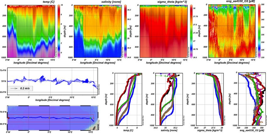
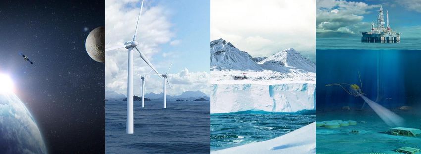
Christian Michelsen Research’s main markets

         Oil & Gas        Environment and Marine

                                            Illustration by ESA

     Renewable Energy               Space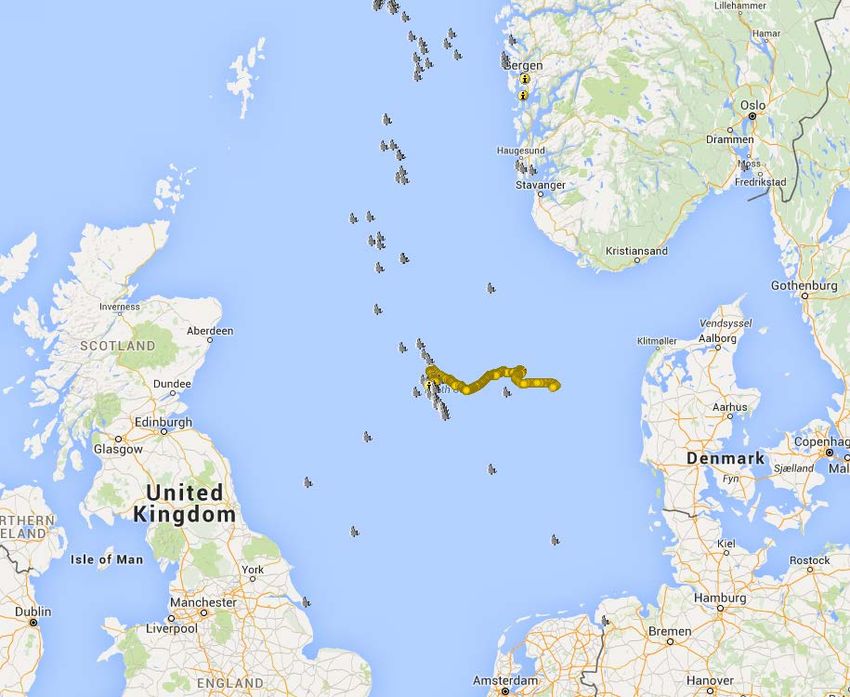
Observing the marine environment
Environmental Observations
Develop solutions for reliable operation in extreme environments, including
- Buoys, Autonomous measurement platforms and sensors
- Low power consumption Long term operation
Marine Resources
In collaboration with Institute of Marine
Reserach (Norway), develop advanced scientific software and analysis tools for
mapping pelagic and demersal resources
Aquaculture and Fisheries
Develop:
- Sensors for fish welfare, water quality and biomass
- Decision support for fishing vessels and marine spatial planning
3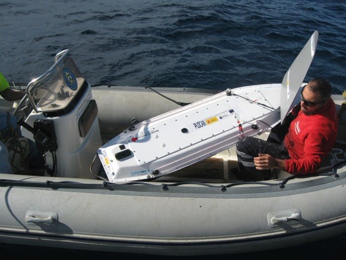
Fish stock detection

Advanced software and analysis tools
    -   Mapping the pelagic and demersal resources

LSSS                                          SEAT
- For marine stock assessment / research       - Real-time system for fishing vessels
- Post-processing of acoustic data             - Decision support during search/capture
- Designed for experts in underwater acoustics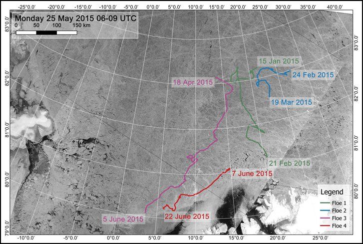
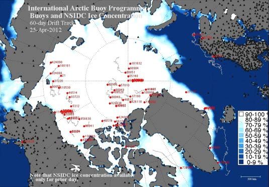
Real-time data of ice drift and weather

• Yearly deployment of the ICEX buoy since 1995
• Part of an international programme (IABP) for collection of real-time
  data of weather observations and movement of ice in the Arctic
• Air pressure, temperature and position
• Air deployable
From drifting buoys to planned cruises: ‘SailBuoy’

•   2m long, 15kg payload
•   Precise temporal & spatial sampling rate
•   Dynamic cruise planning
•   On-line, < 1 minute round trip communication
•   Tested in North Sea and the Barents Sea, Mexico Gulf
•   Commercially available www.sailbuoy.no

The Sailbuoy

The Sailbuoy – Autonomous surface vehicle / platform
   -   Developed by CMR. Commercial available through Offshore Sensing AS
   -   A wind driven platform (use wind for propulsion, behaves much like a sailboat)
   -   Power for electronics and actuators (battery and solar panels)
   -   Data communication and control (real time using Iridium satellite)

Target – offer new services:
   -   Measurement and data collection
   -   Subsea communication
   -   Surveillance and warning

Target – reduced costs
   -   Reduce needs for vessels
       with high rates
Wave mission at Ekofisk
    Deployed by R/V Håkon Mosby 30 October 2015 for 3 weeks.   SB Wave track
    Wind 3-22 m/s Waves 2-13m

                                              Waverider buoy    Ekofisk oil field
Courtesy: Met.no/Offshore Sensing
Waverider/SB Wave comparison

Courtesy: Met.no/Offshore Sensing
‘SailBuoy’: Use of autonomous
                    measurements
                             • 81°N, north of arctic archipelago of
                               Spitzbergen (2013)
                             • Waveheight measurements (SailBuoy)
                               close to ice edge
                             • NERSC (ice waves vs. ocean waves)
                             • Improvement of forecast models (MET)

                             • Gulf of Mexico: Surface temperature,
                               salinity and oxygen (SailBuoy)
                             • Example w/Deep-C
                             • Data input to models predicting surface
                               conditions (outlet of Missisippi)
                             • Model parameters corrected!
Courtesy: Offshore Sensing
Summer Ice Edge Cruise 2016
• In the summer of 2016, two Sailbuoys will be deployed in
the area around the ice edge
• In a collaboration project between Offshore Sensing,
Aanderaa, CMR and Nansen Environmental and Remote
Sensing Center (NERSC), the vessels will be utilized to
look at the processes around the ice – ocean interface
• One Sailbuoy will be mounted with O2, pH, pCO2,
Conductivity and temperature sensors
Sailbuoy routes will be planned • The other Sailbuoy will utilize a mounted ecco sounder to
Using satellite data from the area collect back scatter data
close to the ice-edge
• Satellite data will be utilized for navigation purposes to
ensure the vessels are guided to the most scientific
interesting areas
• Scientific analysis will be done by NERSC
Sailbuoy with ecco sounder and sailbuoy with Aanderaa Water Quality Sensors
11 Courtesy: AanderaaSailbuoy with Aanderaa Sensor Pack
• Sailbuoy offers a unique method to gather
data in remote locations
• In the Iskantseilas (Ice Edge) project, we
wanted to utilize this platform to test out
Aanderaa’s new range of sensors: optical pH
and optical pCO2
• The Sailbuoy with the Aanderaa sensor pack
utilizes a bulb mounted design
• The sensor pack can include: O2, pH, pCO2,
Conductivity, Temperature and turbidity
from Aanderaa
• Fouling is avoided using a UV light Sailbuoy with Aanderaa sensors
and UV light in kiel
• A wide range of sensors from other vendors
can be fitted by mounting them in the vessel
hull
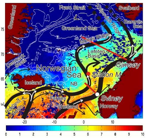
Courtesy: Aanderaa/Offshore SensingNorwegian Atlantic Current Observatory (NACO)
National research infrastructure facility since 2011
Hosted by University of Bergen
Operation central
ftp
Data centre Models, ...
NACO launch, minister Tora Aasland
1000m
20-40 km/day horisontally
Courtesy: Peter M Haugan, UoBNACO =
1. A real time
mooring at Svinøy
2. A national
facility for gliders
to provide services
also outside
NACO area. Build-
up funded by
Research Council,
use by projects.
Run by GFI/UiB with IMR and
Runde Environmental Centre as partners
Courtesy: Peter M Haugan, UoBNACO: 6 Seagliders and 3 Slocums, > 40 000 km since 2012
No loss of equipment
Applied to projects in Norwegian Sea, Faroe-Shetland,
fresh water, coastal and fjord areas, Svalbard, Iceland
Piloting tool: Gliderpage developed at
Geophysical Insitute, UiB
• Web client based on Google Maps API v.3
• Integration between Google Maps and open wms
map data from statkart.no/geonorge.no, weather
data from met.no/yr.no etc.
• Integration between map application and technical
matlab plots, communication with base station for
editing of cmdfile/science/target, copy of data- and
logfiles, monitoring of technical condition of glider.
Courtesy: Peter M Haugan, UoBCourtesy: Peter M Haugan, UoB
Typical standard section data

Courtesy: Peter M Haugan, UoB
More information

•   Christian Michelsen Research: www.cmr.no
•   Sailbuoy: www.sailbuoy.no
•   Aanderaa: www.aanderaa.com
•   Peter M Haugan’s presentation of gliders:

    – http://www.asuf.no/wp-content/uploads/2016/05/S1_3_Peter_Haugan.pdf

• NACO - Norwegian Atlantic Current Observatory
    – http://naco.gfi.uib.no/

• Contact information: kristin@cmr.no
You can also read