Unexpected Journeys with the HOBBIT - The Design and Evaluation of an Asocial Hiking App
←
→
Page content transcription
If your browser does not render page correctly, please read the page content below
Unexpected Journeys with the HOBBIT –
          The Design and Evaluation of an Asocial Hiking App
                Maaret Posti                                            Johannes Schöning                                Jonna Häkkilä
           CIE, University of Oulu                                Hasselt University – tUL - iMinds                   University of Lapland
          Erkki Koiso-Kanttilan katu                                     Wetenschapspark 2                    Faculty of Art & Design, Laajakaista 3
             90014 Oulu, Finland                                     3590 Diepenbeek, Belgium                       96400 Rovaniemi, Finland
             maaret.posti@cie.fi                                  johannes.schoening@uhasselt.be                    jonna.hakkila@ulapland.fi

ABSTRACT
In the age of mobile communications and social media,
users are connected to interact with other people, and often
obliged to be socially active as technology drives to connect
us. In this paper, we harness the technology for the opposite
use: helping people to avoid company instead of
encouraging interaction. We have developed the concept of
an asocial hiking application (app), in which users can
generate routes that avoid meeting other people. We
developed the concept based on user feedback data derived
from an online survey (n=157) and two focus groups, and
created a tool that generates solitary hiking routes based on
OpenStreetMap data and additional information from the
web. In addition, to make the application react to dynamic
changes in the environment, we developed a mobile
application prototype that scans Wi-Fi signals to detect
other hikers nearby and warn of their approach. The
prototype was tested and evaluated with 8 hikers in-the-
wild. In addition to the concept design and the functional
prototype, we present findings on people’s, especially                                       Figure 1: The asocial hiking app HOBBIT in use during
hikers, need for solitude, and introduce user feedback from                                 the in-the-wild study. Users get warnings on their mobile
each stage of the prototype design process as well as design                                          device if an unknown hiker is nearby.
recommendations for an asocial navigation application.
Author Keywords
Location-based services (LBS); Hiking; Solitude; Context-                                 communications and social media applications, which lets
aware computing; Mobile devices; User studies.                                            us be connected with other people virtually always and
                                                                                          everywhere. Many mobile applications are designed to
ACM Classification Keywords                                                               exchange information between people and bring them
H.5.1 [Multimedia Information Systems]: Artificial,                                       closer together by digital means. With increased use of
Augmented, and Virtual Reality, Hypertext navigation and                                  mobile phones and ever-evolving mobile Internet access,
Maps, Location-based services (LBS)                                                       people are nowadays more connected than ever. For
INTRODUCTION & MOTIVATION                                                                 instance, smart phone users are reported to spend the
The past decade has witnessed the rapid raise of mobile                                   average of an hour daily using apps [4]. Following this
                                                                                          trend, mobile map and travel applications are one of the
                                                                                          most popular application categories in various online
Permission to make digital or hard copies of all or part of this work for personal or     application stores for mobile devices [4]. Classical location-
classroom use is granted without fee provided that copies are not made or distributed     based services (LBS) [13, 18] are taking advantage of this
for profit or commercial advantage and that copies bear this notice and the full
citation on the first page. Copyrights for components of this work owned by others
                                                                                          fact by providing more and more social services and add-
than the author(s) must be honored. Abstracting with credit is permitted. To copy         ons. These range from commercial applications such as
otherwise, or republish, to post on servers or to redistribute to lists, requires prior   Foursquare, Google Latitude, (recently merged into Google
specific permission and/or a fee. Request permissions from permissions@acm.org.
DIS 2014, June 21–25, 2014, Vancouver, BC, Canada.
                                                                                          Plus), or other friend-finding services to research prototypes
Copyright is held by the owner/author(s). Publication rights licensed to ACM.             [22, 25]. However, it has also been reported that users
ACM 978-1-4503-2902-6/14/06...$15.00.                                                     sometimes wish to be unavailable and disconnected, and
http://dx.doi.org/10.1145/2598510.2598592
                                                                                          purposefully avoid responding to communication attempts
                                                                                          [20]. In this paper, we want to more closely examine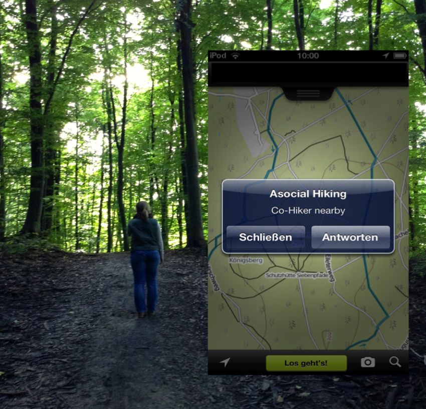
people’s wishes and behaviour on seeking solitude,              design drivers and lessons learnt for asocial navigation and
focusing on the specific context of hiking.                     further application development.
Whereas some navigation systems and concept designs             RELATED WORK
already utilize information about location or preferences of    LBS and Pedestrian Navigation Systems
other people, this information has so far been used to find     Together with the omnipresence of mobile devices, position
or gather people together, or recommend popular routes or       technology, and an increasing number and variety of mobile
points of interest (POIs) [21, 26]. In this paper, we           apps, location based services (LBS) have become
introduce the opposite approach and want to present the         increasingly popular in both research and industry. Raper et
concept of our Asocial Hiking App, which could be               al. [18] provide a thorough overview of mobile guides that
considered as a complete inverse approach to existing           rely on maps or map-like representations, and discusses
system mentioned above. Instead of connecting people and        both technical and HCI related challenges. With LBS, the
bringing them together by digital means, the goal of our        focus has very much been in use cases and UI design
mobile application is to let hikers experience solitude         solutions for wayfinding [8, 12, 14], and locating shops or
during their hikes through nature. The application enables      other POIs [5, 21], people (e.g. Google Latitude), or even
quiet hiking routes by giving the user a sign of an upcoming    cars [16], and ranging from graphical user interface (GUI)
encounter with other people. The aim is to support users        based applications to systems combining different, less
seeking solitude and the perception of being on their own       conventional interaction techniques. Examples of the latter
which are often regarded as an integral part of a hiking        include the Rotating Compass, which combines a mobile
experience in the mountains or woods.                           phone and a public display for presenting navigation
For developing the application we followed a classical user-    instructions [19] and ActiveBelt, which provides directional
centered design approach [17]. To get an overview of the        guidance through haptic feedback [27]. In addition, location
hiking practices as well as preliminary asocial hiking          has been used together with other information, such as
concept feedback, we set up an online survey (n=157) and        sensor data, to create smart applications that can react to
organized two focus group sessions with altogether 14           dynamically changing conditions [23], i.e. become context-
people. The themes and conclusions derived from the             aware [2]. Pedestrian navigation systems have been a point
studies formed the basis of the final application prototype.    of study in the HCI community for nearly two decades,
Combining data from the OpenStreetMap (OSM) project,            Cyberguide [1] and GUIDE tourist guide [5] represent the
Flickr photo website, and including dynamic information         nominal work in the area. Kray et al. [12] compared
(Wi-Fi probe request and signal strength), static and           different wayfinding visualization techniques on a mobile
dynamic sources of information were used to calculate           phone, and found out, e.g., that people used the 3D virtual
solitary, private routes. In addition, we present the in-the-   world representation to compare the view to their
wild evaluation of the prototype with 8 users, and report on    surroundings and orientate themselves [12]. May et al.
different strategies to avoid fellow hikers.                    report that in their study on pedestrian navigation,
                                                                landmarks were the most used category of navigation aids,
The contributions presented in this paper are threefold:        when compared to distance, junctions, and street names or
•   We present an online survey and results from two focus      numbers [14]. Schöning et al. [24] used content mined from
    groups on hiking, with a focus on technical and social      Wikipedia to automatically generate location-based audio
    aspects.                                                    stories between different POIs. Hile et al. [11] combined
                                                                landmark-based navigation with geotagged photos, which
•   Secondly, based on the findings, we developed a route       are shown to the user on the mobile phone screen together
    planning system to plan solitary routes. We present an      with instructions with direction.
    algorithm to find lonely routes within a certain region
                                                                Social Navigation and Match Making
    of interest based on OSM and Flickr data. In addition
                                                                Whereas traditional navigation applications have focused on
    we developed a mobile app, which informed the users
                                                                wayfinding, social navigation applications focus on bringing
    about hikers nearby based on Wi-Fi signals.
                                                                people together. Integrating social interaction aspects with
•   Finally, 8 participants tested the feasibility of the       the navigation application has become an important feature
    prototype. By conducting the final study in-the-wild,       for many LBS, especially due to the rise of social media. For
    we were able to gain insights about how people used         instance, in [21] the user is able to see the location of his/her
    our application to avoid other hikers.                      Facebook friends in the indoor navigation application for a
                                                                shopping mall, and an application called Space
The overall contribution is to chart user perceptions on the    Recommender System [26] merges “like” data from social
asocial navigation concept, and to design, implement and        network to improve walking experiences in urban spaces.
evaluate a proof-of-concept prototype that enables the user     There, instead of following main routes, the application tries
to avoid unwanted social company by utilizing                   to balance walking distance and walking along places “liked”
geographical information and Wi-Fi signals, and to chart        by a high number of other users of a social network, therefore
                                                                increasing the pleasure of urban strolling. Another social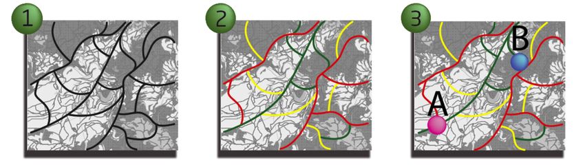
navigation system, Social Gravity, allows groups of people to         investigate the appropriate amount of information
rendezvous by determining a centre of gravity for the group           needed for a satisfying user experience.
of distributed people in the city, and leading them to that
meeting point while preserving the privacy of who was
where [28]. Virtual social networks merge with the real
world to provide users with an enjoyable walking experience
through urban spaces. Several similar approaches and ideas
also emerged in the area of psychogeography. MacFarlane
[13] introduced an exercise, where one put a glass on a city
map, drew a circle, and then followed the route drawn.
Unlike the Space Recommender System, this is not avoiding
busy, popular areas, but simply random.
Positioning of Our Work
Our research differs from prior articles in various aspects.
Firstly, it provides a novel perspective on navigation
applications and location based services, which, instead of
seeking to find POIs (i.e. people) offers users an
opportunity to avoid them. Secondly, we focus on a little           Figure 2. Three designs presented in the online survey: 1)
explored domain; hiking instead of cities [5] and shopping              SMS alert, 2) radar view and 3) map with alert.
malls [21]. Thirdly, although earlier research has reported
that people adopt practices to support occasional                 The online survey link was distributed internationally via
unavailability by purposefully avoiding answering mobile          professional and student mailing lists as well as Facebook.
phone calls or messages [20], we take it a step further by        The survey took approximately 20 minutes to complete and
introducing the concept of avoiding social contact in the         was conducted via Survey Monkey online service. Gathered
physical world setting - we do not consider managing              data was both quantitative (7-point Likert scale evaluations)
availability through digital tools, but through physical          and qualitative, open-ended responses.
presence. The fourth aspect, where our research differs
                                                                  RESULTS
from prior articles, is related to aspects of privacy and
location sharing. In the past, the focus has been on either       Online Survey
general privacy concerns, e.g., with whom the location is         Demographics
shared [7], or lies exposed by location-based social media        Of the online survey participants, the majority (92 %) were
[15]. Contrary to these, our approach does not consider           between 18-39 years of age, 66 % lived in northern Europe,
these aspects but focuses on avoiding face-to-face                18 % lived in central Europe and 62 % were male. In
encounters. Moreover, our approach is not dependent on            general, participants were from all over the world,
people’s location sharing in social media, as, e.g., in [10] or   excluding South America and Africa. 90 % stated that they
other recent apps like [3,6].                                     used map applications regularly, whereas the use of
RESEARCH ON USER GROUP                                            tracking applications was less frequent (40 % mentioned
Already in the early planning phase, we decided to include        using Endomondo, Nike Run, Sports Tracker or Google
participants in every stage of the application design phase       Latitude).
according to the practices of user centric design. User           Hiking experiences
feedback contributes novel development ideas as well as           64 % of the participants had hiked, although 56 % of them
possible further use cases for such an application.               mentioned going hiking only 1-2 times a year. Popular
At the beginning of the project, an online survey with 157        hiking areas were different natural locations (i.e. forests,
participants, as well as two focus group sessions with            countryside, mountains). Urban environments were
altogether 14 participants, were arranged to receive user         preferred destinations for only 16 % of the respondents.
feedback. The online survey investigated:
•   Users’ hiking behaviour by charting the hiking                Reason for hiking               Reply count (x/100) %
    frequency, preferred seasons and locations, preparation
    actions before the hike as well as some in-depth              Enjoying the nature                          47 %
    questions such as reasons for hiking.
                                                                  Physical exercise                            38 %
•   The asocial concept attitudes. Three         pre-designed
                                                                  Relaxation                                   25 %
    application alternatives with varying        amounts of
    information were presented (see Figure       2). The aim      For fun                                      14 %
    was to discover the most preferred            design and
                                                                    Table 1. Quantified categories arguing reasons for hiking.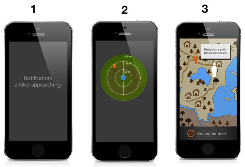
As seen in Table 1, the most frequently emerged themes for            useful and disturbing using a 7-point Likert scale. After
  hiking were enjoying the nature, or related to exercising and         individual assessments, the three were presented together in
  fitness, relaxation and fun. Hiking in the nature is a way to         a row and respondents were asked to vote for their favourite
  escape the hectic urban sprawl and the constant technological         design and give feedback about their choice.
  interaction. When preparing for the hike, in regard to
                                                                        Altogether 73 % of the respondents voted design no. 3
  technology use, nearly half (44 %) replied that they used
                                                                        (map) to be the best design concept. Participants valued the
  Google Maps for studying the route beforehand. Online
                                                                        spatial, geographical information and the alternative route
  forums and blogs were browsed for recommendations and
                                                                        suggestions helping to avoid approaching unwanted
  peer-reviews, whereas more familiar routes required only a
                                                                        company. A plain SMS was perceived fast and easy but
  little preparation. Almost all (96 %) carried a mobile phone
                                                                        also stressful since the signal could disturb the hiking
  with them while hiking. However, the phone was mainly
                                                                        experience. Also, an SMS did not provide enough
  used for backup, but occasionally also for taking pictures and
                                                                        information about the approaching hiker, which was
  navigation if a signal was available.
                                                                        criticized by the respondents. The radar view received the
  Asocial concept feedback                                              second best ratings but it also lacked information about the
  The results of the application evaluation section were                speed and direction of other hikers seen in the radar view.
  somewhat polarized. The opinions towards asocial                      When comparing hikers and non-hikers preferences for the
  navigation were for or against the concept (44 % positive             best design, it appeared that there are no statistically
  and 40 % negative evaluations). The responses indicate that           significant differences between the two groups.
  others did not mind at all encountering unfamiliar people
  whereas others wished to avoid unwanted interaction while             Respondents were asked to choose a suitable modality
  hiking. “I like the idea. I have hiked a couple of times, and         (visual notification, haptic notification or sonification) of
  when I did it, I went because I wanted to see nature and              how they wanted to be informed of other hikers nearby. 64
  beautiful scenery instead of other people. I completely get           % opted for a visual notification (checking smart phone
  this idea, it’s awesome” (participant #14). “I think it's an          screen for approach signals when needed), 47 % opted for a
  interesting concept but I wouldn't use it. … I also think             haptic notification (e.g. vibrating belt) and just 27 %
  serious hikers tend to use other tools and not their phone            preferred a notification via sound (e.g. ring tone of a
  for GPS as phones sometimes tend to lose reception when               phone).
  hiking in remote areas. I personally like to hike with others         Focus Groups
  and meet other hikers. Good way to get tips and learn about           Two focus group sessions were arranged to deepen the
  other great hiking places” (participant #7).                          understanding of the emergent design themes. 14
  Design preferences
                                                                        participants were selected by using purposive sampling to
  After general concept-related questions the study ended with          get versatile and diverse feedback. The interviews consisted
  three asocial application designs representing different content      of two different samples so that the first group of eight
  levels. The first design showed a plain SMS notification of an        participants profiled as non-hikers, but were more active
  approaching hiker, whereas the second design revealed a radar         with tracking and mobile applications in general. The
  view showing other hikers inside the radar. The third design          second group of six participants were somewhat active
  represented a map of the area, location and a notification of an      hikers (hiking at least once a month), but less active with
  approaching hiker (see Figure 2).                                     using mobile applications.

  Each design was presented one-by-one separately and                   The sessions lasted one hour during which the interviewer
  participants were then asked to assess them with variables            introduced the asocial concept and asked questions

Figure 3: The Asocial Hiking App System Overview: The network of paths in the ROI is classified using data from OSM and Flickr.
 This results in a ranking how likely it is to meet people on the different paths. Different routes can be calculated based on distance
    and loneliness (see examples in Figure 5). While on the hike dynamic information can be incorporated as shown in Figure 4.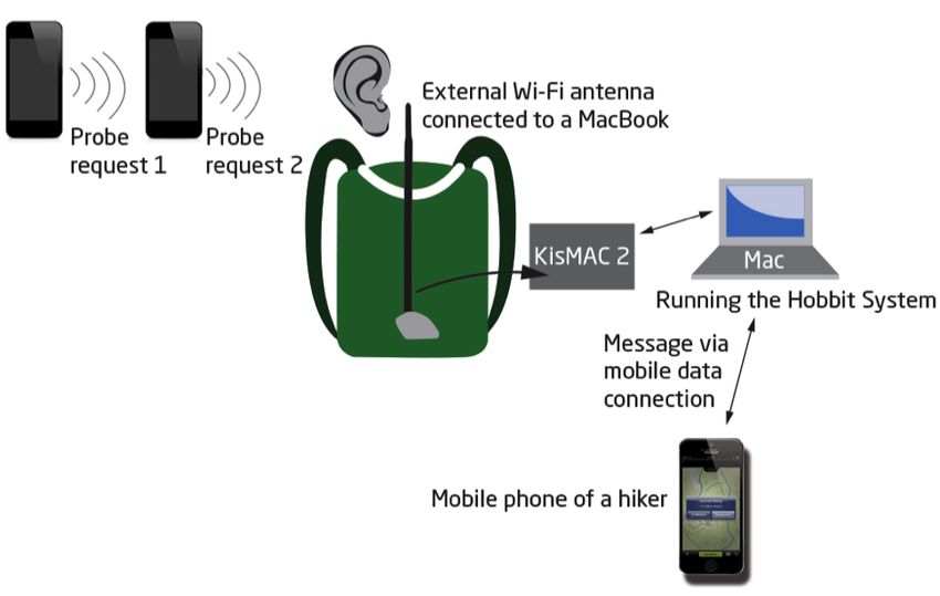
concerning the overall concept idea as well as avoiding              Vibration was perceived a subtler indicator than sound.
approaching company. The three alternative application               Sound is perceived to be stressful and annoying in the
designs were presented and feedback asked about them                 hiking context although being an efficient indicator.
individually. Finally, the participants chose their favourite
modality (vision, haptic, sound) for the application signal.    •    The most preferred way to deal with approaching hikers
Before the sessions, each participant filled out a                   is to adapt hiking speed, leave or change the route before
demographics questionnaire and afterwards a feedback                 encountering. Hiding is perceived awkward.
form where everybody voted for the best design and stated       HOBBIT – THE ASOCIAL HIKING SYSTEM
their perceptions in general about the concept. Each session    Based on the viewpoints of the survey and the focus
was recorded with a video camera and transcribed.               groups’ interviews we developed HOBBIT, the asocial
                                                                hiking system. The HOBBIT system consists of two main
Demographics
The average age was 29.4 years and 38 % were female. 54 %       parts: the first part is a desktop application that allows users
were students, 46 % were working in different jobs varying      to generate solitary hiking routes within a region of their
from office desk jobs to farming. 92 % owned a smartphone       interest (ROI). The routes are based on OSM data. This is
whereas 77 % were familiar with tracking applications such      depicted in Figures 5 and 6. These routes can be transferred
as Google Latitude, Endomondo and Sports Tracker, but only      to a mobile device and user can walk along these routes
38 % stated using them on a regular basis.                      with the help of most standard hiking apps of their choice.
                                                                In addition, users can be informed about approaching hikers
Design Drivers for Prototype Implementation                     with the help of a Wi-Fi sniffing component as can be seen
The results from the design and modality section aligned        in Figure 4. A Wi-Fi card turned into passive mode is
with the results derived from the online survey. 92 %           constantly looking for nearby Wi-Fi devices in the
preferred the map design for its informative nature.            environment of the hiker to generate warnings (as described
Information about surroundings, locations, route                in detail in the implementation section).
alternatives, direction and speed of an approaching hiker
were favored in both groups. An asocial signal was not
enough but rather extra information on top of a map
application was preferred. “This is more useful because it
has a map. I would like to know additional routes if I am
about to encounter somebody” (participant #3, focus group
1). In the first group, the preferred notification modality
was haptic. It was considered to give a subtler signal than
sound, which was associated with stress and work-related
messages. “I associate ringtone to work, and I do not want
that while hiking” (participant #2, focus group 1). The
second group favored a visual signal, thus having the
freedom to decide when to check information about nearby
hikers. “It is not always crucial information if somebody is
approaching. I would like to decide for myself whether I need       Figure 4. Illustration of the components used during the
the information or not” (participant #4, focus group 2).            user test. The backpack of the experimenter contained an
                                                                      external Wi-Fi antenna connected to a MacBook. The
When participants were asked about possible reactions for               KisMAC 2.0 software running on the MacBook is
the approach signal, the majority of them hoped for an              constantly looking for probe requests. If a probe request
alternative route option to be presented on the application          from an unknown Wi-Fi device is detected the hiker is
map. Hiding was considered awkward. However, leaving                     receives a notification on his/her mobile device.
the route for the hikers to pass by was considered a worthy
option for avoiding interaction.
                                                                As can be seen in Figure 3, the users have to perform three
The online study as well as the focus group interviews          main steps to generate a solitary route. First, the users need
provided critical viewpoints to be considered with the          to select a ROI in which they wish to hike. In this ROI the
prototype implementation process.                               HOBBIT system then classifies all hiking paths regarding
•   Users perceived the asocial hiking application as extra     the chance to meet other hikers, as explained later in detail.
    information on top of an LBS application.                   Then users can select a start and endpoint of a hike in the
                                                                application and the system calculates a solitary route. The
•   A combination of approach signal and map provides           prototype was also able to react to other hikers presence by
    sufficient amount of information.                           dynamically updating the route and contained a simulation
                                                                mode.
•   A plain visual message gives the user the freedom to
    decide whether and when to check possible encounters.
In the following, we describe in detail how we classify To calculate the update weight (wu) for a single path we
routes into segments, where one would likely meet other simply used the average of both weights.
hikers, and segments where one will likely be on his/her
POIs Information based on OSM and Flickr data
own. We also use the terms path or edge (as multiple POIs are the locations we want to avoid because, as the
paths/edges form a graph) for a route segment. Then we name implies, many people are generally attracted by these
describe the different options to calculate a path on this places. The POIs taken into account from OSM are pubs,
route network and also describe the functionality of our Wi-
restaurants, shops, tourist attractions and historical sites.
Fi sniffing component that detects other hikers based on
Each POI category is considered of equal importance to
probe requests from their Wi-Fi cards. In the following
avoid, since the idea of the application is to help to enjoy
description, track and route carry the same meaning. the solitude, not to guide to popular attractions. We use the
Classification of Routes same heuristics for the Flickr data. From Flickr we can
As can be seen in Figure 3, to generate solitary routes we receive a list of geotagged pictures in the ROI. Each picture
used information about the editing history of OSM as well indicates that someone has been there before and the place
as point of interest (POI) information from Flickr to add was worth taking a picture. Based on this we assume that
weights (indicating the “loneliness” of a route segment) to the specific locations are rated more crowded than places
the edges of the graph. We classified each edge with an where no pictures were taken. Several pictures taken in a
overall classification into nine classes ranging from not given radius will result in a higher weight.
very likely (low weight) to run into other people to very
For both data sets we used a simple k-mean clustering
likely (high weight) for the selected ROI using a set of
approach (“k” is dependent on the size of the ROI and the
different variables consisting of Timestamp and version
number of geotagged pictures within that area), that groups
number of a path in OSM, POI data from OSM and
nearby POIs based on their vicinity. After that the clusters
geotagged photos from Flickr.
were classified based on the number of data points they
Visually this will be represented with weight-coded colours contain. Unlike the timestamp and version data, which exist for
ranging from green to yellow to red, where green indicates every single path, POI and Flickr data are only relevant to
a low weight and red indicates a high weight. Different paths in their vicinity. Their clusters represent regions that
routing options can be used (see Figure 5) trying to find a exert an influence (their weight) on all nearby paths (about
good trade-off between the shortest path between two 100-125m and 75-100m for typically sized hiking areas; again
points and less crowded routes. this depends on the selected ROI). This means that in the
absence of nearby POI or Flickr data points, a road will always
Editing History of OSM based on timestamp and version
number have a weight of “0”. An edge that is influenced by (i.e.
The timestamp and version number of a path from the OSM intersects with) one or more clusters will receive the weight of
dataset represent how long ago and how often a path has the highest weighted cluster. We call this weight (wpoi).
been updated respectively. We have chosen to classify these Combining Editing History and POI
values separately and then combine them into a single From both weights (wu) and (wpoi) a single weighted graph
weight, which we call the update weight. The update weight is created. For each path it is checked if (wpoi) is larger than
is the average weight using timestamp data and version (wu). If (wpoi) > (wu) is true, (wpoi) is assigned as a weight
number and calculated as follows: for that path. Otherwise, we calculate the weight that is
Timestamp data gives us the information when the edge assigned to the path by using (wpoi+wu)/2. This reduced the
was last updated in OSM. We used simple standard weight of the update weight by lowering the weight in areas
deviation classification technique for timestamps. This with few POI data. We found that the combined approach
classification method finds the mean value, then places succeeds in preserving POI and Flickr information, while
class breaks above and below the mean at intervals of either slightly lowering the importance of the update weights for
.5, standard deviation until all the data values are contained areas that are lacking POI data. We evaluated our approach,
within the nine classes. We count edges, updated a long by letting different ROI experts judge the feasibility of our
time ago, as lonelier than edges recently updated, as these classification approach. Basically they confirmed that this
rating schema produces a good classification how often a
get more attention than edges updated in the past.
path is used by hikers. In general, this was also confirmed
The version numbers give us information about how often a by our results in the user study and comments by the users
path was updated. Again, we count paths, updated just once after the study (see below).
or twice, as lonelier paths are updated less frequently. To
Route Planning
classify the version numbers we first transformed the data
In order to perform routing on a weighted graph the
on a logarithmic scale. We do this to give low version
algorithm A* is used. A* typically uses distance as a basis
numbers a noticeable weight if there are relatively much
to calculate the "shortest path" in a graph. In our case, we
larger version numbers present in the data set. Then we
also took the “loneliness weights” of the paths into account.
classified them into 9 same sized classes.
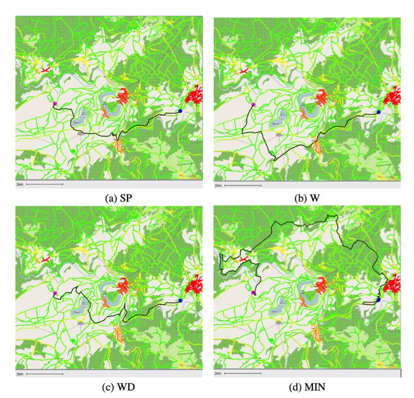
The routing (modes) options are:1. Shortest Path (SP): Used as a reference. running on a MacBookAir. Using KisMAC 2.0 we put an
external Alfa AWUS036NHR wireless card with an
2. Weighted (W): Path of lowest cumulative weight
additional antenna (see Figure 4) into passive mode and we
under a certain threshold t.
performed a scan every 5 seconds. Passive mode is also more
3. Weighted Distance (WD): A combination of (1) commonly known as monitor mode. In passive mode a Wi-Fi
and (2) card monitors all Wi-Fi traffic nearby without transmitting or
interfering with it. With this setup we can identify if
4. Minimal (MIN): Path that minimizes the highest unknown Wi-Fi devices are near the hiker. By doing war
encountered weight (such routing might take an
driving before the test-run we filtered out stationary Wi-Fi
enormous detour)
devices that already existed in our hiking environment. Once
Figure 5 shows how the four different options effect the a probe request from an unknown device was found, we sent
route planning in a given ROI. an iMessage to the hiker’s device informing about a nearby
hiker (as also shown in Figure 4).
EVALUATION
We ran a user study to test the feasibility of the HOBBIT
system. The goal of the user study was to get insights about
the use of such an application by hikers in-the-wild. As
there is no-standard protocol for evaluating asocial
technologies in-the-wild yet, we needed to make a few
compromises, when conducting the study. In general we
carefully balanced the advantages and disadvantages of all
the decisions involved in the setup of the evaluation to get
the best grasp on how people would use such a novel
technology and react to it. For example we decided to have
a researcher companying the test subjects, as we rated the
risk of the users getting completely lost in the woods higher
than having a silent companion interrupting the moments of
solitudes. Similarly we decided that the researcher would
record all the users’ interaction rather having the users
wearing a bulky video recording system.
Participants & Apparatus
The study took place in a local hiking area near the city of
Figure 5. Results using different routing. All edges in the
Aachen in Germany with 8 participants, 5 males and 3
graph are classified by their “degree of loneliness”. The ROI
is a famous hiking area near Spa, Belgium (waterfalls of
females with an average age of 29.1 years. 4 participants were
Coo). (a) shortest path, (b) lowest cumulative weight, (c) graduates from two different universities nearby the hiking
weighted distance, (d) path that minimizes the highest area and 4 participants worked in different jobs. All
encountered weight. participants were active hikers (hiking more than once a
month) and all owned a smartphone. The study was
Implementation conducted during 3 days (2 Sundays and one Saturday) within
The first part of the HOBBIT system, which is the route- 2 weeks in late August 2013. Weekends are typically busy
planning tool, was developed as a desktop application using hiking days in this hiking area. We wanted to have the track
J2SE. OSM and Flickr information are crawled from the most likely populated by other hikers to investigate, how
Internet when a certain ROI is selected and stored in a local people react when the HOBBIT system detects them and
XML format. Tracks can be saved in the GPX format to hand shows warnings. In addition, we also wanted to find out how
them over e.g. to a mobile application (the user study well the HOBBIT system creates solitary routes, when
section). We also developed a mobile extension of HOBBIT comparing them to more standard tracks in the area. Therefore
to inform hikers about nearby hikers using Wi-Fi signal the researcher also walked an official trail of 6.5 km before
detection. We utilized the fact that a device having a Wi-Fi the user tests on the 3 days and counted all hikers passing by.
card constantly transmits probe requests. A probe request is a Overall, the hiking conditions were good (as also confirmed
special frame sent by a client requesting information from by the participants) with partly cloudy sky to sunshine and
either a specific access point, specified by SSID, or all access temperatures between 18 and 27 degrees Celsius with no rain.
points in the area, specified with the broadcast SSID. In other The calculated track by the HOBBIT system within hiking
words, the client wants to check if networks are around (by area Aachener Wald was approximately 6.5 km long. The
looking at the SSID) to which it was connected before, to route was transferred to the commercially available hiking
connect again. To detect these probe requests KisMAC 2.0, a application. The application was running on an iPhone 4s. 2
wireless network discovery tool for Mac OS X, was used,users were already familiar with this application; the others hiker. Leaving the route was not allowed to ensure that all
were briefly introduced to hiking app. The application hikers walked along the same route and that the participant
provides a simple map view and lets the users walk along and researcher did not get lost in the woods. This strategy
the track highlighted on the map (see Figure 1). During the was very successfully used by all participants. Another
hike, participants were accompanied by the researcher, who strategy observed was that participants took a short break
was equipped with a backpack with the Wi-Fi-Sniffing and turned away from the track to have a packed lunch or
software and hardware as described in the implementation take a photo while waiting for the other hikers to pass
section. Of course, this was not optimal for experiencing behind them. Again, none of the hikers wanted to hide in
pure solitude, but was the best trade-off between having the the woods, as was also reported in the focus groups. Two
participants also carry the mobile parts of HOBBIT and other strategies were used by two separate participants. The
equipping them with additional cameras to record their first participant started to hum a song, not being able to
reactions, or feeling uncomfortable during the hike. The greet the hiker passing by. The other did up his shoelaces at
researcher was not allowed to engage in conversation with the moment the other hiker passed by.
the participants and only reacted to questions regarding the
The HOBBIT system was not able to detect mountain
use of the HOBBIT application. The participants were
bikers and horse riders in time for the participants to react
instructed to hike and act as if they were alone. Prior to
to since their speed was too fast. The application was also
each test day, besides hiking the official track, the track
unable to detect hikers who had their Wi-Fi turned off or
calculated by the HOBBIT System was hiked by the
did not have a mobile phone with them at all. Another
researcher to detect static Wi-Fi devices and filter them out
limitation is the inability to show the direction of movement
(this is described as war driving in the implementation
of the approaching hiker. During the interviews, after the
section). The warnings, as we developed them from our
hike, participants expressed overall very positive feedback
interviews, were sent as a visual message on the screen with
and were interested in the application for future use. We
a subtle vibration of the iPhone without sound.
received comments like “Where can I download it to use it
Before the test, the participants filled out a background again tomorrow?” (participants #2, 4, 5, 6). The main
questionnaire. The participants were instructed not to leave advantage for the solitary hiking experience reported by 6
the route. They could react to (or not) any warnings, as they out of 8 participants was the ability to be aware of the
wished. After the test, feedback was collected from a semi- approaching hikers and not being suddenly surprised by
structured interview, and the participants could try out the them. A feeling of being in control was highly valued as
HOBBIT system and plan their own solitary routes. well as the ease of use. The participants also valued that to
use the application, they do not have to sign up for any
Results
service beforehand and share any information with a
All hikers were able to successfully complete the hike
without any mistakes (e.g. leaving the route). The overall service. The technical fact that HOBBIT uses Wi-Fi probes
completion time was about 84 minutes on average, and the to detect nearby hikers was appreciated by all participants
encounter rate was 5.4 people per hike. Despite receiving and was considered as the most important technical design
approximately 3.9 warnings from the HOBBIT system on decision of the HOBBIT system. Participants also
average, the participants still met 1-3 people (with people suggested using the application for contrary purposes, i.e.
we also refer to small groups of people and count them as for security reasons. It would be comforting to know if help
“1 person”, the maximum amount of people in a group was would be near in an emergency situation.
4) on their hikes. The warnings were sent out about 1 DISCUSSION & CONCLUSION
minute before they encountered other hikers (the range of In this paper we have presented HOBBIT, the concept,
the Wi-Fi antenna was about 90 meters). While hiking the development and evaluation of an asocial hiking
official trail (6.5km) the researcher met 8.3 people on application, which enables solitary hiking by informing the
average. This gives a good indication that the HOBBIT user of approaching people. In addition to the prototype
system calculates solitary routes for a certain ROI. All implementation, we have investigated user expectations and
participants reacted to all warnings; except two participants needs by conducting vast and thorough inquiries regarding
who ignored two warnings (94 % reaction rate). When application design guidelines and modalities. We
asked the reason for ignoring, both people said, that the researched how people can avoid interaction with one
warning and the vibration alone was already a mental another through technology. We show that hiking alone can
preparation for them to meet other people. be supported or mediated by the use of technologies.
The participants reacted differently to the warnings. In most Design Drivers from the User Research
cases the participants first tried to locate the approaching The results from the online survey as well as two focus
hiker. Most common was then to slightly adjust the walking groups show that users prefer having a map UI attached to
speed (slowing down or speeding up) to avoid meeting the asocial notifications. A map provides other useful
hiker. The participants also reported afterwards that they information for hikers, such as information about the
would also have left the route at some points to avoid a location and surroundings as well as visual guidelines (i.e.alternative routes) for avoiding the company of approaching also want to stress, that our application is not for avoiding
hikers. Regarding social aspects, a map provides the user everybody. Primarily, it provides the user a possibility to
with an excuse to check the locations of other hikers while lessen the encounters with other hikers.
viewing useful information about the surroundings.
Methodological and Cultural Considerations
Approach signals were preferred to be tactile, enabling users We acknowledge that our work is limited by the spatial,
to have subtle feedback. Mostly users wanted to decide for social and cultural settings of our research. For the
themselves whether they wanted to be aware of other hikers. practicalities related to the concept evaluation, we were
In the prototype, the signal was a subtle vibration with a restricted to the use of hiking tracks taking only a few
visual message on the smart phone screen. Sound was hours, instead of longer trails, which would probably have
perceived as stressful, occupying the user’s attention. attracted hikers seeking solitude. Also, the researcher
However, during the in-the-wild interview, the participants shadowing the hiker may have caused some interference
suggested using bird sounds as approach signals. with the study, although the interaction was kept to a
minimum. We acknowledge that the sample does not
Perceptions of the Asocial Application Concept
consist of hikers only; with the versatile participant sample
The gathered feedback provided overall two-fold opinions
we received feedback concerning technical and visual
towards the asocial hiking concept. Half of the participants
aspects as well as how the app would be best utilized during
found the concept interesting and probably useful. These
hiking. However, we still have a good representation of
users appreciated solitude in their hiking and enjoyed the
hikers: a) In the call, the online survey was advertised
tranquillity of nature whereas the other half could not
especially for hikers, but included hikers with different
comprehend the need for such an application. During the in-
activity levels as well as non-hikers. b) Focus group (FG) 1
the-wild study, every participant of the user study enjoyed
included tech-oriented people to give insights into
and valued the use of the HOBBIT system.
application development, whereas FG 2 consisted of active
As pointed out in a prior article [9], context-aware systems hikers. c) Participants of the field test were all active hikers.
should be designed so that they do not cause unnecessary
Although the study was conducted in an international
interruptions. This could also be seen in the prior
environment, there are cultural differences that need to be
interviews, where subsequent alarms were found irritating,
addressed when designing the asocial application further.
and which should be corrected in the next iteration by
As noted from the online questionnaire, the opinions
introducing a longer time window to block sequential
towards the concept were strongly twofold. In addition, the
notifications. During the user test, combining a visual
application should be designed to provide sufficient
message with a subtle vibration enabled us to ensure that
information, but not overwhelming the hiker with an
the participant became aware of the approaching company
excessive amount of signals and content that would disrupt
and reacted to the upcoming encounter, rather than
the actual activity – the hiking. We acknowledge that
potentially accidentally missing a plain visual indication.
leaving technology behind can be one key aspect of hiking.
Technical Approach However, our concept does not seek to be a general solution
In our case the use of technology could be considered as everybody should use, but it offers a tool for such hikers,
passive. The application does not rely on social media data who would appreciate a mobile tool that could help in
since users do not have to sign up for the service online. avoiding encounters with other hikers.
This is the main contrast to similar solutions such as the
Future Work
Hell Is Other People app [8], that simply monitors friends’
Our plans for future research include a diary study for long-
check-ins on Foursquare to figure out where they might be
term hikes, where people stay in the wilderness for several
and then creates Voronoi diagrams on a map around these
days. By looking at these really solitary hikes, we seek to
place and warns the user, when entering them.
understand the desires and strategies related to asocial
A potential challenge to our application is a condition, navigation, and look closer at what role technology plays in
where all other hikers turn their WLAN off (which did not preparing and conducting hikes. We also aim to make the
occur during our in-the-wild study). Assuming this, we can HOBBIT system more mobile. Therefore the Wi-Fi module
argue with a twofold solution: 1) the desktop tool will still of the mobile device needs to be turned to passive mode.
be able to provide you with lonely tours - independent of This is currently not possible without rooting the device and
whether people use their mobiles on the hikes or not. 2) We also no external antenna could be attached.
could also source more digital noise, such as Bluetooth or ACKNOWLEDGMENTS
GSM signals. It is our belief that the digital noise, tracking We would like to thank Antonio Krüger and Alan Dix for
technologies, and technology use in general will be more extensive initial discussion on this topic during a Dagstuhl
and more prominent in the future in various sectors of life, Seminar in early 2013, and Johan Janssens for the initial
including the hiking context. We emphasize that our development to solitaire routes. The work was also partially
technical solution is already functional for short hikes, and supported by a Google research faculty research award and
opens possibilities for further technical development. We Tekes Finland Illuminate project.REFERENCES 16. Pielot, M., Heuten, W., Zerhusen, S. and Boll, S. Dude,
1. Abowd, G., Atkeson, C., Hong, J., Long, S., Kooper, R., where's my car? evaluation of a tactile car finder. In
Pinkerton, M., Cyberguide: A mobile context-aware Proc. NordiCHI’212, ACM Press (2012), 166-169.
tour guide. Wireless Networks 3, 5 (1997), 421-433.
17. Preece, J., Rogers, Y., and Sharp, H. Interaction Design.
2. Abowd, G.D, Dey, A.K., Brown, P.J., Davies, N., Beyond Human-Computer Interaction. John Wiley &
Smith, M. and Steggles, P. Towards a Better Sons, Ltd., 2002.
Understanding of Context and Context-Awareness. In
Proc. HUC’99, Springer Verlag (1999), 304-307. 18. Raper, J., Gartner, G., Karimi, H., and Rizos, C. A
critical evaluation of location based services and their
3. BroApp.https://play.google.com/store/apps/details?id=n potential. In Journal of Location Based Services 1,1
et.broapp.app (2007), 5-45.
4. Böhmer, M., Hecht B., Schöning J., Krüger, A., Bauer, 19. Rukzio, E., Müller, M. and Hardy, R. Design,
G. Falling asleep with Angry Birds, Facebook and implementation and evaluation of a novel public display
Kindle: a large scale study on mobile application usage. for pedestrian navigation: the rotating compass. In Proc.
In Proc. MobileHCI’11, ACM Press (2011), 47-56. CHI’09, ACM Press (2009), 113-122.
5. Cheverst, K., Davies, N., Mitchell, K., Friday, A., 20. Salovaara, A., Lindqvist, A., Hasu, T. and Häkkilä, J.
Efstratiou, C. Developing a context-aware electronic The Phone Rings but the User Doesn't Answer:
tourist guide: some issues and experiences. In Proc. Unavailability in Mobile Communication. In Proc.
CHI ’00, ACM Press (2000), 17-24. MobileHCI 2011, ACM Press (2011), 503-512.
6. Cloak. https://itunes.apple.com/us/app/cloak-incognito- 21. Sarjanoja, A.-H., Puikkonen, A., Haveri, M., Huhtala,
mode-for-real/id830708468?mt=8 J., Häkkilä, J. Towards Designing Better Maps for
7. Consolvo, S., Smith I.E., Matthews, T., LaMarca, A., Indoor Navigation – Experiences from a Case Study. In
Tabert, J., Powledge, P. Location Disclosure to Social Proc. MUM’09, ACM Press (2009).
Relations: Why, When, & What People Want to Share. 22. Schiller, J., Voisard, A., eds. Location-based services.
In Proc. CHI’05, ACM Press (2005), 81-90. Morgan Kaufmann, (2004).
8. Dunlop, M., Brewster, S. The challenge of mobile 23. Schmidt, A., Beigl, M. and Gellersen, H. There is more
devices for human computer interaction. In Personal context than location. In Computers and Graphics
and ubiquitous computing 6, 4 (2002), 235-236. Journal 23, 6 (1999), 893-902.
9. Häkkilä, J., Mäntyjärvi, J. Developing Design 24. Schöning, J., Hecht, B., Rohs, M., & Starosielski, N.
Guidelines for Context-Aware Mobile Applications. In (2007). WikEar–Automatically generated location-
Proceedings of Mobility’06, ACM Press (2006), 1-7. based audio stories between public city maps. In Proc.
of Ubicomp’07, 128-131.
10. Hell is other people. http://hell.j38.net/
11. Hile, H., Vedantham, R., Cuellar, G., Liu, A., Gelfand, 25. Schöning, J., Krüger, A., Cheverst, K., Rohs, M.,
N., Grzeszczuk, R. and Borriello. G., Landmark-based Löchtefeld, M., and Taher, F. PhotoMap: using
pedestrian navigation from collections of geotagged spontaneously taken images of public maps for
photos. In Proc. MUM’08, ACM Press (2008), 145-152. pedestrian navigation tasks on mobile devices. In Proc.
MobileHCI’09, ACM Press (2009), 14-24.
12. Kray, C., Elting, C, Laakso, K., and Coors, V.
Presenting route instructions on mobile devices. In 26. Traunmüller, M., Schieck, A., Schöning, J., and
Proc. IUI’03, ACM Press (2003), 117-124. Brumby, D.P. The Path is the Reward: Considering
Social Networks to Contribute to the Pleasure of Urban
13. MacFarlane, R. A Road of One's Own: Past and Present Strolling. In Proc. CHI EA’13, ACM (2013), 919-924.
Artists of the Randomly Motivated Walk, In Times
Literary Supplement, 7th Oct. (2005) 3-4. 27. Tsukada, K., Yasumura, M. ActiveBelt: Belt-Type
Wearable Tactile Display for Directional Navigation. In
14. May, A. J., Ross, T., Bayer, S. H. and Tarkiainen, M. J., Proc. of Ubicomp 2004, Springer (2004), 384-399.
Pedestrian Navigation Aids: Information Requirements
and Design Implications. In Personal and Ubiquitous 28. Williamson, J., Robinson, S., Stewart, C., Murray-
Computing 7 (2003) 331-338. Smith, R., Jones, M. and Brewster, S. Social gravity: a
virtual elastic tether for casual, privacy-preserving
15. Page, X., Knijnenburg, B. P., Kobsa, A. What a Tangled pedestrian rendezvous. In Proc. CHI’10, ACM Press
Web We Weave: Lying Backfires in Location-Sharing (2010), 1485-1494.
Social Media. In Proc. CSCW’13. ACM Press (2013),
273-284.You can also read