Volcanic hazard communication using maps: an evaluation of their effectiveness
←
→
Page content transcription
If your browser does not render page correctly, please read the page content below
Bull Volcanol
DOI 10.1007/s00445-007-0124-7

 RESEARCH ARTICLE

Volcanic hazard communication using maps: an evaluation
of their effectiveness
Katharine Haynes & Jenni Barclay & Nick Pidgeon

Received: 3 May 2006 / Accepted: 3 January 2007
# Springer-Verlag 2007

Abstract Hazard maps are considered essential tools in the      However, the most striking increase in effectiveness was
communication of volcanic risk between scientists, the local    found with the perspective photographs, which enabled
authorities and the public. This study investigates the         people to identify features and their orientation much more
efficacy of such maps for the volcanic island of Montserrat     readily. For Montserrat it appears that well labelled aerial
in the West Indies using both quantitative and qualitative      and perspective photographs are the most effective geo-
research techniques. Normal plan view maps, which have          spatial method of communicating volcanic risks.
been used on the island over the last 10 years of the crisis,
are evaluated against specially produced three-dimensional      Keywords Volcanic hazard map . Volcanic risk map .
(3D) maps and perspective photographs. Thirty-two demo-         Montserrat . Volcanic risk communication . Evaluation .
graphically representative respondents of mixed back-           Geo-spatial
grounds, sex, education and location were interviewed and
asked to complete a range of tasks and identification on the
maps and photographs. The overall results show that             Introduction
ordinary people have problems interpreting their environ-
ment as a mapped representation. We found respondents’
                                                                  “Although maps are everyday tools for volcanologists,
ability to locate and orientate themselves as well as convey
                                                                  they are often too abstract and difficult for many users
information relating to volcanic hazards was improved when
                                                                  of volcano warnings”. (Newhall 2000, p1190)
using aerial photographs rather than traditional plan view
contour maps. There was a slight improvement in the use of         A map is an illustration of the space and environment
the 3D maps, especially in terms of topographic recognition.    around us, coded and simplified to allow communication
                                                                (Muehrcke 1978; Monmonier 1996, 1997). Hazard maps
                                                                have become a fundamental means of communicating
Editorial responsibility: S. Nakada
                                                                volcanic risk to the public. They are used to explain and
K. Haynes : J. Barclay : N. Pidgeon                             display the distribution of hazards, risk levels of areas likely
School of Environmental Sciences, University of East Anglia,
                                                                to be affected and areas where access may be denied in
Norwich, UK
                                                                times of crisis. Maps also form an integral part of emergency
Present address:                                                plans and response where they are considered vital for the
K. Haynes (*)                                                   coordination of preventative, protective and rescue evacua-
Risk Frontiers, Natural Hazards Research Centre,
                                                                tions (Dymon and Winter 1993; Nourbakhsh et al. 2006).
Macquarie University,
NSW 2109 Sydney, Australia                                      This study examines the effectiveness of such maps for
e-mail: khaynes@els.mq.edu.au                                   communicating volcanic risk on the island of Montserrat in
                                                                the West Indies.
Present address:
                                                                   Volcanologists and other scientific professionals are
N. Pidgeon
School of Psychology, Cardiff University,                       trained to interpret geospatial information in many different
Wales, UK                                                       contexts. There is little empirical research to support the
Bull Volcanol
assumption that a lay audience will be able to read and flows. The differing types of activity are usually either
interpret a topographic hazard map with the same skill represented as separate hazards or as zones where the
(Handmer 1985) or that presenting the information in this assigned hazard status is an accumulation of the hazard
way modifies public behaviour or attitudes towards that from each of the potential types of activity. Hazard maps
hazard. If, for example, non-scientific users were reluctant are very often combined with socio-vulnerability informa-
to confess to map reading difficulties and have a different tion to produce risk maps.
spatial ‘reality’ to the scientists, it is likely that misunder-
standings and confusion will prevail (Newhall 2000). This
would have serious consequences for risk communication. The use of hazard maps on Montserrat
No systematic studies exist which evaluate how non-
specialists decode and comprehend the information con- Simplified topographic maps have been used by the
tained within volcanic hazard maps. However, limited Montserrat Volcano Observatory (MVO) as the base for
research in the case of flood map comprehension has shown hazard maps throughout its recent and ongoing eruption
that standard contour-based maps are not an effective (Young et al. 1997). These maps have been used to com-
method for communicating hazard and risk information municate hazard zones to local government officials and
(Handmer and Milne 1981). To make matters worse, vol- the general public. Together, the MVO and local authorities
canic maps often become a ‘work in progress’ due to changing have used these hazard maps as the basis for risk maps.
volcanic activity and knowledge, causing the hazard and Between May 1996 and July 1997 the island was ‘micro-
risk zones to be in a constant state of adjustment, thereby zoned’ into a number of hazard zones whose risk status
adding to the confusion. varied in accordance with the status of the current Alert
The purpose of this study was to pilot a methodology for Level (see Kokelaar (2002) and Aspinall et al. (2002)). The
the systematic evaluation of the effectiveness of maps as purpose of these geographic divisions was to allow
methods of risk communication and to provide evidence for continued utilisation of as much of the island as possible,
ways in which maps could be improved if necessary. Both whilst reducing the need for evacuations. The large number
qualitative and quantitative methodologies were used to test of small zones reflects this pressure for precision (Kokelaar
map comprehension on a representative sample of local 2002). The states of the zones were associated with five
residents on the volcanically active island of Montserrat in alert levels that reflected changing volcanic activity and
the Caribbean. Different map formats were used to appraise determined access to the zones. Eleven different maps were
their impact on understanding. As the first study of its kind produced over a 13-month period, thus complicating the
dealing with volcanology, we also present a brief review of communication to a lay audience of an already difficult
the use of volcanic hazard maps and a summary of literature emergency management tool (Pattullo 2000; Kokelaar
relevant to testing map comprehension. Much of the relevant 2002). Whether understood or not, the changing restrictions
literature comes from the use of maps for communicating on access were often treated loosely by the authorities and
risk information about other natural hazards, in particular islanders (Kokelaar 2002). In response to the event of the
flooding. 25th of June 1997 (when 19 people were killed in a series
of Pyroclastic flows—see Loughlin et al. (2002)) and the
escalating volcanic activity, the maps were greatly simpli-
Volcanic hazard maps fied (Kokelaar 2002) and reduced to an Exclusion Zone,
Daytime Entry Zone and Safe Zone. With the exception of
Volcanic hazard maps usually display the current or some limited movement of the zone boundaries, these
potential extent of dangerous volcanic flows (lava, pyro- remain unchanged until the time of writing (February,
clastic or lahar) together with the potential distribution of 2006). Simplified topographic maps still form the basis for
tephra. Topography is a major factor controlling the the visual communication of the location of the zones by
distribution of many volcanic hazards, therefore the presen- the MVO and the authorities.
tation of relief, traditionally displayed with contour lines
is a very important component. Maps also often show main
areas of housing and road networks. Previous work on natural hazard map comprehension
Hazard maps relating to volcanic activity can be
extremely complex. Volcanic eruptions, as distinct from Despite the increasing use of maps to convey spatial risk
many other natural hazards (e.g. earthquakes, tsunami and information, evaluations of their effectiveness, in particular,
floods) may subject any one particular location to a range their comprehension by the public has largely been
of different hazards. A town, for example, could be at high neglected (Handmer and Milne 1981; Dymon and Winter
risk from ash fall but low to moderate risk of pyroclastic 1993; Moen and Ale 1998). The limited literature thatBull Volcanol exists is largely based on the behavioural response after the Improving the efficacy of maps release of flood hazard maps and not the comprehension of the map itself. This does not adequately address: (1) Limited literature has shown the value and superiority of whether people can decode the map to understand the aerial photos in aiding spatial comprehension. For example, information as intended by the communicator; and (2) Delucia (1978) asked respondents to locate, identify, count whether the information, once decoded and understood, and estimate features and then answer verification (true/ will alter the receivers’ risk perceptions, awareness and false) statements about features and routes. Aerial photo- behaviour to conform to that of the communicators. graphs were found to be most effective for all tasks except Roder (1961) evaluated the use of maps on the residents the count and estimate questions where the map was of the Topeka flood plain, in Kansas (USA). The study superior. It was inferred that the obliquity of aerial photos identified that most people had not received or seen the presented the interpreter with a view that is much more like map before, those that had found problems interpreting a scaled down version of reality. contours and even those who knew the area well found it A study in the New Guinea Highlands found that those difficult to orientate and locate themselves on the map. who had received some education could interpret aerial Respondents stated that they would rather rely on their own photographs despite being unable to read maps (Handmer observations and experience of floods than the map. 1985). This was explained by a combination of improved A literature review by Handmer and Milne (1981) cognitive skills and the rugged topography that enabled the described a slim and embryonic research area that included inhabitants to experience actual aerial views of the land- five studies (including that of Roder (1961)). They con- scape. This increase in effectiveness is similar to that attrib- cluded that flood maps had a low utility as a source of uted to an information filtering difference by Monmonier public information. Problems encountered were partly to do (1996); in drawn maps the cartographer does the filtering with the level of public interest in the maps as well as their for the user, but with photographs the user filters their own comprehension. However, even if understood, it was clear information. Thus, the spatial items are in their correct rela- from the five studies that the relationship between the tive scale, critical to a lay person’s understanding. Handmer comprehension and behavioural change in relation to the (1985) points out the importance of recognising the risk was very weak. This relationship was also confirmed function of the geospatial information; if the purpose is by McKay (1984) who concluded that the perception of for the public to plan evacuation routes then oblique aerial flood risk was improved by maps but that this had no photographs may be best suited. impact on the willingness of participants to seek out similar A good example of tailoring spatial information to suit risk information in the future. This study did not evaluate different audiences is demonstrated by Lantzy et al. (1998) people’s ability to use and interpret the map and therefore in which different groundwater contamination maps are used the positive impact on perceived flood risk cannot be by: (a) scientists for recognising the extent of the problem; separated from other background information the partic- (b) environmental and site managers for evaluating remedial ipants may have received. options; and (c) a 3-D computer animated model used for the Handmer (1985) summarises two studies in Australia public in an open forum. Although these researchers where respondents were asked to determine whether their recognised the need to tailor the information to the needs of properties lay inside or outside a particular flood zone. He their target audiences, they did not evaluate the effectiveness concludes that the general map skills of the interviewees of the information transfer and simply assumed that because were adequate enough to either locate or approximately they had made it simple, then it must be giving the intended locate their houses successfully. However, they had prob- message to the public. Other studies cited above might lems interpreting the flood risk information and compre- justify some scepticism as to whether this was really the case. hending flooding probabilities. The release of hazard maps in advance of experience or visible evidence of the hazard is often met with scepticism Participatory map design and fear by the local authorities, government and also the public (Handmer 1985). This is due to the threat of Handmer (1985) lists four limitations of standard maps as potential negative effects on house values, insurance rates communication tools: (1) information may not reach the and the local economy (Yeo 2004). Although there exists target audience; (2) it may not be understood; (3) it may not some evidence of negative economic effects, there is also change attitudes; and (4) it may not change behaviour. evidence to suggest these maps actually have no effect (Yeo Therefore, even if maps are understood they are unlikely, 2004). Earthquake and flood risk maps were also not found like most risk reducing education campaigns, to alter per- to have an effect on house purchasing decisions or the take- ceptions and/or behaviour. However, some recent advances up of flooding insurance in California (McKay 1984). have been made to produce spatial information in a
Bull Volcanol

deliberative process with those at risk, reducing some of the      chain of volcanic islands known as the Lesser Antilles
limitations outlined above. Cognitive or mental maps work          island arc. The arc is formed by the westward subduction of
on the assumption that information about the environment is        the Atlantic plate beneath the Caribbean plate, producing
passed through a series of spatial filters (e.g. knowledge,        volcanoes that typically erupt relatively small volumes of
experience, and personality) to form a mental (i.e. cognitive)     highly viscous lava in the form of lava-domes. They are
representation (Downs and Stea 1973, 1977; Gould and               characterised by explosive activity that also produces
White 1986). With these ‘mind maps’ people code, store,            pyroclastic flows and surges (Kokelaar 2002).
recall and decode information about the relative locations            The Soufrière Hills volcano began erupting in July 1995
and attributes of phenomena in their everyday spatial              and has been characterised by cycles of dome growth and
environment. Deliberative maps created from these mental           collapse with some limited explosive activity. A dramatic
images can incorporate people’s unique perceptions of              increase in activity on the 25th of June 1997 led to 19
hazards and risks and help depict information that is              fatalities within a defined exclusion zone. At the time of
important and relevant to the local population, e.g. evacu-        writing (September, 2006) the dome is in its third cycle of
ation routes, emergency supply locations and more suitable         dome growth. More extensive summaries of eruptive
measures of scale, such as walking time between locations.         activity up to the third cycle can be found in Kokelaar
   Until recently the obvious potential for the use of mental      (2002) and Herd et al. (2005).
maps in the perception of spatial hazards, where situations           The small size of the island had constrained pre-crisis
are dynamic and changing, has been largely overlooked since        development to the gentler slopes of eroded pyroclastic
their inception in human geography in the 1960s (Dymon and         flow and lahar deposits from the Soufrière Hills volcano,
Winter 1991, 1993; Monmonier 1997; Alexander 2004;                 which sits at the southern end of the island. Thus, the
Cronin et al. 2004). Local residents are usually the best          capital town, Plymouth (only 4 km from the volcano
source of on-site knowledge and information, therefore, the        summit), the airport on the east coast (5 km) and numerous
reflection of individuals’ voices is essential to improve hazard   communities on the northern flanks were in highly
maps (Asian Disaster Reduction Centre 2005, p78). A recent         vulnerable positions and are now destroyed (Fig. 1,
volcanic example includes that of Cronin et al. (2004) where       Kokelaar 2002). The majority of the 4,500 strong popula-
participatory mental mapping techniques were used with             tion1 now live in the recently developed northern and
indigenous populations on the island of Ambae, Vanuatu to          (previously established) central areas of the island. Ap-
produce trusted user-friendly risk and hazard maps.                proximately 300 families still inhabit the south central area
   Cognitive maps have also been used to improve the               bordering the Belham Valley, which was most recently
communication and understanding of complex GIS maps in             evacuated in October 2002 for 10 months (Fig. 2a).
resettlement projects (Vajjhala and Fischbeck 2000), where         Nationals make up 82% of the population, with non-
respondents needed to get the ‘feel’ (risks and opportunities)     nationals defined as those who have settled on the island
of an area they may move to. Respondent’s activities,              since 1991. Prior to the start of the eruption, the health and
perceptions, and memories were included on the map in              education infrastructure on Montserrat was of a good
symbol form with the incorporation of walking and cycling          standard with some of the highest standards of living in
time-scales rather than traditional scale bars. GIS maps were      the Caribbean and a well educated population (Clay et al.
then constructed, dramatically transforming the display and        1999; Possekel 1999; Skelton 2000).
increasing public comprehension. A user-friendly map was
thus constructed by utilising the benefits of the computer
software but incorporating elements of traditional and             Methodology
participatory mapping to bridge the gap between informa-
tion and communication (Vajjhala and Fischbeck 2000, p2).          The assessment of the effectiveness of risk communication
   Clearly maps cannot be produced which meet everyone’s           is a complex process as many different variables, e.g.
unique spatial appreciation of their surroundings. However,        cultural and societal contexts, respondent attitude and
with input and feedback from the public, a single more             experience, may affect research findings in a variety of
optimum map can be produced which helps the majority of            subtle ways. (This is analogous to the complex physical
potential users (Dymon and Winter 1993).                           behaviour of the volcanic phenomena themselves where any
                                                                   one of several interdependent variables (e.g. magma

The study area                                                     1
                                                                     Data from the 2001 population and housing census May, 2001,
                                                                   Statistics Department, Montserrat. The 1991 census reported a
The island of Montserrat is 16.5 km north to south by              population of 10,625 that has been slowly decreasing since its post
10 km east to west (Fig. 1) and sits at the northern end of a      war high of 14,333 (Clay et al. 1999).
Bull Volcanol Fig. 1 Map of Montserrat as it was before the volcanic erup- tion. Insert shows the island’s position in relation to the wider Caribbean. Figure is reproduced from Young et al. (1998 p.3390) viscosity, rate of degassing, stress regime) may govern 2004). However, results can be difficult to interpret when changes in behaviour at any one time). With the risk trying to understand the underlying reasons for behaviour communication process, however, it is not really possible to (Henwood and Pidgeon 1992). It has become increasingly investigate any one of these variables in isolation, therefore clear that questionnaire-based research alone cannot capture a holistic methodology must be employed that will allow the the complexity of risk perception and that methods more influence of all of these factors to be studied collectively in a sensitive to the context are needed (Krimsky and Golding way that is sensitive to the context in which the measure- 1992; Horlick-Jones et al. 2003). ments are made. Qualitative methods, on the other hand, involve rich, Quantitative methods, e.g. statistical analysis of ques- detailed and penetrating accounts of the incidents and tionnaire responses, are highly effective in measuring the subjects under investigation (Bryman 1988). Their small ‘cause and effect’ of individual variables and circumstances sample sizes mean that the results are often location and and have been used with some success in other areas of time-specific and difficult to replicate with a heavy reliance volcanic risk perception (Johnston et al. 1999; Gregg et al. on the subjective interpretations of the researcher (De Vaus
Bull Volcanol
2004). Nonetheless recent researchers have successfully respondents from simply identifying features and locations
taken a more interpretive stance in areas vulnerable to through textual cues, no key was given or any written labels.
volcanic activity by employing deliberative qualitative The 3D maps (Fig. 2b–e.) were constructed using ARC
methodologies (Cronin et al. 2004; Mitchell 2006). VIEW GIS software by the integration of a pre-eruption
We have chosen to use both quantitative and qualitative digital elevation model of Montserrat (supplied by Geoff
methods in our research design. The qualitative research Wadge, University of Reading). The pre-eruption topography
involved the taking of written notes that recorded details of was modified using ARCVIEW to produce a topography that
respondents attitudes, commentary and spatial interpretative closely resembled that at the time of the fieldwork and was
abilities during the interview as well as their answers to coloured in green with similar colours used for the volcanic
specific questions. Questions that could be ‘scored’ were deposits as the topographic maps. The aerial photographs
deliberately asked during the survey in order to statistically (Fig. 2f, g) contained no additional information and did not
test relationships between differing variables. Due to the cover the whole island but rather the areas most recently
lack of precedent in this field, the questions were based on
some previous work in related areas but were also
experimental, being finalised in the field with the pre-test
respondents. This ‘mixed’ methodology approach allows us
to more fully identify the complexity of the issues that
relate to risk perception and map comprehension and
permits more confident conclusions (Horlick-Jones et al.
2003). For more details see Hammersley (1996).
The sample population
Forty-five people were interviewed individually at various
locations and times around Montserrat. While the sample
tested was purposefully orientated towards a range of
demographics, in order to examine their influence on map
comprehension, the final sample was fairly representative
of the Montserrat population in terms of age, gender,
education and racial origins (Table 1). In qualitative work it
is common to use such a sampling strategy, which is
oriented towards a purposefully defined aim (Pidgeon and
Henwood 2004). People who had arrived on the island post
June 1997 were not interviewed, due to their limited first-
hand geographical knowledge and experience of the evac-
uated areas.
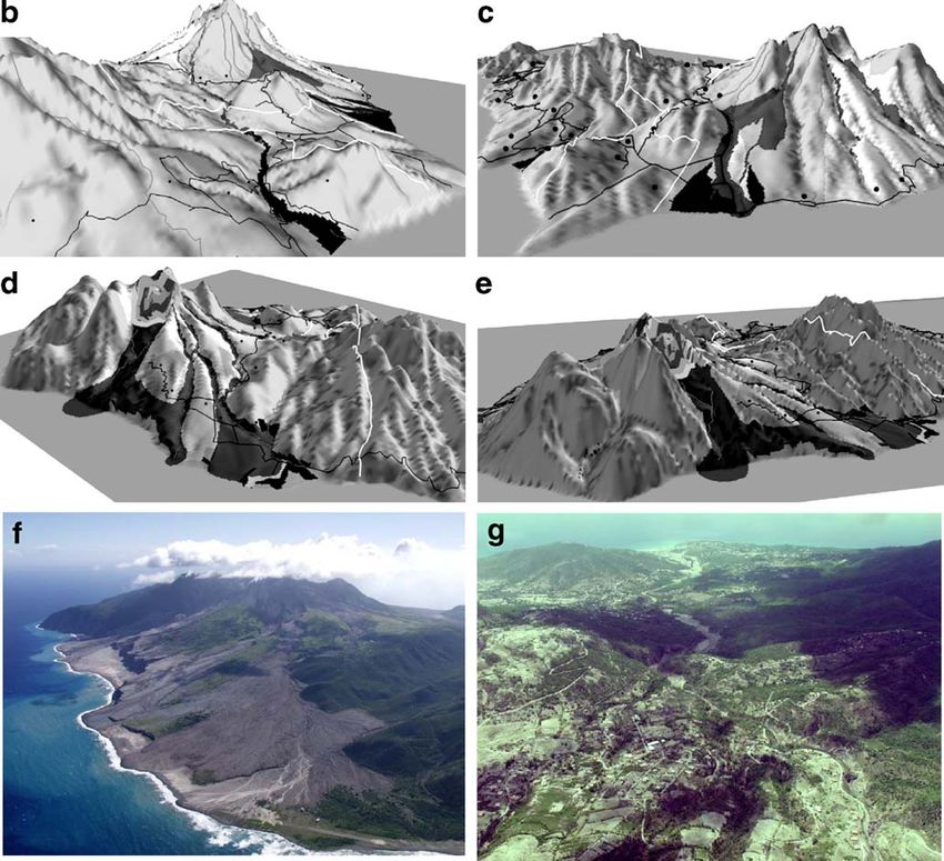
Fig. 2 a The contour map showing the risk zones and volcanic
deposits at the time of Survey (March 2004). On the original map
Map tools used contour lines were black; road lines were dark red; larger valleys were
shown with blue lines and the exclusion zone was pink bounded by a
One regular contour map, six 3D maps, and two perspective thick black line. The extent of surge deposits was shown in pale
yellow, pyroclastic flow deposits in red and lahar deposits in brown.
photographs of Montserrat were used during the interviews, Figure is adapted from Cole et al. (2002 p.233). b 3D view up the
all printed on A4 card (Fig. 2a–g). The contour map Belham Valley (looking SE). c 3D view from the SW looking NE over
(Fig. 2a) was the same as the regular topographic map used the western side of the island. d 3D view from the NE looking SW
by the MVO for all of their outreach activities. The map over the eastern side of the volcano. e 3D view from the south east
looking over the southern and eastern side of the island, (the pre–
used included colour (see legend to Fig. 2a for details) eruption digital elevation model of Montserrat used to create these 3D
however, for simplicity we have reproduced it here in black images (2b–2e) was kindly supplied by Geoff Wadge, University of
and white. Based on information available in January 2004, Reading). f Photograph of the eastern side of the island looking
this map included: contour lines; squares for the location of towards the volcano, taken in February 2004. Kindly supplied by the
Montserrat Volcano Observatory (copyright MVO). g Photograph of
the main villages and towns; roads; lines to indicate larger the western part of the island looking down the Belham Valley, taken
river valleys; a scale bar; a north arrow and the exclusion in February 2004. Kindly supplied by the Montserrat Volcano
zone. Volcanic deposits were also included. To discourage Observatory (copyright MVO)Bull Volcanol Fig. 2 (continued) affected by the volcanic activity and another view to show Questionnaire the western portion and part that had been most recently evacuated. This choice was governed by the availability of Respondents were asked questions that tested both basic images at that time and unfortunately slightly limited some map reading skills and also how this related to comprehen- of the questions associated with the photographs. sion and understanding of the volcanic hazards. The Six views of the 3D model were chosen as, in comparison justification for each grouping of questions is summarised to the flat contour map, one image did not completely show in Fig. 3 and the variables and themes used (other than the 3D relief of the whole island. The six images gave an demographic variables) in the statistical analysis are optimum representation of the island’s main features, as if summarised in Table 2. A full copy of the questionnaire is the island could be tilted and spun within the hands of the available from the first author on request. respondent. These images were two slightly oblique aerial As shown in Fig. 3 there is some overlap between the views—N/S and S/N perspective (not shown here) and main themes: map skills and locating, both test topographic therefore very similar to the view in the contour map; two skills although locating also tests knowledge of the oblique views of the western side (Fig. 2b, c); and two geographic area and ability to manoeuvre around the map. oblique views of the eastern side of the island (Fig. 2d, e). Map skills concentrate on the ability to decode mapped
Bull Volcanol

Table 1 Demographics of the survey respondents

                                         Map type

Map type                                 3D + photo                        Contour + photo                         Total maps + photo

Number of respondents                    19                                13                                      32a
Percentage                               59                                41                                      100
Age                                      %                 No              %                   No                  %                    No
70                                   42                8               15                  2                   31                   10
Total                                    100               19              100                 13                  100                  32
Education
 No formal qualifications                27                5               61                  8                   41                   13
 GCSE/CSE/CXC                            21                4               15                  2                   19                   6
 A levels/diplomas                       26                5               8                   1                   19                   6
 Higher Degrees                          26                5               15                  2                   22                   7
 Total                                   100               19              100                 13                  100                  32
Sex
 Male                                    53                10              46                  6                   50                   16
 Female                                  47                9               54                  7                   50                   16
 Total                                   100               19              100                 13                  100                  32
a
    Only those respondents who had answered sufficient questions to be included in the quantitative analysis are included in the demographic
    analysis. However the demographic breakdown of those involved in the developmental stage of the research is very similar to that shown here.

symbols. Locating and orientation are also closely related                    As the photographs cover a reduced area and contain
and it was surmised that ability to identify volcanic                      less volcanic information than the other two map types,
information would be related to abilities with the other three             the number of questions asked covering the ‘locating’ and
themes.                                                                    ‘volcanic’ themes had to be reduced. However, the compar-

Fig. 3 Description of the four task categories tested in this study
Bull Volcanol
Table 2 Variables used, overall themes and relationship to the interviewed (only with new questions so there would be no
different map types
learning effects through repetition), the other 11 interviews
Map type contained too many missing variables and were not
included in the statistical comparisons. The refined protocol
Skills tested Contoura 3Da Photosa
was used to interview a further 33 respondents. Data from
No. of respondents 13 19 32 two of these respondents was not included in the analysis
interviewed due to the absence of accompanying photographic data in
Variables one case, and the lack of light available to make the
The North Orientation X X X interview conditions fair in another. Thus, in all, data from
The South X X X 32 respondents was used for the final analysis.
The East X X X
The respondents were divided into two groups, one
The West X X X
group of 19 completing questions on the 3D maps followed
Any Hill Map Skills X X X
Any Valley X X X by the photographs, while the other group of 13 was
Roads X X X presented first with the contour maps followed by photo-
Island identification Locating X X X graphs. Different groups were chosen for the contour and
Location of X X 3D maps as it was thought that once they had filled-in and
respondents house discussed one map type with the interviewer, their
Current location X X responses could be biased for the next map type. It was
St Georges Hill X X X
hypothesised that the respondents would fare better with the
Garibaldi Hill X X X
Belham X X X
photographs (due in part to the findings by Plester et al.
Centre Hills X X (2002), who found that children performed better with
Silver Hills X X maps if they had seen photographs of the area first).
Plymouth X X Therefore, it was decided to start the interviews with a map,
St Patrick’s X X reducing the bias of a respondent orientating themselves on
Cork Hill Village X X X a photograph first. It was also hoped this would help the
Lees Village X X X interviews end on a more positive note. All the respondents
Old Towne X X X
completed one map type and the photographs.
Whites Ghaut X X X
Tuitts Ghaut X X X The interviews took place during March 2004, each
Paradise Ghaut X X X taking about 25 min and following the same protocol, with
Long Ground X X X one investigator asking the questions and marking down a
Harris Village X X X code on a prepared table and the other writing notes. A
Tuitts Village X X X code (Table 2) was employed in order to analyse answers
Spanish Point X X X statistically but it also meant that the respondent could not
The volcano Volcanic X X X
deduce whether they were answering correctly or not, thus
Information
reducing a learning bias and possible embarrassment.
Exclusion line X X
Pyroclastic Flows X X Interview notes were taken for all the respondents. As
Surge Flows X X well as complementing the quantitative part of the survey,
Volcano Ghautsb X X X these notes also provided a method of cross-checking
Tar River Valley X X X locations marked by the first investigator and helped in
a refining questioning techniques as time went on. The
These answers were encoded and given a numeric value during the
questionnaire: 1 = correct, 2 = close (within 500 m, unless the qualitative data were coded according to similar themes
topography was very different) and 3 = wrong (more than 500 m or and issues that respondents discussed by respondents when
misinterpreting topography). answering the questions and is presented in the discussion
b
Includes the valleys affected by pyroclastic and surge flows in the alongside the quantitative data, with direct quotes from the
photograph
respondents and the interviewer’s notes where relevant.
isons involving the photographs with the other maps only Statistical analysis
used the variables available to all (Table 2).
As this was an exploratory study, the interview protocol Although the data were normally distributed, it was decided
was developed and pre-tested with 12 respondents. From to use non-parametric tests due to the small sample size in
these trial interviews, a more robust protocol was developed the study. These tests provide a more conservative test of
for the remaining interviews. While one respondent was re- differences, giving results and relationships that are moreBull Volcanol
robust when significance is found. The ‘Wilcoxon Signed 3D maps vs. contour maps
Ranks Test’ (or ‘Wilcoxon Matched Pairs Signed Ranks
Test’) was used to explore the difference between the When the 3D and contour maps are tested against each
results of the use of the 3D maps and the photos, and also other, the placing of the two variables ‘Valley’ and
between the contour maps and the photos. This test is ‘Volcano Ghauts’ (valleys leading from the volcano) are
similar to the traditional t test, but rather than simply significantly more correct on the 3D map than the contour
comparing the means, it converts scores to ranks. map (Table 5). When examined as group variables, the
To investigate the difference between the contour and the overall task of ‘Map skill’ is found to be significantly easier
3D maps the ‘Mann-Whitney U test’ was employed as there for the respondents on the 3D map than the contour map
are two independent groups with a continuous measure of (Table 6).
map understanding. This is also a non-parametric alterna-
tive to the t-test, but it compares medians rather than the
means, which it converts to ranks and then tests whether the The pattern of spatial responses
ranks for the two groups differ significantly (Pallant 2001).
Both tests produce a Z-score similar to a t-score in the t test The patterns of correct and incorrect responses for five
and is an overall evaluation of rank differences that are used locations were mapped for the contour map and the
to estimate statistical significance. photographs (Fig. 4). The five locations shown are
important because they represent significant topographical
differences and places important to the edge of the
Results Exclusion Zone at the time of survey. The results plotted
include all those interviewed and not just those chosen for
Contour vs. photo the statistical analysis, although some respondents were
unable even to attempt to identify some of the locations.
A total of ten (from 33) tasks (variables) were carried out The mapping of the spatial responses in Fig. 4a, b do not
significantly more successfully on the photographs than on show a complete record of responses but rather illustrate the
the contour map (Table 3) and only the ability to point out pattern of ‘mis-location’ for the contour maps and the
north (marked on the map, see Fig. 2a) was significantly photograph. The comparison between the 3D map is not
easier on the contour map. When these variables are shown.
grouped into their overall themes, Map Skills, Locating Confusion over different landmark features demonstrates
and Volcanic skills are found to be significantly easier on clearly that some people were not interpreting the contour
the photographs than on the contour maps (Table 6). information correctly. For example, St. Georges Hill was
often placed within a valley and the Belham Valley placed
3D maps vs. photos on a hill. However, while locations were sometimes con-
fused (e.g. St. Georges Hill mistaken for nearby Garibaldi
Four variables are found to be significantly easier to place Hill, Richmond Hill or the Centre Hills), respondents were
on the photographs than the 3D map (Table 4) with no better able to identify topographic features using the
overall grouped variable being significantly easier on the photographs. In addition, people generally felt more
photos (Table 6). No variables were significantly easier on confident locating themselves on the photo than on the
the 3D maps than the photographs. map.
Table 3 Variables which indicate a significant difference between the contour map and the photographs
Orient. Location Map skills Volcanic info.
The St Garibaldi Paradise Belham Spanish Cork Roads A valley Tar River Volcano
North Georges Hill Ghaut Valley Point Hill Valley Ghauts
Hill
Z Sig. −2.121a −2.236b −2.828b −2.428b −2.887b −2.373b −1.994b −2.000b −2.530b −2.309b −2.121b
(2-tailed) 0.034 0.025 0.005 0.015 0.004 0.018 0.046 0.046 0.011 0.021 0.034
a
Based on negative ranks = contour better than photo.
b
Based on positive ranks = photo better than contour map.Bull Volcanol
Table 4 Variables which indicate a significant improvement between the 3D map and the photos
Locating Volcanic info.
Garibaldi hill Belham valley Whites ghaut Tar river valley
Z Sig. (2-tailed) −2.955 0.003 −2.181 0.029 −2.183 0.029 −2.194 0.028
Based on positive ranks = photo better than 3D map
Discussion Orientation
The ability to decode a mapped message into information The skill of being able to orientate oneself on a map or
and meaning is assumed to be a learned skill. However, it photograph or to identify compass directions was found to
cannot be assumed that all educated individuals will be similar for all the map types and photographs. No single
possess this ability, because of varying study interests, or method stood above the others with respondents scoring on
cognitive differences, such as that often noted between men average just over 50% of correct answers. Photographs
and women. In addition, the less well educated cannot be scored the highest percentage of correct answers (59.4%)
labelled as spatially unaware as they often have very and the 3D map the lowest (47.4%) but this difference was
complex understandings of their surrounding environment. not significant (Table 5). The only single variable to show
A correlation of 0.51 was identified between age and any significance was the ability for respondents to correctly
education (p=0.003). This reflects the ‘brain drain’ on locate ‘North’ on the contour map. This may be due to
Montserrat due, in part, to the volcanic crisis. It also mirrors people being more accustomed to viewing the island from a
a wider social situation found in many small islands and north–south perspective with the north at the top. However,
rural communities where the more gifted young leave to as they were not similarly able to locate the other compass
find better prospects and employment abroad, with an directions with such ease, this is more likely attributable to
inward migration of educated but older individuals to retire. the small compass rose in the top right side of the contour
Table 7 shows the variables from the questionnaire that map which was not present in the 3D maps or photographs.
correlate with the education of the respondents. Those who
have a higher education can more easily orientate them- Locating
selves on the photograph by identifying north and west
directions and also have an improved ability for ‘locating;’ The task of locating various well-known features around
(a) where they live; (b) Garibaldi and (c) Centre Hills on the island, from villages to valleys and hills, was easier for
the contour maps. When the grouped variables were respondents using photographs. Almost two thirds (62.5%)
examined, the only significant correlation with education of those tested obtained correct answers compared to only
is with the skill of Orientation on the photographs. As this 31.6% of respondents tested on the 3D maps and 23.1% of
grouped variable is not found to be significantly different those tested on the contour map. The average scores for the
between the three map and photograph types, it can be contour and 3D maps were the lowest for all the different
concluded that education is not a major influence on the group variable tasks (Table 5). This demonstrates that it was
understanding of the different map types. This is exempli- the task the respondents found most difficult on maps; in
fied by the fact that more educated people made up the contrast, it was significantly easier to do this correctly on
group that was tested on the 3D maps and these attained the photographs.
lowest percentage of correct answers. However, respondents were much more competent at
No correlations were found in the overall data to support identifying where they lived on contour maps (50% of
any gender differences noted by other researchers (Downs respondents as opposed to only 21% using 3D maps). This
and Stea 1973; Monmonier 1996). may indicate that respondents were used to seeing the
contour map of Montserrat and can remember where their
house is located on this shape, not that they were actively
Table 5 Variables with a highly significant improvement between the interpreting the map. This is demonstrated by the very low
3D and contour map
percentage of correct answers identifying the location of the
Map skills Volcanic info. interview using both the contour map (15%) and the 3D
Valley Volcano ghauts map (26%). No significant difference was found for these
variables between the two map types.
Z Exact Sig. (2-tailed) −3.197 0.001 −2.819 0.008
Using prominent features to locate and orientate them-
Based on positive ranks = 3D map better than contour selves on the map and reference themselves to otherBull Volcanol
Table 6 Percentage correct answers for each of the group variables and their significant differences
% Correct answers Significance of comparisons
Wilcoxon signed ranks Mann-Whitney u test
Group Variable Photo Contour 3D C vs P 3D vs P C vs 3D
Orientation 59.4 53.8 47.4 Z=−1.273 p=0.203 Z=−1.194 p=0.233 Z=−1.244 p=0.226
Locating 62.5 23.1 31.6 Z=−3.063 p=0.002 Z=−1.711 p=0.087 Z=−1.040 p=0.295
Map Skills 96.9 53.8 100 Z=−2.555 p=0.011 Z=−0.687 p=0.492 Z=−2.763 p=0.005
Volcanic – 76.9 78.9 – – Z=−1.298 p=0.194
Volcanic (photo—reduced variables) 96.9 61.5 94.7 Z=−2.536 p=0.011 Z=−1.443 p=0.149 Z=−1.808 p=0.071
Figures in bold are those which the statistical tests demonstrated had a significant difference
features and locations was a skill used by six out of the 16 himself and used Bransby Point as a locator although put
males. No females used this technique to answer the SGH (St Georges Hill) a little far north.
questions. Four males used this technique on the 3D maps A few respondents, both male and female, used real
and two on the contour map. One used the volcano, while locations and features in the surrounding environment
the other five used Bransby Point, a finger of land in the where the interviews were taking place to locate themselves
exclusion zone pointing out to the west. These male and then attempted to transfer this information to the maps.
respondents used the features to navigate themselves A large number of respondents had either not heard of
successfully around the map. Interview notes for Respon- the names of some of the valleys and villages or had
dent 3, for example, state that he initially mistook SGH [St forgotten where they were. This may be reasonable if the
Georges Hill] for Garibaldi [Hill] and then corrected respondents were new to the island and because of
Fig. 4 A comparison of the pattern of locational responses between the contour and photographs (underlying map is reproduced from Young
et al. (1998 p.3390))Bull Volcanol
Table 7 Correlation results for the influence of education respondents to interpret contours and therefore topography
Variable Group Correlation Significance on the traditional map. The qualitative observation notes
support this quantitative finding with many respondents
Photo—North Orientation 0.385 0.030p notably not using the topography on the map to locate and
Photo—West 0.358 0.044p identify features.
Contour—Live Locating 0.619 0.032p
When using the photographs and the 3D maps, respon-
Contour—Garibaldi Hill 0.575 0.040p
dents did not have to decode mapped symbols as the relief
Contour—Centre Hills 0.685 0.010p
‘Orientation’ 0.400 0.023p stands out much as it does in reality. This can also explain
why roads are easier for the respondents to interpret on the
photographs than the 3D maps. The roads were mis-
identified by respondents (5 from 32) who pointed to the
exclusion zone restrictions had been unable to explore contours and on one occasion the exclusion line. A further
certain areas of the island. However, as stated in the three respondents confused valleys with contours, roads and
methodology only those who had been on the island prior the exclusion line. It therefore seems imperative that if
to June 1997 were interviewed and therefore, this problem standard type maps are to be released to the public, then the
of ‘locating’ ran beyond the few relative newcomers marking of dissimilar linear features should be strongly
interviewed; not only identifying problems with map differentiated—e.g. that contours, roads and (exclusion
reading but also a cultural phenomenon of people limiting zone) boundaries must be plotted in clearly distinctive ways.
themselves to quite small areas on the island. Montserra- Occasionally, respondents would confuse prominent
tians have never liked travelling ‘distances’ and have deep features or colours for topography. For example, the west-
attachments to their home villages (Pattullo 2000). The ward pointing finger of land Bransby point or the markings
relevance of this becomes apparent for the theme of used to display pyroclastic flow deposits as the highest
volcanic skills and locating areas near the volcano. When points on the island. The mis-location patterns in Fig. 4 also
questioning people about the locality of certain valleys show this confusion, with respondents confusing the high
down which volcanic hazards flow, respondents, although point of the South Soufrière Hills as Plymouth, and the
recognising the valley name, commonly could not give a colours over the village of Spanish Point as the high ground
direction or location for the valley. Therefore, they did not of St. Georges Hill.
know if the dangers the scientists were talking about were
coming towards the north and the safe zone or the east, Volcanic information
west or south!
No significant improvement was found between the
“....[I have] never been to Long Ground or spent any
contour and the 3D map in terms of the interpretation of
time on the east side,”
the full range of volcanic information. Both maps yielded
Respondent 39, Montserratian, who has always lived on a similarly high percentage of correct answers with scores
the island. of 77 and 79% respectively, with no one map type
The mis-locations in Fig. 4 exemplify this pattern, with proving significantly better over the other. When the
respondents mixing up the valleys, hills and settlements. reduced variables are compared against the photographs,
Although some respondents were matching up the correct both the 3D maps and the photographs yield very
features or representations on the map, their inaccurate similarly high percentage correct scores of 94.7 and
locations show a difficulty with locating and orientating. 96.9% respectively. For the contour map, this drops to
61.5%. Therefore, there is a significant improvement
General map skills between the contour and the photographs’ ability to
communicate the volcanic information.
The ability for respondents to interpret topography was Respondents were asked to locate the markings on the
found to be significantly easier for those using the photo- map that represented pyroclastic flows, surges and mud
graphs and the 3D maps; both attaining very high average flows and also to discuss their location in relation to the
correct scores of 97% for the photographs and 100% for the topography; testing comprehension and knowledge but also
3D maps. This indicates that both of these formats are the application of that knowledge. Many of the respondents
easier to interpret in comparison to the contour maps where took some time deliberating because of confusion about the
a score of 54% was achieved. Although the 3D maps physical properties of these hazards and the different
obtained the highest score, no significant difference or geographic locations they affect. However, this can also be
improvement was found between them. This improvement attributed to difficulty in interpreting the colours, features
over the contour map is due to the almost total inability for and topography of the map.Bull Volcanol
Colour was a common factor which the respondents used Concluding comments
to try and interpret the mapped hazards, particularly the colour
red, which they commonly associated with the high temper- Future work
atures of pyroclastic flows and surges. The respondents were
trying to match up the colours they saw around them rather While piloting this work we attempted to ask respondents
than recognising them as false colour symbols and decoding to draw ‘mental maps’ of their area. Approximately eight
them relative to their topographical position. For example: respondents drew their own sketch map on a blank sheet of
paper. The respondents were told that a friend was visiting
“me thinks the red is the lava, the lava is like fire and
the island and needed a map to guide them from Salem,
the pyroclastic flow is like smoke”
(within the safe zone), to Plymouth, (within the exclusion
Respondent 21 zone). They were asked to mark out the safest route and the
areas or dangers to avoid. However, this was abandoned as
“where the red is danger”
after the map comprehension interview (the priority for this
Respondent 22 research) respondents were rapidly tiring and were gener-
ally unhappy to cooperate. The findings from our study
“the surge is the red colour because it is hot”
strongly suggest that the richer and more realistic informa-
Respondent 42 tion available on the aerial photographs were providing
Some respondents were able to use their knowledge to cognitive cues to the interpreter. In the absence of
decipher the patterns into topographic meaning and hazard respondents’ mental maps we can only guess at what these
identification, however many were not. cues were and whether there was some commonality to
A correlation between the ability to score highly on the them among respondents (e.g. Bransby Point was important
Volcanic Skills variable was found with the Map Skills and to some male respondents as a locating feature). Future
Locating variables for all map types indicating that in order work should therefore examine people’s cognitive maps and
to interpret the volcanic information people need to be able their proposed emergency escape plans using a dedicated
to locate themselves and decode the map symbols. A methodology. This could offer two avenues for improved
correlation for the two map types and the photographs was risk communication: (1) a comparison of their maps with
also found between the orientation variable and the those produced by the scientists could identify misconcep-
locating variables as those who can orientate themselves tions and problems to address; and (2) the mental maps
will be more able to locate themselves. can be used as the basis for the hazard maps, thus over-
Although most respondents were able to locate the coming problems with decoding issues, usability and also
exclusion line, when asked for the possible reasons for it increasing their efficacy at raising awareness by incorpo-
being located here, only two were able to relate its position rating the public’s needs, views and perceptions of the
to the terrain. The majority of the respondents persisted in local geography to produce trusted and user friendly maps
describing the exclusion line as the line separating safe and or GIS photo-maps.
unsafe areas, even after much prompting to expand and Although improved GIS mapping will aid communica-
describe why. This is an accurate but basic description, tion among volcanologists, it has been shown that during a
showing a lack of understanding and knowledge of the rapidly evolving crisis, emergency managers tend to rely on
relationship between the hazards and topography and why less technical options, sometimes preferring hand-drawn
some areas are dangerous and others safe. It also exem- maps to the more complex GIS versions (Alexander 2004).
plifies the problems highlighted above in map skills and an For example, following the Boxing Day Tsunami in 2004,
apparent inability to decode topographic information in technical difficulties forced emergency managers to aban-
order to explain the pattern of the meandering exclusion don their GIS maps in favour of hand drawn maps (Dr. Tom
line by many respondents. Mitchell, Institute of Development Studies, UK, 2005,
personal communication). Thus, it would be very valuable
Danger recognition future research to compare between the lay public,
emergency managers and the authorities the efficacy of
Two respondents actually re-evaluated their perceptions of GIS photo maps (photographs draped over DEM data) with
danger after looking at the photographs. Respondent 39 was the more simple oblique photographs, labelled to make
shocked when she looked at the aerial photograph of the them more ‘map like,’ and hand drawn maps. It would also
Belham Valley area as she could clearly see that the Valley be prudent to explore a similar interview aproach with
was on a direct path from the volcano down which hazards school children as modern educational methods are increas-
could flow. Previously she couldn’t understand why the ingly supplimented with graphical/computer imagery. This
Belham area had been evacuated. may mean that the younger generation could be moreBull Volcanol
familiar and comfortable with maps or photos draped over information to be interpreted in different ways. However,
3D visualisations of DEM’s. this exemplifies and reiterates the point that one approach
does not suit all situations. The notion that everyone can or
Implications for emergency management should understand traditional hazard maps, with education
the key to increased comprehension, should be rejected. At
Photographs were found to be significantly better than the the very least, evaluation of new hazards and risk maps
contour maps on three of the four key skills; Map Skills, must become usual practice so that they can be adapted and
Locating and Volcanic Skills. No significant difference was their efficacy measured. Ideally, improved methods should
found between the photographs and the 3D maps, although be developed with those at risk, to produce an effective and
the percentage of correct answers for the photographs in the trusted tool. However, if this means the production and use
Locating’ skill was almost twice that of the 3D maps, the of more than one map type (e.g. scientists continue to use a
variability of the other scores and the rigorous tests chosen more detailed topographic map), care needs to be taken to
reduced the apparent significance of the difference. The 3D maintain transparency and avoid any suspicion that infor-
maps were found to be significantly better than the contour mation is being withheld or the public map “doctored.”
maps for ‘Map Skills.’ Intstilling and promoting trust is as important for the
It can be concluded that for the sample tested, photo- management of the crisis as effectively communicating the
graphs are an improved method for the communication of geospatial hazard and risk information.
spatial hazard information. In a rapidly evolving crisis
situation, where there has been little preparation or planning, Acknowledgments The authors thank the people of Montserrat, for
photos can be quickly produced and annotated electronically their time invested in completing the survey. The MVO and staff are
or by hand. also thanked for their help as are Miguel Dorio and Wouter Poortinga
for their statistical advice and Iain Lake for his help with the GIS
This improvement of spatial comprehension with aerial maps. Thanks are due to the reviwers Dr Willy Aspinall and Dr Shane
photographs is similar to that reported in Handmer (1985) Cronin for their helpfull comments and advice and also to Tom Lowe
and Plester et al. (2002). Respondents did not have to and John McAneney for proof reading earlier drafts of this
decode contours, symbols or false colours and were able to manuscript. This work was supported by the UK NERC/ESRC and
carried out within the School of Environmental Sciences at the
filter their own information. As stated by Delucia (1978, in
University of East Anglia.
Handmer 1985, p84), a photograph “is much closer to
being a scaled down version of reality.” This is also shown
in the increased effectiveness of the 3D map compared to
References
the contour map for the general ‘map skill’ as respondents
do not have to decode contours.
Alexander DE (2004) Cognitive mapping as an emergency manage-
The locating task also revealed a limited knowledge of ment exercise. J Conting Crisis Man 12:150–159
the wider geography of the island confirming a Montserra- Asian Disaster Reduction Centre (2005) Community-based hazard
tian cultural phenomenon of people sticking to and limiting mapping: an effective tool to raise public awareness. In: Jeggle T
(ed) Know risk. United Nations publication, Tudor Rose, pp
themselves to quite small areas on the island. This was also
78–79
common with those who were new to the island preferring Aspinall WP, Loughlin SC, Michael FV, Miller AD, Norton GE,
compass directions rather than unrecognisable names of the Rowley KC, Sparks RSJ, Young SR (2002) The Montserrat
areas affected. Demographics did not have a significant Volcano Observatory: its evolution, organization, role and
activities. In: Druitt TH, Kokelaar BP (eds) The eruption of
influence on map comprehension, although some men were
Soufrière Hills Volcano, Montserrat, from 1995 to 1999. Geol
using notable topography to orientate themselves, which Soc London Mem 21:71–91
was a technique not used by women. Bryman A (1988) Quantity and quality in social research. Unwin
Many respondents also showed difficulty in demonstrat- Hyman, London
Clay E, Barrow C, Benson C, Dempster J, Kokelaar P, Pillai N,
ing an understanding of the properties of the hazards, their
Seaman J (1999) An evaluation of HMG’s response to the
topographic controls and defining the topographic position- Montserrat volcanic emergency, 2 vols. Evaluation Report
ing of the exclusion line, which was compounded by their EV635, Department for International Development, London
inability to decode the contours on the contour map. Cole PD, Calder ES, Sparks RSJ, Clarke AB, Druitt TH, Young SR,
Herd RA, Harford CL, Norton GE (2002) Deposits from dome-
However, the relationship between increased map compre-
collapse and fountain-collapse pyroclastic flows at Soufriere
hension and perceived risk is unknown and requires further Hills Volcano, Montserrat. In: Druitt TH, Kokelaar BP (eds) The
work; although a couple of respondents did demonstrate eruption of Soufrière Hills Volcano, Montserrat, from 1995 to
increased risk perception on viewing the photographs. 1999. Geol Soc London Mem 21:231–262
Cronin SJ, Gaylord DR, Charley P, Wallez S, Alloway BV, Esau JW
It is difficult to extrapolate the direct applicability of this
(2004) Participatory methods of incorporating scientific with
study to regions outside of the Caribbean as variations in traditional knowledge for volcanic hazard assessment on Ambae
the socio-cultural and geographic setting will cause mapped Island, Vanuatu. Bull Volcanol 66:652–668You can also read