Walking Strategy and Action Plan - NSW ...
←
→
Page content transcription
If your browser does not render page correctly, please read the page content below
The Walking Strategy and Action Plan is a supporting document to
                                    the Environmental Action 2016 – 2021 Strategy and Action Plan that
                                    was endorsed by the City of Sydney in March 2017. The City’s most
                                    up to date set of environmental targets and actions are contained in
                                    Environmental Action 2016 – 2021 Strategy and Action Plan.

Sydney2030/Green/Global/Connected

Walking Strategy
and Action Plan
Walking

          01/ Lord Mayor’s message                 01
          02/ Executive summary                    02
          03/ The walking scene                    05
          04/ Why walking counts                   09
          05/ Our ten targets                      17
          06/ Our four directions                  20
          07/ List of actions                      31
          08/ Consultation                         36
          09/ Governance and monitoring            37
          10/ References                           38
          11/ Appendix A – key walking routes      40
          12/
              Appendix B – Liveable Green
              Network (walking)                    42
          13/ Appendix C – main activity streets   44
Strategy and Action Plan 2015–2030

                                                                 We are creating a city that is
                                                                 convenient and inviting for
                                                                 walking by creating lively and

 Lord Mayor’s                                                    interesting streets, new walking
                                                                 connections, improving

 message                                                         wayfinding and renewing
                                                                 main streets
                                                                 Lord Mayor Clover Moore

 During consultation for Sustainable Sydney 2030, you told       The City of Sydney already has a number of policies and
 us you wanted a city that is safe and attractive for walking    strategies related to walking. The Walking Strategy and
 and cycling.                                                    Action Plan brings together all the actions and targets
                                                                 to deliver a more walkable and liveable city and a more
 For Sydney to remain globally competitive, it must have an
                                                                 effective transport network for everyone.
 integrated transport system which is reliable, efficient, and
 well designed. Walking is a healthy and environmentally
 friendly form of transport. The Walking Strategy and Action
 Plan aims to create a city centre and villages that are
 attractive, safe and interesting places for walking.
 By 2036 it is expected that 280,000 people will live in the
 City of Sydney and 570,000 people will work here. More
 people living and working in the city means increased
 pressure on transport infrastructure. We need to prioritise
 transport choices that help people to easily get where
 they need to go. Walking accounts for 92% of trips in the
 city centre but our city has not been designed with this in
 mind. Instead, a focus on wide roads and high speed limits
 means people are crowded on narrow footpaths and have
 to wait for long periods to cross the road.
 We need to provide greater priority, safety and amenity so
 people are encouraged to walk more often and to spend
 more time in our public spaces. The Walking Strategy
 and Action Plan outlines how we will encourage walking
 by improving wayfinding, encouraging a fine grain street
 network, creating lively interesting streets, improving ramps
 and footpaths and slowing down traffic.                         Clover Moore
                                                                 Lord Mayor

Sydney2030/Green/Global/Connected
Walking

                                                                 At some point we are all
                                                                 pedestrians. As such,
                                                                 streets should be welcoming

Executive                                                        to all of us.
                                                                 Jan Gehl, urban designer and architect

summary

Sydney is ideal for walking. It is a dense, compact and          We can also learn from other cities around the world
scenic city that enjoys a good climate.                          and build on our current work to remain internationally
                                                                 competitive and liveable.
Already, walking accounts for over 92% of all trips in the
city centre and plays a major role in the local economy          The City of Sydney supports walking as a mode of transport
and transport network.1 A total of 29% of City of Sydney         to meet the environmental, economic and social objectives
residents walk to work.2 In the future, walking is expected      set in Sustainable Sydney 2030 and Connecting Our City.
to become even more popular with the number of people
                                                                 Our overarching priorities for walking are to:
walking forecast to double between 2006 and 2030.3
                                                                 1. Make walking quick, convenient and easy
It is vital that we plan to accommodate this growth. We
need to make it quicker to walk, provide more space for          2. Make walking inviting and interesting
walking, create new connections through large street
                                                                 3. Make walking safe and comfortable
blocks and make it easier and more comfortable for
people walking.                                                  4. Create a strong walking culture
We also need to plan for universal accessibility to cater        This strategy includes ambitious but achievable targets to
for an ageing population, increasing numbers of families         meet these priorities. These targets are based on a review
with children living in the city, and people with mobility and   of trends and forecasts and will allow us to clearly track
vision impairment.                                               progress towards our achievements.
The centre of the city is about to undergo a major
transformation, with proposed light rail on George Street
and a pedestrianised section between Bathurst Street and
Hunter Street. This is an ideal time to focus on sustainable
transport modes.

                                                                 1 Transport for NSW, Sydney City Centre Access Strategy, 2013.
                                                                 2 Bureau of Transport Statistics, Journey to Work, 2011.
                                                                 3 City of Sydney, Connecting Our City: Summary Report, 2012.

                                                                                                Sydney2030/Green/Global/Connected
Strategy and Action Plan 2015–2030

 Our ten walking targets for 2030:

        Walking to make up one third of commuter
    1
        trips by City of Sydney residents

        Walking to account for 60% of local trips by
    2
        City of Sydney residents by 2030

        Reduce delay to walking times by 10% across
    3
        key walking routes

        Increase footpath capacity by 20% on
    4   average on main activity streets through
        planned upgrades

        Improve walking amenity by 10% on main
    5
        activity streets through planned upgrades

        All residents to be within a 10-minute walk
    6   (800m) of commercial/retail space suitable
        for essential daily needs

        Every resident to be within a three-minute walk
    7
        (250m) of the Liveable Green Network

        Reduce traffic related crashes involving people
    8
        walking by 50%

        Walking to make up 50% of trips to and from
    9
        late night precincts

        90% of residents feel safe walking in the day
   10   and night

Sydney2030/Green/Global/Connected
Strategy and Action Plan 2015–2030

Sydney2030/Green/Global/Connected
Strategy and Action Plan 2015–2030

                                                                      Walking is an easy, low impact
                                                                      and accessible form of transport

 The walking
 scene

 Sydney today                                                         We need to build on these figures by making walking more
                                                                      accessible to everyone and to do this effectively we must
 Traffic congestion costs metropolitan Sydney businesses
                                                                      take into account the changing demographics of Sydney.
 an alarming $5 billion per year, and this figure is expected
                                                                      More people, including families, are choosing to live in
 to increase to nearly $8 billion by 2020.4
                                                                      the city. Our population is also ageing, which means more
                                                                      people will need easy and accessible options for moving
 Walking plays a major role in minimising this congestion.
                                                                      around the city if driving is no longer an option.
 When people choose to walk it means there is one less
 person on the train, bus or road.                                    We need to design walking infrastructure now to cater
                                                                      for future requirements. This includes priority for people
 Walking is already a major mode of transport and means               walking, with good footpaths, easy connections, adequate
 of access in the City of Sydney as the figures in the table          lighting, places to stop, improved wayfinding, shade
 below reveal.                                                        and seating.
 In 2011/2012:
 In 2011/2012:
                                                                      Improving the city’s walking options will increase people’s
                                                                      feelings of social connection and inclusion, by making it
                                                                      easier for them to visit friends, go shopping, get to work
                                                                      and enjoy city life. It will also boost the health and wellbeing
                                                                      of people who live and work in Sydney, as well as those
                                                                      who visit the city.

 29% OF CITY OF SYDNEY RESIDENTS    42% OF PEOPLE WHO LIVE & WORK
 WALK TO WORK                       IN THE CITY WALK TO WORK

                                                                      Walking accounts for 92% of
                                                                      trips made within the city centre5

 69% OF WEEKEND TRIPS THAT          74% OF WEEKDAY TRIPS THAT START
 START AND END IN THE CITY ARE BY   AND END WITHIN THE CITY ARE BY
 WALKING                            WALKING

 Source: Bureau of Transport Statistics, Household Travel Survey      4+5T
                                                                          ransport for NSW, Sydney City Centre Access
 2011–2012 and Journey to Work 2011.                                     Strategy, 2013.

Sydney2030/Green/Global/Connected
Walking

                                                               When walking is prioritised,
                                                               all transport modes benefit
                                                               Brent Toderian, city planner and urbanist,
                                                               former chief planner Vancouver

Strategic context                                              City of Sydney framework
The City’s Walking Strategy is part of a broader policy        Local government plays a significant role in planning and
framework at a local and state government level.               delivering walking-related infrastructure. For example,
                                                               footpaths and parks are generally the responsibility of
NSW Government framework                                       local government. It is critical local governments plan
The NSW Government has developed a strategic                   and deliver walking infrastructure in a coordinated and
framework that helps guide the planning, design and            targeted manner.
delivery of walking-related infrastructure. This includes:     The key City of Sydney documents are:
The Long Term Transport Master Plan that outlines the          Sustainable Sydney 2030 is the City’s overarching strategy.
objectives and key actions to improve the NSW Transport        It sets out a vision for a more liveable and accessible city
System. Walking is highlighted as a critical mode of           and actions to achieve this.
transport in delivering an integrated transport system. The
focus for walking in this document is on public transport      The Liveable Green Network (LGN) is a program to develop
trips and the potential to shift short car trips, under two    a network of green corridors with lively streets that connect
kilometres, to minimise congestion and improve local           the city, village centres, major transport and entertainment
amenity and the environment.                                   hubs, cultural precincts, parks and open space. As part of
                                                               this, projects for footpath widening, lighting improvements
Sydney’s Walking Future details a two kilometre catchment      and landscaping began in 2012. The City currently invests
approach to prioritise investment in busy centres and          over $15 million per year on footpath upgrades, new
around public transport interchanges and how this              pedestrian crossings and additional footpaths.
approach will influence funding to local governments. It
outlines programs and policies to change travel behaviour      Connecting Our City aims to improve transport and access
and create a culture of walking across Greater Sydney.         to ensure Sydney remains globally competitive. For active
                                                               transport key targets are for 10% of local trips to be made
The Sydney City Centre Access Strategy is the first detailed   by bike and 50% on foot by 2030.
plan showing how people will enter, exit and move around
the CBD over the next 20 years. It outlines how all the        Statutory documents such as the Local Environmental Plan
transport modes will work together in the city centre to:      and Development Control Plan 2012 provide controls for
reduce congestion, provide for future growth and improve       development in the local area. They address how people
people’s experience. It identifies George Street as the        move around within development and the interface between
central spine of the city and prioritises the movement of      public and private property.
pedestrians and public transport along it. The strategy also
highlights the importance of improving safety for people
walking and proposed a 40km/hr speed zone within the
city centre.

                                                                                           Sydney2030/Green/Global/Connected
Strategy and Action Plan 2015–2030

 Our achievements to date                                        Road safety campaigns and initiatives. These have
                                                                 helped to contribute to a 28% reduction in traffic accidents
 The City of Sydney is committed to transforming the             involving pedestrians, from 327 accidents in 2009 to
 city’s walking environment. Some of our significant             235 in 2013.6
 achievements include:
                                                                 Comprehensive wayfinding. Legible Sydney, a
 The LGN. The City is delivering major walking infrastructure    pedestrian Wayfinding Strategy and Design Manual
 across the LGN including new road crossings and major           to ensure pedestrian signage is consistent and easily
 street upgrades.                                                understood. New signage will be rolled-out in 2015 will
 Transforming George Street. The City advocated for              assist people navigating the city on foot.
 pedestrianisation and light rail along the major thoroughfare   Revitalised city laneways. Newly activated city laneways,
 and has committed $220 million for public domain                such as Angel Place in the city and Kimber Lane in
 upgrades to ensure George Street is the premier street for      Haymarket, include public artworks and infrastructure
 walking in the city.                                            upgrades to encourage walking.
 Major upgrades to Pitt Street Mall. These include               Major public events. These include Sydney New Year’s
 upgrades to paving and new trees, seating, lighting and         Eve, Art and About Sydney, Vivid, Chinese New Year and
 awnings to improve the pedestrian experience.                   many local markets and festivals. Our public spaces host
 Upgrades to streets across the city. The City currently         a range of exhibits and installations during these events
 spends over $15 million per year on walking infrastructure.     which encourage people to walk and interact.
 This work includes footpath widening, laying new granite        A City Art Program. The program encourages artists
 paving and installing new lighting, trees and hedges.           to integrate art into our public spaces. The City recently
 Notable completed upgrades include Glebe Point Road,            developed a Culture Walks app. to allow people to discover
 Bulletin Place, Foley Street, Newtown Station precinct          the city on foot while learning about the history and stories
 and Cleveland Street. Significant projects scheduled to         behind public art pieces, neighbourhoods and specific sites.
 commence in 2015 include upgrades to Thomas Street
 in Chinatown.

                                                                 6 Centre for Road Safety, Interactive Crash Statistics: People in
                                                                   Crashes by Local Government Area, 2013.

Sydney2030/Green/Global/Connected
Walking

Traffic calming measures. These include new shared              Key partners
zones and low-speed environments to provide greater
pedestrian amenity and safety.                                  The City plays a key role in the delivery of walking
                                                                infrastructure and programs but we cannot deliver a
Careful planning in urban renewal areas. This ensures           walkable environment alone. A wide range of organisations
effective connections and safe and attractive public spaces     are involved in assessing, approving and supporting
are put in place.                                               walking infrastructure, including State Government
International conferences. In October 2014, the City of         agencies, neighbouring councils, non-government
Sydney co-hosted Walk 21, the world’s leading international     organisations, schools, universities, and private land
conference on walking and liveable communities. As a            owners and developers.
signatory of the Walk 21 Charter, the City is committed to
reducing the physical, social and institutional barriers that
limit walking.
Active Travel for Children. The City supports the
NSW Active Transport Charter for Children and runs four
programs annually targeted at children’s road safety.
A new Active Travel to Schools program will commence
in 2015–16.

                                                                                          Sydney2030/Green/Global/Connected
Strategy and Action Plan 2015–2030
Why walking
counts
Almost three quarters of people say they could walk
more.7 If we can encourage them to do so we will create The benefits of walking
a stronger economy, a cleaner environment, a safer and Economic
more equitable city and a healthier and more connected
society. Importantly, we will also reduce the congestion on –
–More space efficient – people can access places faster
our streets. and more easily
In 2007 the City engaged renowned Danish urban designer –
–Supports local business – people who walk more tend
and architect Jan Gehl to undertake a study of public to spend more time at local businesses
space and public life in central Sydney. Jan Gehl’s career –
–Enables direct access to businesses
has focused on improving the quality of urban life by re-
orienting city design towards people. He has collaborated –
–Encourages diverse land uses
with numerous cities around the world to help create better, –
–Improves employee productivity
more liveable urban centres, including Copenhagen,
London, Melbourne, New York and Moscow. Social
The study identifies several barriers to walking in the city, –
–Socially inclusive and equitable
including traffic congestion, low pedestrian priority, high – safe and flexible mode of transport
–A
traffic speeds, uninteresting streetscapes, lack of safety
and crowded footpaths. –
–Creates a sense of vibrancy in communities
Through the actions identified in this strategy, the City will –
–Improves quality of life through better social connections
address these and other barriers. This will result in a more –
–Improves physical and mental health
walkable environment and a number of associated benefits.
Environmental
–
–Improved streetscape environment
–
–Minimises local pollutants and greenhouse
gas emissions
–
–Reduces congestion
7 Transport for NSW, Sydney’s Walking Future: Connecting –
–Minimises noise pollution
People and Places, 2013.
Sydney2030/Green/Global/ConnectedWalking
A more efficient transport network
Congestion is a result of high demand and restricted A focus on increasing walkability can also improve the
space. Central Sydney and our village centres experience efficiency of the taxi network, an important part of the city’s
severe traffic congestion, particularly in peak periods. public transport system. Taxis provide a flexible option
A recent study suggests there may be savings to the for people with limited mobility, those who require extra
Sydney community for every kilometre not driven.8 By assistance or who need to travel to areas poorly serviced
increasing the amount of walking, we can reduce the by other transport options. But ad hoc stopping by taxis
significant cost of congestion. This means the road network causes congestion, especially in the city centre. Effective
is more reliable and the local environment is cleaner. walking routes and good wayfinding can encourage people
to walk to a rank rather than hail a taxi.
Good walking conditions also encourage visitors who
arrive by car to stop and park once, then make multiple
journeys on foot, rather than driving short distances
Traffic congestion costs between destinations.
Sydney $5 billion per year9
An efficient public transport network relies on an efficient
walking network. Where direct walking routes and good
priority are provided, people can walk further in less time.
The resultant increase in public transport catchments
means fewer stops are required and overall travel times
are reduced.
8 PricewaterhouseCoopers for PCAL and DEECW, Estimating the
Benefits of Walking: A Cost Benefit Methodology, 2010.
9 Transport for NSW, Sydney City Centre Access Strategy, 2013.
Sydney2030/Green/Global/ConnectedStrategy and Action Plan 2015–2030
People who walk and shop
locally visit most often – walking
is good for local business
Mode split and trip distance 2010/11 Retail
100% Other Walking is critical to the economic success of our city and
village centres. The relationship between transport choice,
90% shopping frequency and retail spending has been the
Taxi
subject of national and international research, with notable
80%
studies by Transport for London (TfL) and the National
70% Ferry Heart Foundation in Australia.
This research shows that investing in the walking
60% Vehicle environment boosts local business activity. While people
passenger walking often spend less money on average per visit to
50%
a local business, studies show they visit more often and
Vehicle spend a greater amount over a longer time period.10+11
40% driver
Train
30%
On average 60% of people travel
20%
Bus to the city’s main shopping
10% streets on foot12
Bicycle
0%
Walkable shopping areas are often more economically
m m m
1k - 5k 2 0k Walk only successful and have higher commercial and residential
to 01 1-
Up 2. 0.
0 land values. Large retail companies use footfall (the number
1 of people entering a shop or shopping area on foot) to
Source: Bureau of Transport Statistics, Household Travel estimate the amount of business a space may generate
Survey 2010–11 and rents are then based on this figure.
A stronger economy
Walking does not, generally, require any special equipment,
it is free and gives people a large amount of control over 10 Litman, T. Economic Value of Walkability, 2014.
the route they take. As such, it is one of the most cost-
11 Clifton, K. et al. for OTREC, Consumer Behaviour and Travel
effective modes of transport for short trips. There are also Mode Choices, 2012.
many other economic benefits.
12 Directional Insights, Customer Intercept Survey Detailed
Reports for Surry Hills, Oxford Street and Harris Street, 2014.
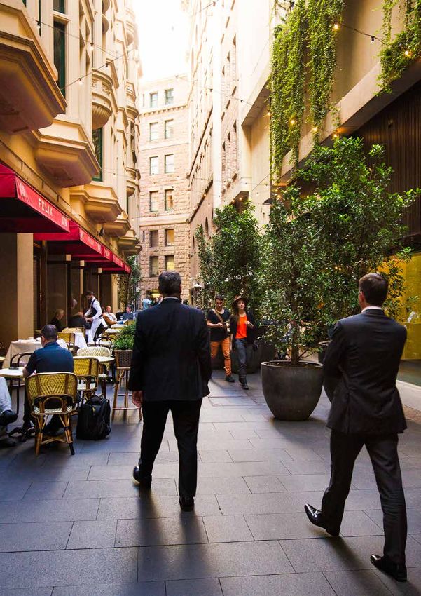
Sydney2030/Green/Global/ConnectedWalking
More people would walk
if it were easier, more direct
and safer
Sydney’s Pitt Street Mall is now one of the world’s Residential
most valued retail areas ($7,250 per square metre per
Good walking infrastructure has been proven to increase
annum) due in part to public domain upgrades and
residential property values. Property professionals use
pedestrianisation.13 Despite these high rents, many
walkability ratings for property valuations, as illustrated in
retailers have relocated to Pitt Street from elsewhere in
the online service walkscore.com which lists properties
the city, illustrating the success of the area. Retailers are
alongside their walkability scores, or the ease of access to
also anticipated to relocate to George Street due to the
vital services and activities in the area through walking. The
pedestrianisation.14
website is widely used by researchers, people searching for
The longer people spend in an area, the more likely they a home and property professionals alike. A US study found
are to spend money. By upgrading streets to make them each walkscore point was associated with a US $700–3,000
more attractive and inviting for walking and lingering in we increase in value.17
can help strengthen the economic performance of our city
and village centres.
Melbourne and New York retail and walking
A study in Melbourne, in the City of Yarra, revealed that
while locals who walk to the main shopping streets
spend about 50% less per visit, they make up 75%
of the spend on local retail and services.15 The study
observed that the ‘non-drive in’ spend is always bigger
than anticipated.
After improving the local walking environment in a
number of areas, the New York City Department of
Transport analysed the economic impact. The revitalised
shopping strip of Colombus Avenue on the Upper West
13 + 14 Savills Research, Spotlight Sydney CBD Retail August
Side experienced a revenue increase of 20% compared
2014, 2014.
to an average 9% growth elsewhere in the borough.
15 Tolley, R. for the National Heart Foundation, Good for Busine$$:
The Hub in The Bronx, a busy transport interchange, The Benefits of Making Streets More Walking and Cycling
experienced a retail sales increase of 50% compared Friendly, 2011.
to only 18% for the wider area after the department 16 NYC Department of Transportation, The Economic Benefits of
installed new walking signals and crossings.16 Sustainable Streets, 2013.
17 Cortright, J. for CEOs for Cities, Walking the Walk: How
Walkability Raises Home Values, 2009.
Sydney2030/Green/Global/ConnectedStrategy and Action Plan 2015–2030
Tourism A cleaner environment
Tourism is a vital industry for Sydney. Spending from Walking can help alleviate the existing burden of congestion
international and domestic visitors makes up 20–25% of our on roads and public transport.20 The Australian Government
city’s retail turnover, and Sydney’s tourism industry helps estimates that in 2010 the Australian road transport sector
support more than 10,000 businesses.18 was responsible for greenhouse gas emissions totalling
Tourists to Sydney explore mostly on foot. The City’s 78.7 million tonnes of direct carbon dioxide. This is
research shows tourists use George Street, but they projected to rise to 90.3 million tonnes by 2020.21
find it difficult to navigate the city and connect to other Cars are responsible for approximately half of this figure.
destinations from there. By improving the walkability The average car carrying 1.2 passengers emits 302 grams
of the city we will support the tourism industry and of carbon dioxide equivalent per passenger kilometre.22
our businesses. By comparison, average emissions of people walking
Public health is negligible. A shift away from private vehicle use and
towards walking could significantly curb air pollution in
The economic implications of increased walking on health local areas and improve air quality in Sydney.
services are significant. The Australian Government
estimates that physical inactivity costs the national
economy $13.8 billion a year. Investment in walking Motor vehicle exhaust
infrastructure has been shown to deliver a net health benefit
of 144 cents for each kilometre walked.19 More people
emissions are responsible for
walking means a healthier population, reduced rates of over 70% of the nitrous oxide
absenteeism at work and less burden on the health service.
and over 38% of the volatile
organic compounds in Sydney23
Walking is the most
Research shows that when greenhouse gas emissions,
environmentally friendly noise reduction and improved air quality are considered
mode of transport together, the value of investing in active transport-related
infrastructure is about 5.9 cents per kilometre travelled.24
18 City of Sydney estimate.
19, 21–24 Department of Infrastructure and Transport, Walking,
Riding and Access to Public Transport: Draft Report for
Discussion, 2012.
20 AECOM for City of Sydney, Economic Evaluation of Pedestrian
Improvements, 2011.
Sydney2030/Green/Global/ConnectedWalking
A healthier population In 2011–12 over 60% of the
If current trends continue, by 2025 close to 80% of the
Australian population will be overweight or obese.26 This is a
Australian population was
significant problem, attributed in part to a sedentary lifestyle either overweight or obese25
and transport systems that discourage walking.
Walking is an easy way to increase activity throughout
the day and minimise the effects of a sedentary lifestyle.
Research shows people who participate in regular physical
activity have less chance of developing heart disease,
stroke, type II diabetes, high blood pressure and high
cholesterol, and are less likely to be obese.27
Walking is also linked to lower incidences of poor
mental health and may help alleviate stress and anxiety
related disorders.28
Encouraging walking at work
The Global Corporate Challenge is an annual event
that encourages participants to walk more over a one
hundred day period. Participants receive a pedometer
and record their daily steps, tracking progress against
other participants. Observed health benefits for one
large organisation included:
– 89% of participants reported improved overall health
and wellbeing
– 62% of participants reported reduced stress levels 25 ABS, 4338.0 – Profiles of Health, Australia, 2011–13.
– 61% felt their energy levels improved 26 Department of Human Services, Future Prevalence of
Overweight and Obesity in Australian Children and Adolescents,
– 77% exceeded the recommended 10,000 steps 2005–2025, 2008.
per day29
27 + 28 C3 Collaborating for Health, The Benefits of Regular
Walking for Health, Wellbeing and the Environment, 2012.
29 Global Corporate Challenge, AstraZeneca Case Study, 2013.
Sydney2030/Green/Global/ConnectedStrategy and Action Plan 2015–2030
A safer, equitable and more connected society 40% of people report feeling
Safety unsafe on empty streets30
Safety is an important consideration when walking around
city streets. Greater perceived and actual safety is a key
benefit of a more walkable environment.
In 2013, 235 crashes occurred in the local area between
vehicles and pedestrians, of which one was a fatality. The
chart below shows the degree to which pedestrians are
A total of 87% of residents feel safe walking in their local
represented in road crashes.
area in the day, however this figure drops to 73% at night.31
Reducing speed limits and prioritising walking can address Whether the risk to personal security is perceived or real,
and lower these accident statistics. people are more likely to walk where they feel safe.
Around 40% of respondents to a City survey said the
People in crashes – Sydney LGA 2013 biggest factor that makes them feel unsafe in the public
domain is a lack of other people.32
It is crucial that Sydney is a safe city for residents, workers
and visitors.
Pedestrian 25%
Pedal Cyclist 15%
Passenger 10%
Motorcyclist 23%
Driver 27%
30 City of Sydney, Household and Resident Survey 2011: Data
Summary Report, 2011.
Source: TfNSW Centre for Road Safety
31+32 City of Sydney, Household and Resident Survey 2011: Data
Summary Report, 2011.
Sydney2030/Green/Global/ConnectedWalking
Equity
Key barriers to walking:37
Walking is the most equitable form of transport, for short
trips, available to people of all ages, incomes and locations.
–Distance
The average cost of transport for an Australian family is –Time
about 16% of their total income and this could be reduced
by choosing to walk for short trips.33 –Terrain
Research from the NSW Bureau of Transport Statistics –Carrying heavy bags
indicates car ownership and licensing of drivers in the state
is declining. Approximately 10% fewer people in their 20s
–Lack of motivation
held a driver’s licence in 2009 compared to 1998 and many –Poor quality footpaths
people are choosing not to own a car.34
–Multi-destination/purpose trip
In the City of Sydney, approximately 35% of households do
not own a car compared to almost 12% of households in –Habit
greater Sydney.35 –Safety and security
Connections
Attractive and well-designed streets encourage more Walkable environments maximise access to education, jobs
people to walk. This leads to greater opportunities for social and services. Walking is a reliable form of transport and is not
interactions, which allow people to become more involved contingent on getting the right service or avoiding peak hour.
in their local community.
In neighbourhoods with higher traffic volumes and fewer
people walking, residents can feel more detached and
show less concern for their local environment. Conversely,
UK research shows that when people spend more
time walking their local streets they develop a stronger
attachment to their neighbourhood.36
33 ABS, Household Expenditure Survey, Australia: Summary of
Results: 2009–2010, 2011.
34 ATRF, Conference Proceedings, Why Are Young People Driving
Less? Trends in Licence-holding and Travel Behaviour, 2010.
35 Profile.ID, Community Profile City of Sydney: Number of Cars
per Household, 2011.
36 Dobson, S., Sustaining Place Through Community Walking
Initiatives, 2011.
37 Transport for NSW, Sydney’s Walking Future: Connecting
People and Places, 2013.
Sydney2030/Green/Global/ConnectedStrategy and Action Plan 2015–2030
We will be accountable for
creating a more walkable
environment
Our ten
targets
The City has developed targets for walking efficiency, Mode of transport for employed residents
capacity, amenity and safety which are ambitious
but achievable. They are based on a review of trends and 2011 2030
forecasts, and will enable the City to clearly track progress % %
towards our achievements. Train
We will collaborate with key agencies to meet these Bus
targets, including Transport for NSW and Roads and Ferry 37 47
Maritime Services.
Tram
1. Walking to account for one third of Taxi
commute trips by City of Sydney residents Car driver 10 (target from
by 2030 Car passenger 30 Connecting our
Motorbike/scooter City)
Current rate: 29%
Data source: Bureau of Transport Statistics Journey to Truck 0 0
Work data 10 (target from
Note: Green Square will see the biggest rates of residential Bicycle 4 Connecting our
growth in the local area, with an estimated 60% of residents City)
working in the inner city. Due to the distance between Walk only 29 33
Green Square and central Sydney, the proportion of people Total 100 100
walking to and from work may be lower, and this will impact
our overall data. Source: Bureau of Transport Statistics, Journey to Work 2011.
Sydney2030/Green/Global/ConnectedWalking
2. Walking to account for 60% of local trips 4. Increase footpath capacity by 20% on
by City of Sydney residents by 2030 average on main activity streets through
Current rate: 47% on weekdays and 43% on weekends planned upgrades by 2030
Data source: Bureau of Transport Statistics Household Current data: existing capacity
Travel Survey Data Data source: City of Sydney, measured in square metres
Note: The main activity streets are identified in Sustainable
Local area purpose of travel (trips %) Sydney 2030. All streetscape upgrades will apply the City’s
streets design code.
Commute 20%
ork related
W 5. Improve walking amenity by 10% on
business 7% main activity streets through planned
Education/childcare upgrades by 2030
6%
Current rate: to be collected
Shopping 18%
Data source: local area perception surveys
Personal business 7%
Note: To be measured before and after key streetscape
Social/recreation 27%
upgrades.
Serve passenger 7%
Other 8% 6. All residents to be within a 10-minute walk
(800m) of commercial/retail space suitable
for essential daily needs by 2030
Source: Bureau of Transport Statistics, Household Travel Survey 2010–11 Current rate: 94%
Data source: City of Sydney Mapping Data
Note: A 10 minute walk is considered a reasonable
3. Reduce delay to walking times by 10% distance for most people to walk comfortably. Essential
across key walking routes by 2030 goods and services include convenience stores, health
Current rate: to be collected services, schools and childcare. Planning will ensure
sufficient space is suitable for essential services.
Data source: Walking surveys
Note: Key walking routes offer the greatest opportunities
for improvement. These are detailed in Appendix A.
Sydney2030/Green/Global/ConnectedStrategy and Action Plan 2015–2030
7. Every resident to be within a three-minute 10. 90% of residents feel safe walking in the
walk (250m) of the LGN day and night by 2030
Current rate: 91% Current rate: An average of 80% of people feel safe or
unconcerned at present
Data source: City of Sydney mapping data
Data source: City of Sydney surveys
Note: The LGN will connect the harbour foreshore, harbour
parklands, and Moore, Centennial and Sydney parks by Note: More life in the city makes it a safer place for
2030. Development in key urban renewal areas will include everyone, and contributes to the creation of vibrant,
new through-site links and open spaces. lively places.
8. Reduce traffic-related crashes involving
people walking by 50% by 2030
Current rate: 235 crashes in 2013
Data source: NSW Centre for Road Safety
9. Walking to account for 50% of trips to and
from late night precincts by 2030
Current rate: 37%
Data source: City of Sydney surveys
Note: More people leave late night precincts by walking
than arrive by walking. This indicates potential growth in the
number of people walking to late night precincts.
Sydney2030/Green/Global/ConnectedWalking
Our four
directions
The City will focus on four major ways to encourage walking Direction 1.
in the city. These have been identified through a wide-
ranging review of domestic and international research, Make walking quick, convenient and easy
evidence and case studies. People will choose to walk when it is quick, convenient
Our four directions are: and easy. The urban environment must have clear and
consistent signs, and direct and complete walking routes.
1. Make walking quick, convenient and easy
Priority for people walking
2. Make walking inviting and interesting
Over the past 50 years many of our streets have been
3. Make walking safe and comfortable
designed for vehicles, with very little focus on pedestrians.
4. Create a strong walking culture Intersections along major routes into the city give vehicles
priority over pedestrians. Wait times for pedestrians at traffic
Each direction is underpinned by a number of actions.
lights can be lengthy and crossing times short.
A full list of these actions, broken down into ongoing, short,
medium, long-term timeframes provided at Section 7 of The Public Spaces Public Life Study by Gehl Architects
this document. found that waiting contributed up to 50% of total walking
times. This is a major disincentive to walking in the city.39
What is important for
walking trips:
– Connectivity and reduced
delays
– Pedestrian safety and personal
security
– Health and wellbeing benefits
– Supporting facilities, e.g.
weather protection, wayfinding
and end of trip facilities38
38 Transport for NSW, Sydney’s Walking Future: Connecting
People and Places, 2013.
39 Gehl Architects, Public Spaces, Public Life Sydney, 2007.
Sydney2030/Green/Global/ConnectedStrategy and Action Plan 2015–2030
Percentage of walking time spent waiting at traffic lights in the city centre
17%
Waiting time
30%
Waiting time
38%
Waiting time
52%
Waiting time
33%
Waiting time
19%
Waiting time
0 0.125 0.25 0.5 0.75 1
Kilometres
Source: Gehl Architects, Public Spaces, Public Life Sydney, 2013.
PERCENTAGE OF WALKING TIME SPENT ON WAITING AT TRAFFIC LIGHTS TEST WALKS
Sydney2030/Green/Global/ConnectedWalking
Complete networks
Prioritising walkers
The City is already working to provide complete pedestrian
Improving pedestrian priority and amenity is vital for links through delivery of the LGN. The LGN aims to provide
encouraging more people to walk. Central Sydney’s a comprehensive and legible pedestrian and cycle network
network of underground walkways, connecting Town that connects people to the city centre, village centres and
Hall Station to the QVB and through to Pitt Street Mall, is neighbourhoods, as well as to public transport, education
extensively used by pedestrians as it provides a quicker and cultural precincts, major parks and recreation facilities.
route across the city than at street level, which involves The intention is to provide an alternative transport option to
long waiting times to cross busy streets. the car, particularly for short trips. The LGN project involves
Countdown timers, which display either the time left to infrastructure delivery, public space design, promotion of
wait before people can cross or the time left to complete the network and landscape treatments. Delivery of the LGN
the crossing, are used in cities around the world. Their is an ongoing project.
use can help people make informed decisions. Roads We are also providing new links in our urban renewal areas
and Maritime Services initiated a trial of countdown to ensure more direct routes and shorter walking distances.
timers in November 2014 at six busy intersections in the Some areas have incomplete links and indirect routes due
CBD. The results are expected to be released in 2015. to the design of the traffic network. For example, some
The Austrian city of Graz has trialled crossings which traffic lights do not have pedestrian signals and do not
remain on the pedestrian green phase by default and allow people to cross legally. Connectedness requires a
only switch to ‘don’t walk’ when a car approaches.40 network of quality links, therefore the City will continue to
fill in these gaps to make routes more direct and provide
infrastructure where it is currently missing.
Sydney already has a number of different pedestrian priority
measures in place, including shared zones and zebra
crossings. However, there is scope to work with the NSW New links
Government to increase pedestrian priority and work to
In 2014 the City created a pedestrian link providing
implement solutions and technologies.
more direct access to Sydney Park from Coulson
Street in Erskineville. The link makes it easier for people
to access open space and parklands and reduces
the walk time from parts of Erskineville to St Peters
40 Eltis Mobility, Case Study: Green Wave Increases Safety and train station. This is an example of how a relatively
Reduces Waiting Time for Graz Cyclists and Pedestrians simple infrastructure investment can creates a better
(Austria), 2011. connection and encourage walking.
Sydney2030/Green/Global/ConnectedStrategy and Action Plan 2015–2030
Wayfinding
Improving legibility
Sydney’s street network is not a simple grid. It can be hard
to navigate and the most direct route is often not apparent. In 2012 the City of Sydney adopted Legible Sydney,
a wayfinding strategy that aims to make navigation in
When people perceive walking to be difficult they are the city easier. Components include a Design Manual,
more likely to take a car or a taxi. They may also feel signage, maps, digital applications, visitor information
unsafe or uncomfortable. We will encourage walking by centres and public domain improvements. The
providing a legible street network and comprehensive wayfinding kit includes pylons, flags, surface mounted
wayfinding information. maps, tactile indicators and destination markers
Clear wayfinding information is particularly critical for for City owned community buildings and other key
people who are new to an area and do not have access to destinations. A pilot project was undertaken in October
mobile technology or for people with vision impairment. 2014, with ongoing roll-out across the City to follow
from 2015, beginning with the city centre. The roll-out
In urban renewal areas, such as Green Square and the will incorporate refinements based on outcomes of
Ashmore Precinct, the City is creating new streets with a pilot testing.
clear hierarchy, placing high quality architecture on corner
sites and maintaining views to landmarks to provide a clear Technology can also be used to assist people with
sense of place and assist navigation. These principles are wayfinding. Numerous websites such as Walkit.com
also used to guide new infill development in existing areas. offer route planning tools. Users enter a start point and
destination and the tool calculates direct, quiet and
low pollution routes. Some websites also offer circular
routes from a fixed point, which can be used to plan
recreational walks.
Sydney2030/Green/Global/ConnectedWalking
Direction 2. Attractive and interesting places
Delivering distinctive and attractive places, or placemaking,
Make walking inviting and interesting is a critical component of creating an inviting and
People will choose to walk along routes that are visually interesting walking environment. Jan Gehl’s Public Spaces,
interesting and where there are a variety of things to do Public Life study found that many spaces in the city centre
and see. were similar in size and function and lacked distinction.
Place-specific treatments whether in terms of distinctive
Ways to make a place interesting and enticing to walk in, lighting or artwork are ways to give places a unique sense
walk through and to linger in, can include encouraging of identity.
business activity at street level and, where appropriate,
installing public art, providing landscaped areas and well- Outside of our main activity streets, there are lots of
designed street frontages and entries to residences. placemaking opportunities. A recent example is the
revitalisation of Kimber Lane in Chinatown. Once a
Lively streets neglected and disused alleyway, Kimber Lane has
Successful walkable cities balance footpath space to allow been transformed into a meeting place and popular
freedom of movement alongside vibrant street activities. thoroughfare using a combination of paint, seating and
suspended bespoke art work with ties to Aboriginal and
De-cluttering is an important part of this balance. We can Chinese history.
achieve this by consolidating street signage and furniture
and placing these in consistent locations. Appropriate Another way we can encourage people to walk, particularly
placement of furniture allows people to stop and spend in their local neighbourhood is through temporary street
time in public spaces, adding vibrancy and activity to the closures and activations. Street closures have proven
street. The City’s Street Design Code provides guidelines successful in cities around the world. Transport for NSW,
on where street furniture should be located based on through its walking strategy, Sydney’s Walking Future,
research and analysis of best practice and standards. has committed to developing guidelines for a state-wide
Well designed buildings and active street frontages are an community street closure initiative and the City will work
equally important part of the streetscape that help create closely with the NSW Government to progress this work.
lively and interesting places to walk in and visit. The City will
continue to encourage this through its planning controls.
Sydney2030/Green/Global/ConnectedStrategy and Action Plan 2015–2030
The City’s planning controls aim to create a walkable built
Temporary initiatives to encourage walking environment. These principles are particularly evident
Pop-up events, festivals and playful activation projects in the masterplanning of urban renewal areas such as
are ways in which cities can create inviting places and Green Square and major developments such as the work
encourage people to walk more. Art and About Sydney done in and around Harold Park, including the Johnston’s
is an annual festival where public art is displayed in Creek Master Plan. This includes breaking up large
streets, laneways, parks and squares across the city. blocks of land by providing through-site links for greater
The event encourages people to spend more time permeability, restricting parking and providing a human
enjoying the city’s public spaces on foot. scale to developments.
As part of their Bondi Junction Complete Streets
project, Waverley Council piloted two temporary pop-
up projects, Jigsaw and Urban Lounge. People were
encouraged to spend time in these public spaces with
games to play, places to sit and even power points to
charge laptops and phones.
Other temporary treatments seen around the world
include rainbow crossings, hopscotch walkways and the
famous Piano Staircase, which transformed the stairs
leading out of the Odenplan subway in Stockholm,
Sweden, into a giant functioning piano keyboard.
The Make Way for People initiative by the Chicago
Department of Transportation used temporary furniture,
paint and planting to transform disused parking
stations, alleys and plazas into interesting and vibrant
public spaces. Activating these spaces improved safety,
promoted walking and improved the local economy.
Sydney2030/Green/Global/ConnectedWalking
Direction 3. The City will continue to prioritise walking as far as possible
within current guidelines. For example, to install a zebra
Make walking safe and comfortable crossing, a local authority must also demonstrate that
the relevant intersection meets certain criteria including
People will avoid walking where they feel unsafe or minimum vehicle and pedestrian numbers.
uncomfortable. This refers equally to personal security
and road safety as well as to exposure to the elements. In May 2014 the NSW Government announced the creation
It is important to design environments with this in mind. of a 40km/hr speed limit zone in Central Sydney. The zone
Improving the walking environment is important to is bounded by Hay, Kent, Pitt and Castlereagh Streets and
encourage more people to walk, but also to make it more will connect to the existing 40km/hr zone in The Rocks. The
pleasant for those already doing so. City first endorsed a proposal to introduce 40km/hr speed
limits in 2004 and has advocated for this ever since. The
Road safety City will work with the NSW Government to implement the
Safety for people is a top priority for the City. Walking is new zone and improve pedestrian safety.
considered one of the safest modes of transport. The City To improve general pedestrian safety, amenity and
designs the public domain to support walking, in most connectivity, the City has closed a number of roads. For
cases, this means designing a low-speed environment. It example, the closure of part of of Defries Avenue in Zetland
also means that where different modes use the same space to create a public plaza and to enhance the pedestrian
(for example, shared zones and shared paths) safety for all environment. The City continues to explore options for
users is a critical design consideration. road closures.
Shared paths are used where there is limited space to
provide separate walking and bike infrastructure. The City
designs shared paths to create slow zones and safe places
for people walking and riding. The City runs a Share the Path
program for both groups to educate them on how to use
shared paths safely and considerately. The program also
tries to impart the message of being alert and not distracted
by music or smart devices when walking or riding.
Slower vehicle speeds are a major factor in encouraging
safe and welcoming walkable environments. Speeds
can be lowered through changes to the speed limit or
through traffic calming measures such as narrowed lanes,
landscaping, crossings or refuge islands. Reducing the
width of traffic lanes can make crossing the road safer
for walking, especially for older people or those with
reduced mobility.
Sydney2030/Green/Global/ConnectedStrategy and Action Plan 2015–2030
Personal security Comfort
The design of buildings has a significant effect on how People will factor in comfort when choosing whether to walk
safe a place feels. Research by the City revealed that an or not. Exposure to rain or extreme heat, excessive noise
average of 80% of residents feel safe walking in their local from fast moving traffic, or strong winds, for example, will
area day and night. Designing and delivering places where act as a disincentive to people walking. This is illustrated
people feel safe is critical. by the fact that on rainy days the inner city public transport
network is placed under pressure due to extra demand
Building design can improve the safety of an area by from those who may normally walk or cycle. Equally, the
employing Crime Prevention through Environmental Design network of underground walkways around the Town Hall
(CPTED) principles, by minimising alleyways with no and Pitt Street area of central Sydney are heavily utilised
through-access, having clear sight lines, increasing passive on especially hot, cold or wet days. This illustrates the
surveillance and creating active street frontages. importance of shelter from the elements for walking. By
providing reliable and continuous cover and some buffering
High quality and reliable lighting is an important part of
from traffic, we can make walking more comfortable and
creating places that feel safe. The City will continue to roll-
pleasant, and a viable option every day.
out improved lighting across the local area.
People may also be discouraged from walking if there are
not opportunities to stop and rest. This is particularly true
Safety and lighting for older people, those with young children or those with
The relationship between well-lit areas and increased reduced mobility. Jan Gehl’s study of Sydney revealed
pedestrian activity is complex and has been extensively that Central Sydney has the same amount of benches as
researched. UK-based research across three housing Copenhagen, Denmark, yet twice the amount of residents.
estates showed that where improvements were made Providing places where people can stop and rest can also
to lighting, pedestrian activity generally increased.41 create informal social hubs and assist with placemaking.42
This research does not suggest that better lighting will
result in more people feeling safe in every context, but it
suggests street lighting improvements may help reduce
crime and fear of crime at night.
41 Painter, K., The Influence of Street Lighting Improvements on
Crime, Fear and Pedestrian Street Use, After Dark, 1996.
42 Gehl Architects, Public Spaces, Public Life Sydney, 2007.
Sydney2030/Green/Global/ConnectedWalking
Direction 4. Changing attitudes and supporting travel choice
Traditionally, policies aimed at encouraging walking as a
Create a strong walking culture mode of transport have focused on providing infrastructure,
This strategy celebrates walking and people who walk. assuming that a greater uptake of walking will follow.
The value of pedestrians to urban places and the broader However, this approach is generally not enough to
transport system is often overlooked. encourage large shifts in transport behaviour. A solution to
this may be as simple as raising greater awareness of local
Walking takes pressure off other parts of the transport facilities and infrastructure, although other limiting factors
system and provides connections to other modes, while will remain.
adding vitality to the public domain and creating a more
liveable community through social interaction. Sydney-based research suggest that attitudes, emotions
and perceptions play a crucial role in transport mode
Walking is still seen by some as a less important mode choice.43 For example, for some people driving is seen as
of transport, even though every trip includes walking at the norm and social groups informally police this behaviour.
some point. Recognising that this stigma still exists in
some places is an important step in creating a strong This research also demonstrates that the greatest changes
walking culture. in travel behaviour occur when people are in transitional
periods, such as moving house, jobs or schools. By
There are many opportunities to ensure we create a culture focusing efforts on these transitional moments we can
where walking is promoted as the best way to get around potentially achieve greater behavioural change.
and where it is the first choice for short trips.
43 Kent, J., PHD Thesis: Secured by Automobility: Why Does
the Private Car Continue to Dominate Transport Practices?,
UNSW, 2013.
Sydney2030/Green/Global/ConnectedStrategy and Action Plan 2015–2030
The transformation of our city offers an opportunity Schools
for change. As large urban renewal projects, such as
Walking is an important early milestone for most children
Green Square and Barangaroo gather pace, and the
and remains a vital mode of transport throughout younger
city’s residential and worker population increases, there
years. Perceptions of walking are also formed at this early
is a huge opportunity to maximise walking through
stage of life with views on different modes of transport
targeted campaigns.
influenced by the behaviour of caregivers, relatives and
friends and the availability, or lack of, transport options.
London Olympic Games Schools are generally keen to reduce traffic congestion
around their gates for safety reasons. Parents also want
In 2012 London hosted the Olympic Games. TfL
their children to be fit, healthy and enjoy spending time
undertook a behaviour change campaign to reduce
with their peers. All these needs can be satisfied by making
the use of private vehicles and so avoid gridlock, by
walking to and from school easier and more attractive. By
encouraging people to change the times they worked,
focusing on school-age children, good behaviours can
taking alternative routes and promoting walking
be instilled at an early age and are more likely to lead to
and cycling.
healthy and sustainable choices later in life.
TfL used a number of travel demand management
One of the biggest challenges to achieving an increase in
techniques. For those commuting, three messages
walking by younger school age children is personal and
were used – take annual leave, work from home or work
road safety. This results in parents driving their children
from a different location. Messaging about congested
to school to ensure they arrive safely. One of the most
transport networks was also employed. TfL achieved a
effective ways to improve safety is to increase the number
significant mode shift to walking and cycling, from 20%
of people walking and to make walking routes to and from
before the event to 27% during the event.44 This is an
schools highly visible and well known.
example of how to successfully capitalise on a changing
environment to enable a mode shift towards more
sustainable transport.
Main Travel Mode before
8% 15% 30% 28% 20%
the Games
Main Travel Mode during 44 Transport for London, Olympic Legacy Monitoring: Personal
7% 16% 22% 29% 27%
the Games Travel Behaviour During the Games, 2013.
0% 20% 40% 60% 80% 100%
Private Transport National Rail/London Overground
Bus/Tram Walk and Cycle
London Underground/DLR
Sydney2030/Green/Global/ConnectedYou can also read