WESCON 2023: WESSEX SUMMERTIME CONVECTION EXPERIMENT
←
→
Page content transcription
If your browser does not render page correctly, please read the page content below
Paul Barrett, Steven Abel, Humphrey Lean, Jeremy Price,
                                                                                                              Thorwald Stein, Alison Stirling, Timothy Darlington
                                                                                                              paul.barrett@metoffice.gov.uk

                                                           WesCon 2023: Wessex
                                                           Summertime Convection Experiment

[Stonehenge Garethwiscombe, CC BY 2.0 , via Wikimedia Commons]

                          www.metoffice.gov.uk                                                                                                               © Crown Copyright 2021, Met Office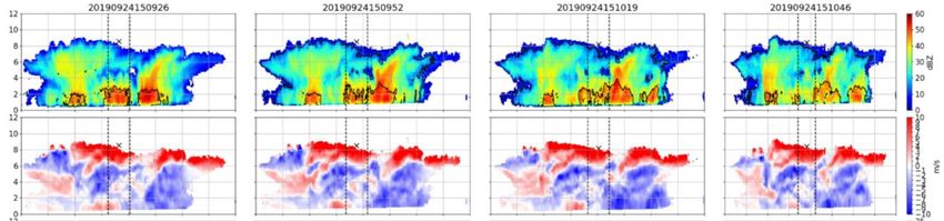
Using 100 m grid-spacing models to
                         represent convection
      1.5 km                    300 m                      100 m

                         Unified Model RA2M

    • Need to understand reason for spurious rain:
        • Too strong vertical velocity? Mixing length impacts?
        • Microphysics issues?
        • Etc?

    • Location of convergence lines agrees well but no rain in reality.
                                                                          © Crown Copyright 2021, Met Office

Kirsty Hanley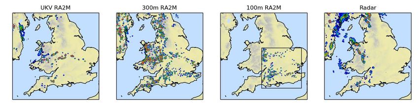
Showers are Too Intense, Too small

Radar                           UM, 1.5 km

                                                                 00UTC

          14UTC 27th Aug 2015, T+10

• Focused, largely circular cells of often too intense rain
• “Greyzone” problem
• Not enough area of lighter rain – sensitive to microphysics: convective/stratiform?
                                                                                        © Crown Copyright 2021, Met Office
Adrian Lock
WesCon: June-Aug 2023
New Modelling Capability
• Convection permitting models: grid-scale O(100m) to O(1km),
• TKE turbulence scheme
• CASIM double moment interactive microphysics
• ParaCon → CoMORPH scale aware convection
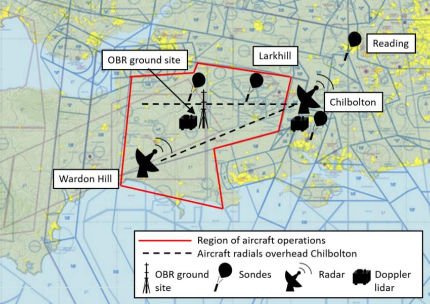
New Radar Capability, Chilbolton, Met Office
•Newly developed techniques: radar measurement of turbulence, thermals, (Feist
2019), (Hogan 2008, Till 2000 inprep)
•X-band upgrade to Chilbolton (early 2022) (~100m resolution at 100km, -20 dBZ
sensitivity)
•Storm cell tracking (after DYMECS (Hogan 2008))
•Met Office Research (off-) network radar at Wardon Hill (S-Band)
Wessex Summertime Convection Experiment
• June → August 2023
• Coordinated Evaluation of 3D cloud and precipitation structures
• In situ airborne observations FAAM BAe146: 80 Hours
• Coincident with radar and ground based observations
© Crown Copyright 2021, Met Office
paul.barrett@metoffice.gov.uk
WesCon 2023: Wessex Summertime
                Convection Experiment

                                    “Wessex”

SkyVector.com
                                                   © Crown Copyright 2021, Met Office

                                                 paul.barrett@metoffice.gov.uk
Aims of WesCon 2023
                 Field campaign
Observe 3D structures of convective clouds and
precipitation over Wessex, during UK summertime

Produce a dataset at high enough resolution and over
sufficient spatial scale to challenge convection permitting
(CP) models with grid-spacing O(100m) and O(1km),
- along with scale aware convection and turbulence
parameterisations.                                            . SkyVectorcom

Target observations towards the pre-convective
environment and the resulting convective, dynamical and
cloud structures and precipitation fields and organisation.
                                                                                 © Crown Copyright 2021, Met Office

                                                                               paul.barrett@metoffice.gov.uk
New Radar Capability
                                                                           60
                                                                               dBz
                                                                           0    +10

                                                                           w [m/s]
                                                                                -10
                                                      Time [+ 30s]
  3D structures of precipitating cloud
  Track storms to build up statistics as in DYMECS
                                                                                      . SkyVectorcom
  Ability to track the aircraft to sample the same clouds
  Particular focus will be on vertical velocity and in-cloud turbulence
  retrievals with aircraft validation.

  Dual wavelength system: New X-band: increased resolution and sensitivity
  Existing S-band system (~500m resolution at 100km, 0 dBZ sensitivity)
  New X-band system available early 2022 (~100m resolution at 100km, -20 dBZ sensitivity)

                                                                                                         © Crown Copyright 2021, Met Office
Scans and graphics by Liam Till.                                                                       paul.barrett@metoffice.gov.uk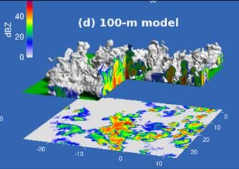
Network Radar Capability
•   Development radar, C-band, D-pol,
    Doppler, at Met Office Wardon Hill
    (Dorset) to observe precipitation
    structures.
       • Bespoke scan strategies. RHI, etc
•   Plus network radars, same specification,
    Dean Hill, Cobbacombe Cross
                                               Network and development radars
                     Wardon Hill RHI, Convective case                           . SkyVectorcom

                                                                                                   © Crown Copyright 2021, Met Office

                                                                                                 paul.barrett@metoffice.gov.uk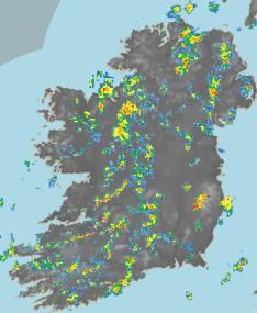
Airborne and Ground Based
Capability
        FAAM aircraft (80 flight hours, ~15 flights,
        ~10 weeks)
        In-situ, dropsondes and remote sensing
        Focus on Wessex, but can access whole UK
        to find convection
                  Ground based observations
                  (June – Aug)
                  Radiosonde facility - mobile
                  Doppler lidar         - mobile
                  Surface flux station with tower - 50m       . SkyVectorcom

                  mast)
                  Microwave radiometer
                  Cloud radar (TBD)

                  Doppler lidar at Chilbolton and
                  Cardington – spatial variability in BL
                  growth and turbulent development

                  Additional radiosondes throughout the
                  region – spatial variability in stability
                  features
                                                                                 © Crown Copyright 2021, Met Office

                                                                               paul.barrett@metoffice.gov.uk
Key Questions
• How does the pre-convective environment influence the
  timing of initiation and subsequent development and
  spatial organisation of convection?
   • Dropsonde, horizontal flight in boundary layer and lower free
     troposphere, radiosonde, Doppler lidar, radars
• What do updraughts and turbulent dynamical structures
  look like at fine spatial scales?
   • In situ aircraft, Chilbolton radar, Doppler lidar               . SkyVectorcom

• How do microphysical properties of convective and
  stratiform cloud features influence the development of
  convection and precipitation?
   • In situ airborne observations, Chilbolton radar

                                                                                        © Crown Copyright 2021, Met Office

                                                                                      paul.barrett@metoffice.gov.uk
WesCon 2023
• Met Office have committed to funding the field
campaign as presented here, June to Aug 2023
• FAAM BAe146, Chilbolton and network Radars, Ground
super-site
• UK Science community workshop April 2022 (this
week) to scope interest for national funding grant
application
Collaborators Encouraged . SkyVectorcom
• We welcome interest from other groups to join the
programme, some ideas:
• Distributed ground observations networks?
• UAVs?
• Additional instrumentation for ground sites?
• Aircraft?
• Modelling studies? Nowcasting? remote sensing? Other?
© Crown Copyright 2021, Met Office
paul.barrett@metoffice.gov.ukYou can also read