Monitoring of Forest Resources Using Low-cost Satellite Images and Cloud Processing Engine - Digitalisaatio työpaja Jyrki Salmi, Senior Partner ...
←
→
Page content transcription
If your browser does not render page correctly, please read the page content below
Monitoring of Forest Resources Using Low-cost Satellite
Images and Cloud Processing Engine
Digitalisaatio työpaja
Jyrki Salmi, Senior Partner, Indufor Oy

7.6.2018
Advances in Approach & Technologies

More EO data:
Since 2015 the number of Earth Observation (EO)                                                Sentinel
satellites has increased significantly. The same location
                                                                                               10 m resolution
can now be imaged multiple times per month. This trend                                         5 day temporal resolution
is expected to continue into 2018 and beyond…               Landsat
                                                            30 m resolution
Cloud Processing Engine
                                                            16 day temporal resolution
Cloud processing platform holds the EO datasets and
allows real-time processing and analysis. Advantage is
that it reduces need to download and pre-process data -
> More time to spend on analysis and developing tools!                                    Sentinel
                                                                                          Radar
Combined these enable continuous or frequent
monitoring of plantation and environmental resources at                                  C-band synthetic aperture radar
affordable cost                                                                          12 day temporal resolution

2      COPYRIGHT © 2018 INDUFOR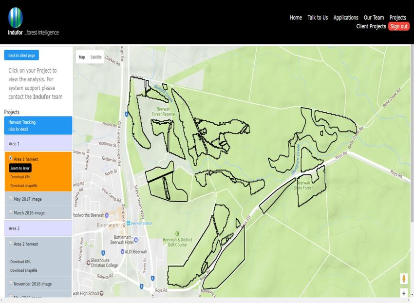
Indufor’s Continuous Plantation Monitoring System (CPMS)

The CPMS is a monitoring tool initially designed
to assist planning managers to more efficiently
allocate field resources.
It uses frequent satellite image observations and
the cloud processing environment.
As an input takes GIS layers and from that builds
a series of models that can be used to provide
routine monitoring.
The CPMS system is designed to provide
analysis ready data that integrates into common
GIS packages.

3      COPYRIGHT © 2018 INDUFOR
Monitoring throughout the rotation

                                            1.   Damage events (fire, wind, snow)
                                            2.   Forest health monitoring
                                            3.   Encroachment monitoring
                                            4.   Monitoring forest operations
                                                 (weeding, thinning, pruning)
    1.   Monitoring of establishment
         success.
    2.   Indexing and mapping plantation
         performance                                 Routine monitoring

                                           Establishment                    Harvest

                                                                                      Progressive forest harvest monitoring
                                                                                      and mapping.

4         COPYRIGHT © 2018 INDUFOR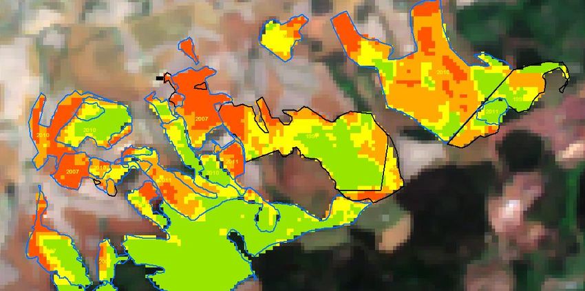
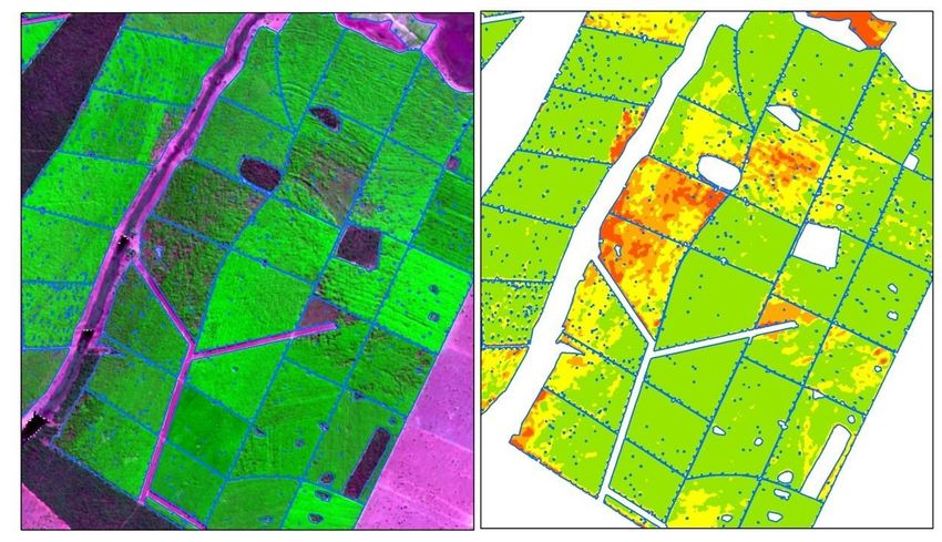
Monitoring Crop Development
What the Canopy Index identifies?

The Canopy Index model is a way to benchmark
plantation development and detect change.
The routine produces a colour-coded index
which is divided into four classes. The index
ranges from green to red. Red values represent
the lowest index values.
Used to Monitor Crop Development
•   Identification of failed areas
•   Stratification of areas development
•   Canopy health

The example tracks a fast growing eucalypt
stand for 8 month period.

5       COPYRIGHT © 2018 INDUFOR
Forest Harvest Updates

The harvest detection routine uses multiple
images.

Running at a pixel level to detect
harvesting and map its extent.

The example shows the progression so
you can work out % completion.

The results are checked, clipped to
boundaries and attributed in a consistent
manner to allow easy integration into
existing GIS systems.

6      COPYRIGHT © 2018 INDUFOR
Delivery Platform
Data Viewer and Access

All data is stored securely on our web portal
and is managed by Indufor. We provide our
clients with:
•   Individual accounts for secure data
    access.
•   An interactive web viewer to visualise and
    query data without the need of an external
    GIS platform.
•   Analysis ready data, provided in familiar
    GIS formats to seamlessly integrate with
    (your) existing systems.
•   Associated satellite images supporting
    each change or detection.
    User: sample.data@indufor-ap.com
    Password: indufor2017

7       COPYRIGHT © 2018 INDUFOR
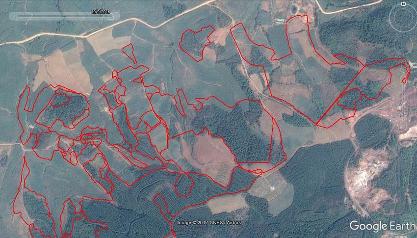
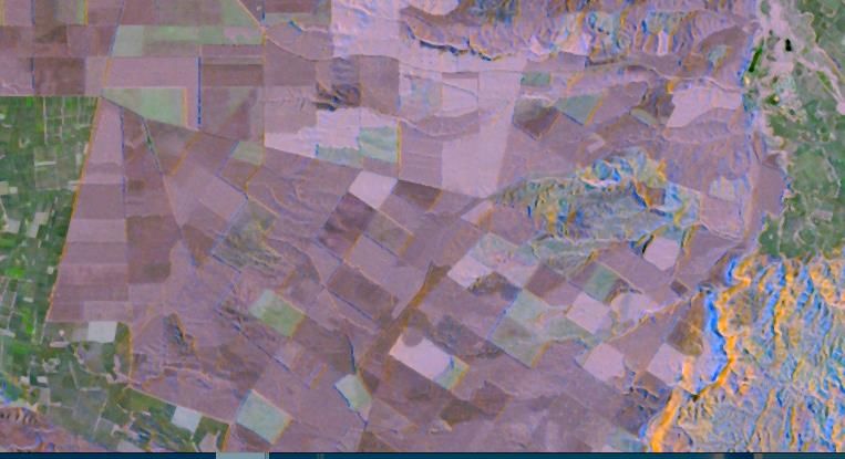
Example: Forest Encroachment

                                      In this example forest plantations are being
                                      progressively encroached. The plantation
                                      areas are near to the public roads and
                                      converted to cropland.

    Google Earth Image – 2016-10-09

                                        Indufor Canopy Index – 2016-12-02

8       COPYRIGHT © 2018 INDUFOR
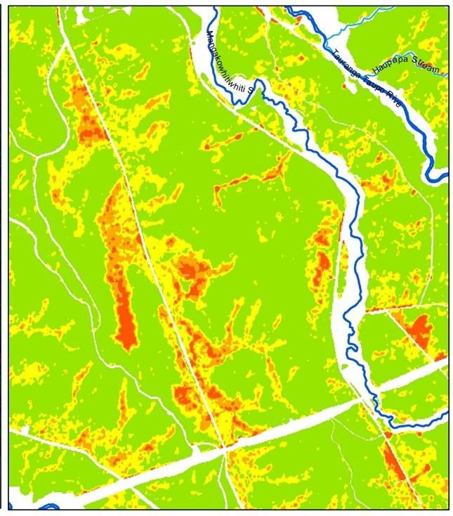
Example: Routine Plantation Monitoring

            Needle blight          Wind damage

    COPYRIGHT © 2018 INDUFOR
9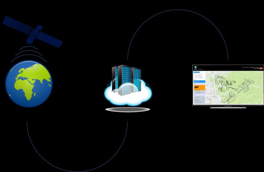
Example: Monthly Monitoring of Fire

                                                       May 2017
Detection and mapping of plantation fires
                                                       Fire disturbance
between two months. Each month the algorithm
is run to identify new losses. These are mapped
and added to the GIS.

                                                       July 2017

10     COPYRIGHT © 2018 INDUFOR                   10
Indufor Oy Indufor Asia Pacific Ltd Indufor Asia Pacific (Australia) Ltd Indufor North America LLC
Esterinportti 2 7th Floor, 55 Shortland St PO Box 425 1875 Connecticut Avenue, NW
FI-00240 Helsinki PO Box 105 039 Flinders Lane, Melbourne VIC 8009 10th floor
AUSTRALIA Washington, DC 20009 USA
FINLAND Auckland City 1143 www.indufor-ap.com www.indufor-na.com
Tel. +358 50 331 8217 NEW ZEALAND
Fax +358 9 135 2552 Tel. +64 9 281 4750
indufor@indufor.fi Fax +64 9 281 4789
www.indufor.fi www.indufor-ap.comYou can also read