Radiometric validation of Sentinel-2AB by prototype WATERHYPERNET deployments in the North Sea
←
→
Page content transcription
If your browser does not render page correctly, please read the page content below
SV2T, 2021-03-17

Radiometric validation of Sentinel-2AB by prototype
WATERHYPERNET deployments in the North Sea
                 and Adriatic Sea

                                   by Kevin Ruddick1,
Quinten Vanhellemont 1, Dieter Vansteenwegen2, Matthew Beck1, Vittorio Brando3, André
                   Cattrijsse2 ,Javier Concha3, Clémence Goyens1

                   1. Royal Belgian Institute for Natural Sciences (RBINS), Belgium
                             2. Flanders Marine Institute (VLIZ), Belgium
                              3. Consiglio Nazionale delle Ricerche, Italy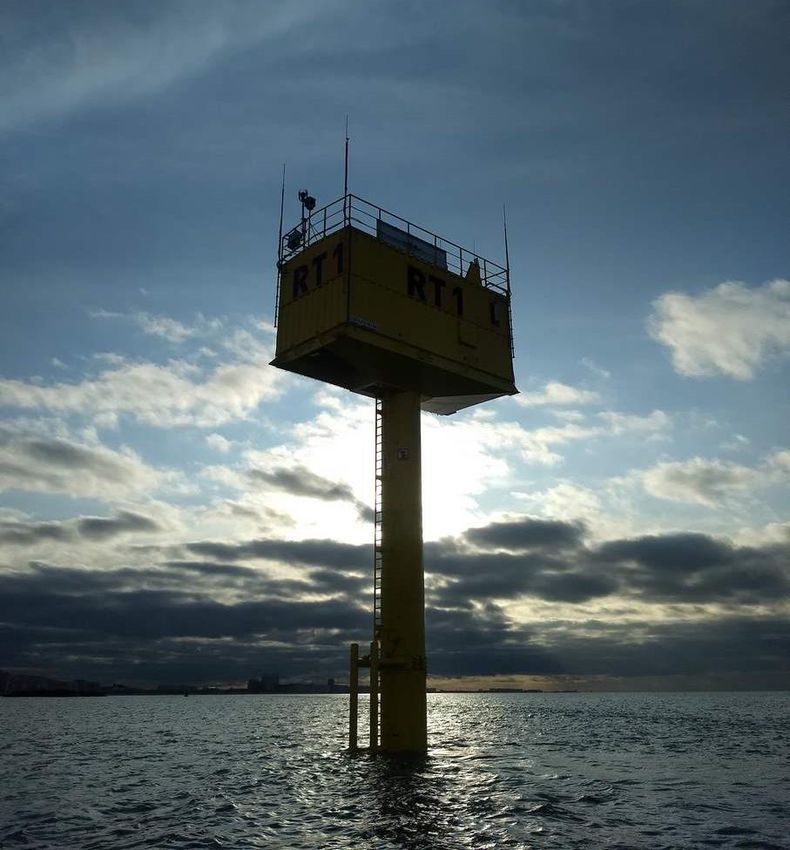
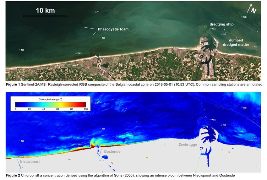
Intense near-shore bloom observed by Sentinel-2A/MSI in Belgian waters
 (red-edge Chl-a absorption – see Vanhellemont & Ruddick 2017)

               Sentinel-2 sees many new processes
        e.g. for EU Water Framework Directive monitoring

        But the quality and usability of all these products
        depends on "level 2" water reflectance validation

Chlorophyll a (µg/l)

0                 100
WATERHYPERNET measurement systems
Existing TRIOS radiometer (2000)                New radiometer (2020-22)
New "PANTHYR" system (2018)
                                                New system (2020-22)
                                              Multiplexed multi-head foreoptics
                                              (radiance, irradiance, optional polarized
                                              radiance, etc) + Camera
                                                                 Fiber optic
                                                                 multiplexer
                                               < WATERHYPERNET
                                                            GPS,
                                                            inclinometer,
                                               equipment #1 etc.

                                                                         Calibration
                                             Radiometer                  monitoring LED
                                                                         + camera

[D. Vansteenwegen et al, "The pan-and-tilt       Pan & Tilt
hyperspectral radiometer system (PANTHYR) for
autonomous satellite validation measurements –
prototype design and testing", Remote Sensing, [H2020/HYPERNETS consortium: RBINS,
2009]                                          TARTU, LOV, GFZ, CNR, NPL, CONICET]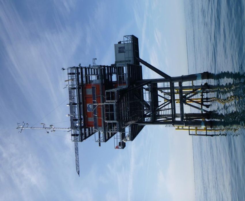
WATER reflectance acquisition protocol

      PARK     3*Ed         3*Ld      11*Lu            3*Ld   3*Ed         PARK
                Ed
                      Ld                        Ld             Ed
                           40°                       40°

 E
40°
      L
                                                                     40°
       20°                           Lu   40°                              20°

side view
 g                                     QC
                                 temporal stability

                    PANTHYR geometry
 (E=irradiance and L=radiance fixed by metal bracket at 40°)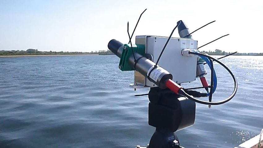
PANTHYR in action
SV2T, 2021-03-17
WATERHYPERNET/PANTHYR Site 1/3
Aqua Alta since 2019-09-25 (still running) with CNR collaboration
CNR site manager
Moderately turbid waters
PRISMA image 2020-02-08
[C.Giardino]
• Robust 18-months functioning
• 1st maintenance visit after 13 months
(radiometer swap)
• Used for validation of S2, S3, L8, Doves,
PRISMA (so far)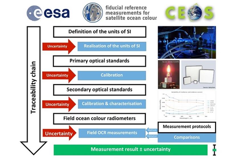
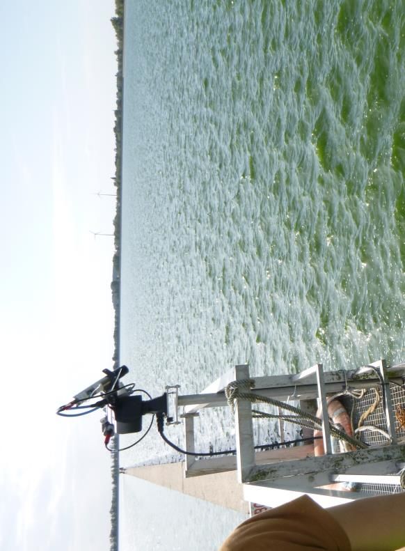
WATERHYPERNET/PANTHYR Site 2/3
Blue Accelerator Platform outside Oostende harbour (2019-11-14 to
2020-08 = 9 months)
– VLIZ/POM collaboration for installation and operation
– Turbid, tidal, eutrophic, port outflow
Planetscope 2020-05-05 10:31UTC
• Robust 9-months functioning
• Used for validation of S2, S3, L8, Doves
• Awaiting redeployment
1km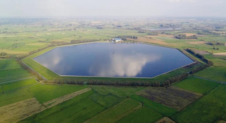
WATERHYPERNET/PANTHYR Site 3/3
Blankaart drinking water reservoir
– De Watergroep site manager
– Very strong adjacency effects => useful target for atmospheric correction
– Short deployments in 2019, longer deployment end-May 2020 w camera
– Cannot yet deploy in reservoir centre - pending construction of safety rail
Maintenance visit 2020-08 (3 months)
• Water ingress problem ...
• Pending redeployment
~800m diameter, drinking water reservoir
De Watergroep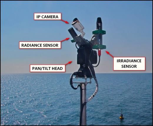
A slide on measurement uncertainties
           [Ruddick et al. "A Review of Protocols for ... Water-
           Leaving Radiance". Remote Sens. 2019, 11, 2198.
           https://doi.org/10.3390/rs11192198]

[Banks et al. "Fiducial Reference Measurements for
Satellite Ocean Colour (FRM4SOC)". Remote Sens. 2020,
12, 1322. https://doi.org/10.3390/rs12081322
and https://frm4soc.org]

         [Ruddick et al. A Review of Protocols for ...
         Downwelling Irradiance. Remote Sens. 2019, 11, 1742.
         https://doi.org/10.3390/rs11151742]
                 (also relevant for land)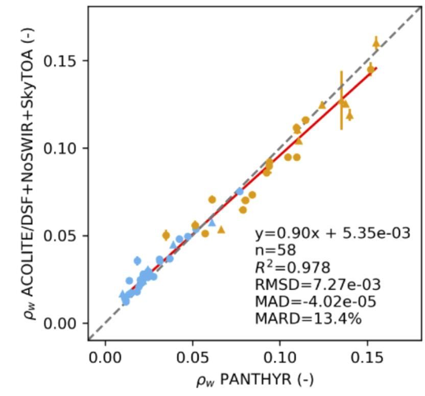
Validation results
S2A/B matchups until 2020-07-15 from Aqua Alta (blue) and
Oostende (orange) WATERHYPERNET sites using new (20210114)
version of ACOLITE/DSF software:
S2/ACOLITE water refl.
443nm 560nm 704nm
In situ water refl. In situ water refl. In situ water refl.
[Vanhellemont Q. Sensitivity analysis of the dark spectrum fitting atmospheric correction for metre- and decametre-
scale satellite imagery using autonomous hyperspectral radiometry (2020) Optics Express, Vol. 28 p397456. DOI:
https://doi.org/10.1364/OE.397456; WATERHYPERNET sites run by VLIZ/POM and CNR]Validation results
S2A/B matchups until 2020-07-15 from Aqua Alta (blue) and
Oostende (orange) WATERHYPERNET sites using new (20210114)
"DSF" version of ACOLITE software:
Results improved when SWIR bands excluded
RMSDifference water refl
S2/ACOLITE - in situ
(30A+28B matchups)
Different A/C variants
[Vanhellemont Q. Sensitivity analysis of the dark spectrum fitting atmospheric correction for metre- and decametre-
scale satellite imagery using autonomous hyperspectral radiometry (2020) Optics Express, Vol. 28 p397456. DOI:
https://doi.org/10.1364/OE.397456; WATERHYPERNET sites run by VLIZ/POM and CNR]CONCLUSIONS WATERHYPERNET network of automatically pointed hyperspectral radiometers is ideal for S2 water reflectance validation: – Many matchups/year for each site (one image => one matchup) – All VIS/NIR bands without "band-shifting" uncertainties – Economy of scale (used also for S3, L8, PlanetDoves, VIIRS, etc. etc.) First 2 WATERHYPERNET sites (Aqua Alta, Oostende) successfully operating for many months: – very robust system design, mature radiometer WATERHYPERNET 2021-22: – Deployment of more systems (target 10 sites in 2022) – Measurement uncertainty analysis (cf. FRM4SOC-2 project) – Exploitation of multi-azimuth and multi-zenith pointing capability Feedback to S2 mission: – ACOLITE/DSF atmospheric correction functioning well – SWIR band calibration needs improvement? – Impact of reference F0 for SWIR?
References
Vanhellemont Q. Sensitivity analysis of the dark spectrum fitting atmospheric
correction for metre- and decametre-scale satellite imagery using autonomous
hyperspectral radiometry (2020) Optics Express, Vol. 28 p397456. DOI:
https://doi.org/10.1364/OE.397456
Vansteenwegen D. & Ruddick K. & Cattrijsse A. & Vanhellemont Q. & Beck M.
The Pan-and-Tilt Hyperspectral Radiometer System (PANTHYR) for Autonomous
Satellite Validation Measurements—Prototype Design and Testing (2019)
Remote Sensing , Vol. 11(11) p. 1360. DOI: https://doi.org/10.3390/rs11111360
WATERHYPERNET/AAOT site run by CNR (V.Brando)
WATERHYPERNET/Oostende site run by VLIZ/POM (D. Vansteenwegen)
S2 ACOLITE atmospheric correction software https://github.com/acolite/acolite
ACOLITE forum: https://odnature.naturalsciences.be/remsem/acolite-forum/
In situ dataset (S2 matchups) available at https://waterhypernet.org/data/
Funded by BELSPO and ESAYou can also read