2014 Sarina Inlet Water Quality Improvement Plan 2014 2021
←
→
Page content transcription
If your browser does not render page correctly, please read the page content below
Water Quality Improvement Plan 2014 - 2021

Sarina Inlet
                                     2014

                                     F T
                 R A                          ]
                                             P1

       D

       Mackay | Whitsunday | Isaac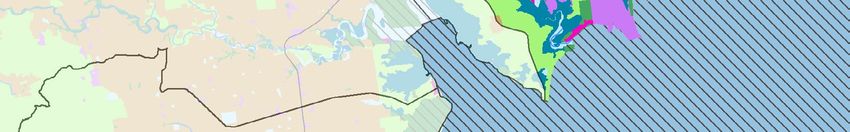
Bakers Creek                                        Sarina Inlet Receiving Waters
                                                                           MAP 1: LANDUSE

       Sandy Creek

                                                                                                         Sarina
                                                                                                        Beaches

                                              Alligator Creek                                                         C A B B A GE T R E E
                                                                                                                                             CR
                                                                                                                                                  E EK

                                                                                                                           I N A IN L E T
                                                                                                                      AR

                                                                                                                  S
                                                                                                              K
                                                                                                         EE
                                                                                                    CR

                                                                                                   AN
                                                                                                   E

P2                                                                                            PL

                                                                      Plane Creek

                                                                     EK
                                                              R CR E
                                                     A   TO
                                              L   IG
                                         AL

                                                                                                                                                         Cape
     Key to land use                                                                                                                                     Creek
        National park or reserve
        Grazing or forestry
        Crop land (cane and horticulture)
                                                                                                              Rocky Dam
        Intensive use (rural residential, transport corridors)
                                                                                                                Creek
        Urban
        Dam or reservoir
        Wetland

        Catchment boundary

        Highway

        Watercourse

        HEV
                                                             Data:
                                                           GBRMPA.
           0       2          4     6         State of Queensland (Department of
                                               Science, Information Technology,
                  Kilometres                     Innovation and the Arts) 2014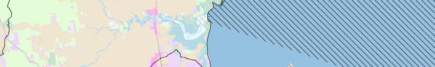
2014 WATER QUALITY IMPROVEMENT PLAN 2014 - 2021
Sarina Inlet 6
[
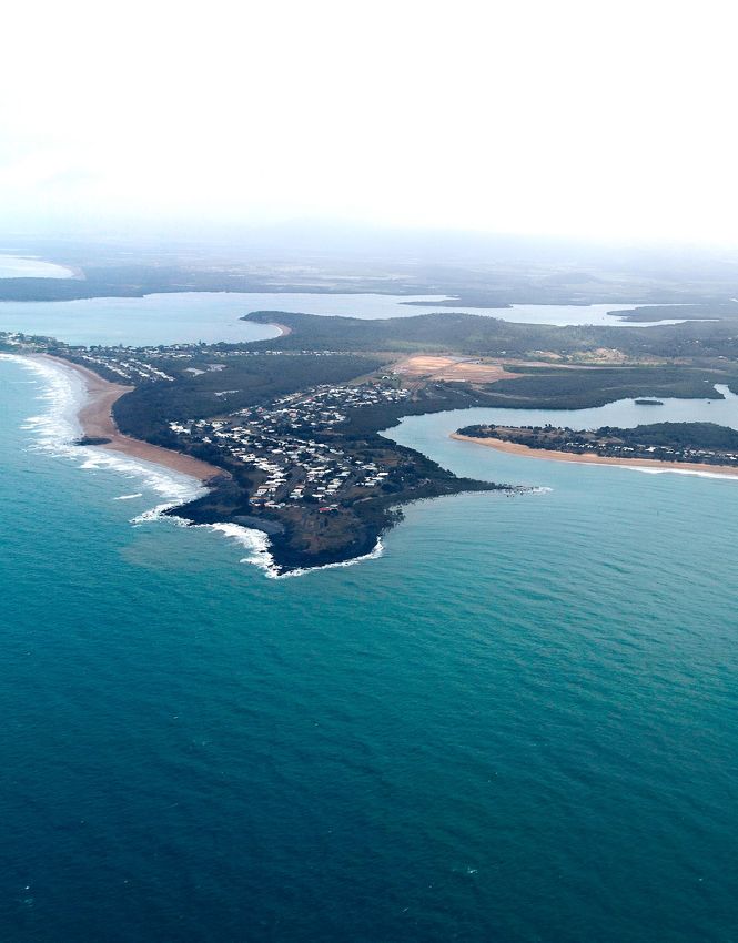
The Sarina Inlet receiving waters stretch from Freshwater Point north to Hay Point. The subcatchments
draining into Sarina Inlet are Sarina Beaches and Plane Creek, which have high proportions of grazing
and sugarcane landuses.
Urban centres within the subcatchments include [ Ecosystem Health Rating
Sarina and Hay Point, and the coastal villages of
Very Good Good Moderate Poor Very Poo r
Sarina Beach, Campwin Beach, and Grasstree
Beach.
The Port of Hay Point in one of the largest coal export VG
[ FRESHWATER
ports in the world. The port is made up of two coal
G Ecosystem Health
terminals, Dalrymple Bay Terminal and Hay Point
Terminal, as well as connecting rail infrastructure. Sarina Inlet freshwater
Other major industrial facilities of the area are Sarina
M ecosystems received an overall
Sugar Mill and Ethanol Distillery. score of Moderate.
VP P
Current Condition Report
Freshwater/ Terrestrial
]
The receiving waters of Sarina Inlet have received
VG
[ MARINE P3
an overall score of Moderate for the condition
G Ecosystem Health
of the connected freshwater ecosystems. Both
subcatchments received scores of Poor for event Sarina Inlet marine ecosystems
water quality, and Good for ambient water quality M received an overall score of
condition. Poor.
VP P
Both Plane Creek and the Sarina Beaches
subcatchments received ecosystem health indicator
scores of Moderate for fish community health and
riparian vegetation. Sarina Beaches received a [ Subcatchments Total Area by Landuse
score of Good for flow, while Plane Creek received
a Moderate. Barriers to fish migration is a particular
issue within both subcatchments (Plane Creek scored
Sugarcane
Very Poor and Sarina Beaches scored Poor), where Production
there are many significant barriers including major
3853 ha
weirs located on Plane Creek.
Horticulture
and Cropping
Marine 94 ha
The receiving waters of Sarina Inlet received an
overall condition score of Poor. Poor event water
quality has resulted in much of the receiving water Grazing and
area of Sarina Inlet being mapped as High risk by the Urban and Forestry
Marine Risk Index. Intensive 14161 ha
Uses
The Sarina Inlet waters contain little coral, however
2460 ha
of the coral that does exist 14% is in High risk. In
contrast, 20% of the region’s seagrass grows in the
Sarina Inlet, and all of it is located in areas that have
a High to Very High risk from water quality. National Parks
Wetlands and
and Reserves
Waterways
1613 ha
2249 ha
Total hectares Sarina Inlet Receiving Waters
24430 ha
Mackay City

                                                             Sarina Inlet Receiving Waters
                                                             MAP 2: MARINE RISK INDEX AND ECOLOGICAL CONDITION
        Bakers Creek

                                   Sandy
                                   Creek                                                                           Sarina
                                                                                                                  Beaches

                                                                   Alligator
                                                                    Creek                                                C A B BA GE T R E E
                                                                                                                                               C RE
                                                                                                                                                      EK

                                                                                                          Plane
                                                                                                          Creek
                                                                                                                             I N A IN L E T
                                                                                                                        AR
P4
                                                                                                                    S

                                                                                                      K
                                                                                                 EE
                                                                                            CR

                                                                                           AN
                                                                                           E

                                                                                      PL

                                                                  C RE E K
                                                             OR
                                                        AT
                                                  LIG
                                             AL

                                                                                                                                                           Cape
                                                                                                                                                           Creek
         Catchment boundary     Marine Risk Index                 Wetland Hazard

         Highway                      Very Low                         Very low

         Fish barrier                 Low                              Low

                                      Moderate                         Moderate
     Ground cover (riparian)
                                                                                                                     Rocky Dam
         Non-riparian forest          High                             High
                                                                                                                       Creek
         Riparian forest              Very High                        Very high
                                                        Data:
                                                      GBRMPA.
           0       2       4      6      State of Queensland (Department of
                                          Science, Information Technology,
                   Kilometres               Innovation and the Arts) 2014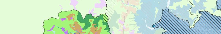
[
               Ecosystem HEALTH

                         Table 1: OVERVIEW

                      This index presents the indicators chosen to assess the condition of freshwater ecosystem health.
                      The index uses a combination of monitored data and expert opinion to provide a score for the
                      current condition of fish community health, event water quality, ambient water quality, flow,
                      riparian vegetation, and barriers to migration for each of the region’s 33 catchment management
                      areas. The table also presents the target for each indicator to be reached by 2021.

                              Subcatchment Freshwater Ecosystem Health
               Table 1
                         [    Indicator Score: Current Condition 2014 and Target 2021

                     Fish Community             Event Water       Ambient                                 Riparian          Barriers to
                          Health                  Quality        Water Quality          Flow             Vegetation         Migration

                         Current Target         Current Target   Current Target   Current Target        Current Target    Current Target

                                                                                                                                              ]
                          2014 2021             2014 2021        2014 2021         2014 2021            2014 2021         2014 2021

 [ Sarina Beaches            M     M             P        M       G        G       G           G          M       M         P         P      P5

     [ Plane Creek           M     M             P        M       G        G       M           M          M       M        VP        VP

                                                                 Very Good        Good             Moderate        Poor         Very Poo r

                         Table 2: OVERVIEW
                         This table displays the total area (as a percentage) of wetlands, coral, and seagrass that exist
                         within each risk category. The risk categories represent the presence of land-based pollutants of
                         greatest risk, ranging from Very Low Risk to Very High Risk.

               Table 2
                         [ Marine Risk and Wetland Hazard
                             Very High                    High               Moderate                  Low                Very Low

[ Wetlands %                              0%                     0%                     6%                     94%                     0%

[ Coral %                                 0%                     14%                    35%                    45%                     7%

[ Seagrass %                              17%                    83%                    0%                      0%                     0%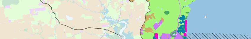
Sarina Inlet Receiving Waters

                    Bakers                        MAP 3: BLUE MAP (HYDROLOGICAL CONNECTIVITY)
                    Creek

     Sandy Creek

                                                                                                    Sarina
                                                                                                   Beaches

                                                                                                           C A B B A GE T R E E
                                                                                                                                  CR
                                                       Alligator                                                                       EE K

                                                            Creek
                                                                                               Plane
                                                                                               Creek            IN A IN L E T
                                                                                                           AR

                                                                                                       S

P6
                                                                                           K
                                                                                      EE
                                                                                 CR
                                                                                E

                                                                                AN
                                                                           PL

                                                                  EK
                                                           R CR E
                                                  A   TO
                                           L   IG
                                      AL

                                                                                                                                              Cape
                                                                                                                                              Creek

                                                                                                            Rocky Dam
                                                                                                              Creek
         Catchment boundary       Water connectivity

         Highway                      Infrequently connected

         Seagrass                     Intermittently connected

         Reef                         Frequently connected

                                      Very frequently connected
                                                     Data:
                                                   GBRMPA.
     0          2       4     6       State of Queensland (Department of
                                       Science, Information Technology,
                Kilometres               Innovation and the Arts) 2014
[ Key Area Targets (corresponding with Blue Map)
The hydrological connectivity shown on the Blue Map is used to prioritise activities for best
ecosystem outcomes. The below details the target activities for areas of differing levels of
connectivity.

    Infrequently Connected areas

•      Target grazing (5414 ha)
•      Target grazing in forests (3147 ha)
•      Target rainforests (663 ha)
•      Target rural residential (588 ha)
•      Target irrigated sugar (637 ha)

    Intermittently Connected areas

•      Target grazing in forests (929 ha)
•      Target grazing (3249 ha)
•      Target irrigated sugar (3120 ha)
•      Target intensive uses (1278 ha)

                                                                                                 ]
    Frequently Connected areas
                                                                                                P7
To improve ecological processes in frequently connected areas:
•    Target 135 ha grazing
•    Target 49 ha ponded pastures
•    Target 48 ha irrigated sugar
•    Target grazing in forests (55 ha) and rainforests (39 ha)

    Very Frequently Connected areas

•      Target 247 ha ponded pastures
2014                        WATER QUALITY IMPROVEMENT PLAN

MAP DATA SOURCES PROVIDED BY:
                                                                      2014 - 2021

STATE OF QUEENSLAND (DEPARTMENT OF SCIENCE,
INFORMATION TECHNOLOGY, INNOVATION AND
THE ARTS) 2014, GREAT BARRIER PARK MARINE
AUTHORITY, MACKAY REGIONAL COUNCIL, ISAAC
REGIONAL COUNCIL AND WHITSUNDAY REGIONAL
COUNCIL.

At the time of publication, all due care and diligence has been
taken to accurately reflect current and collated information.
Research and materials produced by, or for, Reef Catchments
remain the property of Reef Catchments where applicable.
The content of this report is provided for information purposes
only and has been published in good faith. Reef Catchments
does not accept any responsibility for the accuracy or currency
of information, errors or omissions within this report and will
not be liable for any loss, damage, cost or expense incurred or
arising by reason of any person using or relying on information
in this publication.

 REEF CATCHMENTS (MACKAY WHITSUNDAY ISAAC) LIMITED
 PHONE (07) 4968 4200
 EMAIL   reception@reefcatchments.com
                                                                  [
 WEB     www.reefcatchments.com.au

 reefcatchments.com.au/wqip
 ©Reef Catchments (Mackay Whitsunday Isaac) Limited

You can also read