Wetlands Inventory for
the George Washington Memorial Parkway
←
→
Page content transcription
If your browser does not render page correctly, please read the page content below
Wetlands Inventory for the George Washington Memorial Parkway
U.S. Fish and Wildlife Service
National Wetlands Inventory Report

          December 2000
This report should be cited as:

Tiner, R.W., G.S. Smith, and M. Starr. 2000. Wetlands Inventory for the George Washington
Memorial Parkway. U.S. Fish and Wildlife Service, Ecological Services, Northeast Region,
Hadley, MA. National Wetlands Inventory Report. Prepared for the National Park Service.
26 pp.
Wetlands Inventory for the George Washington Memorial Parkway

                                 by
                R.W. Tiner, G.S. Smith, and M. Starr

                   U.S. Fish and Wildlife Service
                         Ecological Services
                National Wetlands Inventory Program
                          Northeast Region
                         Hadley, MA 01035

Prepared for the National Park Service, U.S. Department of the Interior

                           December 2000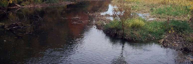
Introduction

The U.S. Fish and Wildlife Service is the lead federal agency for mapping wetlands in the United
States. The Service’s National Wetlands Inventory Program (NWI) has been mapping wetlands
since 1977 and to date, has completed maps for 90 percent of the coterminous United States and
35 percent of Alaska. Maps have been digitized for 45 percent of the lower 48 states and 16
percent of Alaska. In 1996, the NWI initiated an updated mapping project for the George
Washington Memorial Parkway with funds from the National Park Service. The inventory was
completed in 1998. This report summarizes the findings of this inventory project.

Study Area

The George Washington Memorial Parkway is located in Fairfax County, Virginia in the vicinity
of Washington, D.C. It extends from Great Falls National Park along the Potomac River (just
south of the Aqueduct Dam) to Mount Vernon. The Potomac River is tidal from its mouth at
Chesapeake Bay to the “head-of-tides” in the vicinity of the Chain Bridge (Glenn 1988). The
Memorial Parkway includes Theodore Roosevelt Island (between the Key Bridge and Memorial
Bridge) and Dyke Marsh (between Belle View Boulevard and Alexandria Avenue). The
Parkway is located on seven 1:24,000 U.S. Geological Survey topographic maps: Rockville,
Seneca, Vienna, Falls Church, Washington West, Alexandria, and Mount Vernon. Figure 1
shows the general location of the Parkway in the Washington, D.C. area.

                                               1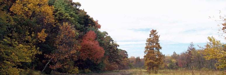
Figure 1. George Washington Memorial Parkway and vicinity locus map.

                                            2
Methods

The NWI relies on conventional aerial photointerpretation techniques to identify, classify, and
delineate wetlands. The original NWI maps produced for the study area were based on early
1980s 1:58,000 color infrared aerial photography. These maps were updated for this project
through photointerpretation of 1994 1:40,000 color infrared aerial photography. With this
imagery, a target minimum mapping unit of 1 acre was established. Smaller wetlands were also
identified where they were conspicuous features (e.g., ponds). Wetlands were initially classified
according to the Service’s official wetlands classification system (Cowardin et al. 1979) which is
the federal standard for reporting on wetland status and trends. Interpretation was reviewed by
staff at the Service’s National Wetlands Inventory Center for national consistency and quality
assurance. Draft maps were produced and distributed to the National Park Service for review
and comment. Field review of draft maps was performed from November 24-25, 1997. Final
maps were published and the maps were digitized for geographic information system (GIS)
processing. The digital wetland database was then used to produce summary statistics for this
report. In addition, this database was expanded to include information on hydrogeomorphic
features of wetlands (i.e., landscape position, landform, and water flow path) according to Tiner
(2000) and information on potential wetland restoration sites.

Collateral data sources that aiding in the wetlands inventory included U.S. Geological Survey
topographic maps and a Virginia Natural Heritage Program report on groundwater invertebrates
(Hobson 1997). The latter was used to locate small seepage wetlands that were vital for rare
invertebrates. These areas were mapped as dot-sized wetlands on the NWI maps.

To evaluate potential wetland restoration on the Parkway property, we assembled historic maps
from the National Archives (College Park, MD). We digitized pertinent information to create a
time series of wetland changes in the Washington, D.C. area. The data were used to show the
location of former wetlands to aid in photointerpreting sites that today may be suitable for
wetland restoration.

                                                3
Results

Wetland Plant Communities

Although the purpose of this work was not to produce a description of the plant communities for
the variety of wetlands on Parkway lands, we did collect some information for a few sites. These
sites were palustrine wetlands. The results are summarized in Table 1 (see Table 3 for common
names).

The largest wetland complex within the Parkway property is the Dyke Marsh in Alexandria.
Several reports have been written about this marsh (Uhler 1963; Thomas 1974, 1976; Haug
1991; Xu 1991; Lindholm 1992; Van Alstine et al. 1992; Kelso et al. 1993; Virginia Department
of Conservation and Recreation 1994). In particular, Thomas (1976) listed seven wetland
communities: Nuphar Zone, Nuphar-Peltandra Mixture, Peltandra Zone, Acorus Zone, Typha
Zone, Swamp Zone, and Flood Plain Zone. The first three zones represent Riverine tidal
emergent wetlands (nonpersistent) regularly flooded. The remaining zones are palustrine
wetlands. The Acorus and Typha Zones are palustrine emergent wetlands, wheres the Swamp
and the Flood Plain Zones are palustrine forested wetlands (seasonally flooded-tidal and
temporarily flooded-tidal, respectively). Table 2 summarizes the vegetation in six of these
zones. Figures 2 and 3 show examples of wetland communities on Parkway lands.

Over 140 plant species have been observed in the Parkway’s wetlands: 24 trees, 21 shrubs, 84
herbs, and 14 vines (Table 3). Nearly 80 species were observed during the two-day field trip in
November.

                                               4
Table 1. Examples of palustrine wetland plant communities within the George Washington
Memorial Parkway (including Great Falls National Park). See Table 2 for Dyke Marsh
examples.
Wetland Type Dominant Species Associated Plants
(Mapping Code)
Palustrine Forested Wetland Acer rubrum Common: Leucothoe racemosa, Vaccinium
broad-leaved deciduous, corymbosum, Cinna arundinacea, Boehmeria
seasonally flooded/saturated cylindrica, Nyssa sylvatica, Symplocarpus foetidus
(PFO1E) Less Common: Osmunda regalis, Osmunda cinnamomea,
Rhododendron viscosum, Viburnum dentatum,
Smilax rotundifolia, Lindera benzoin
Fraxinus pennsylvanica/ Common: Lindera benzoin, Smilax rotundifolia,
Acer rubrum Impatiens capensis, Betula nigra, Platanus
occidentalis
Less Common: Quercus phellos, Lonicera japonica,
Carpinus caroliniana, Leersia oryzoides, Vitis sp.,
Viburnum prunifolium
Palustrine Forested Wetland Liriodendron tulipifera Common: Fraxinus pennsylvanica, Acer rubrum,
broad-leaved deciduous, Toxicodendron radicans, Carpinus caroliniana,
seasonally flooded Boehmeria cylindrica, Geum sp., Lindera benzoin,
(PFO1C) Carex sp., Lonicera japonica
Less Common: Viburnum prunifolium, Rubus
flagellaris, Osmunda cinnamomea, Viburnum
dentatum, Dryopteris cristata, Ligustrum sp., Cinna
arundinacea, Smilax rotundifolia, Osmunda regalis,
Arisaema triphyllum, Solidago sp., Symplocarpus
foetidus, Berberis thunbergii, Polystichum
acrostichoides, Parthenocissus quinquefolia, Vitis sp.,
Ilex verticillata
Palustrine Forested Wetland Liriodendron tulipifera/ Common: Lindera benzoin, Asimina triloba,
broad-leaved deciduous, Fraxinus pennsylvanica/ Viburnum dentatum, Thelypteris novaboracensis
temporarily flooded Acer rubrum Less Common: Dryopteris cristata, Platanus
(PFO1A) occidentalis, Smilax rotundifolia, Prunus serotina,
Lonicera japonica, Toxicodendron radicans, Allium
vineale, Ilex opaca
Platanus occidentalis Common: Fraxinus pennsylvanica, Lindera benzoin,
Lonicera japonica
Less Common: Ilex opaca, Ulmus sp., Smilax
rotundifolia, Rosa multiflora
Palustrine Forested Wetland Fraxinus pennsylvanica Common: Cornus amomum, Acer negundo
broad-leaved deciduous Less Common: Ulmus sp., Salix nigra, Sambucus
seasonally flooded-tidal canadensis, Toxicodendron radicans, Acer
(PFO1R) saccharinum, Viburnum dentatum, Lysimachia
ciliata, Lonicera sp.
5Fraxinus pennsylvanica Common: Polygonum punctatum, Cornus amomum,
Boehmeria cylindrica, Rosa multiflora, Mikania
scandens, Alnus serrulata, Carex sp., Liquidambar
styraciflua
Less Common: Bidens sp., Parthenocissus
quinquefolia, Sambucus canadensis, Acer rubrum,
Salix nigra, Platanus occidentalis, Juncus effusus,
Vitis sp., Rosa palustris, Onoclea sensibilis
Fraxinus pennsylvanica/ Common: Ilex verticillata, Boehmeria cylindrica,
Liquidambar styraciflua Toxicodendron radicans
Less Common: Viburnum dentatum, Sambucus
canadensis, Lonicera japonica, Aster sp.,
Polygonum arifolium, Viola sp., Osmunda regalis,
Lycopus sp., Campsis radicans, Onoclea sensibilis,
Rhododendron viscosum, Alnus serrulata, Smilax
rotundifolia
Acer rubrum/Salix nigra/ Common: Polygonum arifolium, Cinna arundinacea,
Fraxinus pennsylvanica Iris pseudacorus, Leersia oryzoides, Peltandra
virginica
Less Common: Taxodium distichum, Alisma sp.,
Hibiscus moscheutos, Cicuta maculata, Lonicera
japonica, Bidens sp., Clematis sp., Solidago sp.,
Toxicodendron radicans, Chelone glabra, Aster
vimineus, Elymus virginicus, Campsis radicans, Vitis
sp.
Palustrine Forested Wetland Acer negundo/Acer Common: Lindera benzoin
broad-leaved deciduous, saccharinum Less Common: Fraxinus pennsylvanica, unidentified
temporarily flooded-tidal shrub (incomplete listing)
(PFO1S)
Palustrine Emergent Wetland Polygonum sagittatum Less Common: Rubus sp., Bidens sp.,
persistent, seasonally flooded, Ampelopsis brevipedunculata
ditched (PEM1Cd)
Palustrine Emergent Wetland Typha angustifolia Common: Phalaris arundinacea, Polygonum
persistent, seasonally flooded-tidal sagittatum
(PEM1R) Less Common: Scirpus fluviatilis, Polygonum sp.,
Iris pseudacorus, Bidens connata/laevis?, Hibiscus
moscheutos, unidentified Asteracea, Solidago sp.,
Carex sp., unidentified grass, Aster simplex?,
Taxodium distichum, Peltandra virginica,
Liquidambar styraciflua, Salix nigra
Table 2. Wetland plant communities of Dyke Marsh based on observations of Thomas (1976).
Wetland type is likely type according to Cowardin et al. (1979) with NWI map code.
6Community Dominant Plants Associated Species
(Wetland Type)
Nuphar Zone Nuphar luteum Pontederia cordata
(Riverine emergent wetland,
nonpersistent, regularly flooded;
R1EM2N)
Peltandra Zone Peltandra virginica and Zizania aquatica, Amaranthus (Acnida)
(Riverine emergent wetland, Polygonum punctatum cannabinus, Echinochloa walterii, Cyperus
nonpersistent, regularly flooded; erythrorhizos, Cyperus odoratus, Iris pseudacorus,
R1EM2N) Aneilema keisak, Polygonum arifolium, Polygonum
sagittatum, Rorippa islandica, Vernonia sp., Bidens
laevis
Acorus Zone Acorus calamus Leersia oryzoides, Scirpus pungens (americanus),
(Palustrine emergent wetland, Scirpus fluviatilis, Hibiscus moscheutos, Sagittaria
persistent, regularly flooded; latifolia, Helenium autumnale, Amaranthus (Acnida)
PEM1R) cannabinus
Typha Zone Typha angustifolia Impatiens capensis, Rosa palustris, Cephalanthus
(Palustrine emergent wetland, occidentalis, Hibiscus moscheutos, Amaranthus
persistent, regularly flooded; (Acnida) cannabinus, Typha latifolia
PEM1R)
Swamp Zone Fraxinus tomentosa, Lindera benzoin, Viburnum dentatum,
(Palustrine forested wetland, Fraxinus pennsylvanica, Sambucus canadensis, Cornus amomum,
broad-leaved deciduous, and Salix nigra Saururus cernuus, Chionanthus virginicus, Iris
seasonally flooded-tidal; versicolor, Apios americana, Mikania scandens,
PFO1R) Amorpha fruitcosa, Ilex verticillata, Viburnum
nudum, Nyssa sylvatica, Gentiana sp.
Flood Plain Zone None listed Lysimachia ciliata, Calystegia (Convolvulus)
(Palustrine forested wetland, sepium, Cuscuta sp., Sicyos angulatus, Actinomeris
broad-leaved deciduous, alternifolia, Ampelopsis brevipedunculata, Ulmus
temporarily flooded; PFO1A) americana, Morus alba, Populus deltoides,
Liquidambar styraciflua, Lonicera japonica,
Toxicodendron (Rhus) radicans, Prunus serotina,
Viburnum recognitum, Quercus phellos, Sassafras
albidum, Acer rubrum, Smilax rotundifolia, Acer
saccharinum, Gleditsia triacanthos, Pinus virginiana,
Campsis radicans, Vitis spp., Fagus grandifolia,
Cornus stolonifera
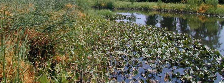
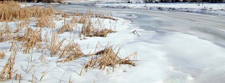
7Figure 2. Emergent wetlands dominated by spatterdock (Nuphar luteum) and narrow-leaved
cattail (Typha angustifolia) in summer (a) and in winter (b).
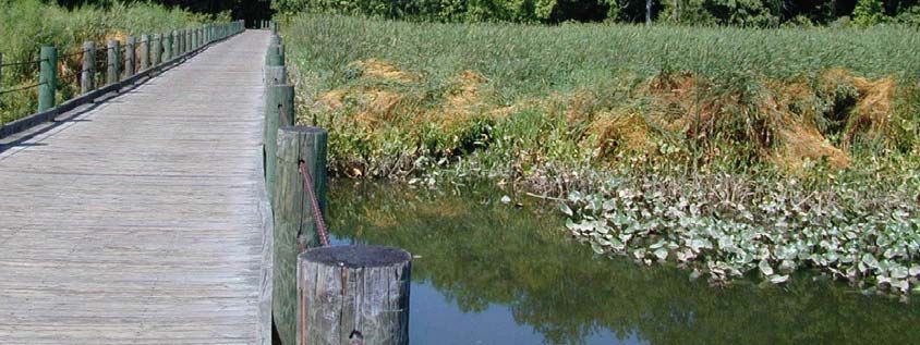
8Figure 3. Wetland along trail at Theodore Roosevelt Island.
9Table 3. List of plants observed in wetlands of the George Washington Memorial Parkway.
Plants are listed alphabetically by scientific name and arranged by life form (tree, shrub, herbaceous plant,
or vine). Species marked by an asterisk (*) were observed by others. Plants reported in flood plain by
Thomas (1976) may or not be associated with wetlands; these are designated by (F). Rare species were
noted as (R); some may be extirpated (Van Alstine et al. 1992).
Life Form Scientific Name Common Name
Tree Acer negundo Box Elder
Acer rubrum Red Maple
Acer saccharinum Silver Maple
Betula nigra River Birch
Carpinus carolinana Ironwood
Chionanthus virginicus* Fringe Tree
Fagus grandifolia*(F) American Beech
Fraxinus pennsylvanica Green Ash
Fraxinus tomentosa* Pumpkin Ash
Gleditsia triacanthos*(F) Black Locust
Ilex opaca American Holly
Liquidambar styraciflua Sweet Gum
Liriodendron tulipifera Tulip or Yellow Poplar
Morus alba*(F) White Mulberry
Nyssa sylvatica* Black Gum
Pinus virginiana* (F) Virginia Pine
Platanus occidentalis Sycamore
Populus deltoides*(F) Eastern Cottonwood
Prunus serotina Black Cherry
Quercus phellos Willow Oak
Salix nigra Black Willow
Taxodium distichum Bald Cypress
Ulmus americana American Elm
Ulmus rubra* Slippery Elm
Shrub Alnus serrulata Smooth Alder
Amorpha fruticosa* False Indigo
Asimina triloba Pawpaw
Berberis thunbergii Japanese Barberry
Cephalanthus occidentalis* Buttonbush
Cornus amomum Silky Dogwood
Cornus stolonifera*(R) Red Osier Dogwood
Ilex verticillata Common Winterberry
Leucothoe racemosa Fetterbush
Ligustrum sp. Privet
Lindera benzoin Spicebush
Rhododendron viscosum Swamp Azalea
Rosa multiflora Multiflora Rose
Rosa palustris Swamp Rose
Rubus sp. Blackberry
Sambucus canadensis Common Elderberry
Vaccinium corymbosum Highbush Blueberry
Viburnum dentatum Southern Arrowwood
Table 3 (cont’d). List of plants observed in wetlands of the George Washington Memorial Parkway.
10Viburnum nudum* Southern Wild Raisin
Viburnum prunifolium Black Haw
Viburnum recognitum*(F) Northern Arrowwood
Herb Acorus calamus* Sweet Flag
Actinomeris alternifolia*(F) Wingstem
Alisma sp. Water Plantain
Allium vineale Field Garlic
Amaranthus cannabinus* Water Hemp
Aneilema keisak* Asiatic Dayflower
Arisaema triphyllum Jack-in-the-Pulpit
Asclepias incarnata* Swamp Milkweed
Aster simplex? Panicled White Aster
Aster sp. Aster
Aster vimineus Small White Aster
Bidens cernua* Nodding Beggar-ticks
Bidens connata? Swamp Beggar-ticks
Bidens laevis* Bur-marigold
Bidens sp. Beggar-ticks
Boehmeria cylindrica False Nettle
Cabomba caroliniana*(R) Fanwort
Calystegia sepium* Hedge Bindweed
Carex sp. Sedge
Carex crinita Fringed Sedge
Carex decomposita*(R) Epiphytic Sedge
Carex interior*(R) Inland Sedge
Carex lacustris*(R) Lakebank Sedge
Chelone glabra Turtlehead
Cicuta maculata Water Hemlock
Cinna arundinacea Wood Reed
Cyperus aristatus*(R) Awned Flatsedge
Cyperus erythrorhizos* Red-root Flatsedge
Cyperus odoratus* Fragrant Flatsedge
Dryopteris cristata Crested Fern
Echinochloa walterii* Walter Millet
Elymus virginicus Virginia Rye Grass
Eriocaulon parkerii*(R) Parker’s Pipewort
Gentiana sp.* Gentian
Geum allepicum*(R) Yellow Avens
Geum lacinatum*(R) Rough Avens
Geum sp. Avens
Helenium autumnale* Sneezeweed
Hibiscus moscheutos Rose Mallow
Impatiens capensis Jewelweed
Iris pseudacorus Yellow Flag
Iris versicolor*(R) Blue Flag
Juncus effusus Soft Rush
Leersia oryzoides Rice Cutgrass
Leersia virginica* White Grass
Table 3 (cont’d). List of plants observed in wetlands of the George Washington Memorial Parkway.
11Lobelia cardenalis* Cardinal Flower
Lycopus sp. Bugleweed
Lysimachia ciliata Fringed Loosestrife
Hemianthus micranthemoides*(R) Delaware River Mudflower
Nuphar luteum* Spatterdock
Onoclea sensibilis Sensitive Fern
Osmunda cinnamomea Cinnamon Fern
Osmunda regalis Royal Fern
Peltandra virginica Arrow Arum
Phalaris arundinacea Reed Canary Grass
Phragmites australis* Common Reed
Plantago cordata*(R) Heart-leaf Plantain
Polygonum sp. Smartweed
Polygonum arifolium Halberd-leaved Tearthumb
Polygonum punctatum Dotted Smartweed
Polygonum sagittatum Arrow-leaved Tearthumb
Polytrichum acrostichoides Christmas Fern
Pontederia cordata* Pickerelweed
Potamogeton amplifolius*(R) Large-leaf Pondweed
Potamogeton robbinsii*(R) Flat-leaf Pondweed
Potamogeton zosteriformis*(R) Flat-stem Pondweed
Rorippa islandica* Water Cress
Rumex altissimus*(R) Tall Dock
Rumex sp. Dock
Sagittaria latifolia* Broad-leaved Arrowhead
Saururus cernuus* Lizard’s Tail
Scirpus fluviatilis (R) River Bulrush
Scirpus pungens* Common Three-square
Solidago sp. Goldenrod
Sparganium americanum* Eastern Bur-reed
Spiranthes odorata*(R) Fragrant Ladies’-tresses
Symplocarpus foetidus Skunk Cabbage
Thalictrum polygamum* Tall Meadow-rue
Thelypteris novaboracensis New York or Tapering Fern
Typha angustifolia Narrow-leaved Cattail
Typha latifolia* Broad-leaved Cattail
Utricularia macrorhiza*(R) Common Bladderwort
Vernonia sp.* Ironweed
Viola sp. Violet
Xyris caroliniana*(R) Carolina Yellow-eyed Grass
Zizania aquatica* Wild Rice
Vines Ampelopsis brevipedunculata Asiatic Pepper Vine
Apios americana* American Potato Bean
Calystegia sepium* Hedge Bindweed
Campsis radicans Trumpet Creeper
Clematis sp. Clematis
Cuscuta gronovii Dodder
Table 3 (cont’d). List of plants observed in wetlands of the George Washington Memorial Parkway.
Lonicera japonica Japanese Honeysuckle
Mikania scandens Climbing Hempweed
12Parthenocissus quinquefolia Virginia Creeper
Rubus flagellaris Dewberry
Sicyos angulatus*(F) Bur-cucumber
Smilax rotundifolia Common Greenbrier
Toxicodendron radicans Poison Ivy
Vitis sp. Grape
13Wetland Acreage Summary
NWI Types. Based on NWI mapping, the George Washington Memorial Parkway had
approximately 431 acres of wetland, 237 acres of deepwater habitat, and 3,539 acres of upland.
Wetlands, therefore, made up roughly 11 percent of the Parkway lands. The composition of the
wetlands is discussed below. The 200+ acres of deepwater habitat were mostly riverine tidal
waters (131.3 acres) which accounted for 55 percent of this habitat. The rest of the Parkway’s
deepwater habitats consisted of 74.2 acres of lacustrine waters and 32.0 acres of other river
waters. Figure 4 shows wetlands in the Parkway and vicinity, classified according to NWI types.
An acreage summary of the major wetland types according to the U.S. Fish and Wildlife
Service’s classification system is given below. See Appendix for acreage summaries for more
detailed classifications.
Wetland Type Acreage
Palustrine Wetlands
Emergent/Shrub-tidal 6.3
Emergent-nontidal 6.5
Emergent-tidal 130.3
Forested-tidal 159.0
Forested-nontidal 72.2
Shrub-tidal 2.9
Shrub-nontidal 0.3
Unconsolidated Bottom (pond) 2.6
----------------------------------------- -------
Subtotal Palustrine 380.1
Riverine Wetlands
Emergent-tidal 24.3
Unconsolidated Shore-tidal 18.2
Rocky Shore-nontidal 3.2
------------------------------------------ -------
Subtotal Riverine 45.7
Lacustrine Wetlands
Emergent-tidal 2.8
Rocky Shore-nontidal 2.1
-------------------------------------------- -------
Subtotal Lacustrine 4.9
------------------------------------------------------------
GRAND TOTAL - ALL WETLANDS 430.7
------------------------------------------------------------
14Eighty percent of the Parkway’s wetlands are tidal wetlands, with forested wetlands and
emergent wetlands in nearly equal amounts. These two types accounted for 92 percent of the
tidal wetlands. Nontidal wetlands represented just 20 percent of the Parkway’s wetlands.
Overall, forested wetlands predominated, making up about 54 percent of all the wetland acreage,
while emergent wetlands comprise 38 percent.
Nonvegetated wetlands (including ponds) occupied only 26.1 acres. Seventy percent of these
wetlands are tidal flats (riverine unconsolidated shores) along the Potomac River.
15Figure 4. Distribution of wetlands in the George Washington Memorial Parkway and vicinity,
mapped according to NWI types (Cowardin et al. 1979).
16Hydrogeomorphic Types. The Parkway’s wetlands were also classified by landscape position,
landform and water flow path following Tiner (2000). Lentic wetlands are associated with lakes
and reservoirs, lotic wetlands with rivers and streams, and terrene wetlands are isolated or
headwater wetlands (sources of streams). The totals below are for vegetated wetlands, with
ponds being reported separately.
Landscape Position Landform (Water Flow Path) Acreage
Lentic
Basin (Bidirectional-nontidal) 0.3
Floodplain (Bidirectional-nontidal) 5.6
Fringe (Bidirectional-tidal) 10.1
----------------------------------------- ------
Subtotal 16.0
Lotic River
Low Gradient
Floodplain (Throughflow) 24.5
Fringe (Throughflow) 3.2
Island (Throughflow) 0.3
------------------------------------------ ------
Subtotal 28.0
Tidal Gradient
Floodplain 171.9
Fringe 168.7
-------------------------- --------
Subtotal 340.6
Dammed Gradient Floodplain 8.3
Fringe 2.1
Island 0.2
----------------- ------
Subtotal 10.6
Lotic Stream
Low Gradient
Basin 8.7 (=headwater)
Flat 16.8 (14.3 a.=headwater)
---------------- --------
Subtotal 25.5
Terrene
Basin (Isolated) 5.5
Basin (Outflow) 1.0 (=headwater)
Flat (Isolated) 1.0
--------------------- -------
Subtotal 7.5
17The vegetated wetlands were mostly lotic wetlands associated with the Potomac River. Fringe
wetlands are likely to be important fish nursery grounds and waterfowl/waterbird feeding areas.
Floodplain wetlands temporarily store water during high runoff periods (during and after heavy
rains; after snowmelt from higher elevations in the Potomac River watershed in western
Maryland, northern Virginia, and eastern West Virginia). Lotic stream wetlands store water
from local runoff, with basin wetlands holding the water longer than flat wetlands. Terrene
basins also store water from surrounding areas (very localized areas). Headwater wetlands
include wetlands that are sources of streams as well as wetlands along first-order streams. They
should be important for streamflow maintenance. Figure 5 shows the locations of various
wetland types classified by landscape position.
Only 2.6 acres of ponds were classified: 2.2 were isolated (terrene types) and 0.4 were
throughflow (lotic types). The latter represent ponds created by impounding streams.
18Figure 5. Distribution of wetland types of the George Washington Memorial Parkway and
vicinity, classified by landscape position (Tiner 2000).
19Historical Wetland Trends
To determine potential wetland restoration sites on the Parkway grounds, a cursory assessment
of former wetlands in the Washington, D.C. area was performed by reviewing historic maps.
Information from this analysis is shown in Figure 6. Many wetlands and shallow river bottoms
have been filled since the mid-1800s. Note that three prominent Washington landmarks (the
Lincoln Memorial, the Jefferson Memorial, and the White House) were built on former wetlands
or river bottoms. The series of five maps presented as Figure 6 show general trends from 1863
through 1994. Due to differences in survey methods, the boundaries of designated wetlands
should be considered approximate, especially for the years 1863 through 1924.
20Figure 6. General trends in wetlands and Potomac River alterations in the Washington, D.C.
area: a) 1863, b) 1885, c) 1915, d) 1924, and e) 1994. Data for the first four years came from
historic maps on file at the National Archives.
Wetland Restoration Opportunities
21Many wetlands and shallow river bottoms have been filled in the Washington, D.C. area in the
past (Figure 6). Due to their current condition (e.g., permanent structures, including Ronald
Reagan National Airport), opportunities for wetland restoration in the George Washington
Memorial Parkway are extremely limited.
Only two Type 1 potential wetland restoration sites (former wetlands that may be restorable)
were identified (Figure 7). These sites are now upland forests on Daingerfield Island, but
according to historical maps they were once wetlands. The sites are 11 acres and 10 acres in
size. Examination of soil beneath suspected fill at these sites is necessary to confirm their
former wetland condition (presence of buried hydric soils). Four Type 2 potential wetland
restoration sites were identified: three ditched sites (totaling 4.7 acres; Figure 7) and one
impounded site (totaling only 0.7 acres; Figure 8). The ditched wetlands were palustrine
emergent wetland (1.7 acres), palustrine deciduous scrub-shrub wetland (1.7 acres), and
palustrine deciduous forested wetland (1.3 acres). If the hydrology is significantly altered due to
the ditching, one might consider plugging the ditches to restore pre-disturbance hydrology.
Restoration for the impounded wetland would require removing the dikes or at least breaching
the dikes, so that they are more freely connected to local hydrology. An evaluation of the
benefits of restoration at each of these sites must be done to determine whether such efforts
would be worthwhile given changes in the surrounding areas (e.g., current fish and wildlife use
vs. projected usage; potential for increased flood water storage, etc.).
22Figure 7. Location of potential wetland restoration sites at Daingerfield Island. Base map is the
U.S. Geological Survey topographic map for Alexandria.
23Figure 8. Location of impounded former wetland on Bear Island that may be suitable for
restoration. Base map is the U.S. Geological Survey topographic map for Falls Church.
24Acknowledgments
25This project was funded by the National Park Service (NPS). Melissa Kangas from the George
Washington Memorial Parkway served as project officer for the NPS. She also assisted in the
field and provided much background information for use on this project. Her efforts are greatly
appreciated. Ralph Tiner was project officer for the U.S. Fish and Wildlife Service (FWS-
Hadley, MA) and wrote the report.
Photointerpretation was performed by Glenn Smith (FWS-Hadley, MA). The U.S. Fish and
Wildlife Service’s National Wetlands Inventory Center (NWIC) produced draft and final maps
and constructed the digital database. The Northeast Region’s National Wetlands Inventory
Program (Hadley, MA) enhanced the NWI digital data and added information on
hydrogeomorphic wetland properties and potential wetland restoration sites. John Swords
interpreted the latter, while Matt Starr performed the former. Mr. Starr was also responsible for
conducting geospatial analysis of data, for compiling historic data on wetland losses from
historic maps, and for assembling the final digital database. Bobbi Jo McClain assisted by
preparing graphics for the final report and putting the report in a compact disk (CD) format.
Dan Sealy (NPS) and Jo Ann Mills (FWS-Arlington, VA) assisted during field investigations.
The National Archives provided access to historic maps from their files for use in this study.
Photographs of wetlands included in this report were provided by the National Park Service.
26References
Cowardin, L.M., V. Carter, F.C. Golet, and E.T. LaRoe. 1979. Classification of Wetlands and
Deepwater Habitats of the United States. U.S. Fish and Wildlife Service, Washington, D.C.
FWS/OBS 79-31.
Glenn J.L. 1988. Bottom sediments and nutrients in the tidal Potomac system, Maryland and
Virginia. U.S. Geological Survey, Reston, VA. USGS Water-Supply Paper 2234.
Haug, E. 1991. Flora of Dyke Marsh. June-September 1991. Unpublished 10-page manuscript.
Hobson, C.S. 1997. A Natural Heritage Inventory of Groundwater Invertebrates within the
Virginia portions of the George Washington Memorial Parkway including Great Falls Park.
Virginia Department of Conservation and Recreation, Division of Natural Heritage, Richmond,
VA. Natural Heritage Technical Report 97-9.
Thomas, L.K. 1974. A Short Natural History of Dyke Marsh. National Park Service, Center for
Urban Ecology. Unpublished 5-page manuscript.
Thomas, L.K. 1976. General vegetative composition of Dyke Marsh as complied by Dr. L.K.
Thomas. Appendix VII. In: U.S. Department of Interior. Environmental Assessment of Dyke
Marsh, George Washington Memorial Parkway, National Capitol Region, National Park Service.
Tiner, R.W. 2000. Keys to Waterbody Types and Hydrogeomorphic-Type Wetland Descriptors
for U.S. Waters and Wetlands (Operational Draft). U.S. Fish and Wildlife Service, Ecological
Services, Northeast Region, Hadley, MA.
Uhler, F. 1963. Vegetation and animals noted in Dyke Marsh by a team headed by Dr. F. Uhler.
Appendix III. In: U.S. Department of Interior. Environmental Assessment of Dyke Marsh,
George Washington Memorial Parkway, National Capitol Region, National Park Service.
Van Alstine, N.E., K.A. Buhlmann, and A. Belden. 1992. A Natural Heritage Resources
Inventory of Hunting Bay-Dyke Marsh, Alexandria City and Fairfax County, Virginia. Virginia
Department of Conservation and Recreation, Division of Natural Heritage, Richmond, VA.
Natural Heritage Program Technical Report #92-4.
Virginia Department of Conservation and Recreation. 1994. Addendum to A Natural Heritage
Resources Inventory of Hunting Bay-Dyke Marsh, Alexandria City and Fairfax County,
Virginia, Natural Heritage Program Technical Report #92-4. Division of Natural Heritage,
Richmond, VA.
Xu, A. 1991. Final Report of Inventories of Plant Species and Communities in Dyke Marsh,
Alexandria, Virginia. George Mason University.
27You can also read