Wildlife habitat connectivity across the City of Whitehorse - Amy K. Hahs, Estibaliz Palma and Luis Mata
←
→
Page content transcription
If your browser does not render page correctly, please read the page content below
Wildlife habitat connectivity across
the City of Whitehorse
Amy K. Hahs, Estibaliz Palma and Luis Mata
Cover photo by Luis Mata ‘Blue-banded bee at Bushy Creek Reserve, Box Hill North’
This report was finished in Melbourne (Victoria, Australia) on August 6th, 2021.

Please cite as:
Hahs A, Palma E, Mata L. (2021) Wildlife habitat connectivity across the City of Whitehorse. Report prepared for
Whitehorse City council.
Wildlife habitat connectivity across the City of Whitehorse

       Report prepared for Whitehorse City Council
                                    August 2021

                                           by

                                   Amy K. Hahs
                                  Estibaliz Palma
                                     Luis Mata

             School of Ecosystem and Forest Sciences, The University of Melbourne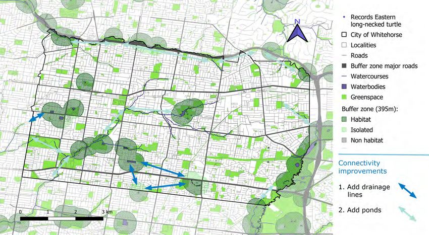
Acknowledgements

The authors would like to acknowledge the Traditional Custodians of the land and waterways on
which the project took place, the Wurundjeri peoples of the Woi Wurrung language group, part of the
greater Eastern Kulin Nations. We pay our respects to Wurundjeri Elders, past, present and emerging.
We honour the deep spiritual, cultural and customary connections of the Traditional Custodians to the
landscape and ecology of the land on which the City of Whitehorse is located.

We are very grateful to the Whitehorse City Council for funding this project.

We would especially like to thank Millie Wells, Belinda Moody, and Ian Moodie for making this excit-
ing research possible.

We thank the Atlas of Living Australia for providing biodiversity data.

We would also like to thank Mark Sanders, David Curtis, David Cook, Ed Dunens, David Nelson, and
Patrick Kavanagh for contributing some of the images that illustrate this report.
Contents

1   Background, 1
2   Habitat connectivity maps for individual focal groups, 19
3   Synthesised wildlife habitat connectivity maps for the City of Whitehorse, 57
4   Technical considerations, 69
5   Summary, 71
References, 73
Appendix I   Details of methodological approach, 75
1 Background

Whitehorse City Council is currently working to        by Whitehorse City Council.
develop their next round of policy documents
                                                       We removed records with no species level
related to biodiversity and greenspace in their
                                                       taxonomic information and standardised species
municipality. They invited researchers at The
                                                       names following the Atlas of Living Australia
University of Melbourne to assist them with
                                                       taxonomy. We used this dataset to produce a
compiling baseline information related to a
                                                       summary table with:
preliminary analysis of existing biodiversity, and
wildlife habitat connectivity that can be used to      1. Information related to the species, such as the
inform future actions. This report presents the        main taxonomic group – including amphibians,
outcomes from those analyses.                          arachnids, birds, fungi, insects, mammals, other
                                                       invertebrates, plants, and reptiles – and subgroup
1.1. What is the composition and distribution          (e.g. main insect orders such as Diptera (Flies) and
of species recorded in the municipality?               Lepidoptera (Moths and Butterflies)). The origin
Biodiversity baseline from Atlas of Living Australia   (native or introduced) and EPBC/FFG status for all
records and other datasets                             species was also included, which were based on the
                                                       definitions of origin documented in the Victorian
We downloaded plant, fungi, and animal records         Biodiversity Atlas and the Federal Department of
from the Atlas of Living Australia for an area         Environment websites.
covering the City of Whitehorse and a 1 km buffer
in the five adjacent LGAs (Boroondara, Knox, 2. Information related to the number of records and
Maroondah, Manningham, and Monash). We also their distribution in time (year of earliest record,
included in the dataset additional records provided most recent record, and earliest record post 1990)
                                                                                                          1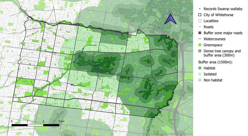
Table 1.1 Summary of total species richness

                       Only in Whitehorse                  Only in buffer          Both in Whitehorse and buffer   Total

Main group        Introduced    Native        Total Introduced   Native     Total Introduced    Native     Total

Arachnids                           73          73                    7        7                    26       26        106
Birds                       3       32          35          3       26        29          12      190       202        266
Frogs                       1         2          3                    2        2                    10       10            15
Fungi                              113         113                  49        49           3        65       68        230
Insects                            711         711                  22        22           2      100       102        835
Mammals                     2         5          7                    2        2           6        18       24            33
Other
                                    16          16                    9        9           2        10       12            37
invertebrates
Plants                   282       286         568         48       87      135          218      321       539      1242
Reptiles                              6          6                    3        3                    11       11            20

Totals                   288      1244        1532         51      207      258          243      751       994      2784

Table 1.2 Summary of species richness for Arachnids

                       Only in Whitehorse                  Only in buffer          Both in Whitehorse and buffer   Total

Main group        Introduced    Native        Total Introduced   Native     Total Introduced    Native     Total

Harvestmen                                                            1        1                                            1
Mites                                1           1                    2        2                                            3
Pseudoscorpi-
                                     2           2                                                                          2
ons
Scorpions                            1           1                                                                          1
Spiders                             69         69                     4        4                    26       26            99

Totals                              73         73                     7        7                    26       26        106

2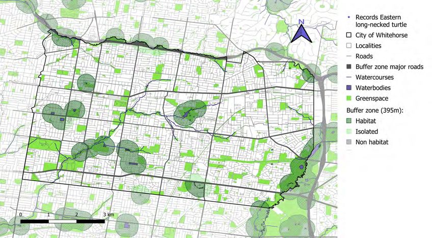
Table 1.3 Summary of species richness for Birds

                        Only in Whitehorse                Only in buffer          Both in Whitehorse and buffer   Total

Main group        Introduced     Native      Total Introduced   Native     Total Introduced    Native     Total

Birds of prey                         4            4                 3        3                    16       16            23
Bushbirds                             5            5       1         1        2            2       20       22            29
Parrots                     1                      1       1         2        3                    20       20            24
Seabirds                              3            3                 9        9                    11       11            23
Songbirds                   1        15           16       1         7        8            9       89       98        122
Waterbirds                  1         5            6                 4        4            1       34       35            45

Totals                      3        32           35       3       26        29          12       190      202        266

Table 1.4 Summary of species richness for Frogs

                        Only in Whitehorse                Only in buffer          Both in Whitehorse and buffer   Total

 Main group       Introduced     Native      Total Introduced   Native     Total Introduced    Native     Total

 Ground frogs               1                      1                                                3        3             4
 Tree frogs                           2            2                                                5        5             7
 Water frogs                                                         2        2                     2        2             4

 Totals                     1         2           3                  2        2                    10       10            15

Table 1.5 Summary of species richness for Fungi

                        Only in Whitehorse                Only in buffer          Both in Whitehorse and buffer   Total

 Main group       Introduced     Native      Total Introduced   Native     Total Introduced    Native     Total

 Club fungi                        101       101                   37        37            3       62       65        203
 Sac fungi                           12           12               12        12                     3        3            27

 Totals                            113       113                   49        49            3       65       68        230

                                                                                                                               3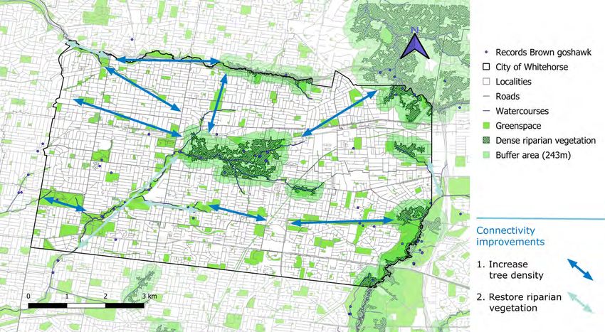
Table 1.6 Summary of species richness for Insects

                                      Only in Whitehorse                Only in buffer          Both in Whitehorse and buffer   Total
Main group                      Introduced     Native      Total Introduced   Native     Total Introduced    Native     Total
Alderflies                                            1       1                                                                          1
Ants                                                 16     16                                                    3        3            19
Bark lice                                             1       1                                                                          1
Bees                                                 25     25                                           1        1        2            27
Beetles                                             119    119                     7        7                    15       15        141
Butterflies                                          19     19                                          1        10       11            30
Caddisflies                                           3       3                                                                          3
Cicadas                                               4       4                    1        1                     2        2             7
Cockroaches                                           4       4                                                   2        2             6
Dragonflies and Damselflies                           3       3                    1        1                    13       13            17
Earwigs                                                                                                           1        1             1
Flies                                                33     33                     3        3                     7        7            43
Grasshoppers and Crickets                             5       5                    3        3                     2        2            10
Heteropteran bugs                                    23     23                     1        1                     2        2            26
Jumping plant lice                                    1       1                                                                          1
Lacewings                                            19     19                                                    1        1            20
Leafhoppers and Treehoppers                           5       5                                                                         5
Mantises                                                                           1        1                     2        2            3
Moths                                               372    372                     5        5                    33       33        410
Parasitoid wasps                                    18       18                                                                         18
Planthoppers                                          4       4                                                   1        1             5
Sawflies                                             13     13                                                                          13
Scale insects                                         2       2                                                   1        1             3
Stick insects                                         1       1                                                                          1
Stinging wasps                                       17     17                                                    4        4            21
Thrips                                                3       3                                                                          3
4Totals                                             711    711                   22       22            2      100       102        835
Table 1.7 Summary of species richness for Mammals
Only in Whitehorse Only in buffer Both in Whitehorse and buffer Total
Main group Introduced Native Total Introduced Native Total Introduced Native Total
Bats 1 1 2 2 7 7 10
Carnivore
1 1 2 2 3
mammals
Hares and
1 1 1
Rabbits
Hoofed
1 1 1
mammals
Marsupials 4 4 8 8 12
Mice and Rats 3 1 4 4
Platypus and
2 2 2
Echidnas
Totals 2 5 7 2 2 6 18 24 33
Table 1.8 Summary of species richness for Other invertebrates
Only in Whitehorse Only in buffer Both in Whitehorse and buffer Total
Main group Introduced Native Total Introduced Native Total Introduced Native Total
Centipedes 1 1 1
Crustaceans 2 2 3 3 3 3 8
Flatworms 7 7 1 1 8
Millepedes 1 1 1 1 2 3
Mollusks 4 4 6 6 1 5 6 16
Springtails 1 1 1
Totals 16 16 9 9 2 10 12 37
5Table 1.9 Summary of species richness for Plants
Only in Whitehorse Only in buffer Both in Whitehorse and buffer Total
Main group Introduced Native Total Introduced Native Total Introduced Native Total
Clubmosses 1 1 1 1 2
Conifers 6 6 1 1 7
Eudicots 207 139 346 24 42 66 150 184 334 746
Ferns 1 15 16 1 2 3 4 4 23
Liverworts 8 8 1 1 2 2 11
Magnoliids 1 1 2 2 2 4
Monocots 64 92 156 22 40 62 66 116 182 400
Mosses 2 30 32 1 2 3 1 12 13 48
Water lilies 1 1 1
Totals 282 286 568 48 87 135 218 321 539 1242
Table 1.10 Summary of species richness for Reptiles
Only in Whitehorse Only in buffer Both in Whitehorse and buffer Total
Main group Introduced Native Total Introduced Native Total Introduced Native Total
Geckos 1 1 1
Skinks 3 3 2 2 6 6 11
Snakes 1 1 1 1 3 3 5
Turtles 2 2 1 1 3
Totals 6 6 3 3 11 11 20
6Figure 1.1 Legend map of the City of Whitehorse for grid-based biodiversity summaries. Each cell is 500x500 m.
7Figure 1.2 Total species richness by cell. The City of Whitehorse has been divided in 500mx500m cells. Empty cells represent areas where no species have been recorded. 8
Figure 1.3 Species richness of arachnids by cell. The City of Whitehorse has been divided in 500mx500m cells. Empty cells represent areas where
no arachnid species have been recorded.

                                                                                                                                             9
Figure 1.4 Species richness of birds by cell. The City of Whitehorse has been divided in 500mx500m cells. Empty cells represent areas where no bird species have been recorded. 10
Figure 1.5 Species richness of amphibians by cell. The City of Whitehorse has been divided in 500mx500m cells. Empty cells represent areas
where no amphibian species have been recorded.

                                                                                                                                       11
Figure 1.6 Species richness of fungi by cell. The City of Whitehorse has been divided in 500mx500m cells. Empty cells represent areas where no fungi species have been recorded. 12
Figure 1.7 Species richness of insects by cell. The City of Whitehorse has been divided in 500mx500m cells. Empty cells represent areas where
no insect species have been recorded.

                                                                                                                                          13
Figure 1.8 Species richness of other invertebrates by cell. The City of Whitehorse has been divided in 500mx500m cells. Empty cells represent areas where no other invertebrate species have been recorded. 14
Figure 1.9 Species richness of mammals by cell. The City of Whitehorse has been divided in 500mx500m cells. Empty cells represent areas where
no mammal species have been recorded.

                                                                                                                                          15
Figure 1.10 Species richness of plants by cell. The City of Whitehorse has been divided in 500mx500m cells. Empty cells represent areas where no plant species have been recorded. 16
Figure 1.11 Species richness of reptiles by cell. The City of Whitehorse has been divided in 500mx500m cells. Empty cells represent areas where
no reptile species have been recorded.

                                                                                                                                            17
and space (proportion of records in Whitehorse community science crowdsourced biological
versus the surrounding 1 km buffer). surveys (e.g. Biodiversity Blitz or City Nature
Challenge).
The tables summarise over 157,000 records
collected between 1770 and 2020 in the City of In the areas of the municipality where there are
Whitehorse and a 1km outside buffer within its biodiversity records, the locations with the highest
adjacent LGAs. Approximately 13,000 of these species richness for most taxa correspond with
records came from datasets provided by the City of known natural areas within the municipality,
Whitehorse. In total, the records represent 2,784 such as Blackburn Lake Sanctuary, Bellbird Dell
species. Reserve, and the Mullum Mullum Creek corridor
and Yarran Dheran Reserve. While these locations
These tables were provided to Whitehorse City
are likely to support a higher diversity of species, it
Council as Excel spreedsheets. Summaries of the
is possible that other areas within the municipality
number of species found exclusively in the City of
may support similar levels of diversity but have
Whitehorse, exclusively in the buffer area, and in
simply not been sampled with the same level of
both areas are given in Table 1.1-1.10.
effort. The information obtained through additional
Distribution of biodiversity based on Atlas of Living surveys will help to fill out a more complete picture
Australia records and other datasets of biodiversity across the municipality.
We mapped the distribution of records and the
species richness for the main taxonomic groups
using a 500 m x 500 m grid across the City of
Whitehorse (Figures 1.1 - 1.11). Cells with a deeper
shade indicate a higher number of species present.
With the exception of birds and plants, there are
large areas of the municipality where there are
no data in terms of species records. These areas
could be used as focal locations for more detailed
biodiversity surveys by taxa experts, or through
182 Habitat connectivity
2.1 Where are the important habitat and Dispersal heights (ground vs aerial) or modes
connectivity opportunities for biodiversity? (flying vs walking)
In collaboration with the Whitehorse City Council Taxonomic groups (e.g. amphibians, birds,
project team, we identified a suite of 12 focal taxa insects, mammals, reptiles)
to represent a (1) diverse array of taxonomic and
functional groups of species within the municipality, as well as:
and (2) range of different habitat requirements and
movement capabilities. While habitat connectivity Number of records in the municipality
is also an important consideration for plants, for
the purpose of this project the focus will be on Habitat requirements and dispersal information
mobile animal species. related to each species and the ability to
represent this using existing spatial data sources
In a multistep process, the 12 focal taxa were
conceptualised to represent a balanced selection Stories and meanings relevant to Whitehorse
in terms of: City Council initiatives and local interest.
Habitat requirements (e.g. canopy, midstorey, The twelve focal taxa are presented in Table 2.1 and
understory, riparian/wetland) Figure 2.1. The selected taxa belong to many of the
important species groups and habitat characteristics
Dispersal distances present in Whitehorse. Collectively they represent
a diversity of (1) movements (ground and aerial);
19(a) (b) (c)
(d) (e) (f)
(2) dispersal distances (0 m – 1500 m); (3) habitat 2.2 Habitat connectivity maps for individual
needs (water, open areas, tree canopy, remnant focal groups
vegetation, dark areas); and (4) the main animal
groups present within Whitehorse, including one As the focal taxa were selected to deliberately
amphibian, three birds, two insects, four mammals represent a range of habitat requirements and
(one bat and three marsupials), and two reptiles. dispersal characteristics, it is helpful to look at the
individual connectivity maps to understand the
different scales and opportunities for connectivity
within Whitehorse. Here, we present the habitat
20(g) (h) (i)
(j) (k) (l)
Figure 2.1 This and previous page Focal taxa of the study; (a) Spotted pardalote, (b) Eastern yellow robin, (c) Brown goshawk, (d) Sugar
glider, (e) Common ringtail possum, (f) Swamp wallaby, (g) Little forest bat, (h) Common blue-tongued lizard, (i) Eastern long-necked turtle, (j)
Pobblebonk, (k) Blue-banded bee and (l) Common imperial blue. Photos by Mark Sanders (g), David Cook (e, l), Ed Dunens (i), David Curtis (a,
c), Patrick Kavanagh (b, d, f), David Nelson (j) and Luis Mata (k).
connectivity maps for each of the focal taxa. In the 2.2.1. Spotted pardalote | Pardalotus
next section, this information will be synthesised to punctatus
provide an overall understanding of wildlife habitat
connectivity, and where there are opportunities The spotted pardalote is one of Australia’s smallest
to strengthen connectivity for multiple species birds. They build their nests in horizontal tunnels
through targeted actions. dug into the soil of creek banks, embankments,
21Table 2.1 Characteristics of the twelve focal taxa
Focal taxa Scientific name Movement Dispersal distance Habitat connectivity representation
Spotted pardalote Pardalotus punctatus Aerial Medium from tree canopy Buffer of varying size around patches with Eucalyptus
tree canopy; 150 m for patches 6 Ha
Eastern yellow robin Eopsaltria australis Aerial Medium from shrub areas Greenspace patch size >5 Ha. 75 m buffer around
greenspaces, 189 m buffer around greenspaces with
remnant vegetation
Brown goshawk Accipiter fasciatus Aerial Large from riparian dense 234 m buffer around riparian dense vegetation
vegetation
Sugar glider Petaurus breviceps Arboreal Short from dense 30 m buffer around open space patches with remnant
vegetation vegetation
Common ringtail Pseudocheirus Arboreal Medium from dense 400 m buffer around areas of dense vegetation
possum peregrinus vegetation
Swamp wallaby Wallabia bicolor Ground Large around dense 300 m buffer around areas of dense vegetation to
vegetation identify core habitat, and 1500 m buffer to identify
islands of dense vegetation forming a corridor
Little forest bat Vespadelus vulturnus Aerial Medium within darker 600 m buffer around open space patches with
nocturnal canopy areas remnant vegetation, excluding areas with nocturnal
light levels above 9 nW/cm2/sr (ideallyTable 2.1 Cont. Characteristics of the twelve focal taxa
Focal taxa Scientific name Movement Dispersal distance Habitat connectivity representation
Pobblebonk Limnodynastes Ground Medium around water 200 m buffer around watercourses and waterbodies
dumerilii
Blue-banded bees Amegilla asserta and Aerial Medium around areas 350m buffer around open space patches with records
Amegilla chlorocyanea with specific indigenous of known host plants (Dianella spp., Pelargonium
plant species australe, Goodenia ovata, Isotoma axillaris, Crowea
exalata, Bulbine bulbosa, and Wahlenbergia spp.)
Common imperial blue Jalmenus evagoras Aerial Limited around specific 0 m buffer around open space patches with records
Acacia species of known host plants (Acacia mearnsii, A. implexa,
and A. melanoxylon)
quarries, rabbit burrows, or potted plants in buffer for this species, presented in pale green in
gardens. Spotted pardalotes forage in gum tree the map, as 150m around greenspace smaller than
crowns, plucking psyllids and other invertebrates 1 ha, 500 m around those between 1 and 6 ha, and
from leaves (Birdlife Australia 2021). 1.3 km for greenspaces larger than 6 ha. The larger
the area of the greenspace with Eucalyptus trees,
The map of habitat connectivity for the spotted the more likely it is that the pardalotes visit the site
pardalote is shown in Fig. 2.2a. Dark green areas from further away. Watercourses are shown in the
represent open space that coincides with records of map in dark blue.
Eucalyptus, a genus on which spotted pardalote are
know to forage. Spotted pardalote individuals have Habitat connectivity for the spotted pardalote
been found to fly between 150 m and 1.3 km from within the City of Whitehorse could be promoted
their nesting sites to find food (Doerr et al. 2004). by increasing the presence of gum trees on open
Following this work, we defined the connectivity greenspaces (for foraging), particularly those around
23Figure 2.2a Map of habitat connectivity for the spotted pardalote Pardalotus punctatus. 24
Figure 2.2b Suggested actions to improve habitat connectivity for the spotted pardalote Pardalotus punctatus.

                                                                                                                25
Figure 2.3a Map of habitat connectivity for the eastern yellow robin Eopsaltria australis. 26
Figure 2.3b Suggested actions to improve habitat connectivity for the eastern yellow robin Eopsaltria australis.

                                                                                                                   27
Figure 2.4a Map of habitat connectivity for the brown goshawk Accipiter fasciatus. 28
Figure 2.4b Suggested actions to improve habitat connectivity for the brown goshawk Accipiter fasciatus.

                                                                                                           29
watercourses, and restoring riparian habitats (for These distances are based on Doerr et al. (2011).
nesting spots). Fig. 2.2b shows suggested locations Fig. 2.6a assumes that greenspaces with remnant
for actions to improve habitat connectivity. vegetation provide habitat of better quality and
support longer dispersal distance for robins.
Although these connectivity maps have been
developed for the spotted pardalote, they are Actions that improve habitat connectivity for the
representative of the connectivity limitations and eastern yellow robin rely on habitat restoration,
opportunities that exist for other small birds living particularly on increasing the shrub and ground
in the City of Whitehorse, especially those using cover layers of greenspaces with no remnant
native tree canopies for foraging. vegetation. Fig. 2.3b suggests locations in the City
of Whitehorse for actions of habitat restoration.
2.2.2. Eastern yellow robin | Eopsaltria
australis The connectivity maps developed for the eastern
yellow robin can be extrapolated to other small
Eastern yellow robins live in forests and woodlands, insectivorous birds living in the City of Whitehorse,
usually with a tall shrub layer and sparse ground especially those nesting in remnant or shrubby
cover, and are also common in urban greenspaces vegetation.
(Birdlife Australia 2021). They feed on insects,
spiders, and other arthropods. 2.2.3. Brown goshawk | Accipiter fasciatus
The map of habitat connectivity for the eastern Brown goshawks occur across most of Australia.
yellow robin is shown in Fig. 2.3a. Greenspaces are They prey predominantly on medium-sized birds,
highlighted in bright green and those with remnant but also feed on small mammals, reptiles, and
vegetation in dark green. Habitat for this species insects (Birdlife Australia 2021). Brown goshawks
is represented by greenspaces larger than 5 ha are found in most timbered habitats, and nest close
(Higgins and Peter 2002), surrounded by a buffer to aquatic habitats (Birdlife Australia 2021).
area of 75 m, if they have no remnant vegetation
left, or 189 m, if they have remnant vegetation.
30The map of habitat connectivity for the brown 2.2.4. Sugar glider | Petaurus breviceps
goshawk is shown in Fig. 2.4a. Areas with dense
riparian vegetation are marked in dark green, with Sugar gliders live in forests and woodlands. They
a buffer area of 243 m around them in pale green. are most active at night, sleeping by day in nests
This number is a conservative measure of the mean made of leaves in tree hollows. Sugar gliders have
distance to the nearest neighbour between nests a membrane extending from their fifth finger to
(Riddell 2015). Watercourses and areas of open their ankle, which enables them to glide up to 50
space are also shown in blue and bright green. m between trees (Australian Museum 2021).
These elements may also provide smaller, suitable
patches (e.g. isolated large trees) of habitat for The map of habitat connectivity for the sugar glider
nesting and feeding for the brown goshawk. The is shown in Fig. 2.5a. Greenspaces with remnant
lack of open greenspaces with trees that can act as vegetation are considered to be suitable habitat for
stepping stones between aquatic habitats may act this species, and are shown in dark green. A buffer
as a habitat disruptor for the brown goshawk. area of 30 m around these greenspaces is presented
in pale green and represents the dispersal ability of
Habitat connectivity for the brown goshawk the species (Suckling 1984; Caryl et al. 2013).
within the City of Whitehorse could be promoted
by increasing the density of trees on open green Increased habitat connectivity for sugar gliders
spaces and improving the health of riparian requires habitat restoration, with an emphasis on
vegetation along watercourses. Fig. 2.4b shows the conservation of old trees inside and outside
suggested locations for actions to improve habitat greenspaces. In Fig. 2.5b, we suggest areas in the
connectivity. City of Whitehorse where habitat restoration may
benefit connectivity for the species.
The habitat connectivity limitations highlighted in
these maps may apply to other birds that utilize The habitat connectivity maps developed for the
denser tree cover. The larger areas of connected sugar glider can be used to understand connectivity
open space may also favour other raptors such as limitations that apply to other arboreal marsupials,
the collared sparrowhawk Accipiter cirrocephalus. such as the narrow-toed feather-tailed glider
Acrobates pygmaeus.
31Figure 2.5a Map of habitat connectivity for the sugar glider Petaurus breviceps. 32
Figure 2.5b Suggested actions to improve habitat connectivity for the sugar glider Petaurus breviceps.
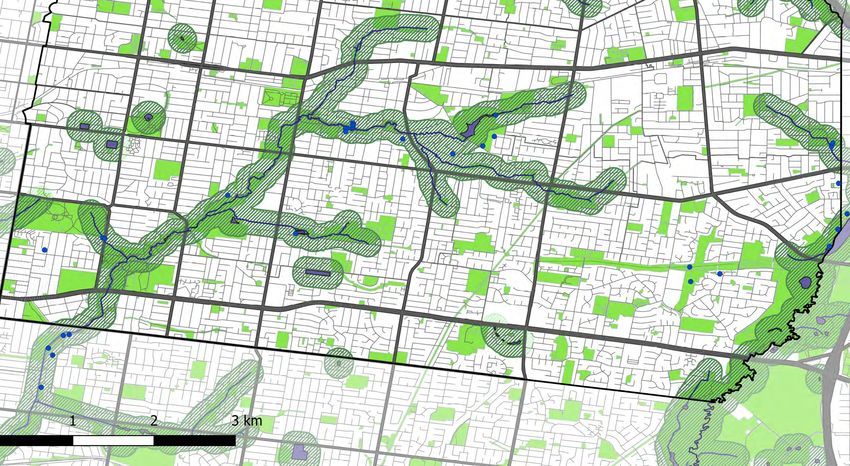
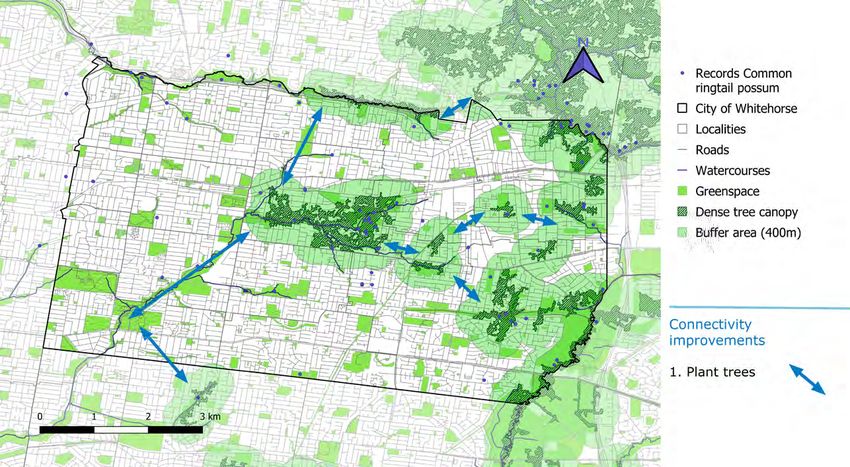
33Figure 2.6a Map of habitat connectivity for the common ringtail possum Pseudocheirus peregrinus. 34
Figure 2.6b Suggested actions to improve habitat connectivity for the common ringtail possum Pseudocheirus peregrinus.
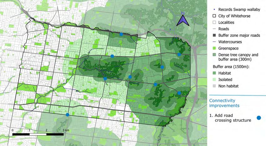
35Figure 2.7a Map of habitat connectivity for the swamp wallaby Wallabia bicolor. 36
Figure 2.7b Suggested actions to improve habitat connectivity for the swamp wallaby Wallabia bicolor.

                                                                                                        37
2.2.5. Common ringtail possum | Habitat and connectivity patterns highlighted
Pseudocheirus peregrinus in these maps also apply to other marsupials
found within the Whitehorse City Council, such
Common ringtail possums are tree-dwelling, living as the eastern ring-tailed possum Pseudocheirus
in forests, woodlands, rainforests, dense scrub, and peregrinus.
urban greenspaces. They have adapted to live in
close association with humans and are often seen 2.2.6. Swamp wallaby | Wallabia bicolor
in residential gardens at night. Common ringtail
possums are nocturnal and feed on leaves, flowers, Swamp wallabies live in thick forest undergrowth
and fruits (Australian Museum 2021). or sandstone heath. They feed on a variety of plants,
including introduced and native shrubs, grasses,
The map of habitat connectivity for the common and ferns (Australian Museum 2021).
ringtail possum is shown in Fig. 2.6a. Areas with
dense tree canopy within the City of Whitehorse The habitat connectivity map for the swamp
are presented in dark green, surrounded by a buffer wallaby is shown in Fig. 2.7a. Dark green shows
distance of 400 m in pale green. This number is areas of dense vegetation surrounded by a buffer
based on the distance that western ringtail possums of 300 m (Downes et al. 1997), representing the
were observed from high quality vegetation on the core suitable habitat for swamp wallabies and their
Swan Coastal Plain of WA (Shedley and Williams average dispersal distance. We also present a wider
2014). buffer zone, of 1500 m around dense vegetation
(Downes et al. 1997), which aims to identify
Actions to increase habitat connectivity for islands of dense vegetation (i.e. corridor) that could
common ringtail possums rely largely on habitat provide opportunities for longer dispersal for the
restoration in open greenspaces, with particular species. The paler green tone in this second buffer
emphasis on increasing tree density around areas represents areas within Whitehorse that remain
with already dense tree canopy. Fig. 2.6b shows unavailable for the wallaby due to the presence of
possible areas within Whitehorse where these major roads (in grey), which represent a mortality
actions are recommended. risk for the species. As such, we classified these
38areas, that otherwise would be part of the wider considered to be areas of open space containing
habitat for wallabies, as isolated in the map. remnant vegetation, and they are unlikely to move
across landscapes that are brightly lit. Haddock
Increased habitat connectivity for the swamp and colleagues (2019) reported they are sensitive
wallaby relies on actions that reduce the risk of to higher levels of artificial light at night, foraging
collision with motor vehicles. These include the more actively in the dark interior and edges of
addition of below or above road crossing structures bushland patches, rather than the more brightly lit
for wildlife and limited traffic volume or speed edges where streetlights were present.
around areas of dense vegetation and greenspaces.
See Fig. 2.7b for suggested areas where actions The map of habitat connectivity for the little forest
could be prioritised. bat is shown in Figure 2.8a. Open space areas with
remnant vegetation, suitable for nesting, are shown
Although these connectivity maps have been in dark green. They are surrounded by a pale green
developed for the swamp wallaby, they are buffer of 600 m, which represents the average
representative of the connectivity limitations and distance this species has been captured away from
opportunities that exist for other large marsupials the nest (i.e. average flight distance; Gonsalves et
living in the City of Whitehorse, such as the eastern al. 2013). Within these buffers, grey areas represent
grey kangaroo Macropus giganteus. They may locations with dark night light (i.e. average nighttime
also benefit medium-bodied terrestrial marsupials radiance below 9 nW/cm2/sr). These areas can be
such as the short-beaked echidna Tachyglossus considered for habitat restoration actions such as
aculeatus. planting additional tree and shrub species the little
forest bats are known to feed near. The areas in
2.2.7. Little forest bat | Vespadelus vulturnus pale yellow are locations with more bright night
light (i.e. average nighttime radiance above 9 nW/
Little forest bats roost in hollows in old trees, cm2/sr). In these areas, habitat connectivity could
buildings, and timber stacks, and prey on small be improved by reducing light levels down as far as
insects. Their colonies are comprised of up to 50 possible through the use of wildlife friendly lighting
bats (Australian Museum 2021). Their habitat is initiatives. Examples of these initiatives include
39Figure 2.8a Map of habitat connectivity for the little forest bat Vespadelus vulturnus. 40
Figure 2.8b Suggested actions to improve habitat connectivity for the Little forest bat Vespadelus vulturnus.
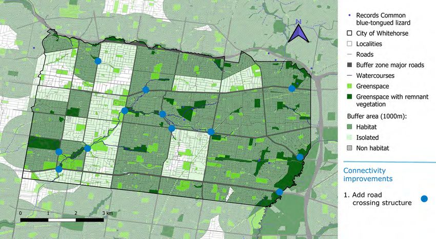
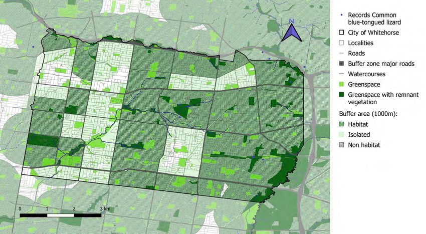
41Figure 2.9a Map of habitat connectivity for the common blue-tongued lizard Tiliqua scincoides. 42
Figure 2.9b Suggested actions to improve habitat connectivity for the common blue-tongued lizard Tiliqua scincoides.

                                                                                                                       43
Figure 2.10a Map of habitat connectivity for the eastern long-necked turtle Chelodina longicollis. 44
Figure 2.10b Suggested actions to improve habitat connectivity for the eastern long-necked turtle Chelodina longicollis.

                                                                                                                           45
physical shielding of the streetlights to prevent 2.2.8. Common blue-tongued lizard |
upward spill, reduction of the light intensity (lux), Tiliqua scincoides
or installation of timers that allow some lights to
be dimmed or turned off during periods of little Common blue-tongued lizards are amongst the
human activity (e.g., 1am – 4 am). largest members of the skink family, growing to
almost 60 cm in length. They live in open country
The other areas in the municipality with darker with lots of ground cover such as tussocky grasses
night time lights (grey areas) that occur outside of or leaf litter, and shelter at night in amongst the
the 600 m buffer also have potential for habitat leaf litter or under rocks and logs. Common blue-
restoration, through actions such as increasing tongued lizards feed on a wide variety of plants
greenspace area or providing additional habitat, and animals (Australian Museum 2021). Major
particularly when close to areas of open space roads represent a barrier for the dispersal of this
with remnant vegetation. species (Koenig et al 2002).
Suggested locations for different habitat The map of habitat connectivity for the common
connectivity actions for little forest bat are shown blue-tongued lizard is shown in Fig. 2.9a. In
in Figure 2.8b. dark green are greenspace areas with remnant
vegetation, surrounded by a buffer zone of 1 km
These maps of habitat connectivity are that represents the species’ average dispersal
representative of the issues faced by other microbats distance (Kirk et al. 2018). Within this buffer zone,
in the City of Whitehorse, including, for example areas that can be accessed from patches of remnant
the lesser long-eared bat Nyctophilus geoffroyi, the vegetation are shown in dark green, while areas that
chocolate wattled bat Chalinolobus morio and the are unavailable due to the presence of major roads
Gould’s long-eared bat Nyctophilus gouldi. (in grey) are shown in pale green. We classified
these areas as isolated for the blue-tongued lizard,
given that they would need to cross a major road in
order to get access to them. Greenspaces without
remnant vegetation are presented in bright green
and watercourses in dark blue.
46Connectivity for this species in the City of particularly those which are located close to
Whitehorse relies mostly on actions that reduce the drainage ditches. Rees and colleagues (2009) noted
risk of collision with motor vehicles when moving that eastern long-necked turtles in urban areas
among different patches of suitable habitat. This around Canberra did not use terrestrial sites, and
can be achieved by building crossing structures all of their movement was located along drainage
that wildlife can use above or below the roads. ditches. They are able to use road underpasses
Habitat restoration in greenspaces with no remnant when available, which can reduce the number of
vegetation, especially the increase of ground cover, individuals killed by cars (Rees et al. 2009).
for example with indigenous grasses, would be
beneficial to facilitate the species movement across The map of habitat connectivity for the eastern long-
the City of Whitehorse. We suggest locations where necked turtle is shown in Figure 2.10a. Waterbodies
these actions would improve habitat connectivity in the City of Whitehorse are represented by dark
in Fig. 2.9b. blue. Waterbodies are surrounded by a buffer
of 395 m, which represents the turtle’s dispersal
The maps of habitat connectivity developed for ability based on a radio-tracking study by Roe and
the common blue-tongued lizard can be used to Georges (2007). These authors recorded 95% of
understand issues faced by other lizards, skinks turtle locations within 395 m of the nearest wetland.
and snakes found in the City of Whitehorse. Areas within this buffer are considered unavailable
to turtles, if they need to cross a major road to
2.2.9. Eastern long-necked turtle | access them. We have classified these areas within
Chelodina longicollis the buffer as isolated habitat for the species and
represented them in pale green in the map. Major
Eastern long-necked turtles live in freshwater roads were defined as anything that is Class Code
habitats. They feed on aquatic invertebrates, 3 or lower in the VicMap Transport Roads dataset,
tadpoles, and small fishes. Hatchlings are eaten by as these are usually multi-laned and support traffic
fish and birds, and adults may be killed by cars speeds above 60 km/h. We also show watercourses
while moving overland (Australian Museum 2021). in the City of Whitehorse in dark blue.
Their habitat is considered to be waterbodies,
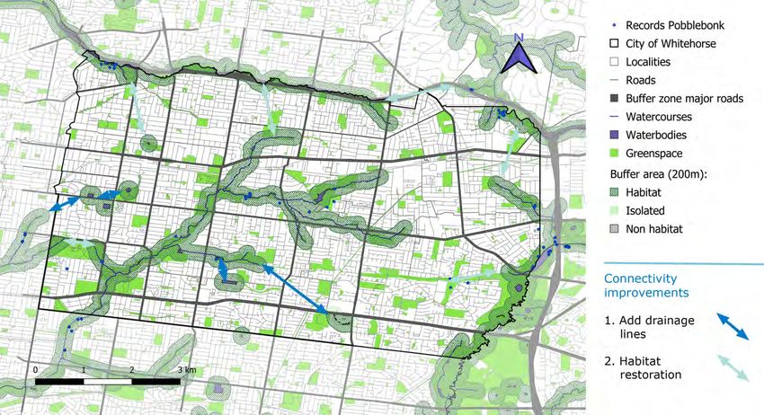
47Figure 2.11a Map of habitat connectivity for the pobblebonk Limnodynastes dumerilii. 48
Figure 2.11b Suggested actions to improve habitat connectivity for the pobblebonk Limnodynastes dumerilii.

                                                                                                             49
Figure 2.12a Map of habitat connectivity for the blue-banded bees Amegilla asserta and Amegilla chlorocyanea. 50
Figure 2.12b Suggested actions to improve habitat connectivity for the blue-banded bees Amegilla asserta and Amegilla chlorocyanea.

                                                                                                                                      51
Figure 2.13a Map of habitat connectivity for the common imperial blue Jalmenus evagoras. 52
Figure 2.13b Suggested actions to improve habitat connectivity for the common imperial blue Jalmenus evagoras.

                                                                                                                 53
Additional drainage lines that connect waterbodies and waterbodies. They burrow in loamy soils and
to the larger stream network could significantly emerge to feed and breed after rains (Frogwatch SA
increase connectivity for this species by supporting 2021). They place their eggs in points of still water,
the movement of the individuals. The construction where they hatch and their tadpoles grow (State of
of additional ponds along an existing riparian area Victoria 2017). Pobblebonks are sensitive to roads,
could also promote the dispersal of the species by and are less likely to occur at ponds with higher
decreasing the travel distance between suitable density of roads in the surrounding 500 m (Parris
aquatic habitats. Suggested locations for different 2006).
habitat connectivity actions for eastern long-
necked turtles are shown in Figure 2.10b. The map of habitat connectivity for the pobblebonk
is shown in Fig. 2.11a. Waterbodies and
The connectivity maps developed for the eastern watercourses are shown in dark blue, surrounded
long-necked turtle can be extrapolated to other by a dark green buffer zone of 200 m that represents
riparian and wetland dependent species such as the average distance around aquatic habitats that
the Rakali Hydromys chrysogaster or other turtle are used by a similar sized frog (growling grass frog
species living in the City of Whitehorse, such as Litoria raniformis) (State of Victoria 2013). Major
the Murray river turtle Emydura macquarii and the roads are considered a disruptor for this species
broad-shelled turtle Chelodina expansa. and therefore sections of the buffer that can only
be accessed by crossing a major road (in grey) are
2.2.10. Pobblebonk | Limnodynastes considered unavailable and classified as isolated in
dumerilii the map. These isolated parts of otherwise suitable
habitat are presented in pale green.
Pobblebonks, also known as the southern
bullfrog or the eastern banjo frog, live in a wide Additional drainage lines that connect isolated
range of habitats, including urban, heath, and waterbodies to the larger stream network could
sclerophyll forest areas close or around wetlands significantly increase connectivity for this species.
The improvement of riparian vegetation as well
54as vegetation in close-by greenspaces could also bluebells (genus Wahlenbergia). They have also
promote the dispersal of the species by providing been recorded on a few plant species that are not
suitable nesting habitat in areas along the creek indigenous to Victoria (e.g. species of Eremophila,
that may be suboptimal at the moment. Suggested Westringia, and Pimelea), as well as some plant
locations for different habitat connectivity actions species that have been introduced into Australia
for pobblebonks are shown in Figure 2.11b. by the ornamental gardening industry (e.g. species
of Salvia).
The connectivity maps developed for the
pobblebonk highlight connectivity opportunities The map of habitat connectivity for blue-banded
and limitations for other native ground frogs living bees is shown in Fig. 2.12a. Dark green areas
in the City of Whitehorse, such as the striped marsh represent open space that coincides with records
frog Limnodynastes peronii and the spotted marsh of the indigenous plant species listed above. The
frog Limnodynastes tasmaniensis. pale green buffers represent the mean dispersal
distance of these bees (350 m; Kirk et al. 2018).
2.2.11. Blue-banded bees | Amegilla asserta
and Amegilla chlorocyanea Habitat connectivity for blue-banded bees could
be improve by increasing the amount and coverage
Blue-banded bees are solitary bee, building their of the indigenous species that the bees are
nest in shallow burrows in clay soil or mudbricks known to forage on in public greenspaces across
(Aussie Bees 2021). Adult blue-banded bees Whitehorse, as well as promoting the use of these
in Greater Melbourne feed on a small range of plant species in private gardens by Whitehorse
indigenous plant species, including flax-lilies residents. In both cases, these actions would be
(genus Dianella), austral stork’s-bill (Pelargonium concomitantly implemented with improvements of
australe), hop goodenia (Goodenia ovata), showy the bees nesting requirements. Suggested locations
isotome (Isotoma axillaris), small crowea (Crowea within the City of Whitehorse public greenspaces
exalata), bulbine lily (Bulbine bulbosa), and to implement these actions are shown in Fig. 2.12b.
55The connectivity maps developed for the blue- green areas represent open space that coincide
banded bees heavily rely on the specificity with Atlas of Living Australia records of the three
between these insect species and the indigenous wattle species that are local hosts for this butterfly.
species they are attracted to. Despite not directly As this species displays high fidelity to a site, it is
applicable to show habitat connectivity patterns unlikely to move far from an individual wattle tree,
for other pollinators, the same approach could be and therefore, we did not add a buffer area for
used to develop specific habitat connectivity maps dispersal around these greenspaces.
for other insects with well-known host specificity.
Actions to increase connectivity for this species
2.2.12. Common imperial blue | Jalmenus largely involve extending the planting of the host
evagoras wattle species in areas adjacent to populations of
common imperial blues, potentially in a staged
Adult common imperial blues fly close to the approach where the first stage focuses on shorter
ground around their food plant or close to their connections, and the second stage takes a longer-
breeding habitat (Bradby 2016). They live in term approach. Suggested locations for these
woodland, open-forests, foothills, and montane actions are shown in Figure 2.13b.
areas. Common imperial blues caterpillars are
attended by meat ants (genus Iridomyrmex) and As for the connectivity maps developed for the
feed on a range of wattles, including the black blue-banded bees, the maps developed for the
wattle Acacia mearnsii. Their habitat within the Common imperial blue butterfly heavily rely
City of Whitehorse is considered to be areas of on the specificity between the butterfly and the
open space that contain trees of Acacia mearnsii,indigenous species they are attracted to. Again,
Acacia melanoxylon, or Acacia implexa. a same methodological approach could be used
to develop specific habitat connectivity maps for
The map of habitat connectivity for the common other butterflies with well-known host preferences.
imperial blue is shown in Figure 2.13a. The dark
563 Synthesised wildlife habitat connectivity
maps for the City of Whitehorse
While understanding the individual habitat Management actions that can improve the benefits
connectivity requirements of different focal species of each corridor are presented in Table 3.1, along
can be important, it makes sense to look more with the functional groups (represented by the
closely for synergies amongst species as this will focal species) that can benefit from such actions.
help to identify synergies where a small number of Three corridor locations have been identified
actions can deliver multiple benefits. that are important for 7-10 different functional
groups. These are the Corridors 1 (Gardiners Creek
We identified 28 locations within the City of North), 2 (Gardiners Creek), and 3 (Forest Hill –
Whitehorse that are key areas of connectivity Heatherdale). Five additional corridors have been
(Figures 3.1 and 3.2). These corridors are either identified as being important habitat connectors
associated with known areas of connected for 6 of the different functional groups. These
greenspaces (such as Corridors 2, 4, 8, 10, 18, are Corridors 4 (Koonung Creek), 5 (Wattle Park
20 and 24), or represent key opportunities to – Gardiners Creek), 6 (Blackburn Lake – Antonio
develop actions to help connect existing corridors Park), 7 (Antonio Park – Heatherdale) and 8 (Fulton
- for example, Corridor 9 would help connect Rd).
Corridors 8 (Fulton Rd) and 18 (Jolimont Rd). A
Increasing connectivity in these corridors largely
synthesised picture of habitat connectivity across
involves undertaking work to increase the
the municipality for multiple terrestrial functional
complexity and connectivity of vegetation and
groups (represented by the focal taxa) is presented
provide drainage lines and additional wetlands
in Figures 3.1. Figure 3.2 presents a synthesised
for aquatic species. For several of these corridors,
picture of habitat connectivity for aquatic
these actions can be undertaken on public lands.
functional groups.
57Figure 3.1 Map of the main corridors for habitat connectivity in the City of Whitehorse for terrestrial species. See Table 3.1 for more information on each corridor. 58
Figure 3.2 Map of the main corridors for habitat connectivity in the City of Whitehorse for aquatic species. See Table 3.1 for more information
on each corridor.

                                                                                                                                                  59
Table 3.1 Main habitat connectivity corridors in the City of Whitehorse.
Corridor Functional group (focal taxa) Actions
1. Gardiners Creek North Spotted pardalote Restore riparian habitats
Eastern yellow robin Habitat restoration (Shrub layer)
Brown goshawk Increase tree density
Sugar glider Habitat restoration (Large trees within 30 m)
Common ringtail possum Plant trees
Little forest bat Reduce nighttime lights
Common blue-tongued lizard Add road crossing structure
Pobblebonk Habitat restoration (riparian vegetation, pond creation, drainage lines between ponds)
Blue-banded bees Plant indigenous host plants
Common imperial blue Plant Acacia spp. (stage 2)
2. Gardiner’s Creek Spotted pardalote Restore riparian habitats
Brown goshawk Restore riparian vegetation
Sugar glider Habitat restoration (Large trees within 30 m)
Common ringtail possum Plant trees
Common blue-tongued lizard Add road crossing structure
Eastern long-necked turtle Add ponds
Blue-banded bees Plant indigenous host plants
Common imperial blue Plant Acacia spp. (stage 1)
3. Forest Hill - Eastern yellow robin Habitat restoration (Shrub layer)
Heatherdale Brown goshawk Restore riparian vegetation
Sugar glider Habitat restoration (Large trees within 30 m)
Common ringtail possum Plant trees
Swamp wallaby Add road crossing structure
Blue-banded bees Plant indigenous host plants
Common imperial blue Plant Acacia spp. (stage 2)
60Table 3.1 Cont. Main habitat connectivity corridors in the City of Whitehorse.
Corridor Functional group (focal taxa) Actions
4. Koonung Creek Eastern yellow robin Habitat restoration (Shrub layer)
Brown goshawk Increase tree density and restore riparian vegetation
Sugar glider Habitat restoration (Large trees within 30 m)
Swamp wallaby Add road crossing structure
Little forest bat Reduce nighttime lights
Eastern long-necked turtle Add ponds
5. Wattle Park – Gardiner’s Brown goshawk Increase tree density
Creek Sugar glider Habitat restoration (Large trees within 30 m)
Little forest bat Reduce nighttime lights
Eastern long-necked turtle Add ponds
Pobblebonk Habitat restoration (riparian vegetation, pond creation, drainage lines between ponds)
Common imperial blue Plant Acacia spp. (stage 1)
6. Blackburn Lake – Spotted pardalote Plant Eucalyptus spp.
Antonio Park Eastern yellow robin Habitat restoration (Shrub layer)
Brown goshawk Increase tree density
Eastern long-necked turtle Add drainage lines
Pobblebonk Add drainage lines
Common imperial blue Plant Acacia spp. (stage 2)
7. Antonio Park - Sugar glider Habitat restoration (Large trees within 30 m)
Heatherdale Swamp wallaby Add road crossing structure
Little forest bat Reduce nighttime lights
Common blue-tongued lizard Add road crossing structure
Pobblebonk Habitat restoration (riparian vegetation, pond creation, drainage lines between ponds)
Blue-banded bees Plant indigenous host plants
61Table 3.1 Cont. Main habitat connectivity corridors in the City of Whitehorse.
Corridor Functional group (focal taxa) Actions
8. Fulton Rd Eastern yellow robin Habitat restoration (Shrub layer)
Brown goshawk Restore riparian vegetation
Sugar glider Habitat restoration (Large trees within 30 m)
Little forest bat Habitat restoration (more complex vegetation structure)
Blue-banded bees Plant indigenous host plants
Common imperial blue Plant Acacia spp. (stage 2)
9. Fulton Rd – Jolimont Rd Spotted pardalote Plant Eucalyptus spp.
Eastern yellow robin Habitat restoration (Shrub layer)
Brown goshawk Increase tree density
Little forest bat Reduce nighttime lights
Common imperial blue Plant Acacia spp. (stage 2)
10. Bellbird Dell – Brown goshawk Increase tree density
Dandenong Creek A Swamp wallaby Add road crossing structure
Pobblebonk Habitat restoration (riparian vegetation, pond creation, drainage lines between ponds)
Blue-banded bees Plant indigenous host plants
Common imperial blue Plant Acacia spp. (stage 2)
11. Eastern Freeway Spotted pardalote Plant Eucalyptus spp.
Eastern long-necked turtle Add ponds
Pobblebonk Habitat restoration (riparian vegetation, pond creation, drainage lines between ponds)
Blue-banded bees Plant indigenous host plants
12. Ruffey Creek Spotted pardalote Plant Eucalyptus sp.
Brown goshawk Increase tree density
Sugar glider Habitat restoration (Large trees within 30 m)
Blue-banded bees Plant indigenous host plants
62Table 3.1 Cont. Main habitat connectivity corridors in the City of Whitehorse.
Corridor Functional group (focal taxa) Actions
13. Gardiners Creek – Spotted pardalote Restore riparian habitats
Blackburn Lake Eastern long-necked turtle Add ponds
Blue-banded bees Plant indigenous host plants
Common imperial blue Plant Acacia spp. (stage 1)
14. Blackburn Lake – Forest Spotted pardalote Plant Eucalyptus spp. and restore riparian habitats
Hill Common ringtail possum Plant trees
Common blue-tongued lizard Add road crossing structure
Common imperial blue Plant Acacia spp. (stage 2)
15. Fulton Rd – Highbury Spotted pardalote Plant Eucalyptus spp.
Park Eastern long-necked turtle Add drainage lines
Pobblebonk Add drainage lines
Blue-banded bees Plant indigenous host plants
16. Wattle Park – Box Hill Eastern yellow robin Habitat restoration (Shrub layer)
Sugar glider Habitat restoration (Large trees within 30 m)
Little forest bat Reduce nighttime lights
17. Forest Hill – Bellbird Dell Spotted pardalote Plant Eucalyptus spp.
Sugar glider Habitat restoration (Large trees within 30 m)
Common ringtail possum Plant trees
18. Jolimont Rd Spotted pardalote Plant Eucalyptus spp.
Brown goshawk Increase tree density
Common imperial blue Plant Acacia spp. (stage 2)
19. Eley Rd Swamp wallaby Add road crossing structure
Little forest bat Habitat restoration (more complex vegetation structure)
Blue-banded bees Plant indigenous host plants
63Table 3.1 Cont. Main habitat connectivity corridors in the City of Whitehorse.
Corridor Functional group (focal taxa) Actions
20. Mullum Mullum Creek Eastern long-necked turtle Add ponds
Common imperial blue Plant Acacia spp. (stage 1)
21. Gawler Chain – Box Hill Spotted pardalote Plant Eucalyptus spp.
Eastern yellow robin Habitat restoration (Shrub layer)
22. Bellbird Dell Eastern yellow robin Habitat restoration (Shrub layer)
Sugar glider Habitat restoration (Large trees within 30 m)
23. Highbury Park – Forest Little forest bat Reduce nighttime lights
Hill Common imperial blue Plant Acacia spp. (stage 2)
24. Dandenong Creek Common blue-tongued lizard Add road crossing structure
Eastern long-necked turtle Add ponds
25. Gawler Chain Little forest bat Reduce nighttime lights and habitat restoration (more complex vegetation structure)
26. Gawler Chain – Brown goshawk Increase tree density
Gardiner’s Creek
27. Forest Hill – Sugar glider Habitat restoration (Large trees within 30 m)
Jolimont Rd
28. Bellbird Dell – Little Forest Bat Reduce nighttime lights
Dandenong Creek B
64Table 3.2 Relevant habitat connectivity corridors for each functional group (focal taxa). See Figures 3.1 and 3.2 for corridor location in the City of Whitehorse.
Functional group (focal taxa) Corridors
Spotted pardalote 1, 2, 6, 9, 11, 12, 13, 14, 15, 17, 18, 21
Eastern yellow robin 1, 3, 4, 6, 8, 9, 16, 21, 22
Brown goshawk 1, 2, 3, 4, 5, 6, 8, 9, 10, 12, 18, 26
Sugar glider 1, 2, 3, 4, 5, 7, 8, 12, 16, 17, 22, 27
Common ringtail possum 1, 2, 3, 14, 17
Swamp wallaby 3, 4, 7, 10, 19
Little forest bat 1, 4, 5, 7, 8, 9, 16, 19, 23, 25, 28
Common blue-tongued lizard 1, 2, 7, 14, 24
Eastern long-necked turtle 2, 4, 5, 6, 11, 13, 15, 20, 24
Pobblebonk 1, 2, 5, 6, 7, 10, 11, 15
Blue-banded bee 1, 2, 3, 7, 8, 10, 11, 12, 13, 15, 19
Common imperial blue 1, 2, 3, 5, 6, 8, 9, 10, 13, 14, 18, 20, 23
65Figure 3.3 Areas within the City of Whitehorse where private property could be purchased and transformed to increase wildlife connectivity through the corridors presented in Table 3.1 and shown in Figures 3.1 and 3.2. 66
Other corridors (e.g. Corridor 6) may require
alternative arrangements, such as targeting
Gardens For Wildlife activities or collaborating
with other custodians (e.g. VicTrack). In Figure
3.3, we highlight several areas where agreements
with private land owners or purchase of private
lands by the local government can greatly
increase the support these corridors can offer
for the movement of both terrestrial and aquatic
wildlife across the City of Whitehorse.

There are multiple locations with opportunities
to increase connectivity for all 12 of the
functional groups examined here (Table 3.2).
This is a positive position, since it reflects a well
distributed arrangement of the existing habitat
for these groups. Providing additional habitat,
reducing urban impacts, and creating stepping
stones to help these taxa move through the
landscape, will support populations of these
functional groups into the future. Focusing on
the targeted locations identified in Figure 3.1 will
allow a finer scale investigation and prioritization
of actions that are likely to be of great benefit to
the functional groups investigated in this study.

                                                        67
68
4 Technical Considerations

This report maps habitat connectivity across been cleared). Therefore, it is worth interpreting
a landscape, rather than modelling the likely these outcomes as a reliable first step to identify
movement of a target species. Habitat connectivity areas suitable for a more detailed investigation.
mapping uses the spatial arrangement of features
known to be similar to habitats where the focal
species occur. It is not a guarantee that the focal
taxa are already present at the site. It is simply a
tool for mapping where suitable habitat for that
species is already present in the landscape.

Any mapping exercise is only as detailed as the
spatial data available to use as input. For this report,
we were relying on data from the State of Victoria,
which is largely produced at the scale of the entire
state. For examining general connectivity patterns
across the entire municipality, this resolution of
data is acceptable. However, it is important to note
that a finer scale investigation may reveal additional
patches of potential habitat (e.g. waterbodies, small
areas of remnant vegetation) or instances where the
data do not reflect the current circumstances for
other reasons (e.g. an area of vegetation has now
                                                                                                  69
70
5 Summary

Whitehorse City Council is home to a wide               have been linked to these corridors will help to
diversity of plant and animal species, and supports     narrow the number of activities to target in those
a number of locations with key habitats for the         locations. Actions to support additional taxa can
12 functional groups investigated in this report.       potentially be considered at a later stage.
The existing corridors are largely located along
riparian areas, such as the Koonung Creek, the          This report was a desktop study that relied on
Dandenong Creek, the Gardiner’s Creek and the           existing spatial data. Collecting additional data at
Mullum Mullum Creek. Protecting these existing          a finer scale within specific corridor locations will
corridors, managing potential urban impacts, such       help provide a clearer picture of how to supplement
as artificial light at night, and adding additional     existing habitats with additional areas. Capturing
habitat within the corridors to help increase           this information will also assist future studies by
connectivity will help to enhance the habitat value     providing more detailed information that can allow
of these existing assets.                               for a more in depth mapping and investigation in
                                                        the future.
This study has also identified additional locations
for actions to help increase connectivity, often
through residential landscapes and terrestrial areas
between different riparian corridors. These locations
may provide additional challenges for delivering
increased connectivity, but the restoration actions
and the actions required to reduce urban impacts
are similar. Focusing on the functional groups that
                                                                                                          71
72
References

Australian Museum. (2021) https://australian. Downes SJ, Handasyde KA, Elgar MA. (1997)
museum/ Accessed on 9 April 2021.                    The use of corridors by mammals in fragmented
                                                     Australian eucalypt forests. Conservation Biology
Birdlife Australia. (2021) https://birdlife.org.au/ 11: 718-726.
Accessed on 9 April 2021.
                                                     Frogwatch SA. (2021) https://www.frogwatchsa.
Bradby M. (2016) The complete field guide com.au/ Accessed on 9 April 2021.
to butterflies of Australia. 2nd edition. CSIRO
Publishing.                                          Gonsalves L, Law B, Webb C, Monamy V. (2013)
                                                     Foraging ranges of insectivorous bats shift relative
Caryl F, Thompson K, van der Ree R. (2013). to changes in mosquito abundance. PLoS ONE 8:
Permeability of the urban matrix to arboreal gliding e64081.
mammals: Sugar gliders in Melbourne, Australia.
Austral Ecology 38: 609-616.                         Haddock JK, Threlfall CG, Law B, Hochuli DF.
                                                     (2019) Light pollution at the urban forest edge
Doerr E, Doerr V. (2005) Dispersal range analysis: negatively impacts insectivorous bats. Biological
quantifying individual variation in dispersal Conservation 236: 17-28.
behaviour. Oecologia 142: 1-10.
                                                     Higgins PJ, Peter JM. (2002) Handbook of
Doerr V, Doerr E, Davies M. (2011) Dispersal Australian, New Zealand and Antarctic Birds, vol.
behaviour of Brown Treecreepers predicts 6. Oxford University Press: Melbourne.
functional connectivity for several other woodland
birds. Emu 111: 71-83.                                                                                 73
You can also read