World Journal of Advanced Research and Reviews
←
→
Page content transcription
If your browser does not render page correctly, please read the page content below
World Journal of Advanced Research and Reviews, 2020, 07(02), 247–257 World Journal of Advanced Research and Reviews e-ISSN: 2581-9615, Cross Ref DOI: 10.30574/wjarr Journal homepage: https://www.wjarr.com (R E S E A R C H A R T I C L E ) Impact of the chemical properties of different soil units on the dynamics of vegetal biodiversity in the Benoue National Park and its Western and Northern peripheries Narcisse Soh Njekeu 1, *, Clautilde Megueni 1, Tchobsala 2, Sylvain Doua Aoudou 3 and Jean Paul Kevin Mbamba Mbamba 4 1 Department of Biological Sciences, Faculty of Science, University of Ngaoundéré, Cameroon, P.O.Box 454, Ngaoundéré. 2 Department of Biological Sciences, Faculty of Science, University of Maroua, Cameroon, P.O.Box 814, Maroua. 3 Department of Climatology, hydrology and pedology, University of Maroua, Cameroon. 4 Lobeke National Park, Cameroon. Publication history: Received on 07 August 2020; revised on 13 August 2020; accepted on 15 August 2020 Article DOI: https://doi.org/10.30574/wjarr.2020.7.2.0294 Abstract This work aims at determining the impact of soils' chemical properties on the dynamics of biodiversity in the Benoue National Park (BNP) of Cameroon and its peripheries (surrounding hunting concessions N ° 1, 4, 5 and 7). Nine, out of the sixteen soil units encountered in the BNP were studied, because of their accessibility. On each of these nine soil units studied, three elementary plots were materialized for the collection of soil samples and for the study of vegetation dynamics. The chemical parameters were evaluated according to appropriate methods and the dynamics of the vegetation was obtained by carrying out a floristic inventory. Heterogeneity was observed in the chemical parameters of the different soil units. Soil units S5 and S6 are the most damaged regarding their low organic matter content (0.95 ± 0.78%) and (1.02 ± 0.33%), their carbon (5.53 ± 4.54 g.kg-1) and (5.91 ± 1.93 g.kg-1) and nitrogen (1.20 ± 0.45 g.kg-1) and (1.89 ± 0.41 g.kg-1) contents and a very low C/N ratio (4.72 ± 3.96) and (3.29 ± 1.37) respectively. These soils also have a low floristic abundance S5 (22 ± 0.53 individuals) and S6 (8 ± 1.86 individuals) unlike S4 which has good chemical properties, according to its OM (5.60 ± 0.83 %) and carbon (32.49 ± 4.79 g.kg-1) content, and C/N ratio (22.38 ± 6.84). Consequently, its floristic abundance (75 ± 1.37 individuals) and diversity (18.42 %) are considerable. These results show that the degree of chemical degradation varies according to soils. Elsewhere chemical properties of the soil influence the dynamics and sustainability of the biodiversity. Keywords: Benoue National Park; Degradation; Soil unit; Biodiversity 1. Introduction The Northern Region of Cameroon has three national parks (Benoue, Faro and Bouba Ndjida) and 27 surrounding hunting concessions (ZIC) which occupy 45 % of the area [1]. These protected areas (PA) have been established for the protection and conservation of the biodiversity [2]. Unfortunately, population increase, development of anthropogenic activities around this protected areas and climate change pressure are obstacles to the achievement of the above- mentioned objectives [3]. The consequences (loss of biodiversity and soil fertility) of these phenomena are visible at several levels, namely on the biodiversity and the support soils [4] [5]. Subsequently, the Benoue National Park (BNP) and its western and northern peripheries which constituted our studied sites faced a loss in its biodiversity for several years [6]. To overcome the problem of biodiversity loss, many approaches have been tried in the BNP, aiming at guaranteeing ecological integrity and ensuring that the management of flora and fauna resources contributes to the fight against poverty [7]. Despite all these initiatives and the studies undertaken on the management and conservation of Corresponding author: Narcisse Soh Njekeu Department of Biological Sciences, Faculty of Science, University of Ngaoundéré, Cameroon, P.O.Box 454, Ngaoundéré. Copyright © 2020 Author(s) retain the copyright of this article. This article is published under the terms of the Creative Commons Attribution Liscense 4.0.

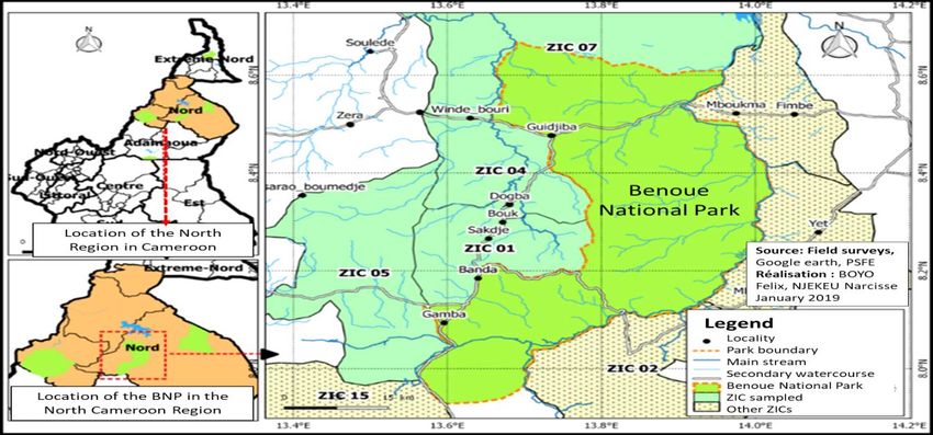
World Journal of Advanced Research and Reviews, 2020, 07(02), 247–257

biodiversity, the results remain mitigated and as time goes on, a decrease in local biodiversity is still observed [1]. For
instance, Afzelia Africana (highly prized by giraffes) is becoming scarce while several faunal species are threatened with
extinction. Moreover, the Lycaon (Lycaon pictus) and the western black rhinoceros / Central Africa (Diceros bicornis
longipes) are extinct since 2004 [8]. Between 2000 and 2013 in BNP, the hippopotamus population dropt to almost 50
% [8]. The main aspect that has not been considered in the studies carried out so far to justify the loss of biodiversity in
the BNP, is the undeniable relationship that exists between the flora and the soil. The soil is the nutrients reservoir of
plants, which in turn, constitute food source for animals in the given ecosystem [9]. Soil degradation is therefore a threat
not only for plants but also for animals [10] [11].

Soil degradation is a process of reducing or losing its productivity; it is also a deterioration of its physical, biological and
chemical properties [12] [13] [14]. According to IPBES [15], the soils are in a critical state, causing severe consequences
on biodiversity, climate change and the stability of our societies. Per year, 12 million hectares of soil stop fulfilling their
essential ecological role for biodiversity as a result of their degradation [16] [15]. Chemical soil degradation is of no less
importance compared to other forms of degradation but it is often overlooked [17].

Land degradation as a result of human activities exposes the planet to the sixth massive extinction of species [18].
According to this author [18], the protection of biodiversity and ecosystemic services that are vital in maintaining life
on earth and ensuring human well-being, avoiding, reducing, reversing, and restoring degraded lands are urgent
priorities. According to Humbel and Barbery [19], soils' degradation varies, depending on their respective bedrocks.
The last study was carried out in the present research site in 1973 and it focused more on a physical description of soil
properties, without showing its impact on biodiversity [20]. The general objective of this work is to determine the
impact of the chemical properties of different soil units on the dynamics of biodiversity in BNP and its western and
northern peripheries. It specifically focuses on (1) the determination of the degree of degradation of the different soil
types, (2) the presentation of the current state of the vegetation's dynamics in the BNP and (3) the exposition of the
impact of chemical degradation of the different soil units on the loss of biodiversity in this PA.

2. Material and methods

2.1. Presentation of study site
Located in the North Region of Department of Mayo-Rey, Tchollire district, between latitudes 7 ° 55 'and 8 ° 40' North
and longitudes 13 ° 33 'and 14 ° 02' East, and at 160 km from Garoua city, the Benoue National Park and its western and
northern peripheries cover a total area of 443.232 ha [21] [22].

 Figure 1 Location map of the site

 248
World Journal of Advanced Research and Reviews, 2020, 07(02), 247–257

The Park or central area covers a surface of 180.000 ha and the peripheries consist of four surrounding hunting
concessions (ZIC) namely ZIC N° 1 (Sakdjé, 39.552 ha), N ° 4 (known as Bel Eland, 40.640 ha), ZIC N ° 5 (known as Cobas,
85.120 ha) and ZIC N ° 7 (known as Elephants, 97.920 ha) (Figure 1) [23]. Among the ZIC, there are Multi-Use Zones
(MUZ) which are spaces allocated to the populations for the practice of their activities [24].

This protected area is crossed by several roads including the national N° 1 which connects Adamawa Region to North
Region and the road linking Guidjiba and Tchollire [7].

2.2. Presentation of different soil units
Soil is the main material used in this study. The inventory of soil units in the study area was made using the soil map of
Cameroon "Poli at 1/200 000", established by the Overseas and Scientific and Technical Research Office [20]. This geo-
referenced map has been joined to the map of the Benoue National Park and its western and northern peripheries using
the QGIS program to facilitate this inventory. Among the 16 soil units identified with geographic references, nine of
them were considered in this work, because of their accessibility (Table 1) [20] [25].

Table 1 Classification of sampled soils

 N° Classes Subclasses Groups Subgroups Names
 1 Loped mineral Non-climatic
 Of lithosolic erosion On various rocks S1
 soils origin
 2 Slightly Non-climatic From alluvial contribution,
 On recent alluvium S2
 developed soils origin modal or hydromorphic
 3 On coarse weathered or
 Modal leached S3
 buildup arena
 Iron-rich On micaschists S4
 tropical soils On acid volcanic rocs S5
 Soils with iron With concentration
 sesquioxides On weathered material with
 S6
 kaolinite
 A reserve calcareous and slightly
 On foliated rocks with black
 Fersialitic leached-under developped S7
 minerals
 facies
 Pseudogley soils with perched
 Minerals water table (leached facies with On feldspathic rocks S8
 Sydromorphic great worm activity)
 4
 soils Leached and vertisolic soils or
 ferruginuous concentration S9
 soils
 Source: Brabant and Humbel; CPCS [20] [25]

2.3. Determination of the chemical properties of different soil units and their degree of degradation
On each of the nine soil units identified, three plots of 100 * 100 m were materialized and composite soil samples were
taken between 0-30 cm depth with the Edelman auger (10 cm in diameter and 20 cm high) [26]. The samples were dried
in open air for 10 to 15 days, crushed and then sieved (with a 2 mm sieve) according to Ndiaye et al., [27].

The humidity of the samples was determined according to the standard gravimetry principle based on the NF ISO 11464,
2006 standard method. The organic carbon (OC) was measured according to [28] and the result was converted to obtain
the values of organic matters (OM) in the soil using the factor 1.724 OM (Equation 1)

OM = OC x 1.724 (1)

The total amount of nitrogen was determined through Kjeldahl's method [29]. The pH-water and pH-KCl were
determined using an electrode pH meter in a soil solution (soil / water or soil / KCL mixture) [30]. The ash content was
quantified according to AFNOR [31].

 249
World Journal of Advanced Research and Reviews, 2020, 07(02), 247–257

2.4. Determination of the state of plant diversity in the BNP and its Western and Northern peripheries
A floristic inventory was carried out according to the different soil units and, to their occupations (covered soil) using
the method of transects. On plots of one hectare (100 x 100 m), sub plots of 20 x 100 m where materialized to facilitate
the inventory following a straight path [32]. This inventory took into account only woody trees with a height of at least
one meter.

2.5. Floristic diversity analysis
The Shannon index measures the specific diversity of environments as well as the distribution of individuals within
species. This index is calculated according to the equation (2):

 S
H ′ = − ∑i=1(pi) log2 (pi) (2)

Where Pi is the number of individuals of a given species i, i ranging from 1 to S (S = total number of species). H ’is
between 0 and ln (S). The closer this H’ approaches 0, the more minimal the diversity and the more H’ approaches ln
(S), the greater the diversity [33].

The Simpson's index is used to calculate the dominance of a specie in an environment and to measure the probability
that randomly selected individuals do not belong to the same group. This index varies between 0 and 1 and there is
dominance when the values approach 0. This index is calculated according to the equation (3) [34];

 N(N−1)
D=∑ (3)
 (n−1)

Where N = total number of individuals, n = number of individuals (variation from 1 to infinity) in the population of each
species.

The Pielou index made it possible to measure the distribution of species with regard to their abundance within the same
community. Its values vary from 0 to 1. It tends towards 0 when the dominance of one of the species is observed and
towards 1 when there is a balance in the distribution of individuals within the species (Equation 4):

 H′
E=− (4)
 log 2(S)

If 0 ≤ E ≤ 0.6, then Pielou's equitability rate is low and the occurence of the phenomenon of dominance is observed in
the community. If 0.7 ≤ E
World Journal of Advanced Research and Reviews, 2020, 07(02), 247–257

Regardless of soil units, humidity is low (H < 2%) and varies significantly (F = 22.169; P = 0.005) (Table 2). At these low
humidity values, the risk of degradation increases and plants can no longer absorb water. The study period (dry season),
which is characterized by very hot temperatures, may be responsible for the low water content of the soils.

Soils OM content varies significantly (F= 21.750; P = 0.005) being higher (4%
World Journal of Advanced Research and Reviews, 2020, 07(02), 247–257

pH varies significantly (F-pHH20 = 22.917; P = 0.003), (F-pHKCl = 26.933; P = 0.001), depending on soil units. Regardless
of soil units and the type of pH (water and KCl), according to Landon [39] the values are between 5.5 and 7.5 which is
the interval in which most of the plants grow. These results are similar to those of Brabant and Humbel [20] who
obtained values ranging from 5.6 to 7.2 for these different soil units. The mineral element content of the soils studied
varies significantly (F = 20.443; P = 0.009) and shows that the soils studied are rich in mineral elements (Table 2).

These previous results show that the degree of degradation varies depending on the soil units, so chemical parameters
fluctuate. S4 and S7 have better chemical properties and are less degraded than S1, S2, S3, S8 and S9 which have
intermediate chemical values and consequently, a moderate degradation. S5 and S6 have the lowest and most critical
contents and are therefore the most degraded.

3.2. State of the plant diversity of the BNP and its peripheries

3.2.1. Composition and flora richness
Plant inventory resulted in a total of 1.293 individuals classified under 30 species, 26 genera and 20 families. S2 soils
are floristically the richest, with 110 ± 1.61 individuals, 19.30 % of species (table 3). They are followed by S4 soils which
have 75 ± 1.37 individuals, 18.42 % of species. In contrast, S6 soils were those which had the smallest number of
individuals (8 ± 1.86) for 6.14 % of species. This result shows that the species belonging to these families are capable of
growing on a wide range of soil. Among these species, Isoberlinia doka (27.92 %) from Fabaceae family, is the only
species found on eight of the nine soil units. This high presence of I. doka can be justified by its ability to be an
undemanding plant from their food resources interest (edaphic source). When it grows, it is gregarious and /or
associated with other woody species, namely Piliostigma thonningii which was the second most abundant species
(7.12%). P. thonningii (encountered on six soils) like I. doka, quickly colonizes environments and grows on almost all
types of soil except sandy soils. Burkea africana (6.19% of individuals present on seven soils) is one of the most
encountered species which grow on a diversity of soils, especially those which are light, sandy, loose and sometimes, on
rocky hills or silty clay soils. Entada africana (4.95 % of total individuals) are the most abundant species among the
Mimosaceae family and Parkia biglobosa (3.25 % of individuals), both present on seven soils each.

Table 3 Richness and plant diversity measured as a function of soil units

 S1 S2 S3 S4 S5 S6 S7 S8 S9
 S (%) 7.02 19.30 14.04 18.42 9.65 6.14 7.89 12.28 5.26
 D 10±0.72 110 ± 1.61 60 ± 1.53 75 ± 1.37 22 ± 0.53 8±1.86 39±1.58 73±1.54 32±3.61
 Log2(S) 2.00 3.00 3.00 3.00 2.00 2.00 2.00 3.00 2.00
 H’ 2.00 2.00 3.00 3.00 2.00 2.00 2.00 2.00 1.00
 D 1.00 0.86 1.00 0.93 1.00 0.84 1.00 0.83 1.00
 E’ 0.94 1.00 1.00 1.00 0.77 0.96 0.52 0.60 0.64
S: specific richness; D: density; Log2 (S): maximum diversity; H ’: Shannon index; D: Simpson's index; E ’: pielou fairness; S1: raw mineral soils of non-
climatic origin of lithosol erosion on various rocks; S2: poorly evolved soils of non-climatic origin of hydromorphic alluvial input on recent alluvial
deposits; S3: soils with tropical ferruginous iron sesquioxides leached maudaux on a coarse weathering or accumulation arena; S4: soils with
ferruginous tropical iron sesquioxides with concretion on mica schists; S5: soils with tropical ferruginous iron sesquioxides with concretion on acidic
eruptive rocks; S6: soils with tropical ferruginous iron sesquioxides with concretion on kaolinite alteration materials; S7: soils with fersiallitic iron
sesquioxides with calcium reserve and little brown leaching,) facies little developed on flaky rock with black minerals; S8: Hydromorphic mineral
pseudogley soil with a perched tablecloth (high worm activity laundry facies) on mica schist; S9: leached and vertical hydromorphic soils or
ferruginous soils with concretion.

These results are different from those of Narke [40] who worked in the transition zone between the Benoue National
Park and the Faro National Park. He obtained, on a large number of plots (60) and on areas smaller than those in this
study (400 m2), 2,861 woody species classified under 35 families. The most dominant of them were Cesalpiniaceae
(33.68%), Combretaceae (17.63%), and Mimosaceae (7.71 %). The similarity between these two results resides in the
dominance of the Cesalpiniaceae family and species such as Isoberlinia doka (312 individuals), Burkea africana (218
individuals), and Piliostigma thoningii (119 individuals). Contrary to the results in this study, the second dominant
family is that of the Combretaceae with the taxa Terminalia laxiflora (145 individuals), Combretum collinum (102
individuals), Terminalia macroptera (96 individuals). The Mimosaceae family comes third with different species of
Acacias (A. dudgeoni, A. hockii, A. polyacantha, A. siberiana ...) and Antada africana.

 252
World Journal of Advanced Research and Reviews, 2020, 07(02), 247–257

3.2.2. Floristic diversity according to soil units
In Table 3, the Shannon, Simpson and Pielou indices are recorded. The Shannon index calculated for the different soil
units indicates that S1, S3, S4, S5, S6 and S7 soils have values equal to the maximum diversity and are therefore more
diverse than S2, S8 and S9 soils which values are below the maximum diversity. In the majority of soil units studied,
Simpson index is closer to 1, indicating an absence of dominance. Pielou’s index (0 ≤ H’ ≤ 0.6) is being low in S7, S8 and
S9, an occurrence of dominance in the vegetal community under study is evident. The same Pielou index in S1, S2, S3,
S4 and S6 is high (0 .8 ≤ E ≤ 1), inferring therefore an absence of in the vegetal community (Table 3).

In addition to the different indices, S1, S3, S4 and S6 are characterized by specific heterogeneity in the communities
studied, showing therefore a good distribution of species according to their abundances. On the other hand, soils S8 and
S9 show specific homogeneity in the communities and therefore poor distribution as a function of abundance. Although
poor in species, soils S1 and S6 are diversified unlike soils S9 which are poor in species by being less diversified.

These results are similar to those of Vounserbo [41] who worked in the corridors of ZIC 1 and 4 of the Benoue National
Park. From this study, it appears that the vegetation is diversified, based on the calculations of the Shannon-weaver
indices, which vary between 3.6 and 4.5. According to him, this high diversity reflects the presence in each corridor of a
multitude of plant species which are all relatively abundant.

3.2.3. Ascending Hierarchical Classification of Species according to Soil
Depending on the distribution and abundance of species per unit of soil, the Ascending Hierarchical Classification (ACH)
shows a link between individuals who fall into four distinct classes (Figure 2 and Table 4). The dendrogram (Figure 2)
shows that Isoberlinia doka is the species with the highest dissimilarity, solely constituting the first class and present
on eight of the nine soils; particularly profuse on S2 soils and less present on S1 soils (Table 4).

 Figure 2 Ascending Hierarchical Classification of Plant Species

The second class, the most crowded, is made up of 19 species found on all soils with high representativeness on S2 soils
and low representativeness on S6 soils (Table 4). The third class consists of 6 species distributed among all of the soil
units and with dominance over S2 and S4 soils (Table 4). The fourth and last class is made up of 4 species encountered
on seven of the nine soils, with a strong presence on S3 soils and a weak presence on S9 soils (Table 4). These results
show once again that S2 soils contain the largest number of individuals grouped according to their species.

These results are different from those of Oumar [42], who, in a study on the vegetation in Benoue National Park and
Bouba Ndjida Park, found 16 classes with a varying number of individuals. The most diverse class he found had 32
species. 9 classes were the least diversified with one species each. The difference in these studies can be explained by
the difference of the sites studied and their specific characteristics.

 253
World Journal of Advanced Research and Reviews, 2020, 07(02), 247–257

Table 4 Distribution of individuals in classes according to soil units

 Classe S1 S2 S3 S4 S5 S6 S7 S8 S9
 1 5.00 111.00 19.00 21.00 19.00 0.00 63.00 70.00 53.00
 2 1.16 7.10 2.89 4.10 1.37 0.21 1.05 4.58 1.42
 3 0.50 12.83 4.17 12.50 2.83 3.33 2.17 0.50 1.83
 4 0.00 2.00 20.50 13.25 1.50 0.00 5.25 14.75 1.25
S1: Raw mineral soils of non-climatic origin of lithosol erosion on various rocks; S2: Slightly evolved soils of non-climatic origin of alluvial
hydromorphic input on recent alluvial deposits; S3: Soils with tropical ferruginous iron sesquioxides leached maudaux on coarse arena of alteration
or accumulation; S4: Soils with tropical ferruginous iron sesquioxides with concretion on mica schists; S5: Soils with tropical ferruginous iron
sesquioxides with concretion on acidic eruptive rocks; S6: Soils with tropical ferruginous iron sesquioxides with concretion on kaolinite alteration
materials; S7: Soils with fersiallitic iron sesquioxides with calcium reserves and little brown leaching,) facies little developed on flaky rock with black
minerals; S8: Mineral hydromorphic pseudogley soil with a perched tablecloth (laundry facies with high worm activity) On mica schist; S9: Leached
and vertical hydromorphic soils.

3.3. Impact of chemical degradation of the different soil units on the loss of biodiversity
The table 5 shows impact of different chemical properties on the vegetation’s density by soil units. According to the
exploitation of this table, the most diversified soils are S2, S3, S4 and S8 which have a good organic matter, carbon
nitrogen and ratio C/N. Therefore, the less diversified soils are S1, S5 and S6 which show poor content in the majority
of chemical parameter study.

Table 5 Abundance of the vegetation in function of chemical properties of soil

 Parameters Qualifications S1 S2 S3 S4 S5 S6 S7 S8 S9
 OM (%) Very low ( 5 g.Kg-1)
 C/N low < 8 x x
 good (8 < C/N < 15) x x x x x
 bad (15 < C/N
World Journal of Advanced Research and Reviews, 2020, 07(02), 247–257

4. Conclusion
The general objective of this work was to determine the impact of the chemical properties of the different types of soil
on the dynamics of biodiversity in the Benoue National Park and its western and northern peripheries. The chemical
parameters of the nine soil units identified varied according to the different soil units. The results obtained allowed
them to be classified according to three levels of degradation, namely: slightly degraded soils (S4 and S7), moderately
degraded soils (S1, S2, S3, S8 and S9) and highly degraded soils (S5 and S6). These chemical parameters have influenced
the distribution and abundance of the vegetation, which is unevenly distributed on the different soil units. The degraded
soils, S6, were the poorest floristically, while S2 (moderately degraded) and S4 soils (slightly degraded) were the richest
floristically. Among the 30 species identified, Isoberlinia doka is the most abundant species, represented on eight of the
nine soils, with a strong presence on S2 soils and a weak presence on S1 soils. Other parameters such as physical,
biological and anthropogenic parameters can be responsible for the dynamics of vegetation. It will therefore be
important to extend the studies to these parameters.

Compliance with ethical standards

Acknowledgments
The authors thanks the authorities and ecogardes of Benoue National Park who allowed and accompanied him on the
site. We equally thank NGO NDJE Irène Emmanuelle, MOMO Nelly and KENGNE Andreas for proofreading of this paper.

Disclosure of conflict of interest
If two or more authors have contributed in the manuscript, the conflict of interest statement must be inserted here.

References
[1] Raimond C, Garine E and Langlois O. (2017). Territoire et biodiversité : mises en patrimoine et anticipations des
 acteurs. Une relecture à partir de la Haute Bénoué (Cameroun). Bulletin de l’association de géographes français.
[2] Doumenge C, Palla F, Scholte P, Hiol Hiol F and Larzillière A. (2015). Aires protégées d’Afrique centrale ; État
 2015. OFAC, Kinshasa, République Démocratique du Congo et Yaoundé, Cameroun, 256.
[3] Dupouey JL, Dambrine E, Laffite JD and Moares C. (2002). Irreversible impact of past land use on forest soils and
 biodiversity. Ecology, 83, 2978-2984.
[4] Orczewska A. (2009). The impact of former agriculture on habitat conditions and distribution patterns of ancient
 woodland plant species in recent black alder (Alnus glutinosa (L.) Gaertn.) woods in south-estern Poland. Forest
 Ecology and Management, 258, 794-803.
[5] Soulama S, Kadeba A, Nacoulma BMI, Traoré S, Bachmann Y and Thiombiano A. (2015). Impact des activités
 anthropiques sur la dynamique de la végétation de la réserve partielle de faune de Pama et de ses périphéries
 (sud-est du Burkina Faso) dans un contexte de variabilité climatique. Journal of Applied Biosciences, 87, 8047–
 8064.
[6] Ndamè JP. (2007). L'aménagement difficile des zones protégées au nord Cameroun. Presses de Sciences Po
 (P.F.N.S.P.), cairn.info, 2(42), 145-161.
[7] Endamana D, Sayer J, Etoga G and Bene Bene L. (2007). Conservation et Développement : l’influence
 d’accessibilité, gestion participative et immigration autour du Parc National de la Bénoué au Cameroun. Nature
 et Faune : the value of Biodiversity. FAO Bureau Régional pour l’Afrique eds, accra, Ghana, 22 (1), 12-22.
[8] Scholte P and Iyah E. (2015). Declining population (1976 – 2013) of common hippopotamus (Hippopotamus
 amphibious L.) in Bénoué National Park highlights importance of conservation presence (Cameroon) Oryx, 50(3),
 506-513.
[9] Food and Agriculture Organization of the United Nations. (2015). Les sols contribuent à lutter contre le
 changement climatique et à s’adapter à ses effets, 4.
[10] Uphoff N, Bali AS, Fernandes E, Herren H, Husson O, Laing M, Palm C, Pretty J, Sanchez P, Sanginga N and Thies J.
 (2006). Biological approaches to sustainable soil systems, 764.

 255
World Journal of Advanced Research and Reviews, 2020, 07(02), 247–257

[11] Abail Z. (2013). Notions sur les propriétés chimiques du sol et la nutrition des plantes institut national de la
 recherche agronomique, 1-34.
[12] Dosso M. (2016). Dégradation des sols, Encyclopædia Universalis.
[13] Comité Scientifique Français de la Désertification. (2010). Une méthode d’évaluation et de cartographie de la
 dégradation des terres proposition de directives normalisées, 8, 1-2.
[14] Brabant P. (2008). Activités humaines et dégradation des terres, Collection Atlas Cédérom, Indicateurs et
 méthode. IRD, Paris.
[15] IPBES. (2018). Summary for policymakers of the thematic assessment report on land degradation and restoration
 of the Intergovernmental Science - Policy Platform on Biodiversity and Ecosystem Services. IPBES secretariat,
 Bonn, Germany, 1-32.
[16] Omar AA, Edinam KG and Olavi L. (2013). Causes and Impacts of Land Degradation and Desertification: Case
 Study of the Sudan. International Journal of Agriculture and Forestry, 3(2), 40-51.
[17] Logan TJ. (1990). Chemical degradation of soil. Advances in Soil Science Springer, 11, 187-221.
[18] Magdelaine C. (2019). Les sols sont dans un état critique: un danger grave pour le bien-être.
[19] Humbel FX and Barbery J. (1974). Carte pédologique de reconnaissance. Feuille Garoua 1/200 000. Notice
 explicative ORSTOM Yaoundé, Cameroun, 53, 113.
[20] Brabant P and Humbel F. (1974). Notice explicative de la carte pédologique de Poli (n°51), 1-115.
[21] Endamana D and Etoga G. (2006). Evaluation des indicateurs de situation conservation développement du
 paysage du Parc de la Bénoué et sa périphérie. WWF/PS, 1-22.
[22] Kengue J, Ebete Mbeng A, Ntsengue LJ, Assoumou H, Fondi E and Ndakwe. (2008). Deuxième rapport sur l’état
 des ressources phytogénétiques pour l’alimentation et l’agriculture au Cameroun Institute de Recherche Agricole
 pour le Developpement (IRAD), Yaoundé, Cameroun, 1-93.
[23] Ministère de l’Economie, de la Planification et de l’Aménagement du Territoire. (2013). Rapport du
 développement économique du Cameroun, Région du Nord, 1-184.
[24] Saleh A. (2013). Un modèle et son revers : la cogestion des réserves de biosphère de Waza et de la Bénoué dans
 le Nord du Cameroun. Thèse de Doctorat. Université du Maine à Mans, 1-338.
[25] Commission de pédologie et de cartographie des sols. (1967). Classification française des sols. Commission de
 Pédologie et de Cartographie des Sols, 1-87.
[26] Ballot CSA, Mawussi G, Atakpama W, Moita-Nassy M, Yangakola TM, Zinga I, Silla S, Kpérkouma W, Dercon G,
 Komlan B and Koffi A. (2016). Caractérisation physico-chimique des sols en vue de l’amélioration de la
 productivité du manioc (Manihot esculenta Crantz) dans la région de Damara au centre-sud de Centrafrique.
 Agronomie Africaine, 28(1), 9 – 23.
[27] Ndiaye O, Diallo A, Matty F, Thiaw A, Fall R and Guisse A. (2012). Caractérisation des sols de la zone des Niayes
 de Pikine et de Saint Louis (Sénégal). International Journal of Biological and Chemical. Sciences, 6(1), 519-528.
[28] Walkley A and Black IA. (1934). An examination of the Degtjareff method for determining soil organic matter and
 a proposed chronic acid titration method. Soil Science, 37, 29-38.
[29] Bremner JM. (1996). Nitrogen-total. In: Sparks, DL, Methods of Soil Analysis: Chemical Methods Part 3. Soil
 Science Society of America Inc, American Society of Agronomy, Inc., Madison, Wisconsin, USA, 1085–1122.
[30] Boudoudou H, Hassikou R, Ouazzani TA, Badoc A and Douira A. (2009). Paramètres physicochimiques et flore
 fongique des sols de rizières marocaines. Bulletin de la Socité de Pharmacie de Bordeaux, 148, 17 – 44.
[31] AFNOR. (1981). Recueil de normes françaises. Produits agricoles alimentaires: directives générales pour le
 dosage de l’azote avec minéralisation selon la méthode de Kjedahl. AFNOR, Paris, France, 1-533.
[32] Jiagho ER, Zapfack L, Kabelong LPR, Tsayem-Demaze M, Corbonnois J and Tchawa P. (2016). Diversité de la flore
 ligneuse à la périphérie du Parc national de Waza (Cameroun), 16(1), 1-16.
[33] Diwediga B, Wala K, Folega F, Dourma M, Woegan YA and Akpagana K. (2015). Biophysical and anthropogenous
 determinants of landscape patterns and degradation of plant communities in Mo hilly basin (Togo). Ecological
 Engineering, 85, 132–143.

 256
World Journal of Advanced Research and Reviews, 2020, 07(02), 247–257

[34] Manfo DA, Tchindjang M and Youta HJ. (2015). Systèmes agroforestiers et conservation de la biodiversité dans
 un milieu fortement anthropisé: le cas d’Obala. Revue Scientifique et Technique Forêt et Environnement du
 Bassin du Congo, 5, 22-34.
[35] Ward JH. (1963). Hierarchical grouping to optimize an objective function. Journal of American Statistical
 Association, 58, 1-236.
[36] Yemefack M, Nounamo, L, Njomgang R and Bilong P. (2004). Influence des pratiques agricoles sur la teneur en
 argile et autres propriétés agronomiques d’un sol ferralitique au sud Cameroun. TROLTURA, 22(1), 3-10.
[37] Roose E, Boli Z and Rishirumuhirwa T. (2015). Les sols tropicaux et leur dégradation en fonction des types
 d’érosion. Institut de Recherche pour le Développement, Montpellier, 1-11.
[38] Berlier Y, Dabin B and Leneuf N. (1956). Comparaison physique, chimique et microbiologique entre les sols de
 forêt et de savane sur les sables tertiaires de la Basse Côte d’Ivoire sixième congrès de la science du sol- Paris.
 O.R.S.T.O.M., Côte d’Ivoire, 81, 499-502.
[39] Landon JR. (1991). Booker tropical soil manual. A handbook for soil survey and agricultural land evaluation in
 the tropics and subtropics. Oxon, UK: Longman, 1-500.
[40] Narke JC. (2017). Fragmentation des habitats et rupture de la connectivité écologique entre les Parcs Nationaux
 de la Bénoué et du Faro. Mémoire de master, Université de Maroua (Cameroun), 144 .
[41] Vounserbo E. (2011). Etat des lieux des corridors des zones d'intérêt cynégétiques 1 et 4 périphériques au Parc
 National de la Bénoué (nord, Cameroun). Mémoire d’Ingénieur, Université de Dschang (Cameroun), 1-55.
[42] Oumar MO. (2019). Impact de l'exploitation artisanale de l'or sur la végétation dans les aires protégées du
 Département de Mayo-Rey (Nord-Cameroun). Ph.D. Dissertation, Université de Ngaoundéré-Cameroun.

 257
You can also read