2016 2036 Glinton Parish Council
←
→
Page content transcription
If your browser does not render page correctly, please read the page content below
2016 - 2036
Contents

1. Chairman’s Overview .............................................................................................1
2. Introduction ...........................................................................................................2
3. Background to the Parish ......................................................................................6
4. Objectives .............................................................................................................8
5. Policies ...............................................................................................................10
        Housing Growth .............................................................................................11
        Location of New Development ........................................................................13
        Design ............................................................................................................16
        Infrastructure Development .............................................................................19
        Local Green Space .........................................................................................20
        The Natural Environment ................................................................................23
        Car Parking ....................................................................................................25
        Important Views ..............................................................................................26
        Drainage and Flood Risk .................................................................................28
        Traffic..............................................................................................................29
        Accessibility - Footpaths and Cycleways ........................................................31
        Growing the Local Economy ...........................................................................33
        Clare Lodge ....................................................................................................34
        Recreation Ground and Village Hall .................................................................35
Appendices .............................................................................................................36
        Appendix 1: Glossary......................................................................................37
        Appendix 2: Climate Change ..........................................................................38
        Appendix 3: Locations of Historic Significance ................................................40
        Appendix 4: Infrastructure ...............................................................................43
        Appendix 5: Glinton’s Neighbourhood Plan – Village Questionnaire October
                     2016 (abridged version) .............................................................44
        Appendix 6: How to make a Hedge for Wildlife ...............................................47
        Appendix 7: Housing Design Website Links ....................................................49
        Appendix 8: Light Pollution .............................................................................50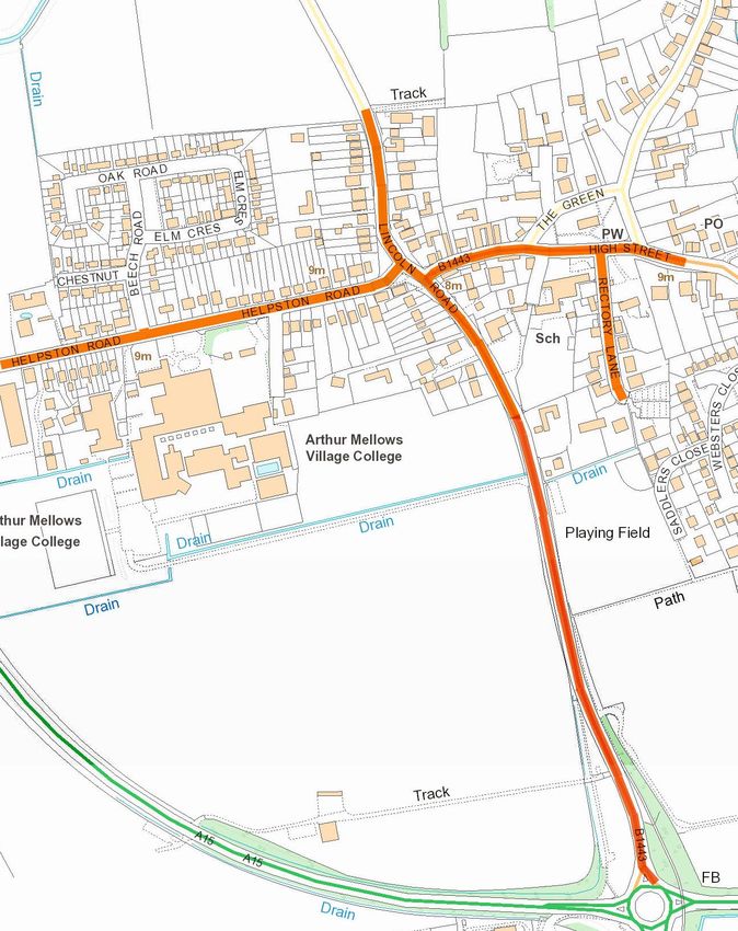
1. Chairman’s Overview

   Neighbourhood Development Plans result from the Government’s determination
   to ensure that local communities are closely involved in the decisions which affect
   them. The Glinton Neighbourhood Plan (GNP) has been developed to establish a
   vision for the village and to help deliver the local community’s aspirations and
   needs for the plan period 2016 - 2036.
   Unlike the Glinton Village Design Statement 2007 (https://peterborough.gov.uk/
   file/1328607) and Glinton Neighbourhood Investment Plan 2008, upon which it
   builds, the Neighbourhood Development Plan is a statutory document that will be
   incorporated into the Development Plan for Peterborough and will be used by
   Peterborough City Council to determine planning applications. The Plan has
   been produced by residents, with the support of the Parish Council, using the
   views of the residents of Glinton.
   The Working Group has consulted and listened to the community and local
   organisations on a wide range of issues that will influence the well-being,
   sustainability and long-term preservation of our rural community. Every effort has
   been made to ensure that the views and policies contained in this document
   reflect those of Glinton residents, particularly the responses received from 35.8%
   of dwellings to the October 2016 Glinton Village Neighbourhood Plan – Village
   Questionnaire which has formed the main evidence on which this document is
   based.
   The Parish Council would like to thank the current and past members of the
   Working Group and pay tribute to their work since September 2013. The Parish
   Council is also grateful for the help and the engagement of many others in the
   village without which it would not have been possible to produce this
   Neighbourhood Plan.

Gerry Kirt

                           Glinton Neighbourhood Plan - 1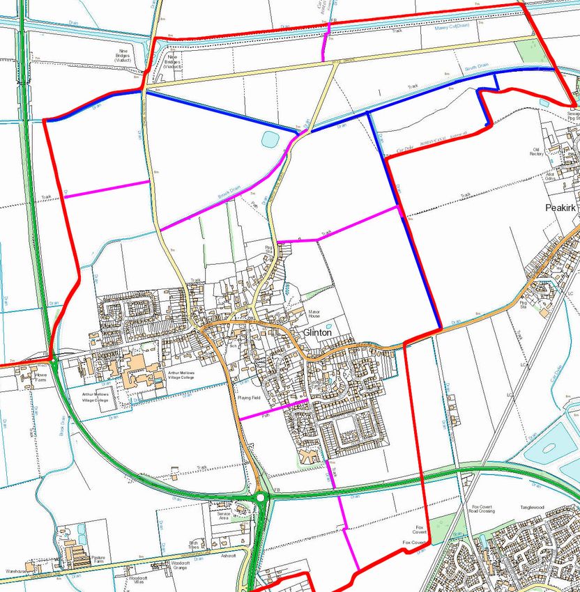
2. Introduction

  2.1. Neighbourhood planning is a central government initiative introduced by the
  Localism Act 2011 and recognised in the National Planning Policy Framework
  (NPPF) in March 2012. The aim of the legislation is to empower local
  communities to use the planning system to promote appropriate and sustainable
  development in their area. Neighbourhood Development Plans (NDPs) must be in
  general conformity with the strategic policies of the Development Plan and have
  regard to national policy and advice.
  2.2. Glinton Parish Council, as the qualifying body, involved the community and
  jointly established the Glinton Neighbourhood Planning Group (GNPG). This
  group comprised of village residents and Parish Councillors to oversee the project
  and make recommendations on the content of the GNP.
  2.3. Neighbourhood plans are to be shaped by and produced for the local
  community. The role of the Working Group was to act as facilitators in enabling
  local residents, businesses and community groups to determine the focus of their
  GNP and devise policies to tackle local issues.
  2.4. The GNP must be in general conformity with the strategic policies of
  Peterborough City Council’s Local Plan. The GNP covers the period 2016 - 2036.
  This period has been chosen to coincide with the new Peterborough Local Plan
  which is due for adoption in early 2019.
  2.5. The plan includes references and extracts from several statutory documents,
  such as HSE’S Land Use Planning Methodology. This is to remind developers and
  Peterborough City Council planners of its existence and the requirement to
  incorporate its recommendations within all relevant applications.
Status of the GNP
  2.6. Once adopted, the GNP will form part of the statutory Development Plan for
  Peterborough. It will be used to determine applications in accordance with
  Planning and Compulsory Purchase Act 2004 Section 38 (6) in that the
  determination of planning applications ‘must be made in accordance with the
  Plan unless material considerations indicate otherwise’.
Developing the GNP
  2.7.The GNP has been prepared for the community by the community. This
  document is the product of a process of community events and consultation with
  residents, stakeholders, statutory bodies and landowners. Through this process
  the Working Party has interpreted the requirements, confirmed their validity at
  each stage of the process and produced the Plan.
  2.8. The table below provides a brief outline of the community consultation events
  held that fed into the GNP Questionnaire, the results of which form the basis for
  the GNP:

                          Glinton Neighbourhood Plan - 2
Event              Brief Description                           Venue                     Date

Launch Event       Overview of objectives. Distribution of     Glinton Village Hall      25/1/2014
                   questionnaire to attendees and the all                                26/1/2014
                   properties in the village
Primary School     NPD roadshow to publicise the aims          Primary School            5/7/ 2014
Fete               and objectives of the plan.
Horticultural      NPD roadshow to publicise the aims          AMVC                      20/9/2014
Society Show       and objectives of the plan.
School Bazaar      NPD roadshow to publicise the aims          Primary School            5/12/2014
                   and objectives of the plan.
AMVC Open Day NPD roadshow to publicise the aims               AMVC                      July 2015
              and objectives of the plan.
Primary School     NPD roadshow to publicise the aims          Primary School            15/7/2015
Open Evening       and objectives of the plan.
Letter to          Advising them of the GNP and                                          July 2015
Landowners and     requesting feedback on what the
Estate Agents      working party should consider. No
                   feedback received.
Update             Overview of GNP, associated events          Village Tribune           January
                   and progress                                (distributed to all       2014
                                                               households and online),   onwards
                                                               Parish Council Minutes
                                                               (Glinton noticeboards
                                                               and online) and
                                                               dedicated website and
                                                               Facebook page.
GNP                Questionnaire distributed to all                                      Sept 2016
Questionnaire      dwellings, businesses and landowners
GNP Interim        Results of the questionnaire distributed                              July/Aug
Consultation       to all dwellings, businesses and                                      2017
Document           landowners for feedback.
Public Meeting     Planned Larkfleet Housing Development Glinton Village Hall            27/10/17
                   – results of the questionnaire were
                   discussed. 99% of attendees supported
                   the results and recommended the
                   development should be rejected.
Public Meeting     Planned Larkfleet Housing Development       Glinton Village Hall      16/1/18
prior to Glinton   – results of the questionnaire were
Parish Council     discussed. The Council recommended
Meeting            the development should be rejected.
Strategic          PCC undertook a screening exercise to                                 March
Environmental      determine whether the GNP required a                                  2019
Assessment &       full Strategic Environmental Assessment
Habitats           (SEA) and/or Habitats Regulation
Regulation         Assessment (HRA). It found GNP
Assessment         satisfied the basic conditions and was in
                   general conformity with the strategic
                   polices contained in the development
                   plan (the Local Plan) for the area.

                                Glinton Neighbourhood Plan - 3
Draft GNP      Glinton Parish Council formally adopted        Glinton Village Hall      16 April
               the draft GNP.                                                           2019
Public         Statutory Consultation. Notice of the          Notice of the             13/7/2019
Consultation   consultation distributed via leaflets to all   consultation              To
               relevant statutory bodies, landowners          also appeared in the      14/9/2019
               and residents.                                 Village Tribune. Ballot
                                                              boxes were located in
                                                              the doctors surgery,
                                                              chemist and local shop/
                                                              Post Office.
Final GNP      Glinton Parish Council formally adopted        Glinton Village Hall      January
               the GNP.                                                                 2020

  2.8. GNPG having developed an overall understanding of views through public
  consultation events, discussions with landowners and a postcard survey of all
  residents, produced a village questionnaire which was distributed to all dwellings.
  The 35.8% response forms the basis for this plan.
  2.9. The plan was originally developed to cover a timescale between its eventual
  adoption and 2030. After taking advice from PCC, it was decided to reflect the
  same duration of Peterborough City Council’s emerging Local Plan 2016 - 2036.

                             Glinton Neighbourhood Plan - 4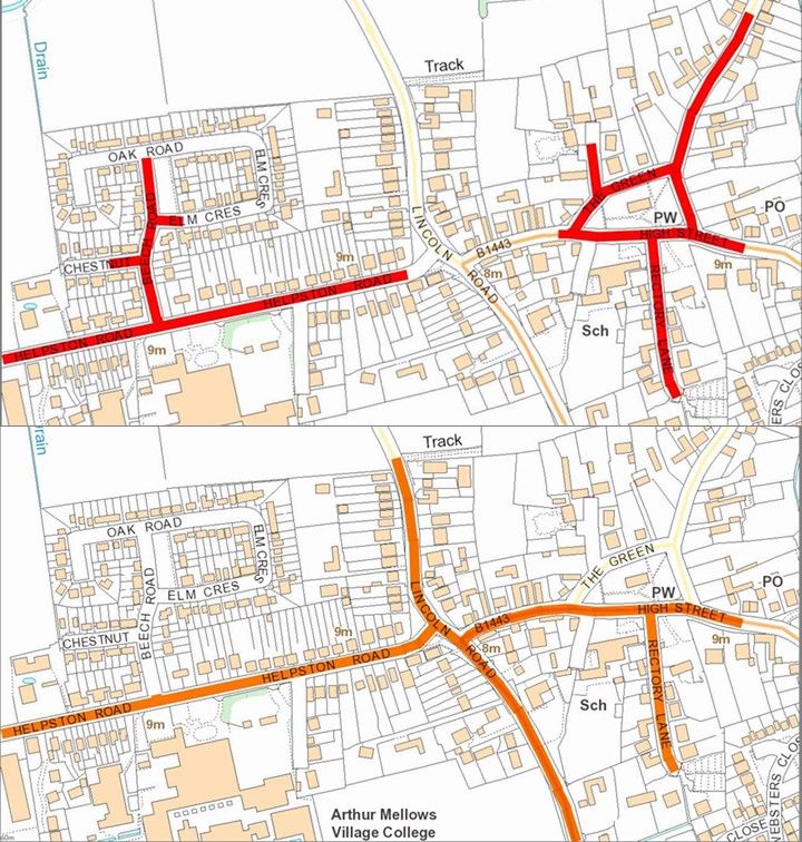
Map 1: Parish Boundary of Glinton (shown in red)

                                 Glinton Neighbourhood Plan - 5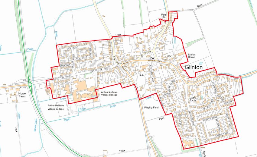
3. Background to the Parish

  3.1. Glinton is a rural ‘Fen Edge’ village of c.674 houses (in 2018) with c.692 in
  the wider Glinton Parish area, situated to the north of Peterborough,
  Cambridgeshire, and is only a few metres above sea level. The landscape is flat,
  intersected by drainage dykes, and is characterised by expansive views over
  arable farmland although there are also some small areas of woodland. Within
  the village envelope there is a conservation area containing many historic
  buildings, and both within and outside of this area there are historic landscape
  features and areas of archaeological interest. The nearest city is Peterborough
  whose centre is located 6 miles from Glinton and roughly 50 minutes due north
  from London by train.
  3.2. A number of infill sites and some agricultural buildings within the village
  envelope have been subject to residential development. All but one of Glinton’s 5
  public houses have been converted into residential dwellings with the former
  Crown pub used as a dwelling and the Happy Faces mother and toddler nursery
  school.
  3.3. The south of the Parish is characterised by major infrastructure (National
  Grid’s gas compressor station and Network Rail’s east coast line) and light
  industrial businesses off Waterworks Lane.
Socio‐Economic Profile
  3.4. Almost a quarter of the population is aged between 45 and 59 and over half
  are over 45. This has implications for the future demographic of the Parish as in
  ten years a large proportion of residents will be of retirement age.
  3.5. The Parish is characterised by a significant number of full‐time employed
  people in white collar occupations and exceptionally low levels of unemployment.
  The Census indicates that 74% (596) of the working village population travel to
  work by van or car and relatively small numbers of people travel using the train,
  bus, bicycle or on foot. A small number (6.8%) of residents work from home.
  3.6. Housing provision within the Parish largely consists of detached houses or
  bungalows (56.2%) and semi-detached dwellings (39.6%) with a high instance of
  larger homes. Census data shows that whilst houses are larger, the number of
  people living in each home is 2.56 which is above the English national average of
  2.4. Most of the properties are owner occupied (86.1%). The percentage of
  socially rented households within the area is 7.7% and those privately rented is
  5.2%. (All data taken from the 2011 census profile for Glinton).
Landscape
  3.7. Glinton rises only a few metres above sea level on a gravel island and the
  surrounding landscape is characterised by arable farmland and intersected by
  drainage dykes and smaller drains. The fields immediately to the north and east
  of Glinton retain hedgerows and tree-lines which are responsible for a more
  enclosed feel to the landscape and an attractive visual impression. Several

                           Glinton Neighbourhood Plan - 6
hedgerows within the
  conservation area (see PCC -
  Glinton Conservation Area -
  Appendix 1.5 trees and hedges)
  have been identified as
  important (including those to the
  north of the church, Balcony
  House, and 12 High Street), and
  there are a number of mature
  trees, veteran trees and wide
  verges which help to give
  Glinton a distinctive character
  and define it as a country village
  (see Supplemental Planning
  Document https://drive.google.com/file/d/
  1fKGtykUxqbgY_EM27jTcLmix4nHC8Wjb/view ).
History and Conservation
  3.8. The Parish contains many historically important features including a number
  of listed buildings, archaeological and other historic assets (see Appendix 3 -
  Locations of Historic Significance). The centre of Glinton is a designated
                                                  Conservation Areas due to its
                                                  history and architectural character.
                                                  The village has a distinctive
                                                  character formed over time in
                                                  response to its landscape setting,
                                                  history and ownership.
                                                 Services
                                                 3.9. The village and its hinterland
                                                 are served by a Parish Church,
                                                 doctors’ surgery, three care homes,
                                                 a public house, the Peakirk cum
                                                 Glinton Primary School and Arthur
                                                 Mellows Village College. There is a
                                                 chemist, a combined Post Office
                                                 and local supermarket, several small
  to medium businesses, and several working farms. A large gas compressor
  station is located on the western border of the Parish. Clare Lodge, a national
  provider of secure accommodation, welfare only placements, and the only all
  female unit in the UK, operates on a site on the edge of the village envelope.
  3.10. Glinton is well served with public transport connections to Peterborough,
  Stamford and local villages during the day and early evening.

                           Glinton Neighbourhood Plan - 7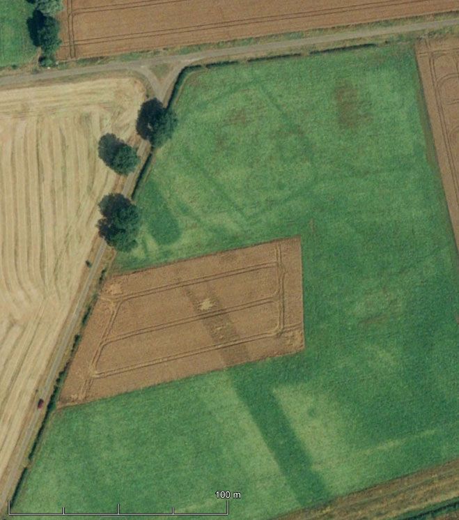
4. Objectives

  4.1. Glinton Neighbourhood Plan has been developed by volunteers from the
  village based on feedback from the community through the results of the Glinton
  Neighbourhood Plan Questionnaire 2016. The key objectives reflecting the
  overriding views of the community are set out below:
  Climate Change
    Glinton’s policies have been developed to underpin the government initiative to
    mitigate the effects of climate change. Glinton Neighbourhood Plan is in
    compliance with the Peterborough Local Plan policies LP1 and LP 31 (see also
    Appendix 2).
  Development
    The GNP will protect the village from misplaced development and ensure that
    any development is sympathetic to, and improves, the look and feel of the
    village. It will encourage the construction of new houses that meet the
    identified requirements of Glinton residents as based on feedback from the
    community through the Glinton Village Plan Questionnaire 2016.
  Natural Environment
    The community has made it clear that they wish to make Glinton a more
    wildlife-friendly village, and the GNP aims to support this aspiration. Mature
    trees, hedges and green spaces are of particular importance to the appearance
    and character of the village, and these landscape features greatly contribute to
    the quality of village life. The GNP seeks to protect and enhance the natural
    environment of Glinton and the wildlife therein.
    The GNP seeks to secure the protection of existing mature and veteran trees
    and the delivery of new trees in support of the Peterborough Environment
    Capital Trust ambition to plant 180,000 trees by 2030 and it also aims to
    establish a nature recovery area (or areas) within the parish boundary.
  Services and Facilities
    The GNP will encourage the creation of an attractive and usable public realm,
    preserve existing services (including schools and church) and support the
    establishment of new accessible local services and community enterprises,
    which meet the needs of Glinton.
  Cultural Landscape
    The GNP will preserve and enhance local landscape features including, but not
    limited to, the Conservation Area, views towards St Benedict church and views
    to surrounding villages.
  Traffic and Transport
    The GNP will encourage sympathetically designed vehicle parking whilst

                          Glinton Neighbourhood Plan - 8
creating an attractive, safe and usable public realm for pedestrians and cyclists.
Sustainable Access
Developments will not be supported that adversely affect the number,
maintenance and quality of sustainable routes for bus, foot and cycle transport
within the Parish and between Glinton and the surrounding villages. This also
includes safe routes to schools, shops and services. This will be achieved
through cooperation with relevant Peterborough City Council departments, e.g.
Highways Department and commercial organisations such as Delaine buses.
Sustainable Economic Development
The GNP supports increased economic activity appropriate to the rural nature
of the Parish by encouraging small scale opportunities in sustainable locations
and working from home conversions.
Glinton Neighbourhood Plan - 95. Policies
The policies are based on evidence supporting the Peterborough Local Plan,
developed by the GNPG and feedback obtained from the Glinton Neighbourhood
Plan Questionnaire 2016. Some of the key findings of the GNPQ can be found in
Appendix 5.
GNP1 GNP8
Housing Growth
11 Important
26
Views
GNP2 GNP9
Location of
13 Drainage
28
New and Flood
Development Risk
GNP3 GNP10
Design
16 Traffic
29
GNP4 GNP11
Infrastructure
19 Footpaths
31
Development and
Cycleways
GNP5 GNP12
Local Green
20 Growing
33
Space the Local
Economy
GNP6 GNP13
The Natural
23 Clare
34
Environment Lodge
GNP7 GNP14
Car Parking
25 Recreation
35
Ground
and Village
Hall
Glinton Neighbourhood Plan - 10Housing Growth
There are 674 dwellings in Glinton village (in 2018), and there are a
total of 692 dwellings in the wider Parish area (in 2018). This Parish
figure has risen steadily since 2001 when it stood at 653 dwellings
and then 680 dwellings in 2011, according to Census information. It
is important to maintain some steady growth in Glinton to ensure that it remains a
vibrant place to live, and that our valued services and facilities continue to thrive
but are not overwhelmed.
According to the 2011 Census there was a higher proportion of 4 and 5 bed
properties in Glinton Parish than in the wider Peterborough area. This is shown in
Table below:
Glinton Parish Peterborough
Bedrooms
No. % No. %
All dwellings 671 100% 74,023 100%
No bedrooms 0 0% 195 0%
1 bedroom 11 2% 8,527 12%
2 bedrooms 84 13% 17,979 24%
3 bedrooms 326 49% 32,433 44%
4 or more bedrooms 250 37% 14,889 20%
Whilst the wider Peterborough area might reasonably be expected to have a
lower proportion of larger houses due to the urban area, the Census information
for the Peterborough area is also available broken down by whether it is “urban”
or “rural”. This information shows that for rural parts of the Peterborough Local
Authority area, only 29% of dwellings had 4 or more bedrooms, still substantially
lower than that for Glinton.
This tendency towards larger homes has also been exaggerated by new
dwellings being built and planning permissions issued since the Census in 2011.
There have been 24 dwellings (net) approved, under construction or built in
Glinton since 2011. Taking into account the size of existing properties that have
been or are about to be demolished as part of proposals, 71% (17 dwellings) are
4 bedroom or larger, 8% (2 dwellings) are 3 bedroom, 17% (4 dwellings) are 2
bedroom and 4% (1 dwelling) are 1 bedroom. Furthermore, one of the 2
bedroom properties and two of the 3 bedroom properties were provided as
affordable housing, reducing the number of smaller homes available on the
general housing market.
It is important that a variety of housing size is provided by new development in
order to offer the opportunity for upsizing, downsizing and to ensure that
development is not only provided for people seeking large executive homes. This
is important to ensure a balanced community remains in the village and that
residents are not priced out of the village.
Glinton Neighbourhood Plan - 11It is also important that development takes place within the village envelope as
defined in the Peterborough Local Plan. This helps to ensure that the rural village
setting is maintained and that the village retains its strong nucleus with new
homes being located in proximity to the services and facilities.
Through consultation with the community, it is clear that there is support for some
limited development within the village envelope, provided that it will not negatively
impact on local character and provided it will not, in isolation or in conjunction
with other development, overwhelm infrastructure. However, it is also clear that
any growth must be carefully managed throughout the plan period. This plan
therefore proposes a growth level of 5% in dwelling numbers in the village
envelope across the plan period which allows for the development of 34 dwellings
to 2036. This number is considered to be appropriate in terms of delivering
organic growth over the next 15 years. It also reflects the general growth of the
village in recent years and is consistent with the requirements of the Peterborough
Local Plan.
Policy GNP1: Housing Growth
The housing growth will be managed across the plan period to ensure that Glinton
grows steadily and sustainably. This growth will amount to around 5% in dwelling
numbers as calculated at 1 April 2018, through the development of up to 34 dwellings
by 2036 *.
If a development proposal together with other dwellings built after 1 April 2018 or with
a live permission would result in the total number of dwellings exceeding this 34
dwelling growth level, it must be accompanied by evidence of clear local community
support, or the written support of Glinton Parish Council, for the proposed scheme,
demonstrated through a thorough and proportionate pre-application community
consultation exercise.
Development proposals which deliver new homes should contribute positively to
providing a mix of housing types, styles and sizes, where this is appropriate for the site
context. Development proposals for 5 or more dwellings should incorporate some
smaller homes of 3 or fewer bedrooms where this would not harm the local character.
Proposals that include dwellings of 3 or fewer bedrooms, starter or other affordable
homes, bungalows, or for older people suitable for independent living, will be viewed
favourably where they are consistent with the Development Plan.
* Dwellings with permission but not complete at 1 April 2018 are included in this
growth level.
Glinton Neighbourhood Plan - 12Location of New Development
One of Glinton’s most valued assets is its village character including
the surrounding countryside. There are a number of neighbouring
villages within a short distance of Glinton, with Peakirk being the
closest at 590m followed by Etton at 660m, but it is the
Peterborough urban area that is the nearest built area located only 500m from the
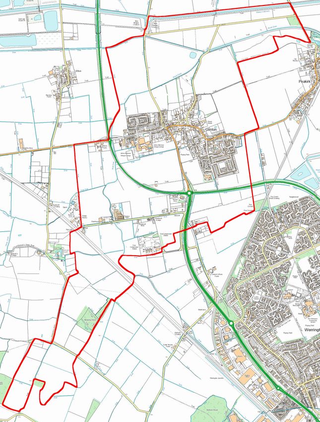
Village Envelope - shown in Map 2.
Map 2: Glinton Village Envelope (shown in red)
This proximity to neighbouring
settlements makes these gaps
particularly sensitive and ensuring that
they are retained, both physically and
visually, is a core objective of this plan
as they are essential to the distinct
character and identity of Glinton.
Another important attribute of Glinton
is its strong nucleated built form. It is
Looking West towards Helpston
a compact village with its facilities
being located near to all households
and the village is approximately 1.4km at its widest point.
Glinton is a rural ‘Fen Edge’ village containing a Norman Church and a large
number of stone built dwellings. The landscape is characterised by broad views
over arable farmland towards local villages including Peakirk, Etton and
Northborough. The consultation that has been undertaken highlights that the
Glinton Neighbourhood Plan - 13Looking North towards Northborough Looking South towards Werrington
community highly values its heritage and its rural setting.
Development proposals in Glinton
must respect these important
characteristics and should contribute
positively to them through their design
and location, placing context at the
heart of the proposal.
Glinton also has a number of major
hazard sites and major accident
Looking East towards Peakirk
hazard pipelines which affect a
substantial area of the Parish. These
hazards are subject to the Health and Safety Executive’s Land Use Planning
Methodology to ensure that they are consulted on proposals that are located
within the ‘consultation zones’ of these hazards.
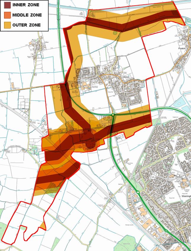
Maps 3 Hazard Zones correct as January 2018 – for further and current clarification contact should be made
with the HSE.
The current extent of these consultation zones is shown in map 3 above.
Glinton Neighbourhood Plan - 14Given the coverage of these zones within the Parish it is vital to ensure that
adequate consultation is undertaken in order to ensure that current or future
residents are not put in any danger.
Any work in the vicinity of gas pipelines must be compliant with - specification for
safe working in the city of National Grid high pressure gas pipelines and
associated installations- requirements for third parties.
Two examples of In-fill development in Glinton. Dovecote on the left and Farhtingstones on the right
Policy GNP2: Location of New Development
Development proposals within the village envelope, as shown in Map 1, will be
supported in principle, where they satisfy the policies of the Development Plan.
Outside of the village envelope land is defined as countryside. Development in the
countryside will be restricted to that which is:
2.1 demonstrably essential to the effective operation of local agriculture,
horticulture, forestry, outdoor recreation and access to natural green space,
transport or utility services; or
2.2 residential development which satisfies the ‘exception’ test set out in policy LP8
of the Peterborough Local Plan; or
2.3 development in accordance with Policy LP11 of the Peterborough Local Plan;
or
2.4 minerals or waste development in accordance with the Minerals and Waste
Development Plan Documents for the area.
Development proposals outside of the village envelope should not result, either in
isolation or in conjunction with other developments, in the physical or visual
coalescence of Glinton with any neighbouring settlement.
The Health and Safety Executive should be consulted where a development proposal
is located within a consultation zone for a hazardous installation or pipeline and this
would trigger the consultation in accordance with the HSE’S Land Use Planning
Methodology guidance. Proposals will not be supported where the HSE advise
against a proposal following consultation.
Glinton Neighbourhood Plan - 15Design
Good design is paramount to achieving sustainable development in
Glinton as it is elsewhere. This includes a number of key
components including the delivery of low carbon buildings, the
reflection of local character and careful consideration of the
immediate surroundings, the materials used and the boundary treatments
incorporated in the scheme.
Poppyfields’ gated development on Lincoln Road Glinton - see policy GNP3 - 3.5
It is vital that existing village characteristics are taken into account in designing
development proposals. Peterborough City Council’s Design and Development in
Selected Villages Supplemental Planning Document (SPD) provides a useful set of
‘Principles of Development’ for all villages and limestone villages and a set of
Glinton-specific ‘Design Guidelines’ which should be used to inform the design
process. All development proposals will be expected to demonstrate how these
principles and guidelines have been considered and factored into the proposals
on plans and other evidence submitted in support of the application, wherever
they are relevant to the proposal. If a proposal does not satisfy any of these
criteria, evidence will be required to justify the departure.
This plan seeks to ensure that all proposals coming forward in Glinton will exhibit
high quality design appropriate for the site context that will help to limit the impact
on the environment whilst protecting the important attributes of the local
character.
With the ever increasing and urgent need to tackle climate change, the recent
Glinton Neighbourhood Plan - 16Development of two new homes on the Lincoln Road
declaration of a climate emergency by the local authority and a lack of central
government legislation, developers and builders should be encouraged to be
proactive in adhering to a ‘greener’ set of rules on housing design. Local planning
bodies should be boldly stating what is now expected from responsible building
and setting strong targets to developers.
Whilst government policy limits the requirements that can be placed upon
developments in terms of renewable technology and carbon reduction, the
neighbourhood plan challenges applicants to seek to achieve higher standards
wherever possible and appropriate for the context.
Builders and developers are encouraged to submit Applications that adhere to
the:
• Ministry of Housing - Communities and Local Government - The Future Home
Standards
• Ministry of Housing - National Design Guide
Other welcome standards include the:
• Building for Life 12 scheme
• The Code for Sustainable Homes
See Appendix 7 for the website links to the above documents.
Glinton Neighbourhood Plan - 17Policy GNP3: Design
Development proposals must deliver high quality design through:
3.1 Delivering an amount and scale of development that is appropriate for the site,
taking into account the site size and shape, making the best use of the site given its
context;
3.2 Responding positively to key features on the site such as trees and other natural
environmental features, topography, and buildings and retaining them as part of the
scheme wherever possible;
3.3 Responding positively to important local characteristics as detailed in the Design
and Development in Selected Villages SPD;
3.4 Avoiding blank frontages and introducing visual interest from the surrounding area
through the overall design, orientation and position of buildings, architectural details,
landscaping and materials, particularly when viewed from publicly accessible areas;
3.5 Socially, physically and visually integrating the proposal with the surrounding
community, avoiding features that would cause separation such as a gated
community;
3.6 Providing a mix of dwelling styles and sizes where appropriate;
3.7 Ensuring the height of new development is reflective of the low (two storeys or
fewer) character of present development in the village;
3.8 Including an extensive green landscaping scheme that provides habitat, roosting
and foraging for wildlife and links well with surrounding green infrastructure;
3.9 Introduction of well-designed boundary treatments, suited to the village character;
3.10 Providing adequate amenity space for future occupiers of the proposals;
3.11 Not resulting in unacceptable impacts on the amenity of occupants of neighbouring
or nearby properties, including, but not limited to, through light or noise pollution;
3.12 Providing buildings and spaces that are accessible, inclusive and safe; and
3.13 Using high quality sustainable materials throughout the scheme.
3.14 Incorporating dual, electric car charging points of minimum 7.2kW power.
Proposals that exhibit substandard design quality, particularly when considered against
these requirements, will not be supported.
Plans and supporting statements submitted with planning applications should make clear
how decisions on the design of the proposal were arrived at and why they are appropriate
for the context of the site.
Development that exhibits outstanding or innovative design will be supported in principle,
where this is appropriate for the context of the site.
Proposals that seek to incorporate renewable or low carbon technologies beyond that
required by building regulations will be viewed favourably. Opportunities should be taken
wherever possible and appropriate for the site context to maximise passive solar gain and
minimise the use of energy and water.
Proposals that contain elements producing unjustifiable external light pollution that are
unsuitable for a rural environment should strongly be discouraged e.g. 24-hour security
lighting, non-PIR operated lighting and non-timed street lighting. See Appendix 8.
Glinton Neighbourhood Plan - 18Infrastructure Development
There have been a number of infrastructure-related developments in
Glinton Parish in recent years. The Parish Council has engaged
positively with the infrastructure providers on these developments to
help ensure that they achieve the necessary goals and that any
impacts are appropriately managed and, where necessary, mitigated. This
dialogue is valued and should continue with any future proposals.
National Grid gas compressor station
Policy GNP4: Infrastructure Development
Where development is proposed for infrastructure purposes, Glinton Parish Council
should be engaged at the earliest possible opportunity of the design process, to help
ensure any impacts are mitigated or minimised where possible.
Glinton Neighbourhood Plan - 19Local Green Space
Glinton is a rural village surrounded by farmland. Although situated
in a green environment, very few green spaces exist within the village
envelope and those that do are therefore highly valued by residents.
One area is located outside the village envelope which is of historic
significance. All spaces shown on maps 4, 5 and 6 should be protected against
future development.
The green space in the middle of the village
bordered by the Bluebell public house,
medieval parish church, chemist, village
pump and memorial bench, and Peakirk
cum Glinton C of E school is a picturesque
area that defines the visual character of
Glinton. The space was originally a pond
that supplied the village fire engine which
was housed inside the building that is now
occupied by the chemist.
Play parks and green areas provide oases
within two of Glinton’s housing
Map 4. The green space in the middle of the
village bordered by the Bluebell public house, developments. Of particular value to the
medieval Parish Church, chemist, village pump community are those located between the
and memorial bench, and Peakirk cum Glinton Willows and Clarendon Way and the space
C of E Primary school.
in Scott’s Road.
Map 5. The space in Scott’s Road Map 6. Play parks and green areas between
the Willows and Clarendon Way
The grassed triangle to the west of the A15/Old Lincoln Road roundabout is
populated with a large number of immature trees and provides a significant green
gateway into the village.
Glinton Neighbourhood Plan - 20Glinton is home to some fascinating and regionally significant archaeology. This is
particularly prevalent in the ridge and furrow fields to the north of the village, east
of Lincoln Road where there are well preserved remains of medieval and post
medieval ridge and furrow.
Professor Stephen Upex (Professor of
Archaeology at Cambridge University)
provided a view on the archaeology and
historic importance of the site. He concluded
that the fields to the north of Glinton
“…represent some of the last remaining
furlong extents in the entire Welland valley
and possibly the last true medieval
cultivation features within the whole of
Glinton Parish. The origins of Glinton are
ancient; it is certainly referred to in late
Anglo-Saxon charters and there is good
evidence to suggest that it was founded as
a settlement before the conquest of 1066.
Map 7. The Ridge and Furrow Field location Linked to this is the well established details
of ridge and furrow being first developed in
the mid to late Saxon period. Thus the
furlongs under question at Glinton, being fairly close to the centre of the village
and church, would probably date from this early period. An early reference to
‘Brook Drain’ in 1340, where it is called ‘le Brok’, clearly indicates that the land
around and on both sides of the drain were being worked agriculturally and thus
the furlongs under question, which butt onto this drain, by implication, were
certainly there in the mid 14th century.
My own view is that such areas of increasingly scarce ridge and furrow are of
local and regional importance as historical and archaeological markers and ought
to be considered for long term preservation where they can be integrated into
and serve education, heritage, amenity and recreational functions.”
The full assessment by Professor Upex is provided at Appendix 3.
Ridge and Furrow Green Space Public Footpath through Ridge and Furrow Field
At approximately 7.7 hectares, the fields are local in character and are well
contained by surrounding mature hedgerows containing hedgerow trees. Given
the importance of these fields, this plan seeks to protect them from development
that would remove or reduce their historic value. They are a unique survivor of
Glinton Neighbourhood Plan - 21ancient field systems that clearly illustrate the early development of Glinton. The
fields are immediately adjacent to the village and are in close proximity to the
community who use the public right of way running across the northern border for
recreational purposes. These fields satisfy the criteria set out in the NPPF for
designation as Local Green Space.
A green space at the centre of the village with the Bluebell public house in the background
Policy GNP5: Local Green Space
Development proposals on a Local Green Space will not be permitted other than in
exceptional circumstances, in line with national policy. The green spaces are:
5.1. The green space in the middle of the village bordered by the Bluebell public
house, medieval parish church, chemist, village pump and memorial bench, and
Peakirk cum Glinton C of E school.
5.2. Play parks and green areas between the Willows and Clarendon Way and the
space in Scott’s Road.
5.3. The Ridge and Furrow fields, east of Lincoln Road.
Glinton Neighbourhood Plan - 22The Natural Environment
The community places significant value on the natural environment in
the Parish, including the landscape features, views, and rural
environment of the Parish which are important as a wildlife habitat,
leisure resource, and historic rural setting for the village.
Features such as traditional (living) field
boundaries, field margins and field shapes,
brooks and dykes, trees, tree lines and hedges,
are of value to wildlife and to the shape and
history of the landscape, and it is expected that
they be maintained or enhanced where possible.
Development provides an opportunity to
deliver benefits to the natural environment if
done in a sensitive manner. For example, a
new development at Kingsbrook in
Aylesbury ( Visit https://www.rspb.org.uk/
our-work/conservation/projects/kingsbrook-
housing/ for details) has been constructed
to provide proactive support for wildlife,
incorporating nesting and/or roosting areas,
and habitat and foraging for birds,
invertebrates and small mammals. New
development within the Parish of Glinton
should seek to deliver these improvements,
wherever possible incorporating the
measures implemented at Kingsbrook.
Any harm to wildlife habitats or important environmental features (such as hedges,
trees, fields, field margins and dykes) as a result of development will be resisted.
Applications should be accompanied by a clear assessment of the impacts with
adequate justification for why these impacts are unavoidable along with proposals
for mitigation.
Glinton Neighbourhood Plan - 23Policy GNP6: The Natural Environment
Development proposals should protect existing natural features and deliver
enhancements to the natural environment of Glinton wherever possible by:
6.1 Retaining existing, and delivery of new, natural landscape features including
hedgerows, ponds, pools, brooks, ditches and trees;
6.2 Incorporating nesting boxes and/or roosting sites, and habitat and foraging areas
for wildlife;
6.3 Avoiding the restriction of movement of wildlife through the use of soft landscaping
for boundary treatment, or by providing gaps under fences or in walls; and
6.4 Providing garden areas of an appropriate size, with a landscaping scheme that will
maximise opportunities to create new or extend existing habitats.
Development proposals should, wherever possible, seek to enhance connectivity of
green networks through the inclusion of strong landscaping schemes that include trees,
shrubs, hedgerows, and, for example, green roofs and green walls.
Where the loss of a feature is unavoidable, mitigation may be acceptable through the
introduction of new features that will result in at least a neutral impact on the wildlife.
Ancient woodland, aged and veteran trees, trees protected by Tree Preservation Orders,
and trees in the Conservation Area should be protected and retained as per
the requirements of LP29 (Trees and Woodland) of the Local Plan. Where the loss of such
a higher value tree/ woodland is acceptable, as per LP29, in addition to
the compensatory tree planting requirements set out in LP29, the replacement tree/s
should:
6.5 Be at least 10 years old; and be of the same species as the removed tree/s, unless
there are overriding reasons why this is not appropriate such as being non native
species;
6.6 Where possible dead trunks should be left upright and partially buried; or the
stumps of felled trees left in situ and the dead wood of the felled trees left onsite to
decompose.
Overall a net gain in biodiversity should be achieved, demonstrated by appropriate
evidence prepared by a suitably qualified person on behalf of the applicant.
GNP aspires to create within the parish of Glinton a nature recovery area including
woodland.
Glinton Neighbourhood Plan - 24Car Parking
Parking problems within
Glinton impact on the quality
of life of its residents, creating
unpleasant and sometimes
unsafe scenarios where vehicles have to
weave in and out of rows of parked cars.
Insufficient street parking represents a
safety issue within the village, particularly at
school pick and drop off times.
Whilst opportunities to address existing on-
street parking issues are limited, it is
important to ensure that any new
development does not exacerbate the
problems.
Policy GNP7: Car Parking
Development proposals will be required to meet the parking standards in the up to
date Local Plan as a minimum and proposals which exceed this minimum will, in
principle, be welcomed, provided this does not give rise to a poor quality design
overall.
In proposals incorporating residential development, vehicle parking will usually be
required to be provided on-plot. Any on-street parking will require justification for why
it is the most appropriate design solution for the proposal, including a clear
demonstration of how the spaces are suitably located near to an entry point of each
dwelling. Any on-street parking should be included in initial designs to ensure that
any visual impact is minimised and to ensure that movement for vehicles and
pedestrians will not be restricted.
Proposals that are likely to result in unplanned on-street parking will not be supported.
Proposals will be expected to include facilities for electric plug-in vehicles with an
adequate number of plugs in a convenient location to charge vehicles in each
allocated car space. Information supporting the application should demonstrate the
suitability of the number and location of these charging points in relation to the
parking spaces to be provided.
Glinton Neighbourhood Plan - 25Important Views
Glinton contains a number of views that are particularly striking,
important for local character and valued by the community. The
views of open countryside across a clear separation of Glinton from
its neighbouring communities are vital to the enjoyment of rural
footpaths and the rural character of Glinton.
Map 8. Views shown by arrows 1, 2, 3 & 4 are indicative and illustrated in the photographs below
Of particular importance are the views around the Parish towards St Benedict
Parish Church. Not only is the church of local importance as a landmark, but it is
also recognised as one of Britain’s finest needle spires and has important historic
links to the poet John Clare.
View 1: South across the ridge and furrow field View 2: East from Helpston Road
View 3: South west from North Fen Road View 4: South east from the A15 bypass
Glinton Neighbourhood Plan - 26There are views of St Benedict Parish Church from a multitude of locations across
the Parish and some are shown above.
Policy GNP8: Important Views
Development proposals should not obstruct or detract from any view of St Benedict
Parish Church from any public location. Any proposal that has potential to impact on
a view should consider the views in the design process and be accompanied by
supporting information to demonstrate why the proposal will not have a negative
impact on the view.
Glinton Neighbourhood Plan - 27Drainage and Flood Risk
Glinton’s foul and surface water systems have been operating at full
capacity for many years. Recent increases in the number of new
properties, roads and driveways feeding into the infrastructure have
caused regular blockages and flooding. Examples include surface
drain flooding on Welmore Road, blockages in the foul systems on High Street
and St Benedicts Close, and the requirement to regularly drain the sewerage
buffer tank situated on North Fen Road.
The pressures of further development on the
existing surface and foul water systems
means any new development requires
careful consideration and planning.
Measures to both slow and to naturally
clean up surface water, prior to release into
local piping or water courses, are
imperative. Although all major applications
containing 10+ dwellings - are required to Websters Farm - 2014
have Sustainable Drainage Systems SuDs),
all developments need to be considered in
respect of their incremental impact on the total infrastructure of the village
During times of high rainfall Glinton’s water
courses rapidly reach capacity, particularly
Brook Drain, Maxey Cut and South Drain; and
field drainage along North Fen Road and
Lincoln Road, which make them less capable
of absorbing additional run off from new
development.
A sustainable growth strategy is required to
enable the utilisation of existing water handling
schemes and avoid the need to install new
Welmore Road - 2014
systems wherever possible. Glinton sits
between 7 and 11m above sea level which
demands full attention to the policies given below.
Policy GNP9: Drainage and Flood Risk
Development proposals should be in accordance with Local Plan Policy LP32 which
relates to flooding and drainage, or a subsequent replacement policy. Adequate
information must be provided in support of development proposals to clearly
demonstrate that there is an adequate supply of potable water; and foul water and
drainage water will not have negative consequences to existing systems servicing the
village of Glinton.
Glinton Neighbourhood Plan - 28Traffic
The A15 Glinton bypass (single carriage way) was constructed to the
West and South of Glinton in the 1980s. Its purpose was to relieve
the village of increasingly heavy through traffic, and it has largely
achieved that, although village roads
do become very busy at the start and
finish of the school day when many
school buses and cars have to thread
their way through the traffic calming
scheme and narrow access roads,
taking students from or to
surrounding villages.
Following the opening of the A15
Glinton bypass, the former A15
The busy school-time junction where a large number of through the village was downgraded
school buses wait to join the main Lincoln Road to a local access road, but it is still
known as Lincoln Road. To the south
of the village it links to a roundabout on the A15
Glinton bypass. This roundabout provides the
principal route to Peterborough city centre and
directly onto the Peterborough parkway system that
gives easy access to Peterborough industry, and all
Glinton is served well by the
Delaine Bus Company
arterial routes to the
North, South, East and
Map 9: Areas of parking congestion (red) West.
North out of Glinton, the
Lincoln road links to the village of Northborough, and then to the Deepings.
Market Deeping is a small Lincolnshire market town with an expanding range of
facilities and housing. Further north into Lincolnshire is the fast expanding town of
Bourne, and to the northwest, the ancient stone town of Stamford.
Maps 9 and 10 show the key locations where traffic and parking cause problems
in Glinton village.
Glinton Neighbourhood Plan - 29Map 10: Areas of traffic congestion
(orange)
Residents are mostly
happy with local transport
services – the main areas
of contention, as
demonstrated by the
results of the 2016 Glinton
Village Neighbourhood
Plan Questionnaire, were
the issues of speed
control, parking and the
congestion in the village
during the school’s
opening and closing
times.
Typical congestion around the central village during the start and end of the school day
Policy GNP10: Traffic
Proposals to improve bus access for students to Arthur Mellows Village College or the
provision of improved drop off facilities for parents and students will be supported.
Proposals which would increase the number of road access points onto the B1443
(Lincoln Road and High Street) or onto Helpston Road, or that would result in an
increase in vehicle movements in or through the village should demonstrate through
accompanying evidence that any potential impacts of the proposal can be adequately
addressed.
Glinton Neighbourhood Plan - 30Accessibility - Footpaths and Cycleways
Glinton has a good and well used network of footpaths providing for
safe movement for pedestrians across most of the village. It also
enjoys a valued network of footpaths across the countryside in the
Parish.
Map 11: Rights of way - public rights of way (pink) and permissive footpaths (blue). The red line shows the
Parish boundary.
A number of the footpaths in the countryside around Glinton are public rights of
way and others are permissive footpaths and these all link in together to provide a
varied number of circuits for leisure walkers and to travel between neighbouring
villages.
Glinton Neighbourhood Plan - 31Left: Local and popular permissive footpath.
Above: Public footpath linking Glinton with
neighbouring village Peakirk
It is important for the village character and for the benefit of current and future
residents that these footpaths and pedestrian connectivity are maintained and,
wherever possible, enhanced or extended.
Policy GNP11: Footpaths and Cycleways
Development proposals that would obstruct or would result in a significant impact
upon the enjoyment of a public footpath will not normally be allowed. This can
include, but is not limited to, proposals for the creation of new dwellings, new
buildings for commercial use, for a change of use where the proposed use would
materially increase the activity on site, or where the proposed development would
result in an impact through noise, odour, light or other pollution, where this would have
potential to diminish accessibility, connectivity or tranquility of a footpath.
Development proposals that will be clearly visible from a public footpath should be
designed to consider the appearance of the proposal from the footpath and
incorporate green landscaping to reduce any visual impacts.
Development proposals that will enhance or extend an existing public footpath or that
will deliver a new public right of way in a suitable location will be viewed favourably.
Development proposals that are located where there is an opportunity to link two or
more public footpaths or to enhance connectivity through the village should
incorporate this connectivity through the proposal wherever appropriate.
Development proposals should incorporate adequate and safe pedestrian links from
every property within the site to the existing footpath network.
Developers that incorporate existing green footpaths within their developments will be
expected to maintain the accessible width of any existing footpaths while adding
green screening such as hedges to maintain their amenity.
Glinton Neighbourhood Plan - 32Growing the Local Economy
Glinton currently has 2 shops (a chemist and a convenience store/
sub-post office); 1 public house/restaurant (the Bluebell); 1 set of
small business offices (Garrick House); a UPVC window
manufacturing company; and a vehicle bodyshop repair garage.
The local sub-post office and small shop The Bluebell Pub and Restaurant
This neighbourhood plan supports the provision of these businesses and the
opportunities that might arise to grow or for new businesses to form where
appropriate for the site context and for the scale of the proposal.
Policy GNP12: The Local Economy
Development in categories A1 (shops), A2 (financial and professional), A3 (restaurants
and cafes) and B1 whether through the new facilities, conversion or change of use to
these uses, or expansion of existing facilities will be supported provided:
12.1 It will not have an adverse impact on residential amenity and it will not otherwise
compromise the use of neighbouring land;
12.2 It is of an appropriate design and scale appropriate for the site context and
consistent with policy GN3;
12.3 It will not generate significant additional traffic through the villages of Glinton,
Peakirk or Northborough that would result in an unacceptable impact on
highway safety or severe impacts on the road network; and
12.4 It offers safe and suitable access for workers and customers, provides
adequate off-street parking for the scale and use proposed.
Glinton Neighbourhood Plan - 33Clare Lodge
Clare Lodge Secure Children’s Home is owned and operated by
Peterborough City Council. The Home is the only all-female all
welfare secure home in the UK. It provides secure accommodation
for up to 20 young women aged 10 to 17 years. Clare Lodge has a
long history of working with young people and there has been a Home on the
Glinton site since 1978. The Home specialises in offering services to young
women at risk as a result of self-harm, sexual exploitation, abuse, emotional
difficulties, mental health issues and behavioural issues. It provides Care,
Education and Health services on site.
Due to the nature of the Home and the young people it works with, security is of
critical importance. Security within the home provides safety and protection for
the young people from potential external threats.
A significant number of young people are placed at Clare Lodge, during high
profile court cases around child sexual exploitation, as a result maintaining privacy
by the use of screening fences and appropriate landscaping is important.
The young people who live in Clare Lodge have needs which cause them to
require emergency services more frequently than those living in residential housing
therefore a clear and easy route for emergency vehicles to access the site is a
requirement for the safe operation of the home.
Clare Lodge currently benefits from a private, secure, access road directly from
the Lincoln Road. This access was built as a result of significant problems
encountered when access was through the village via Welmore Road. This
compromised emergency access and the 24/7 operation of the site caused its
residential neighbours significant noise issues and prevented staff and delivery
vehicles access to the home. This plan seeks to ensure that such conflict is not
reintroduced through development proposals at neighbouring or nearby sites.
Policy GNP13: Clare Lodge
Development proposals should not adversely impact the security, privacy, emergency
and vehicle access at Clare Lodge. Development proposals which are likely to
introduce future conflict with Clare Lodge due to its operational needs will not be
supported.
Glinton Neighbourhood Plan - 34You can also read