2020 EQC RESEARCH AND RESILIENCE UPDATE - Earthquake ...
←
→
Page content transcription
If your browser does not render page correctly, please read the page content below
2020 EQC RESEARCH AND RESILIENCE UPDATE
“Sometimes it does us a power of good to remind
ourselves that we live … where two tectonic plates
meet, in a somewhat lonely stretch of windswept
ocean just above the roaring forties. If you want
drama you’ve come to the right place.”
Sir Geoffrey Palmer

2020 EQC Research and Resilience Update 1
2                     2020 EQC Research and Resilience Update

    OUR RESILIENCE VISION:
    THAT NATURAL HAZARDS
    RESILIENCE BECOMES
    EMBEDDED IN ALL ASPECTS OF
    DECISION MAKING FOR OUR
    HOMES, TOWNS AND CITIES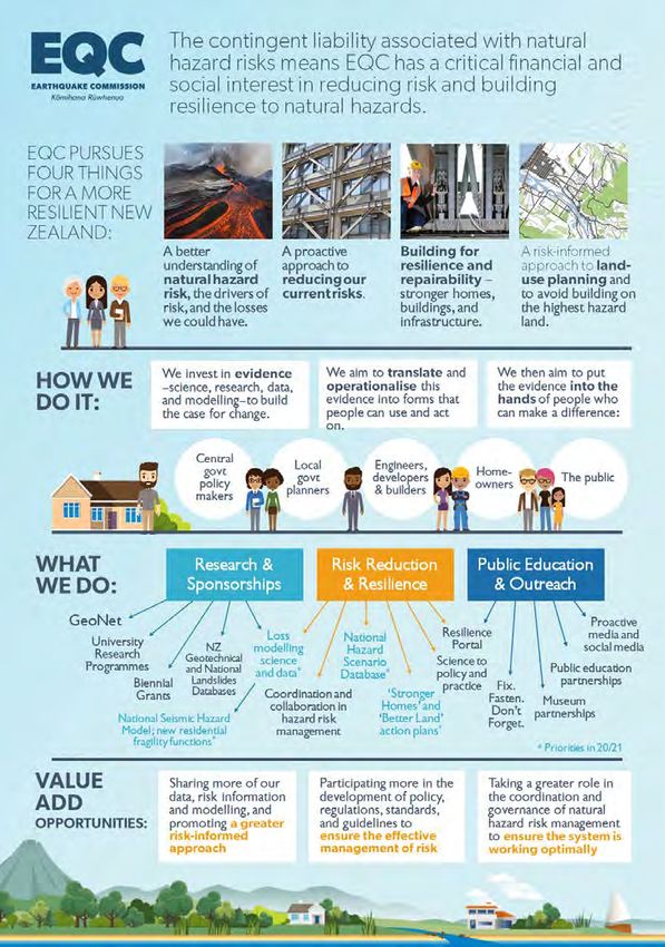
2020 EQC Research and Resilience Update                                                                   3

CONTENTS

Welcome to the the 2020 EQC Research                     Getting the evidence to the right people        34
and Resilience Update                                4
                                                           Bringing science and decision makers
Introduction                                         6     together                                      34

Hazards EQC covers                                   7        DEVORA—All about Auckland volcanoes        34

EQC’s resilience goal                                7        It’s Our Fault—All about Wellington
                                                              earthquake risk                            35
   Four focus areas                                  8
                                                              Supporting resilient infrastructure        36
Building the evidence base                           9
                                                              Partnering with councils on science
   GeoNet                                            9        and data                                   36
   Investing in science and research                10        Partnering with industry                   37
      Understanding natural hazard risks            10        Conferences, workshops and sponsorships    37
      Reducing current risks to our                        Taking it to the public                       38
      built environment                             14
                                                              Proactive media                            38
      Creating a more resilient built environment   18
                                                              Social media gets the message through      38
      Smarter land-use planning                     22
                                                              Museums help grow hazard-aware Kiwis       39
   Building research talent                         26
                                                              Helping homeowners take risk
      Virtual science visits from school            26        reduction action                           39
      EQC University Research Programme             27   Looking ahead                                   40
      Disastrous Doctorates                         27     Clarifying EQC’s role                         40
      Fulbright-EQC Graduate Award in Natural              Building our role in risk reduction           40
      Disaster Research                             28
                                                           Developing action plans to drive
Making scientific evidence easy to use              29     implementation of our Resilience Strategy     41
   Databases                                        29        Stronger Homes and Buildings Action Plan   41
      Multiplying the power of geotechnical data    30        Better Land Action Plan                    41
      Putting the landslide picture together        30     Refining our research priorities              41
   Modelling impacts                                30   Meet the team                                   42
      RiskScape                                     31

      National Seismic Hazard Model                 31

      Developing a model for multi-fault
      earthquakes                                   32

      Tsunami and volcanic loss modelling           32

   Developing scenarios                             33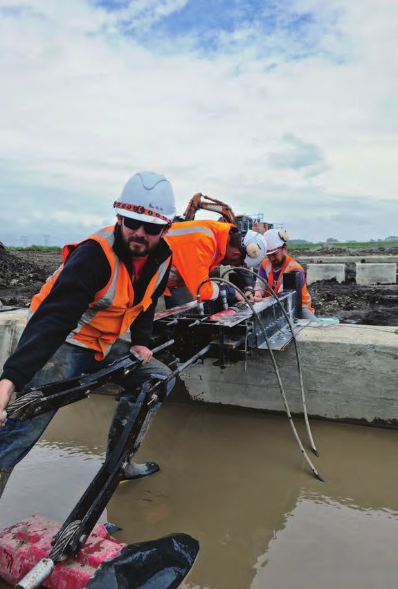
4                                                                       2020 EQC Research and Resilience Update

WELCOME TO THE 2020
EQC RESEARCH AND
RESILIENCE UPDATE
Sid Miller,
Chief Executive

2020 has certainly been quite a year, with Covid-19   I hope you find this update on some of our key areas
affecting nearly everything we do at work and at      of work over 2020 a useful insight into how we are
home. EQC has been determined to stay on track        contributing to a more resilient New Zealand.
with our work on risk reduction and resilience,
knowing that natural hazards remain one of
New Zealand’s biggest everyday risks.

In April, Dame Silvia Cartwright’s report of the
                                                      Sid Miller
Public Inquiry into the Earthquake Commission was     Chief Executive
released. The report contained a considerable
number of recommendations relating to how EQC
can play a greater role in building resilience to
natural hazards. I’m pleased to say that work is
already underway on many of these
recommendations as we pursue our mission to
reduce the impact on people and property when
natural disasters occur. Others, we will be
incorporating into next year's work programme.
2020 EQC Research and Resilience Update                                                                       5

Dr Jo Horrocks, Chief Resilience
and Research Officer

It’s been just over a year since we launched our        During the year, many of us had the chance to pause
Resilience Strategy for Natural Hazard Risk Reduction   (briefly!) and reflect on how science has advanced
setting out how we will work to reduce natural          since the Darfield earthquake on 4 September 2010,
hazard risk and increase resilience in New Zealand      while acknowledging that there is still so much more
over the 10 years to 2029.                              to learn and do.

During 2020, we have focused and streamlined our        We know that reducing risk and building resilience
data and research funding to drive our goal of          in New Zealand is a team effort across a huge
stronger homes, on better land, served by resilient     number of people and organisations, and we are
infrastructure. And we have continued to support        proud to be contributors to that effort.
EQC’s critical role of accessing international
reinsurance.                                            This report gives a snapshot of some our work over
                                                        the past year. As always, if there is something you
We have also had a strong focus on making new           want to know more about, or are keen to work on
knowledge accessible, and getting it into the hands     together, please don’t hesitate to get in touch at
of people making decisions that can increase the        jhorrocks@eqc.govt.nz.
resilience of our homes, towns and cities.

                                                        Dr Jo Horrocks
                                                        Chief Resilience and Research Officer
6                                                                          2020 EQC Research and Resilience Update

INTRODUCTION

If you live in New Zealand, natural hazards come        affect us, and much we can do to lessen the impacts
with the territory. But that doesn’t mean disasters     if and when they do.
have to.
                                                        Our vision is that natural hazards resilience becomes
Disasters come with the decisions we make about         embedded in all aspects of decision making for our
where people live and work, the buildings they are      homes, towns and cities.
in, and the infrastructure connecting those buildings
into communities, towns and cities. Disasters may       This report provides an update on some of EQC’s
seem inevitable and intractable, but there is much      research and resilience activity over the past year to
we can do to reduce the chance that hazards will        help New Zealanders reduce natural hazard risk and
                                                        build resilience.

    “Natural hazards are inevitable.
    Natural disasters are not.”
    John Filson, USGS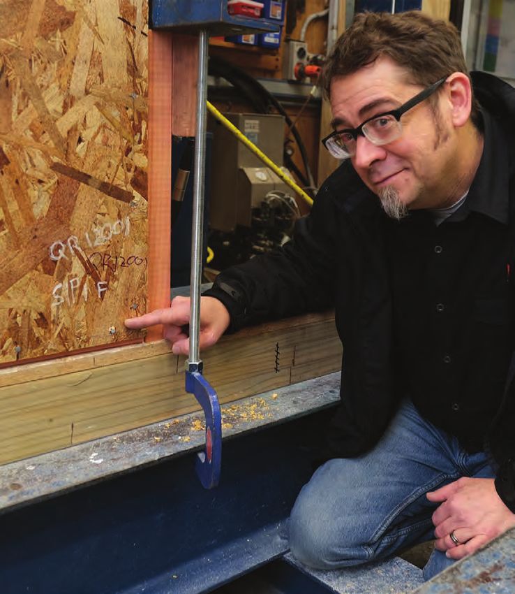
2020 EQC Research and Resilience Update                                                                 7

HAZARDS EQC COVERS

EQC provides natural hazards insurance for damage
to homes and land from earthquakes, volcanic
activity, landslips, tsunami and hydrothermal
activity—and residential land damage from
storms and flood.

                                                    EQC’S
                                                    RESILIENCE
                                                    GOAL

                                                    Our resilience goal is to inform, enable and influence
                                                    the choices and decisions that reduce vulnerability
                                                    and the exposure of New Zealand’s built
                                                    environment to natural hazard events. In simple
                                                    terms, the result we want to see is stronger homes,
                                                    built on better land, served by resilient
                                                    infrastructure, supported by affordable risk capital.

                                                    To do this, we fund research to develop scientific
                                                    evidence for decision making; we put this into forms
                                                    that decision makers can easily use; and we help get
                                                    that evidence into the hands of the people who can
                                                    make a difference.
8                                                     2020 EQC Research and Resilience Update

Four focus areas
We pursue four key things to help reduce risk and
build resilience in New Zealand.

                       A better understanding of               Creating a more resilient
                New Zealand’s natural hazard risks                   built environment

                                                           Photo: University of Canterbury

                          Reducing current risks to
                            our built environment            Smarter land-use planning
2020 EQC Research and Resilience Update 9
BUILDING THE
EVIDENCE BASE
EQC invested more than $16 million in the Data from GeoNet sensors are available, free of
2019/2020 financial year into science, research and charge, to all. These data provide the base for
data to help understand our natural hazard risks and natural hazards science on New Zealand.
ways of preventing or reducing those risks.
24/7 monitoring and analysis
We think of this as building the evidence for change. GeoNet data are analysed in near-real time at the
The more layers of evidence established through National Geohazards Monitoring Centre to provide
scientific insights, empirical research and fast information on natural hazard events to people
corroborating data, the greater the case for change managing emergency responses.
—for best practice, policy change or investment
in resilience.
GeoNet
Our largest investment, at $13.7 million in
2019/2020 is GeoNet, New Zealand’s natural hazard
monitoring system. With more than 700 sensors
nationwide, GeoNet monitors land and sea for
movement and activity relating to earthquakes, Public information
large landslides, volcanoes and tsunami. Automated GeoNet algorithms translate data into
New Zealand geohazard information available to all
through the phone app or the GeoNet website.
The data generated by GeoNet are used by response
agencies for alerts, warnings, and situational
awareness; by the public for hazard awareness; and Anyone can find out where earthquakes happened,
by science and research organisations as the basis what volcanoes are doing and how other hazards
for natural hazards science. Because of GeoNet, are tracking, and can contribute to New Zealand’s
New Zealand has some of the best knowledge of understanding of geohazards by submitting “felt”
natural hazards across its land of any country reports about their earthquake experiences.
worldwide.10 2020 EQC Research and Resilience Update
Investing in Measuring the strength
greywacke rock
science and
research “Ugly, unloved and under-researched” is how
Dr Carolyn Boulton describes the subject of her
In 2019, EQC reviewed where and how our research research—greywacke rock. Based at Victoria
funding could make the biggest difference to University of Wellington, Dr Boulton is sampling and
building New Zealand’s resilience. The result was our testing greywacke rock to discover how greywacke
Research Investment Priorities Statement, which responds to tectonic forces, particularly in “hosting”
guided decisions on awarding research funding large magnitude and multi-fault earthquakes.
in 2020.
The strength of a fault, and how much stress it can
Successful winners of Biennial Grants were withstand, fundamentally affects where
announced at the beginning of 2020, and in mid- earthquakes are generated and how they
2020 we also announced funding of eight three-year radiate energy.
university research programmes on key areas for
building New Zealand’s resilience. Although many of New Zealand’s recent
earthquakes have been in faults in greywacke
At any given time, EQC is funding more than 30 rock (e.g. Edgecumbe, Christchurch, Eketāhuna and
research projects looking at everything from deep Kaikōura) to date there has not been detailed study
and long-term geological studies, to construction of what happens in the rock itself during and after
lab tests delivering results that can be used by an earthquake and what this could mean for
builders within months. future earthquakes.
Understanding natural As part of her project, Dr Boulton is collecting
samples of greywacke rock in and near faults. She
hazard risks will then analyse their strength and stability. This
Reducing risk and building resilience starts with an will include subjecting the rock samples to simulated
understanding of the nature of the risk, the drivers earthquake processes in laboratory experiments.
of risk, and how hazards could impact us now and These experiments will be performed at
in the future. This helps identify where the greatest temperatures up to 450°C and pressures equivalent
opportunities are to make a difference. to those at depths between 10 and 15 km below the
Earth’s surface.
There are many formal and informal ways of
identifying, assessing and evaluating hazards and Results from the research will be used by other fault
risks. Some will be informed by local and traditional researchers and earthquake modellers to provide
knowledge, others through a more technical or better estimates of New Zealand’s earthquake risk
scientific approach. and help answer the question of why New Zealand
has so many multi-fault earthquakes.
EQC aims to increase our collective understanding
of natural hazard risks by investing in science,
research and data and building capability in risk and
loss modelling.2020 EQC Research and Resilience Update 11
Dr. Carolyn Boulton in greywacke country
Low seismicity, not low risk In each case, the perception of “low seismicity” has
meant that buildings and people in the area are less
New Zealanders in some parts of the country tend prepared for an earthquake than in high seismicity
to think that living in a “low seismicity” area means areas such as Wellington.
they are safer from earthquakes. But research
underway shows that this may not be the case. Earlier research has shown that faults in low
seismicity areas have an irregular pattern of rupture.
Professor Mark Stirling at the University of Otago is They may be quiet for many thousands of years and
leading research on faults in Southland, and GNS then produce earthquakes and significant
Science’s Dr Pilar Villamor is investigating a newly aftershocks for a long period of time (decades).
discovered fault near Morrinsville in the Waikato
which has the potential to generate a moderate to
large earthquake.12 2020 EQC Research and Resilience Update
Prof. Mark Stirling at the Hyde Fault. Photo: Guy Frederick
The current projects will build a record of pre-1840
Different soil, same
earthquakes on the faults, and this in turn will help
liquefaction effect
provide an estimate of the likelihood and magnitude
of future earthquakes on a fault. Before the 2016 Kaikōura earthquake, it was
generally understood that sandy soil has high
Working alongside Professor Stirling is Dr Caroline liquefaction potential. The 2016 quake, however,
Orchiston from the University of Otago Centre for also triggered liquefaction in gravelly soil areas
Sustainability. She is looking at some of the around Blenheim and Wellington’s waterfront.
challenges decision makers face in making their
communities more prepared for earthquakes. In Dr Gabrielle Chiaro, from the University of
particular how the Building Act has been Canterbury, is leading research to understand how
implemented in low seismicity areas. gravelly soil liquefies and what can be done to
mitigate the risk.
Bringing the geological and social science points of
view together will give a fuller picture of what is The team has been drilling 15 metres below the
needed to build community resilience and provide a ground surface in locations around Blenheim. They
case study that can be used to help other “low are using specially developed Cone Penetration Test
seismicity” areas like Auckland and Waikato be equipment (CPT) which can push a large steel cone
more prepared. into the ground and measure the soil resistance
it meets.2020 EQC Research and Resilience Update 13
Dr Gabriele Chiaro drilling gravelly soil in Blenheim
Soil samples are also being taken back to the lab so can use to identify locations that might be at high
that the team can determine the exact size and liquefaction risk, and to make better-informed
shape of particles in the liquefaction-prone soil, decisions about building on this type of land.
along with what the mix is of gravel, sand and silt.
Plug or flow? How
In the second phase of the research, the soil
samples will be placed into a custom-made
hydrothermal fluids change
laboratory testing apparatus at the University of
the plumbing of a volcano
Canterbury where the team will replicate the type Hydrothermal fluids (hot water and gases)
of earthquake load that can cause liquefaction. circulating inside a volcano change the physical
properties of rocks. As a result, volcanic rocks
The research will apply to other areas around New experience complex processes, such as dissolving
Zealand where there are either natural or reclaimed and forming new minerals, which ultimately control
soils with the same makeup (e.g. Wellington’s the flow of fluids through them. If these fluids can
waterfront which is reclaimed gravelly soil). easily circulate within the volcano, subsurface
pressures are mostly released at volcano vents,
Results from the research will be used for improving
crater lakes and fumaroles. However, if flow
local hazard maps. The research will also be used to
pathways get plugged due to the precipitation of
build a database of gravelly soil susceptible to
minerals, fluid pressures build up and are later
liquefaction that councils, planners and developers
released in explosive eruptions.14 2020 EQC Research and Resilience Update
Her analysis will help transform geophysical images
into rock physical properties of a volcano's plumbing
system. It will also help geoscience researchers and
hazard modellers improve volcanic activity
monitoring, forecasting pressure buildup and
mapping possible dome collapse areas.
Reducing current risks to
our built environment
The resilience of our built environment— homes,
buildings and infrastructure—is a key component of
Shreya Kanakiya with information on her study overall community resilience.
of fluids in volcanoes
Buildings that cannot stand severe events tend to
In parallel, hydrothermal rock alteration also
be the greatest source of loss of life and injury and
changes the strength of the rocks, which can result
the greatest source of cost in disasters. Damage or
in volcano flank collapse as debris avalanches.
disruption to critical infrastructure can have
To probe the inside of a volcano and image this flow-on effects to all parts of society, causing
hydrothermal alteration, seismic waves and the economic and wellbeing impacts.
magnetic properties of rocks are used; to date,
While many disaster risk reduction efforts are
however, these data cannot be directly associated
focused on reducing future risks— through risk-
with the physical changes of rocks. Geophysical,
informed land-use planning, smarter development
geological and geochemical laboratory studies are
and improved engineering techniques – it is
needed that link the rock hydrothermal alteration to
important to address risk that already exists in our
geophysical signatures.
building stock and infrastructure.
Shreya Kanakiya, a PhD researcher at the University
This can involve techniques like seismic
of Auckland's School of Environment, is analysing
strengthening, retrofitting and other measures
datasets on hydrothermally altered rocks from
designed to increase the safety of buildings and
Whakaari and Taranaki Maunga volcanoes. She is
infrastructure.
analysing “fresh” and altered rocks in the lab at
pressure conditions resembling those within For EQC this means assessing and analysing risk
the volcano. levels, investing in research on strengthening
solutions and raising the awareness of stakeholders
Ms Kanakiya is deciphering how mineral dissolution
and homeowners about measures they can take to
and precipitation due to hydrothermal alteration
protect their property and whānau.
changes porosity, permeability and geophysical
properties at great depths in volcanoes.2020 EQC Research and Resilience Update 15
Making old walls Once a successful strengthening system is
established, results will be used to develop a design
stronger walls
methodology that engineers can easily and reliably
Wellington’s CBD alone has more than 100 pre-1982 use to design the appropriate strengthening
multi-storey buildings, including apartment solution for each situation.
buildings, that are potentially at risk from
earthquake damage. This research is also being supported by Mapei New
Zealand, Sika, Holmes Consulting Group, Allied
Walls in multi-storey buildings built in the 70s and Concrete NZ and Concrete New Zealand.
early 80s can be at risk of buckling or bowing
horizontally through the cross section under seismic
loads. This is due to how they resist axial
compression loads combined with the thinness of
walls from this era. Dr Enrique del Rey Castillo from
the University of Auckland is leading a research
project to investigate the use of Carbon Fibre
Reinforced Polymer (CFRP) to strengthen reinforced
concrete walls.
Currently there are no New Zealand or international
guidelines for how the walls can best be
strengthened, meaning that owners need to find a
separate engineering solution for each building. This
adds cost and leads to inconsistency in how things
are done.
Dr del Rey Castillo and his team are currently
running tests on smaller sections of concrete that
simulate the critical edges of the walls.
Dr del Rey Castillo (left) with PhD researcher Victor Li in the
They will then move to building four-metre high lab are testing ways of making walls stronger. Photo: Victor Li
walls typical of the era.
These walls will be tested to simulate the multi-
storey loading levels and the seismic action on the
walls, using different combinations of CFRP
strengthening.16 2020 EQC Research and Resilience Update
Lab testing of reinforced concrete
Reducing earthquake
hazard in workplaces
Much has been done to reduce the structural risks
of buildings for business and their customers over
the ten years since the Darfield earthquake, but
much less is known about what businesses have
done to reduce other earthquake risks.
Researchers Dr Tracy Hatton and Sophie Horsfall
from Resilient Organisations and Dr Toni Collins,
University of Canterbury, are talking to businesses
nationwide. They want to discover how much of a
priority earthquake risk reduction is, and what has
been done to improve seismic safety.
Warehouse workplace damage during the Christchurch
earthquake sequence2020 EQC Research and Resilience Update 17
Researchers Dr Tracy Hatton (right) and Sophie Horsfall are surveying businesses about earthquake safety
Fixing cabinets and other heavy furniture to walls
Bridge piles get a
and securing equipment (such as air conditioning
strength test
units in ceilings and light fittings) are among some of
the improvements that have emerged in the early Destructive testing on the decommissioned
round of qualitative interviews. Whirokino bridge and trestle has given Dr Lucas
Hogan and his University of Auckland research team
The team is also running a nationwide survey of detailed data on the performance of bridge piles
businesses to find out what has worked and what still common across the country.
the key challenges are for improving seismic health
and safety. The team is particularly keen to The 90-year-old bridge and trestle on State Highway
understand if, and how, businesses see reducing 1 south of Foxton was replaced earlier this year by
earthquake risk as part of their overall Health and Waka Kotahi NZ Transport Agency. A wider $70m
Safety obligation. structure was built over the Manawatū River and
Moutoa floodplain, offering an unprecedented
The research team will use the survey results to opportunity for real-life earthquake testing.
produce a Best Practice booklet, sharing what
has worked, which will be freely available to
all participants.
Dr Lucas Hogan (left) on site at Whikorkino Bridge with PhD researcher Pavan Chigullapally18 2020 EQC Research and Resilience Update
Bridge piles ready to test
As well as extracting the bridge columns and assess what an earthquake could mean for transport
shipping them to the University of Auckland on these bridges and the communication or
Structures Lab for testing, the team has been pulling sewerage services that may be running along them.
the exposed foundation piles back and forth to
simulate earthquake movements. So far the Engineers and infrastructure owners in New Zealand
foundations have held up well under the and internationally are keenly waiting for the
huge deformations. results, due in late 2020, given the unique
opportunity to gather data from pushing real bridge
The research, co-funded by EQC and QuakeCoRE, is piles to their limits rather than using models in labs.
being carried out in cooperation with Waka Kotahi,
as the owner of the bridge. Sub-contractors Jurgens Creating a more resilient
Demolition are working alongside the lead
contractor, Fletcher Construction, who have
built environment
fine-tuned the deconstruction programme to fit Reducing risks to the current building stock is
with the scientific needs of the University of critical for reducing impacts and losses from natural
Auckland team. hazards in the immediate future.
Once the field work is completed, Dr Hogan and However, the cheapest and easiest time to
team will create a computer model to assess the minimise risk is to build resilience in the planning,
vulnerability of other bridges around the country design and development phase.
and help prepare for future earthquakes.
This is particularly the case with new buildings and
There are still many bridges with these types of piles infrastructure and in land-use planning. Building
in the country, especially over braided rivers in the resilient homes and infrastructure in low-risk
South Island in areas potentially affected by the locations, means new risks are not created, and
Alpine Fault. Knowing the strength and costly “retrofitting” or other risk treatment options
vulnerabilities of these types of bridges will help will not be needed in the future.2020 EQC Research and Resilience Update 19
Faster construction, high
quality, and just as strong?
Testing is underway at BRANZ to make sure that construction speed and potentially reduce cost for
structural insulated panels (SIPs), a relatively new homes and low-rise buildings, perform well under
building system in New Zealand that can increase New Zealand’s seismic conditions.
Dr David Carradine checks SIPs panel performance after a test round20 2020 EQC Research and Resilience Update
Next, the SIPs will be tested in combination with
other common New Zealand wall bracing systems
such as timber and plasterboard. This will ensure
that potential failure has not simply moved to
another part of a building and allow a better
understanding of the interactions among different
wall systems.
As well as providing data on performance, the
research aims to address the consenting challenge
of SIPs. SIPs are currently considered an “alternative
Structural Insulated Panels solution”, so owners often need to get an engineer’s
assessment of compliance with the New Zealand
SIPs, sandwich panels made of two face layers (like
Building Code, adding time and cost to a project.
timber, metal or cement) and an insulating rigid
foam core, have been widely used overseas for Once results are analysed and reported (expected
walls, roofs and floors for several decades, but are to be March 2021) manufacturers, council
only now moving into wider use in New Zealand. consenting teams and designers/engineers should
be able to follow a simpler and more commonly
The panels can be prefabricated and assembled
understood process for compliance, knowing that
quickly on site, providing structural bracing and
SIPs have been tested against New Zealand’s
insulation in one system.
Building Code.
Dr David Carradine is leading the structural testing
workstream as part of a wider BRANZ project Connecting cross-laminated
looking at how the panels stand up to climate, fire timber walls for high
and earthquakes. performance
Cross Laminated Timber (CLT) makes it possible to
Lab testing includes subjecting the panels to
build multi-storey timber buildings that are as
simulated earthquake and strong wind loads as part
strong as reinforced concrete buildings, but lighter
of standard New Zealand engineering tests to
and more environmentally sustainable.
evaluate in-plane strength, stiffness and how the
panels dissipate shaking energy.
Accelerated aging tests on typical SIP connections
are also underway to ensure the system will
continue to perform in the long term.
Dr Carradine says that, so far, things are looking
good with SIPs able to resist the simulated
earthquake loading, but not failing globally, while
also dissipating energy.2020 EQC Research and Resilience Update 21
The team will develop and test new anchoring and
connection systems, including the use of long (up to
1000mm) self-tapping screws on three-story CLT
walls scaled to 2/3. Data from extensive lab testing
will be used to create and validate models, which
can then evaluate the performance of different
building sizes.
Currently there are no New Zealand standards or
guidelines for using CLT, although there are believed
to be around 100 buildings under construction using
CLT. Final results from the research will be used to
write detailed guides on the most effective CLT
anchoring and connection systems and how to
design and build using them.
How much more would
stronger buildings cost?
Building damage and demolition that occurred as a
result of the Christchurch earthquakes and Kaikōura
earthquakes, has prompted new thinking on ways to
encourage developers and owners to build stronger
than New Zealand’s current “life safety”- based
building code.
In Wellington, after the Kaikōura earthquake,
several major nearly-new buildings were damaged
beyond repair and had to be demolished, in spite of
Dr Minghao Li (right) and PhD researcher Ben Moerman being built “to code”.
are testing CLT wall connections
At the University of Canterbury, Dr Minghao Li and The main reason given for not designing buildings
PhD researcher Ben Moerman are putting CLT less likely to be damaged is the additional cost, but
structural walls and wall connections through their to date there is very little data on how much that
paces to see how they would stand up to shaking cost would be.
from earthquakes or wind loads.
Research underway by Dr Enrique del Rey Castillo at
CLT is made of structural timber boards glued the University of Auckland aims to quantify the
together—essentially a much thicker version of extra cost of building reinforced concrete buildings
plywood. Previous research has shown that CLT to higher levels of earthquake performance.
walls are strong and stiff, but the common Concrete New Zealand is co-funding the research.
connections between walls and to the foundation
are not strong or stiff enough.22 2020 EQC Research and Resilience Update
We can see houses around the country that are
built too close to the edge of cliffs in the face of
coastal erosion; are on flood area plains subject to
repeated flooding; at sea-level on the coast subject
to repeated inundation by storm surge; or are built
on unstable or “creeping” land rapidly becoming
degraded. Other than the life safety issues these
can cause for individuals and communities, these
sorts of planning decisions present a contingent
liability that can often—and in very short order—
become insurance claims.
Dr del Rey Castillo
EQC supports research and data collection to
Dr del Rey Castillo is developing an extensive
understand how land is affected by natural hazards,
database of “model” buildings that have been
and to develop ways of mitigating natural hazard
created using the Building Modelling System. His
risk. These include techniques for strengthening
focus will be on model buildings with reinforced
land or planning that avoids development on the
concrete moment resisting frames and shear walls.
highest risk land.
These buildings will be used to create a costing
database, including factors such as greater
quantities of concrete and steel, the additional time
Reading variations in the
and labour required and various construction Earth’s gravity field in
methods. The database will be linked to buildings Wellington’s CBD
with different levels of seismic strength to enable an With some parts of the Wellington CBD affected
analysis of how much additional cost is involved in significantly more than others in the 2016 Kaikōura
each case. earthquake, University of Victoria at Wellington
Professor Tim Stern and masters degree student
Once the model has been tested, Dr del Rey Castillo
Alistair Stronach decided to take close look at
will develop a tool that will allow designers,
variations in the thickness of the sedimentary rock
developers, builders and policy makers to then
Wellington is built on to see if that could provide
easily compute the additional build cost for a given
an explanation.
increase in a building’s seismic strength. They can
then make cost-effective decisions on buildings that To do so, they are using a high-precision gravity
are less likely to be damaged in an earthquake. meter to measure small changes in the Earth’s
gravity field that are due to variations in the
Smarter land-use thickness of low-density sediments below
planning the surface.
Where homes are built is a critical factor in creating This will give them an indication of how the
or reducing natural hazard risk for our homes, amplitude of seismic waves is modulated in
towns and cities. Wellington CBD, and what this could mean for the
level of shaking felt on the surface.2020 EQC Research and Resilience Update 23
Tropical cyclones and severe rainfall, combined with
the relatively young, soft rock and soil much of the
city is built on, has already resulted in landslide
damage to houses, with some demolished.
Alistair Stronach (left) and Professor Tim Stern on site in
Wellington CBD measuring gravity changes
The gravity surveying work will feed into a study at
GNS Science. The study uses computer modelling of
how waves could travel through the Wellington
sedimentary basin, which sits between the
Wellington Fault and the postulated Aotea Fault,
thought to be aligned with Kent Terrace.
Part of the research is to determine the exact
position of the Aotea Fault. With two faults on
either side of the city, seismic waves, particularly
from a distant earthquake, are thought to be
amplified as they reflect and become trapped in the
soft sedimentary rock between the faults.
A close look at Gisborne
landslides
As EQC claims data demonstrates, landslides are a
major source of damage for homes. Matt Cook, PhD
researcher from Auckland University’s School of
Environment, says that Gisborne brings together a
“perfect combination” of conditions for landslides.24 2020 EQC Research and Resilience Update
Mr Cook is working closely with the Gisborne affecting dwellings. At present, hilly areas of the city
District Council to map the extent and rate of slope are part of a blanket landslide risk zone, but this
movement in the city, and to gather data on historic does not provide certainty to landowners about
landslides—some under existing buildings—to potential risks on their site. A key result of this
understand what could cause them to move again project will be the ability to make property-level
and identify other locations with similar conditions. assessments of risk.
Initially, his research will use remote sensing
Shedding light on
technologies such as LiDAR (Light Detection and
Ranging), which uses light transmitted from a laser
liquefaction
mounted on an airplane to map elevation change With liquefaction firmly established as a major risk
and InSAR (Interferometric Synthetic Aperture to homes and communities following the
Radar), which emits microwaves from a sensor Christchurch earthquake sequence, New Zealand
mounted on a satellite. These imaging tools are used has become a “natural laboratory” for
to measure ground movement to see both historic understanding liquefaction risk, and ways of
landslides and areas where the ground is now strengthening land and buildings against it.
moving slowly, potentially as a precursor to a
Professor Misko Cubrinovski of the University of
sudden major landslide.
Canterbury has been an international leader in
liquefaction research since the Canterbury
earthquakes, and has received multiple awards on
his work.
Over the next three years, with funding from EQC’s
University Research Programme, Professor
Cubrinovski will lead research targeting ways of
improving engineering assessments of soils and
structures to better identify locations and buildings,
which are vulnerable to liquefaction.
Along with identifying vulnerability, the research
will deliver methodologies and tools for designers,
Matt Cook is investigating landslides in Gisborne
engineers and local councils to support them in
decision making that will increase earthquake
resilience.
The Gisborne/Tairawhiti region is fortunate to have
full LiDAR coverage, acquired during the past two
The research will involve detailed analysis of soils
years, which allows for the difference from earlier
and how they behave under earthquake shaking:
urban LiDAR to be used as part of the assessment.
This will be simulated in the purpose built UC
Geotechnical Engineering lab. Target areas for soil
With Gisborne City having a history of urban
investigation will be 55 sites in Christchurch and
landslides, Gisborne District Council is fully
reclaimed land under Wellington’s port.
supporting the new research, which will allow
potential landslide risks to be mapped in detail,
giving a more precise assessment of landslide risk2020 EQC Research and Resilience Update 25
Championing better land-
use planning
Land-use planning has a major impact on New
Zealand’s resilience through both natural hazard risk
management and climate change adaptation.
EQC is co-funding a programme, hosted by GNS
Science, to support long-term land-use decision
making that balances risk and development.
EQC’s investment will focus on work to support local
authorities’ understanding and use of the Resource
Management Act, increasing planning profession
engagement in better management of natural
hazards, and raising awareness of natural hazards
planning within university courses.
As a first step, all councils will be surveyed about
capability and capacity issues. Results from the
survey will be used to understand what Continuing
Professor Misko Cubrinovski (front right) observing
Professional Development courses could be
damage on Wellington’s waterfront
developed to encourage better management of
Funding for Professor Cubrinovski’s research also natural hazards. The survey will also identify what
provides support for student researchers to work resources would best assist councils in their
alongside him, gaining experience and learning skills decision making.
and approaches for their own future research.
EQC is funding the programme for three years.
Rockfalls on cliffs, Redcliffs following Christchurch earthquakes 2011. Photo: Graham Hancox26 2020 EQC Research and Resilience Update
Building research The Alpine Fault: when AF8 goes big! will take Year 6
-8 students across Kā Tiritiri o te Moana/the
talent Southern Alps to discover the incredible powers,
which created the South Island landscape and still
New Zealand’s position as second-riskiest country in
pose a threat to our communities.
the world for natural hazard events (according to
Lloyd’s of London) has helped produce many Linking in with experts from the AF8 [Alpine Fault
world-leading natural hazard and risk reduction magnitude 8] programme, the field trip will visit a
scientists. EQC is committed to helping nurture the school close to the Alpine Fault to see how they
next generation of scientists, who will continue the have prepared themselves for natural hazards.
drive to understand our natural hazard risks and Students will also learn practical measures to
ways to reduce them. increase the preparedness of buildings to ensure
personal safety. And it all happens from the comfort
Virtual science visits of their classrooms.
from school
Further virtual field trips are planned for both
2020 saw the delivery of our twelfth LEARNZ virtual 2021 and 2022.
fieldtrip in partnership with CORE Education.
Alpine fault view along the west side of Red Hills. Photo: Lloyd Homer2020 EQC Research and Resilience Update 27
EQC University Research
Programme
July 2020 saw the start of the revised EQC University
Research Programme supporting visionary science
leaders to oversee research into different aspects of
natural hazard risk and risk reduction. Over the next
three years, EQC will fund eight university
programmes at five universities at $125,000 a year
each, to help build New Zealand’s resilience.
The funding supports research in fields ranging from
paleoseismology, geology and engineering to
economics and applying Mātauranga Māori to
disaster risk reduction.
Along with delivering advances in science, each of
the lead scientists will bring New Zealand’s next
generation of natural hazards scientists with them, PhD student Amanda Wallis at Disastrous Doctorates
offering guidance and experience to students on
This year, EQC’s Chief Resilience and Research
programme projects that will ultimately help them
Officer was invited to talk to the group about how
establish their own research careers.
EQC works to move research results into policy and
practice. Members of the EQC communications
Disastrous Doctorates team also ran a session giving tips on planning
Each year, EQC is the key funder of Disastrous effective science communication and dealing with
Doctorates—a three day forum for PhD students to the media.
share knowledge and skills, which is organised and
run by students themselves.
In February this year, more than 40 students from a
wide range of disciplines, all dedicated to reducing
the impact of natural hazards, met at the 2020
Disastrous Doctorates in Dunedin. Over the three
days they shared their research on everything from
deep volcano science to specialist lifejackets for
flood rescue workers, shared experiences of being a
researcher, and heard from people established in
science careers.
At Disastrous Doctorates28 2020 EQC Research and Resilience Update
Fulbright-EQC Graduate Aperture Radar—a technology that JPL has helped
to develop) learning the latest analysis techniques.
Award in Natural He will use his experience at JPL to analyse data
Disaster Research from Sentinel-1 satellites to measure very small
2020’s Fulbright-EQC Graduate Award winner, Jesse changes in vertical movement of New Zealand’s land
Kearse, is planning to head to the NASA Jet due to tectonic plate action when he returns to
Propulsion Laboratory (JPL) in California to gain New Zealand.
expertise in using satellite data—though Covid-19 is
This information will help him identify where in New
making it a delayed start due to travel restrictions.
Zealand is likely to be more at risk of sea level rise,
The Fulbright-EQC award gives young researchers with some areas lifting and some sinking towards
the opportunity to either do part of their graduate the sea by millimetres each year. Along with
degrees at a university in the USA or spend time as a providing detailed data on tectonic movement, the
visiting researcher at a centre of excellence there. information is critical to his PhD research at Victoria
University of Wellington looking at the localised
Mr Kearse aims to spend nine months with the effect of climate change and identifying areas that
world experts on INSAR (Interferometric Synthetic could be most at risk.
Jesse Kearse being presented with his award at Parliament by the Rt Hon Winston Peters, former Minister of Foreign Affairs2020 EQC Research and Resilience Update 29
MAKING SCIENTIFIC
EVIDENCE EASY TO USE
During our research review in 2019, it became clear bringing together data in accessible ways to help
that EQC, along with other natural hazards science ensure that decision makers have sound science
funders, supports many researchers delivering evidence in formats they can use.
excellent research, but that the research results do
Databases
not always have the influence they could on
decisions and actions. Researchers also told us that
they want their research to have more effect on Good data is the foundation of good decisions.
natural hazards resilience for New Zealanders. Intensive research over the last decade has
generated huge amounts of data, but organising
A key step in this pathway is to translate and
that data and making it accessible has been
operationalise scientific evidence into knowledge
a challenge.
that decision makers, who are often not scientists,
can use. EQC has been deeply involved in supporting two key
databases to ensure that good data relating to land
This year we are focusing a great deal of our effort
is freely accessible to people making decisions.
on improving modelling, building scenarios, and
New Zealand Geotecnical Database datapoint clusters30 2020 EQC Research and Resilience Update
Multiplying the power of Putting the landslide
geotechnical data picture together
The New Zealand Geotechnical Database (NZGD) is a EQC is working closely with the Auckland Council,
public/private resource that allows data from GNS Science, NZTA, KiwiRail and others to develop a
geotechnical tests to be uploaded once and shared National Landslide Database that will capture all
many times. This public and private sharing of current and future landslide information from local
geotechnical data is thought to be internationally and regional councils, Crown entities and
unique. geotechnical consultants.
In 2020, EQC took over full funding of the NZGD for The database will make it easier to identify and
three years while a future strategy for the database assess landslide hazard across New Zealand.
is developed with stakeholders and users.
So far, a successful pilot has been developed and
The NZGD now has more than 7,000 users, and is work is now underway to deliver a full working
conservatively estimated to hold test data worth database. The database will include an online map
over $500 million. Users of the database include of known landslides, along with information on the
researchers, councils, engineers and developers—all magnitude, type and impacts of landslides.
able to access tests that have already been done,
Modelling impacts
rather than needing to commission their own.
Providing easy and free access to geotechnical data
Computer models are increasingly being used as the
has many benefits, including supporting hazard
key tool to understand natural hazard risk, with
mapping and land-use planning for local councils.
advances in both science and computer technology
The NZGD is also being used in the development of
driving further capability in the speed and scope of
nationwide liquefaction modelling.
what can be incorporated into a model.
An output from the landslide database2020 EQC Research and Resilience Update 31
As well as providing essential information for risk EQC expects to replace its own inhouse model—
reduction decisions and action, loss modelling Minerva—with PRUE in the near future. A critical
provides information to reinsurers to help them element of the transition is ensuring that Minerva
assess their risk in New Zealand and to EQC for and our new model are fully reconciled in terms of
planning its response to events. the outputs they are delivering.
During 2020, EQC has continued to invest in New Once EQC’s modelling is powered by the RiskScape
Zealand risk modelling technology and science, engine, the new functionality will mean that EQC
including a range of smaller science projects looking can more easily add other hazards to its modelling,
at specific hazards. and undertake more complex modelling such as
compound and cascading events—such as landslides
RiskScape following an earthquake. This will give a fuller
picture of the potential impact of natural hazards.
National Seismic
Hazard Model
EQC has joined with MBIE and GNS Science to
update the National Seismic Hazard Model (NSHM).
The NSHM estimates the likelihood and strength of
earthquake shaking in different parts of New
Zealand and is widely used by government, industry,
reinsurers and insurers to help estimate earthquake
risk in New Zealand.
The update will be the first full revision of the model
since 2002 and will bring in advances in scientific
research and knowledge, including what has been
learned from the Christchurch earthquake
sequence, and the 2016 Kaikōura earthquake.
EQC’s Geoff Spurr and GNS Science’s Nick Horspool working Estimations from the NSHM provide critical
together on ensuring a smooth and accurate transition from
Minerva to RiskScape. Photo: Sam Blyth information for people making decisions about how
buildings are built, road and rail infrastructure,
A key investment for EQC is our new loss modelling insurance and civil defence planning.
suite, ‘PRUE’ (Portfolio of Residential Underwritten
Results from many research projects funded by EQC
Exposure), which is based on the RiskScape loss
will form part of the new knowledge incorporated
modelling engine developed by GNS Science and
into the update.
NIWA. RiskScape performs the calculations to
estimate the impact from natural hazards. EQC’s The update is expected to be complete in mid-2022.
contribution, both financially and strategically, will
help expand the functionality of the model, as well
as the science it can incorporate.32 2020 EQC Research and Resilience Update
Developing a model for The model will also aim to deliver an answer to the
critical question of what the maximum credible
multi-fault earthquakes earthquake could be in a particular location.
Mapping from historical earthquakes is a critical
part of developing a “fuzzy logic” model, which may In developing the model, Dr Stahl is focusing on an
help with forecasting which faults might set each area between Waiau and Blenheim, where one of
other off in future in multi-fault earthquakes. the most complex multi-fault earthquakes ever
recorded happened—the 2016 Kaikōura earthquake.
Using the Uniform California Earthquake Rupture
Forecast as a starting point, Dr Tim Stahl is Tsunami and volcanic
developing a model, which takes the particulars of loss modelling
New Zealand geology into account.
Starting in 2020, EQC is funding impact and loss
The new model will bring together the range of modelling projects for tsunami and volcanic hazards
factors that lead to multi-fault earthquakes, such as in New Zealand—two hazards that are typically not
the distances between fault lines, the orientations well quantified and ‘costed’ worldwide.
of angles between them, and the presence of minor
faults that might link up the more active segments. The tsunami project will be led by scientists from
GNS Science and the University of Canterbury and
Similar modelling of multi-fault earthquakes to date will use the Hawke's Bay region as a case study.
has been based on black or white filters for the
different factors. Dr Stahl’s model introduces fuzzy Results will be used for readiness, planning and
logic to put all the relevant factors together and insurance purposes, and have widespread
deliver a range of scenarios of what could happen. applicability to other tsunami-prone coastal areas
The scenarios will be tested against real-world data of New Zealand.
from past multi-fault earthquakes in New Zealand.
The volcano loss modelling project will leverage 10
years of volcanic hazard and impact research by
DEVORA (Determining Volcanic Risk in Auckland) to
undertake observational research and geospatial
modelling to understand and assess potential
volcanic impacts to the built environment. Its aim is
to develop a suite of scenario-based impact and loss
assessments, which will provide credible estimations
of the likely impact of different eruptions on people
and property in Auckland.
Dr Tim Stahl on fieldwork2020 EQC Research and Resilience Update 33
Developing
scenarios
A key programme of work for EQC in 2020 and
beyond is the development of a suite of nationally-
consistent, credible hazard scenarios that will
improve our ability to understand impact and loss
from natural hazard events. This will also test and
advance EQC’s readiness, event response, and
business continuity arrangements.
An agreed set of hazard scenarios, used effectively,
will provide a common understanding of New
Zealand’s risks. These scenarios will also provide a
consistent basis for mitigation actions, preparedness
and planning for both EQC and external stakeholders.
Each scenario will be described: the likelihood and
probability of the scenario occurring; likely impact
and loss data across social, economic,
environmental and built assets; capacity and
capability to respond; strategic considerations; and
any gaps or issues.
Our goal is to work with our loss modelling (science)
investments; broaden our hazard base; and develop
scenarios of varying magnitudes and locations, to
deliver depth and breadth of hazard type,
magnitude, location, probability, and damage.
A fictional volcanic eruption scenario
from exercise Rūaumoko (MCDEM, 2008)34 2020 EQC Research and Resilience Update
GETTING THE EVIDENCE
TO THE RIGHT PEOPLE
New Zealand’s natural hazard risk is reduced—or
increased—by the many people making decisions
about where and how New Zealanders build homes,
towns, cities and infrastructure.
This year, we have put an increased focus on
connecting and engaging with people involved in
policy and practice to bring them the evidence in an
accessible way.
We have continued to develop our relationship with
central government policy makers, local government
planning and consent officials, designers, engineers,
architects and builders, and, through our Public
Education programme, with homeowners.
We have also been successful in engaging media
to take our science stories directly to the
New Zealand public.
Bringing science EQC Science-to-Policy Forum
and decision from the policy and science communities, and
makers together further forums have been requested. We believe
such forums are useful for disseminating research to
EQC engages with policy makers and decision policy makers and practitioners; as a vehicle for
makers on a range of subjects, from building explaining policy needs to researchers; and a ‘safe
performance regulation to resource management space’ for testing policy approaches with a diverse
planning to economic policy. audience.
At the end of 2019, we hosted an inaugural EQC
Science-to-Policy Forum. The programme included
DEVORA—All about
20 speakers from the Resilience to Nature’s Auckland volcanoes
Challenges and Deep South Natural Science Auckland’s DEVORA programme—Determining
Challenges, Crown Research Institutes, universities Volcanic Risk in Auckland—brings together scientists
and consultancies, with nearly 60 policy with emergency managers, planners and
practitioners from central and local government in infrastructure providers to work together on
attendance. We had positive feedback on the forum reducing the impact of volcanoes in the city.2020 EQC Research and Resilience Update 35
Dr Sophia Tsang (left) and Alec Wild present volcano simulations at the 13th annual DEVORA research forum
EQC is a founding partner in DEVORA and continues
to be a major funder. With Auckland built on a
potentially active volcanic field, and vulnerable to
ashfall from other North Island volcanoes, a good
understanding of the likely risks and impacts is
important not just for the city, but the rest of
New Zealand.
Through DEVORA, scientists look to understand key
questions such as how often and how fast magma
rises to the surface in the Auckland Volcanic Field,
what patterns there have been in previous
eruptions, and what the likely impacts of different
eruptions could be in the future.
Science-based scenarios are developed to help
planners and decision makers work out what they
can do to reduce the impact of a future eruption.
It’s Our Fault—All
about Wellington
earthquake risk
EQC is a founding partner in It’s Our Fault, a
collaborative science and users-of-science group
looking at faults in the Wellington region, the
potential impacts of fault ruptures on the people
and property around them, and how those impacts
could be reduced.36 2020 EQC Research and Resilience Update
Along with earthquake hazard, the programme
looks at the Wellington region’s tsunami hazard,
hazard from landslides and rockfall triggered by an
earthquake, and liquefaction and fire following
earthquake. The programme also has a very strong
science-to-policy component to enable uptake of
the latest science into policy and planning.
It’s Our Fault has supported a significant number of
research projects, from active fault studies to
post-earthquake water supply restoration times to
land-use planning for natural hazards.
Science is shared with local communities, iwi,
councils and government to help the Wellington
region be more prepared and do what it can to
reduce risk ahead of hazards occurring.
Supporting resilient
infrastructure
EQC is a key supporter of the New Zealand Lifelines
Council (NZLC) and annual National Lifelines Forum, New Zealand, highlighting, in particular, the
which brings together researchers, policymakers, interdependencies of key infrastructure. Ultimately,
and infrastructure providers. the report aims to drive a change in the approach to
prioritising resilience investment and to increase the
Lifelines groups offer the platform for providers of
resilience of infrastructure to meet community
essential infrastructure and services such as water,
needs.
wastewater, electricity, gas, telecommunications
and transportation networks to work together on
projects to understand ways to reduce the impacts
Partnering with councils
of hazards on lifelines infrastructure. on science and data
Councils are critical decision makers for their
In 2020 EQC supported a significant update to the
communities. Each year we work with councils
National Vulnerability Assessment report. The
around New Zealand to help generate science and
report provides a summary of information on the
data they need for hazard risk management decision
vulnerability of New Zealand’s critical lifelines
making, including spatial and land-use planning.
infrastructure to hazards, including those resulting
from events such as volcanic activity, earthquakes, This year, for example, we provided advice and
and flooding. funding to Tauranga City Council to support the
development of its latest liquefaction hazard maps,
The report is intended to stimulate awareness of
funding and specialist expertise for the Marlborough
government, local authorities, utility providers,
District Council liquefaction hazard map project,
researchers and communities. It provides a unique
and seed funding to the Waikato Regional Council to
strategic perspective on infrastructure services in
support LiDAR data collection.You can also read