2022-2026 The Volcano Hazards Program: USGS Publications Repository
←
→
Page content transcription
If your browser does not render page correctly, please read the page content below
The Volcano Hazards Program:
               Strategic Science Plan for
                                      2022–2026

Circular 1492

U.S. Department of the Interior
U.S. Geological Survey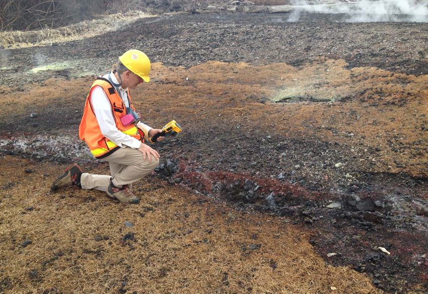
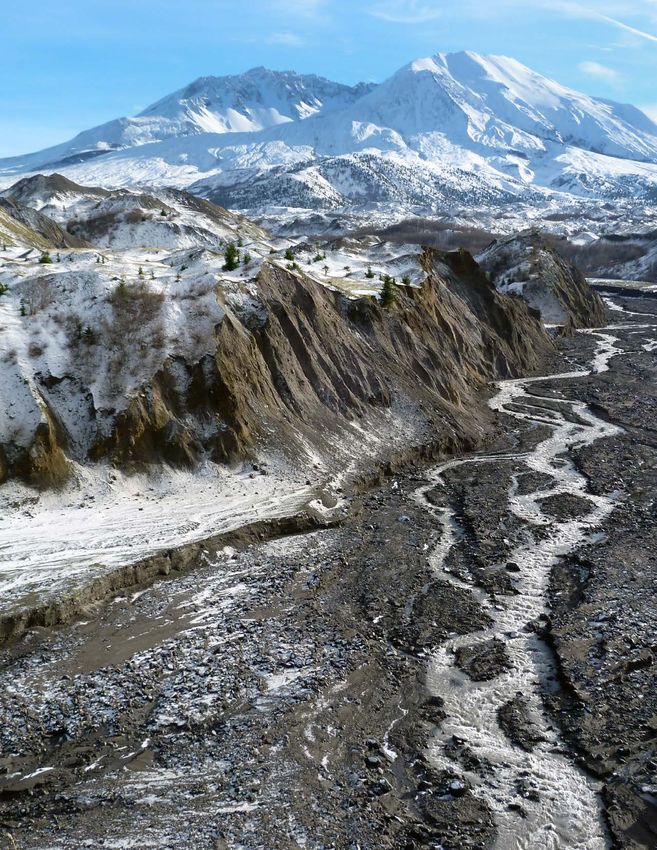
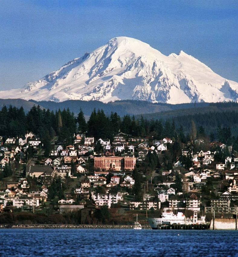
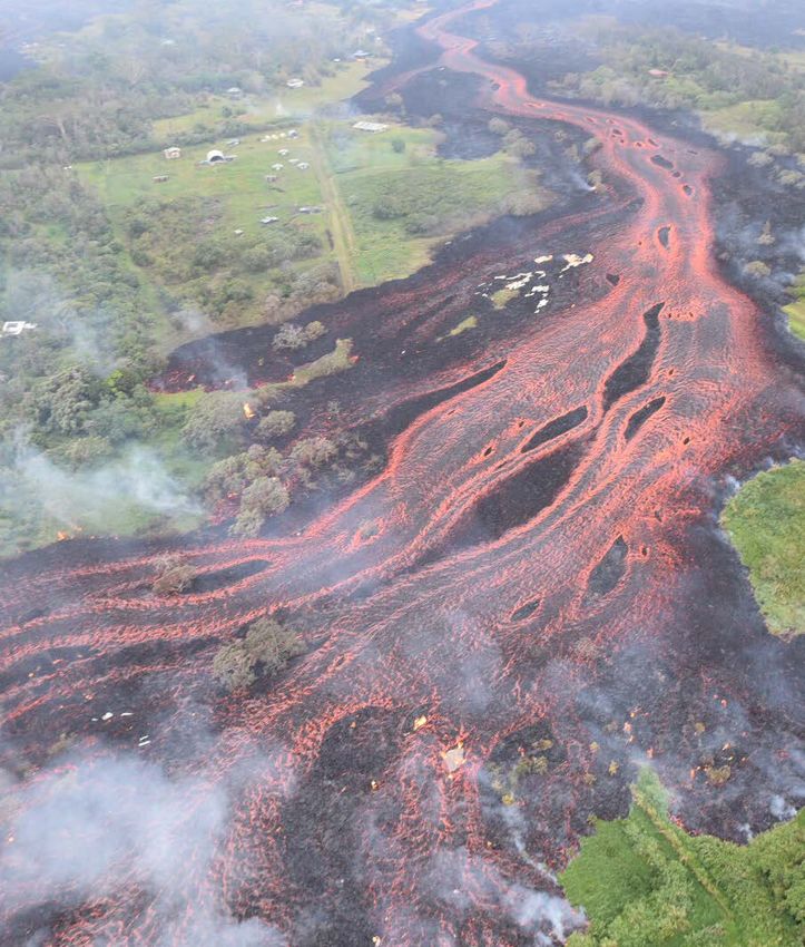
Cover. Front—Telephoto view of Mount Baker and the city of Bellingham, Washington, seen from Bellingham Bay. The glacier-
covered, 3,286-meter stratovolcano lies about 48 kilometers inland. Photograph by Brett Baunton, © 2008; used with permission.

Back— Fissure 8 (now known as Ahuʻailāʻau) spewing molten lava on June 13, 2018, during the lower East Rift Zone eruption of Kīlauea
volcano, Hawaii. Eruption point is from the small cinder cone at right containing four discrete fire fountains. The active lava channel is
approximately 30 meters (m) wide at the spillway out of the cone, broadening to 76 m at the bend and 100 m at the far left of the image.
Flow direction is from right to left. The maximum flow velocity in the channel just past the islands is 12 m/second (s). Seven standing
waves, visible in the middle of the channel starting at the bend, each have a wavelength of ~25 m. In combination, the flow velocity,
standing waves, and other parameters suggest a channel depth of ~4 m and thus a bulk effusion rate of ~1,200 m3/s (340 m3/s dense rock
equivalent) (see Dietterich and others, 2021). Photograph by Dr. Bruce Houghton, University of Hawaiʻi (Manoa); used with permission.
The Volcano Hazards Program:
               Strategic Science Plan for
                                                                            2022–2026
By Charles W. Mandeville, Peter F. Cervelli, Victoria F. Avery, and Aleeza M. Wilkins

Circular 1492

U.S. Department of the Interior
U.S. Geological Survey
U.S. Geological Survey, Reston, Virginia: 2022

For more information on the USGS—the Federal source for science about the Earth, its natural and living
resources, natural hazards, and the environment—visit https://www.usgs.gov or call 1–888–ASK–USGS.
For an overview of USGS information products, including maps, imagery, and publications,
visit https://store.usgs.gov.

Any use of trade, firm, or product names is for descriptive purposes only and does not imply endorsement by the
U.S. Government.

Although this information product, for the most part, is in the public domain, it also may contain copyrighted materials
as noted in the text. Permission to reproduce copyrighted items must be secured from the copyright owner.

Suggested citation:
Mandeville, C.W., Cervelli, P.F., Avery, V.F., and Wilkins, A.M., 2022, The Volcano Hazards Program—Strategic Science
Plan for 2022–2026: U.S. Geological Survey Circular 1492, 50 p., https://doi.org/10.3133/cir1492.

ISSN 1067-084X (print)
ISSN 2330-5703 (online)

ISBN 978-1-4113-4442-6
iii

Contents
Executive Summary .......................................................................................................................................1
Introduction.....................................................................................................................................................4
Alignment with the Natural Hazards Mission Area Strategic Plan (2013–2023) .................................6
Alignment with the USGS 21st Century Science Strategy ......................................................................7
Volcano Hazards Program Mission Statement and Objectives .............................................................8
Strategic Goals .............................................................................................................................................10
     1. National Volcano Early Warning System (NVEWS) ..................................................................10
     2. Preparedness ..................................................................................................................................15
     3. Volcanic Hazard Assessments .....................................................................................................17
     4. New Observations and Instrumentation .....................................................................................19
     5. Rebuilding the Hawaiian Volcano Observatory Facility and Its Monitoring Capabilities ...21
     6. Partnerships.....................................................................................................................................23
Scientific Targets .........................................................................................................................................27
     Volcano Seismicity (NVEWS and Hazard Assessment Goals) ....................................................28
     Probabilistic Eruption Forecasting (Preparedness and Hazard Assessment Goals) ..............30
     Eruptive Histories and Geochronology (Preparedness and Hazard Assessment Goals) .......33
     Eruption Physics and Parameterization (Preparedness and Hazard Assessment Goals) .....33
     Volcanic Clouds (Preparedness and Hazard Assessment Goals) ..............................................35
     Lava Flows (Preparedness and Hazard Assessment Goals) .......................................................36
Conclusions...................................................................................................................................................37
Acknowledgments .......................................................................................................................................38
References Cited..........................................................................................................................................39
Appendix 1. Comprehensive Volcano Hazards Program-Volcano Science Center
        Organizational Chart. ..........................................................................................................46
Appendix 2. A Brief Chronology of National Volcano Early Warning System (NVEWS)
        Legislation and Passage ...............................................................................................................48
Appendix 3. Resources for More Information .....................................................................................49

Highlights
USGS Volcano Hazards Program Overview...............................................................................................9
National Volcano Early Warning System (NVEWS) Optimization of Monitoring Networks ............14
New Observations from New Instrumentation—Gas Sensors ............................................................18
Volcano Remote Sensing.............................................................................................................................21
Unoccupied Aircraft Systems (UAS) in the Kīlauea 2018 Eruption Response ...................................22
Science as a Path to Diplomacy................................................................................................................25
Collaborative Partnerships.........................................................................................................................26

Figures
iv

     Conversion Factors
     International System of Units to U.S. customary units

                       Multiply                        By                  To obtain
                                                   Length
       centimeter (cm)                              0.3937    inch (in.)
       meter (m)                                    3.281     foot (ft)
       kilometer (km)                               0.6214    mile (mi)
                                                    Area
       square kilometer (km )     2
                                                    0.3861    square mile (mi2)
                                                   Volume
       cubic kilometer (km )  3
                                                    0.2399    cubic mile (mi3)
                                                  Flow rate
       cubic meter per second (m /s)  3
                                                    35.31     cubic foot per second (ft3/s)

     Abbreviations and acronyms
     ANSS                  Advanced National Seismic System
     ARRA                  American Recovery and Reinvestment Act
     AVO                   Alaska Volcano Observatory
     CalVO                 California Volcano Observatory
     CNMI                  Commonwealth of the Northern Mariana Islands
     CONVERSE              Community Network for Volcanic Eruption Response
     CSS                   Core Science Systems
     CVO                   Cascades Volcano Observatory
     DEM                   digital elevation model
     dVT                   distal volcano-tectonic
     EHP                   Earthquake Hazards Program
     FEMA                  Federal Emergency Management Agency
     FY                    fiscal year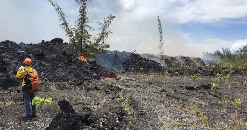
v

GIS      geographic information system
GPS      global positioning system
HVO      Hawaiian Volcano Observatory
ICS      Incident Command Structure
InSAR    interferometric synthetic aperture radar
ISRO     Indian Space Research Organization
NASA     National Aeronautics and Space Administration
NESDIS   National Environmental Satellite, Data, and
         Information Service
NHMA     Natural Hazards Mission Area
NISAR    National Aeronautics and Space Administration-Indian Space
         Research Organization synthetic aperture radar
NOAA     National Oceanic and Atmospheric Administration
NSF      National Science Foundation
NVEWS    National Volcano Early Warning System
NWS      National Weather Service
SAR      synthetic aperture radar
UAS      unoccupied aircraft system
USAID    U.S. Agency for International Development
USGS     U.S. Geological Survey
UV       ultraviolet
VAAC     Volcanic Ash Advisory Center
VAN      Volcano Activity Notice
VDAP     Volcano Disaster Assistance Program
VHP      Volcano Hazards Program
VONA     Volcano Observatory Notice for Aviation
VSC      Volcano Science Center
YVO      Yellowstone Volcano Observatory
3DEP     3D Elevation Program
24/7     24 hours per day, 7 days per week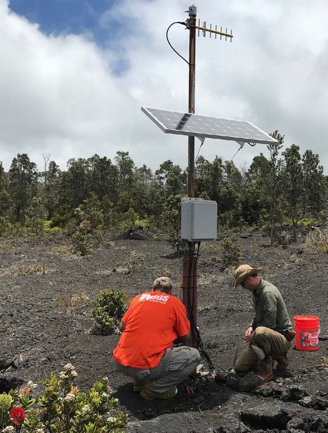
vi

     Symbols
     Ar      argon
     €       Euro
     C       carbon
     CO2     carbon dioxide
     H       hydrogen
     HCl     hydrogen chloride
     H2O     water
     H2S     hydrogen sulfide
     H2SO4   sulfuric acid
     He      helium
     K       potassium
     O       oxygen
     Pb      lead
     S       sulfur
     SO2     sulfur dioxide
     Th      thorium
     U       uranium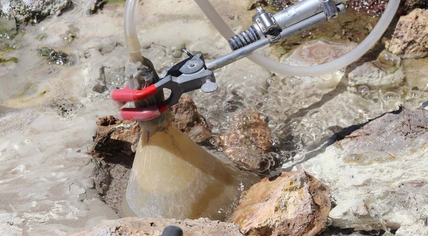
The Volcano Hazards Program:
                       Strategic Science Plan for
                                                                             2022–2026
 By Charles W. Mandeville, Peter F. Cervelli, Victoria F. Avery, and Aleeza M. Wilkins

 Executive Summary
       The U.S. Geological Survey (USGS) Volcano
 Hazards Program (VHP) Strategic Science Plan,
 developed through discussion with scientists-in-charge
 of the USGS volcano observatories and the director of
 the USGS Volcano Science Center, specifies six major
 strategic goals to be pursued over the next five years.
 The purpose of these goals is to help fulfill our mission
 to enhance public safety and to minimize social and
 economic disruption caused by volcanic eruptions,
 through delivery of effective forecasts, warnings, and
 information on volcano hazards based on scientific
 understanding of volcanic processes. These six major
 strategic goals are to—
         Continue—and when possible, accelerate—imple-
Goal 1

         mentation of the National Volcano Early Warning
         System (NVEWS) to close monitoring gaps on the
         highest threat volcanoes in the United States and to
         unify the five USGS volcano observatories into an
         interoperable system that has capability 24 hours
         per day, 7 days per week. To support NVEWS,
         standardize analytical software, acquire new infor-
         mation technology (IT) infrastructure, and add
         scientific staff to synthesize and interpret real-time
         and near-real-time data. This builds on investments
         already made during the American Recovery and
         Reinvestment Act stimulus of 2009–2010 and the
         use of one-time infrastructure funding in fiscal
         year (FY) 2018.

         Improve community preparedness for volcanic
Goal 2

         hazards by updating and standardizing essential
         components of volcano hazard assessments and
         providing training to land managers, emergency
         responders, and State and local communities in
         the form of tabletop exercises and development of
         effective emergency response plans. The USGS
         volcano observatories should build community
         relationships through briefings, town hall meet-
         ings, and use of social media that reaches poten-
         tially impacted populations.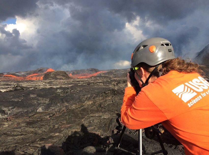
2   The Volcano Hazards Program: Strategic Science Plan for 2022–2026

         Update volcano hazard assessments, which for years have                 Rebuild the Hawaiian Volcano Observatory (HVO), which

                                                                        Goal 5
Goal 3

         been largely based on paper maps illustrating the zones                 was irreparably damaged during the 2018 eruption of the
         likely to be affected by ground hazards during a volcanic               Kīlauea summit and lower East Rift Zone. The new HVO
         eruption. A new generation of volcano hazard assessments                facility will be located in a less hazardous area (having
         will take the form of a digital portfolio of products and               a much lower probability of lava flow covering the area
         tools co-developed by the USGS and the end-user com-                    in the next 200 years) on the University of Hawaiʻi Hilo
         munity to best address their needs and make the informa-                campus and will also house USGS staff from the Pacific
         tion easier to understand and visualize. The new hazard                 Island Ecosystem Research Center. Rebuilding the HVO
         assessments will incorporate multiple layers of geographic              will eliminate single points of failure and will enable aug-
         information system (GIS) information and assessments of                 mentation of the monitoring networks for the Hawaiian
         exposure and risk to population and critical infrastructure.            volcanoes Kīlauea, Mauna Loa, and Haulālai. In addi-
         This portfolio of products will include Ash3d model runs                tion, the USGS will build a field operations station within
         for assessing impacts of ashfall in addition to ground-                 Hawaiʻi Volcanoes National Park for final assembly and
         based hazards.                                                          testing of select monitoring equipment just prior to perma-
                                                                                 nent installation, and to provide general fieldwork support.
         Make observations with new instrumentation and take
Goal 4

         advantage of advances in real-time gas sensors (for                     Form new partnerships and strengthen existing partner-

                                                                        Goal 6
         example, MultiGAS, miniaturized scanning differential                   ships, a goal of paramount importance in the next 5 years
         optical absorption spectrometers, and ultraviolet (UV)                  as the VHP seeks to implement NVEWS. Aiding this
         cameras), portable gravimeters, and other potential field               effort will be the requirement to leverage resources with
         surveys now possible, some of which are airborne. The                   other Federal and State agencies that already play a role in
         VHP must also take advantage of the proliferation of new                volcano monitoring. An additional goal is to form a high-
         remote-sensing synthetic aperture radar (SAR) satellites                level NVEWS Advisory Committee from Federal partner
         such as the National Aeronautics and Space Administra-                  agencies, and an NVEWS Implementation Committee
         tion (NASA)-Indian Space Research Organization (ISRO)                   with members from the scientific community, industry,
         SAR mission (NISAR mission) scheduled for launch                        land managers, and emergency responders that will have
         in September 2023. Other opportunities will arise from                  a direct role in the design of the NVEWS system and
         improved infrasound networks and more operational use                    a vested interest in successful implementation. Estab-
         of the World Wide Lightning Location Network for erup-                         lishment of an external grants activity as part of
         tion detection and situational awareness.                                            NVEWS implementation will also allow the
                                                                                                     VHP to grow partnerships with aca-
                                                                                                           demic scientists and industry on
                                                                                                                 select topics that align with
                                                                                                                       the goals identified in
                                                                                                                             this report.
Executive Summary 3
In its effort to advance volcano science and monitoring Improved physical models of magmatic systems and
Target 4
techniques, the VHP has identified several scientific targets to eruption processes through investigation of the param-
pursue over the next five years, including: eters that control eruption style, size, frequency, and
duration. These physical models will be used to support
Volcano seismicity, with emphasis on developing better probabilistic forecasts of eruptive activity. Models will
Target 1
integrated alarm systems that incorporate data from other be developed through numerical simulations that explore
types of ground sensors, and remote-sensing data. This the full range of key parameters and through experiments
target will also seek better understanding of the sources designed to fully capture the range of possible eruption
of distal volcano-tectonic earthquakes and their relation outcomes, with realistic assessments of uncertainties.
to volcano unrest and eruption. Other subfields to be Experiments will include the determination of water
explored under this target include better characteriza- (H2O)-carbon dioxide (CO2)-sulfur (S) solubilities in
tion of volcanic tremor, unification and integration of common magma types over a range of temperatures,
seismology and geodesy, more widespread use of infra- pressures, and oxidation states. This will allow us to
sound, and study of uplift at restless calderas. take better advantage of real-time gas measurements
with new sensors (for example, MultiGAS, UV cam-
Probabilistic forecasting through refining construction
Target 2
eras, miniaturized scanning differential optical absorp-
of Bayesian event trees and expert elicitation supported
tion spectrometers, and instruments employing eddy
by worldwide databases on volcano unrest and erup-
covariance techniques) and integrate those data with
tive activity. The VHP will ensure that forecasts include
petrologic information. Enhancement of the partner-
and clearly present the effects of uncertainties in the
ship with the Core Science Systems Mission Area of
data and models involved in their creation. Forecasts
the USGS will allow the VHP to take full advantage
will be informed from physics-based models of crustal
of high-performance computing facilities to develop
deformation and degassing, pyroclastic density current
and refine physical models of magma systems and
runout, debris flow dynamics, and ash cloud tracking and
eruptions processes.
ash fallout.
Improved volcanic aerosol measuring and tracking capa-
Eruption histories and geochronology at the Nation’s
Target 5
Target 3
bility through ground-based and airborne (unoccupied
threatening volcanoes through application of multiple
aircraft system [UAS]) measurements of sulfur gas emis-
geochronology techniques including radiocarbon,
sions from volcanic point sources. This includes continu-
potassium-argon (K-Ar), 40Ar/39Ar, uranium-lead (U-Pb),
ing the use of new gas sensors (MultiGAS and UV cam-
uranium-thorium (U-Th) disequilibrium, U-Th/helium
eras) already integrated with UAS platforms that have
(He), cosmogenic systems, stable isotope records in
proven successful during the Kīlauea eruption in 2018.
encapsulating sediments, and paleomagnetic compari-
The VHP will also continue to take advantage of more
son to calibrated secular variation maps to date volcanic
formalized partnership with the National Oceanic and
deposits and eruption processes precisely and accurately.
Atmospheric Administration (NOAA)/National Environ-
These dates and rates help the VHP and its partners bet-
mental Satellite, Data, and Information Service (NES-
ter understand the fundamental processes that control
DIS) and NASA to obtain low-latency remote-sensing
eruption size, location, frequency, cause, probability, and
satellite data from new ozone and sulfur gas detection
hazard. Continued success and USGS leadership in this
sensors aboard NOAA- and NASA-operated satellites.
field will require maintaining and improving VHP abili-
ties through staffing, programmatic focus, and laboratory Improved modeling and forecasts of lava flow paths
Target 6
capabilities, including construction of a new laboratory to warn potentially impacted communities in a timely
building at Moffett Field, California. Goals for this target manner. Success of the lava flow forecasts, particularly
in the next five years include improving tephra chro- on Kīlauea and Mauna Loa in Hawaiʻi, will depend on
nology records through integration of land-based and regular acquisition of new high-resolution lidar data
marine tephra records, publication of geologic maps and and the generation of accurate digital elevation models.
eruption histories, and investigations of the time scales The VHP will continue to collaborate with lava flow
of eruption periodicity and duration. modelers of Italy’s Instituto Nazionale di Geofisica e
Vulcanologia to bring their lava flow modeling programs
into operational use at HVO and make sure they are
adaptable to the types of lava erupted in Hawaiʻi. Under
NVEWS authorization, these models will be available to
all the USGS volcano observatories through standardiza-
tion of software and capability measures.4 The Volcano Hazards Program: Strategic Science Plan for 2022–2026
Introduction
The U.S. Geological Survey (USGS) Volcano Hazards ● New observations and instrumentation—Technologi-
Program (VHP) Strategic Science Plan identifies concrete and cal and conceptual advancements enable improved erup-
realistic goals that advance the VHP’s scientific and opera- tion forecasting and warning. Over the next five years,
tional mission, prioritizes them according to their immediate the USGS Volcano Science Center (VSC)1 will imple-
importance and likelihood of success, and recommends how ment new remote and in situ monitoring instrumentation.
the VHP can best achieve them, either independently or in
collaboration with academic, government, and other part- ● Rebuilding of the Hawaiian Volcano Observatory
ners. The plan addresses goals that share three distinguishing facility and its monitoring capabilities—The 2018
characteristics: innovation, importance, and feasibility over Kīlauea summit and lower East Rift Zone eruption led to
a five-year time scale. Although not stressed here, the impor- the loss of monitoring instruments and critical telemetry
tant day-to-day operations, which have made the VHP (also nodes and caused irreparable damage to the Hawaiian
referred to as “program”) so successful and effective since Volcano Observatory facility. The VSC will utilize fiscal
its inception, will continue. The new and innovative work year (FY) 2019 Disaster Supplemental Funds to replace
proposed below supplements—rather than supplants—the lost monitoring equipment, harden networks, reconfigure
VHP’s existing efforts, which remain essential for fulfilling its data telemetry, and construct a new observatory on the
primary mission. Pursuing the following major strategic goals Island of Hawaiʻi in a less hazardous area.
will enhance program operations over the next five years: ● Expanded partnerships—The strengthening of existing
● NVEWS implementation—Continued (and, when partnerships and formation of new partnerships with
possible, accelerated) implementation of the National universities and other government agencies is intended
Volcano Early Warning System (NVEWS) (Ewert and to advance volcano monitoring and increase understand-
others, 2005, 2018) is planned, including accompanying ing of volcanic processes, and to disseminate useful and
staffing increases. effective USGS information.
● Improved preparedness—The VHP will place a major 1
The line supervision of the five U.S. volcano observatories and their
emphasis on preparedness, both for communities at risk, respective scientific, technical, and administrative staff is under the Volcano
land managers, and emergency responders, and for the Science Center, which lies organizationally under the Alaska Region. The
VHP itself. Volcano Hazards Program Office provides scientific, administrative, and
budgetary leadership to the Volcano Science Center and is one of the programs
● Updated volcanic hazard assessments—To increase within the Natural Hazards Mission Area and located at USGS headquarters
the VHP’s preparedness to respond to crises, the pro- in Reston, Virginia. The work of the Volcano Hazards Program in terms of
gram will begin the development of a next generation of volcano monitoring and delivery of timely forecasts and warnings of hazard-
ous activity is executed by the Volcano Science Center (the five observatories
hazard assessments for the Nation’s very high threat and under its supervision) and the Cooperative Agreement Partners (the State
high-threat volcanoes. universities and geological surveys affiliated with the volcano observatories).
Appendix 1 shows the relationship between the Volcano Hazards Program and
the Volcano Science Center and its observatories.Introduction 5
In addition to setting the strategic goals listed above, the ● Eruption physics and parameterization—The pro-
VHP has identified several scientific targets, discussed below, gram will develop more accurate physical models of
on which it will focus during the next five years to advance volcanic systems, supported by physical data derived
volcano science and improve the program’s overall monitoring from a number of techniques, that have predictive capa-
capability and modeling of volcanic systems. These scientific bility supporting the generation of probabilistic forecasts
targets include the following: and warnings. Exploration of the full range of param-
● Volcano seismicity—The VHP will focus on several eters that control the appearance and type of eruption
aspects of volcano seismicity, including our under- precursors, as well as eruption style, size, and duration,
standing of co-eruptive tremor, distal volcano-tectonic will lead to better situational awareness and accuracy
earthquakes, integration of seismicity and geodesy, and of forecasts.
more extensive use of infrasound and development of ● Volcanic clouds—Volcanic ash and gas clouds can
automated alarms. impact population centers and critical infrastructure
● Probabilistic eruption forecasting—Delivery of hundreds to thousands of kilometers downwind of the
timely and accurate eruption forecasts is a core mission source and pose threats to commercial and military avia-
responsibility of the VHP, and the program will seek to tion. The VHP will work with its partners to improve
improve quantitative probabilistic eruption forecasts and warnings and forecasts of ashfall and gas emissions, and
assess uncertainties in light of new comprehensive erup- characterization of vog (volcanic smog) sources.
tion databases and more robust statistics now available. ● Lava flows—Lava flows from future eruptions of
● Eruptive histories and geochronology—Improving Hawaiian volcanoes will continue to threaten built
our understanding of eruption histories for the Nation’s infrastructure. With this in mind, the VHP is seeking to
threatening volcanoes will require utilization of multiple improve its lava flow modeling and tracking capabilities
age-dating techniques including radiogenic isotopes, and adapt existing lava flow modeling software to all
cosmogenic isotope exposure ages, stable isotopes, lava types. The VHP intends to fully utilize new digital
paleomagnetic data, and correlation of marine and elevation models derived from recent lidar surveys of
land-based tephra records integrated with major element the Kīlauea summit and lower East Rift Zone and plans
and trace element compositions of volcanic glass and to use digital elevation models when they are developed
mineral components. Developing more accurate erup- from more widespread lidar surveys to be conducted in
tive histories of volcanic centers will inform threat level the near term over the entire Island of Hawaiʻi.
assessments and also required levels of monitoring.6 The Volcano Hazards Program: Strategic Science Plan for 2022–2026
Alignment with the Natural Hazards Mission Area
Strategic Plan (2013–2023)
The USGS Natural Hazards Mission Area (NHMA)
generated a 10-year strategic plan (Holmes and others,
2013) to guide its efforts to make the Nation more resilient
to natural hazards. The plan identified actions to support
four overarching and interrelated goals:
● Enhanced observations
● Fundamental understanding of hazards and impacts
● Improved assessment products and services
● Effective situational awareness
Each of the VHP strategic goals and scientific targets
described below aligns with one or more of the overarching
goals of the NHMA strategic plan and was selected through
consultation with volcano observatory staff by scientists-
in-charge at each observatory, and subsequent deliberations
between the VSC staff, the scientists-in-charge, and the VSC
director. Alignment with one or more of the NHMA over-
arching goals and (or) their supporting actions were impor-
tant considerations for selection and development of the
strategic goals and science targets put forth in this VHP plan.Alignment with the USGS 21st Century Science Strategy 7
Alignment with the USGS 21st Century Science Strategy
The VHP Strategic Science Plan aligns with the compo- the NASA-Indian Space Research Organization (ISRO) Syn-
nents of the USGS 21st Century Science Strategy (U.S. Geo- thetic Aperture Radar (NISAR) mission data streams, and low-
logical Survey, 2021) of providing the Nation with relevant latency access to National Oceanic and Atmospheric Admin-
data, improving physical models with predictive capability, istration (NOAA)/National Weather Service wind field and
and delivering the data in actionable formats through dash- satellite-based remote-sensing data. Other examples include
boards and decision support applications in several ways, increased collaboration with National Science Foundation-
described as follows. First, the program seeks to improve situ- funded investigators from the academic sector or with State
ational awareness of the Nation’s active and potentially active geological surveys for leveraging of monitoring resources,
volcanoes by increasing the variety of ground-based sensors subject-matter expertise, and emergency response capability.
deployed on them through NVEWS implementation between These partnerships will be particularly important for presently
2022 and 2026. Second, as part of its NVEWS implementa- un-instrumented, moderate- and low-threat volcanic fields.
tion, the program is increasing the use of artificial intelligence Regional seismic networks and satellite-based remote sens-
and machine learning in developing automated alarms capable ing could indicate where campaign instruments should be
of analyzing real-time monitoring data from multiple instru- deployed as a volcanic field reactivates.
ment types. Third, the increased amount of data generated by Current operational program products that could feed
a built-out NVEWS will require the program to utilize cloud actionable information to the Earth Monitoring, Analysis and
hosting and computing, in addition to artificial intelligence and Predictions (EarthMAP) initiative of the USGS 21st Century
machine learning, to be able to efficiently and fully analyze, Science Strategy (U.S. Geological Survey, 2021) include (1)
synthesize, and interpret the data. the Ash3d physics-based model of ash transport and deposition
The VHP will continue to develop physics-based models (Schwaiger and others, 2012), (2) next-generation volcanic
of volcanic systems that will increase predictive capacity and hazard assessments, (3) the D-CLAW physics-based model
the ability to issue accurate forecasts and warnings of hazard- for debris flows and lahars (Iverson and George, 2014; George
ous volcanic activity. Alignment with the USGS 21st Century and Iverson, 2014), (4) Volcano Activity Notices (VANs;
Science Strategy will be achieved through enhancement of see https://www.usgs.gov/natural-hazards/volcano-hazards/
existing partnerships and establishment of new partnerships notifications), and (5) Volcano Observatory Notices for Avia-
that are relevant to successful NVEWS implementation. tion (VONAs; see https://www.usgs.gov/natural-hazards/
Examples include increased cooperation with the National volcano-hazards/notifications).
Aeronautics and Space Administration (NASA) and access to8 The Volcano Hazards Program: Strategic Science Plan for 2022–2026
Volcano Hazards Program Mission Statement and Objectives
The mission of the VHP is to enhance public safety and
minimize social and economic disruption from eruptions
through delivery of effective forecasts, warnings, and infor-
mation on volcano hazards based on scientific understanding
of volcanic processes. The objectives of the program are
to (1) respond to volcanic crises and (2) build capacity that
makes such responses more timely, accurate, and effec-
tive. Examples of activities under the first objective include
monitoring the geophysical, geochemical, and observational
signals that indicate volcanic unrest; forecasting erup-
tions; issuing warnings; and providing information to guide
responses by emergency managers. Examples of activities
within the second objective include research and develop-
ment to improve forecasting of eruptions and their hazards
and to enhance monitoring technology, and work with emer-
gency managers and communities to improve preparedness.Volcano Hazards Program Mission Statement and Objectives 9
USGS Volcano Hazards Program Overview
The United States and its territories are home to 161 be established in an eruption event, benefit from embedded
active and potentially active volcanoes (Ewert and others, USGS volcano observatory scientists and (2) emergency man-
2018), and have experienced a wide range of destructive vol- agers are familiar with USGS forecast and warning products,
canic phenomena. Within the Natural Hazards Mission Area subject-matter experts, and roles and responsibilities of USGS
of the U.S. Geological Survey (USGS), the Volcano Hazards observatory scientists ahead of volcanic unrest. Each volcano
Program (VHP) conducts its mission to enhance public safety observatory has its own unique and necessary culture, influ-
and minimize social and economic disruption from volcanic enced by geographic location, the types of volcanoes moni-
unrest and eruption through delivery of effective forecasts, tored and their eruption frequency, and the close relationships
warnings, and information on volcano hazards based on scien- developed with the public and with local emergency response
tific understanding of volcanic processes. The program does partners. However, the VHP is also striving toward more stan-
this primarily through the operation of five volcano obser- dardization of analytical software and increased interoperabil-
vatories managed under the Volcano Science Center (VSC), ity among its volcano observatories. The value of this interop-
headquartered in Anchorage, Alaska. The locations and areas erability was well demonstrated during the recent response
of responsibility of the five observatories are listed below and to the Kīlauea summit and lower East Rift Zone eruption of
shown in figures 1 and 2. 2018. Scientific and technical staff from all five volcano obser-
● Alaska Volcano Observatory (AVO)—Anchorage and vatories participated in the response, either through travels and
Fairbanks, Alaska; volcanoes in Alaska, the Com- temporary work assignments in Hawaii, or in a remote-duty
monwealth of the Northern Mariana Islands, and capacity as part of our 24/7 nationwide operations.
American Samoa. In addition to the five volcano observatories, the VHP—
in partnership with the U.S. Agency for International Develop-
● California Volcano Observatory (CalVO)—Menlo Park ment—operates an international arm of the program called the
and Moffett Field, California; volcanoes in California Volcano Disaster Assistance Program (VDAP), which pro-
and Nevada. vides support to volcano observatories around the world, with
an emphasis on those in developing countries. When requested
● Cascades Volcano Observatory (CVO)—Vancou- by the foreign country, VDAP undertakes a broad swath of
ver, Washington; volcanoes in Washington, Oregon, activities related to capacity building, equipment donation, and
and Idaho. training in diverse fields related to volcanology. VDAP staff
● Hawaiian Volcano Observatory (HVO)—Hilo, Hawaii; provide advice both during remote responses to eruptions and
volcanoes on the islands of Hawaiʻi and Maui, and during occasional in-country responses to eruptions. Lessons
the Lōʻihi submarine volcano, southeast of the island learned through VDAP activities and responses are then
of Hawaiʻi. applied to the domestic operations of the VHP (Lowenstern
and Ramsey, 2017). VDAP activities reduce risk and vulner-
● Yellowstone Volcano Observatory (YVO)—Vancouver, ability to volcanic hazards worldwide in many areas where the
Washington; volcanoes in Wyoming, Montana, Colo- United States has interests, assets, and operations exposed to
rado, New Mexico, and Arizona. volcanic hazards.
Each of the five USGS volcano observatories performs The VHP management structure reflects the matrix
real-time volcano monitoring, conducts core research on how management of the USGS, with a program office in USGS
volcanoes work, and establishes eruptive histories and hazards headquarters in Reston, Virginia. From the program office,
exhibited during past eruptions in order to prepare hazard the program coordinator sets the strategic science plan and
assessments for each of the Nation’s active and potentially annual program guidance, develops program metrics, coordi-
active volcanoes. The trifecta of monitoring, research, and nates with leadership of other Federal partners, answers data
hazard assessment strengthen and complement each other, calls from Congress and from USGS and Department of the
triggering mutual progress in these endeavors. All three core Interior leaders, manages the VHP’s cooperative agreements,
functions are interdependent in the VHP’s mission. The vol- and determines annual Congressionally appropriated funding
cano observatories also raise awareness of volcanic hazards to allocations to the VSC and other USGS organizational units.
the public, to emergency response communities, and to State The VSC has line authority over all five volcano observato-
and Federal land managers through active communication and ries and VDAP, and it thus has the massive responsibility for
outreach; such outreach includes collaborative co-develop- executing the science plan, conducting volcano monitoring
ment and generation of volcano-specific emergency response and eruption response, and developing regional, State, and
plans that increase community preparedness and resilience local partnerships. An organizational chart for the VHP is
to volcanic hazards. Generation of such emergency response shown in appendix 1.
plans ensures that (1) incident command systems, which may10 The Volcano Hazards Program: Strategic Science Plan for 2022–2026
Strategic Goals
1. National Volcano Early Warning System establishing a national volcano monitoring system (Lowen-
stern and Ramsey, 2017), and as of 2020 more than a dozen
(NVEWS)
nations had adopted the method. Congress, too, has shown
For more than a decade, the concept of a National bipartisan support for the NVEWS initiative. NVEWS legisla-
Volcano Early Warning System (NVEWS) has been a major tion was incorporated as Title V of the John D. Dingell, Jr.,
force driving program plans and efforts. First envisioned Conservation, Management, and Recreation Act that was
in 2003, NVEWS was formulated on the basic principle signed into law (Public Law 116-9) on March 12, 2019. This
that the Nation’s volcanoes require a level of monitoring first-ever authorization of NVEWS by Congress, covering the
commensurate with the threats they pose. Transforming years 2019 through 2023, marks an important milestone for
this principle into concrete action first required a thorough the Volcano Hazards Program that was approximately 15 years
assessment of the scope and nature of volcanic threat from in the making. Although authorization does not guarantee
each of the 161 active and potentially active volcanoes in the appropriations, Public Law 116-9 presents a strong endorse-
United States. From this assessment, along with a corre- ment for the objectives of NVEWS and authorizes the appro-
sponding evaluation of the exposed population and infra- priation of $55 million over the 2019–2023 period.
structure, a relative threat ranking of volcanoes ranging from The legislation states that “the Secretary of the Depart-
very high threat to very low threat was derived (figs. 1, 2). In ment of the Interior acting through the Director of the USGS
2005, the program completed compiling this relative threat shall establish within the USGS a system to be known as
ranking using information available at the time (Ewert and the National Volcano Early Warning and Monitoring System
others, 2005), with a subsequent updated ranking published to monitor, warn, and protect citizens of the United States
in 2018 using newly available data (Ewert and others, 2018). from undue and avoidable harm from volcanic activity.”
In 2008, guidelines were established for recommended lev- The legislation calls upon the USGS to organize, modernize,
els of instrumentation for a volcano of a given threat level standardize, and stabilize the monitoring systems of its five
(Moran and others, 2008). NVEWS implementation will volcano observatories in the United States and unify them
create new, high-quality data that improve the VHP’s abil- into a single interoperable system. The overarching objective
ity to warn of volcanic unrest and eruption and to enhance of this system, to ensure that all the volcanoes in the United
understanding of volcanic processes. Such understanding is States and its territories are monitored at a level commensurate
essential for effective forecasts. with the threats they pose, will be accomplished through the
Since its introduction, NVEWS has received much following activities:
attention and praise from emergency managers, the aca- ● Upgrading existing networks on monitored volcanoes.
demic community, and other stakeholders, both domestic
and international. The USGS NVEWS methodology is ● Installing new networks on unmonitored volcanoes.
rapidly becoming the world standard for prioritization of ● Employing geodetic and (or) other monitoring compo-
investments in volcano monitoring and related research. nents (for example, gas and infrasound sensors, visible
For example, the government of Chile was advised by the and infrared cameras, and seismic and gravity sensors)
Volcano Disaster Assistance Program on the importance of when and where applicable.Strategic Goals 11
125° 120° 115° 110° 105°
50°
EXPLANATION CANADA
Volcano threat category Mount Baker
Very High Glacier Peak
Seattle
High WASHINGTON
Moderate Mount Rainier Helena
Low Mount St. Helens Mount Adams
Very Low CVO/YVO
Vancouver, WA Mount Hood
Portland
Volcano observatory 45°
area of responsibility OREGON
IDAHO
Three Sisters Newberry Volcano Yellowstone caldera
CalVO—California Boise
CVO—Cascades
WYOMING
YVO—Yellowstone Crater Lake
HVO—Hawaiian Medicine Lake
Mount Shasta Salt Lake Cheyenne
City
Lassen Volcanic Center
NEVADA Denver 40°
UTAH
Clear Lake volcanic field
COLORADO
Sacramento
Mono-Inyo Craters
San Francisco
Long Valley Caldera
San Jose
CalVO
Las Vegas
Moffett Field, CA
Santa Fe
22° PA
CIF CALIFORNIA 35°
Honolulu IC ARIZONA NEW MEXICO
OC Los Angeles
EA Phoenix
N Salton Buttes
PACIFIC OCEAN San Diego
HVO
20°
0 50 100 KILOMETERS Hualālai
Hilo 0 125 250 KILOMETERS
0 50 100 MILES Mauna Loa Kīlauea 0 125 250 MILES
MEXICO
160° 155° AT 43° LATITUDE 30°
Base from https://www.naturalearthdata.com; WGS 84 Spherical Mercator projection
Figure 1. Map of the Western United States and Hawaii showing active and potentially active volcanoes and their relative threat
levels as designated in the National Volcano Early Warning System (NVEWS). Names are included for volcanoes in two threat
categories: very high threat and high threat. Also shown are the areas of responsibility for the California, Cascades, Yellowstone,
and Hawaiian Volcano Observatories.
The legislation calls for the following measurable progress in the name of public safety. The leg-
system components: islation directs the Secretary of the Interior to establish an
● A national Volcano Watch Office that is operational 24 advisory committee to assist the Secretary in implementing
hours per day, 7 days per week (24/7). The Volcano the system, to be composed of representatives of relevant
Watch Office will be merged into the National Volcano Federal agencies and members of the scientific community
Data Center as a cost-saving and efficiency measure. to be appointed by the Secretary. Members of the advisory
committee will be leaders from agencies with which Public
● A National Volcano Data Center (now referred to as the Law 116-9 directs the Secretary of the Interior to coordinate
National Volcano Information Service). The combined implementation activities: the Secretary of Transportation,
National Volcano Data Center-Volcano Watch Office will Administrator of the Federal Emergency Management Agency
operate on a 24/7 basis. (FEMA), Administrator of the Federal Aviation Administra-
tion, and Administrator of NOAA. Other relevant Federal
● An external grants activity to support research in vol- agencies with which the program already partners in volcano
cano monitoring science and technology. monitoring and research will also be invited, including the
Congress has strongly encouraged the strengthen- National Science Foundation and NASA.
ing of partnerships and leveraging of resources to achieve12 The Volcano Hazards Program: Strategic Science Plan for 2022–2026
Commonwealth of the Northern 140°
EXPLANATION
Mariana Islands (CNMI)
Volcano threat category
Very High
Alaska
High
20°
70° Moderate 70°
CNMI
PACIFIC Low
Agrihan Island
OCEAN
Pagan Island Very Low
0 100 KILOMETERS Volcano observatory
American area of responsibility
0 100 MILES Samoa ALASKA
Saipan AVO—Alaska
AVO
15°
Fairbanks
Guam
AVO
145° E CANADA
BERING Hayes Volcano
Mount Spurr
SEA Redoubt Volcano Anchorage Mount Churchill
American Samoa Iliamna Volcano
Augustine Volcano
Kaguyak Crater 60°
14° S Mount Griggs
Pago Pago Novarupta
Mount Douglas
Juneau
Mount Mageik Fourpeaked Mountain
0 100 KILOMETERS Mount Martin Snowy Mountain
Ugashik-Peulik Mount Katmai
170° volcanic complex Trident Volcano
0 100 MILES Shishaldin Volcano
Fisher Caldera Aniakchak Crater
Westdahl Peak
Mount Veniaminof PACIFIC OCEAN
Korovin Volcano Makushin Volcano
Pavlof Volcano
Atka volcanic complex Mount Okmok Akutan Island
Kasatochi Island 0 300 KILOMETERS
Mount Cleveland 0 300 MILES
Great Sitkin Island Seguam Island
AT 60° LATITUDE
Semisopochnoi Island Mount Moffett
180° Kanaga Volcano 160° 140°
50°
Base from https://www.naturalearthdata.com; WGS 84 Spherical Mercator projection
Figure 2. Map of Alaska, the Commonwealth of the Northern Mariana Islands (CNMI), and American Samoa, showing active and
potentially active volcanoes and their relative threat levels as designated in the National Volcano Early Warning System (NVEWS).
Names are included for volcanoes in two threat categories: very high threat and high threat. The entire region is within the area
of responsibility for the Alaska Volcano Observatory (AVO). The CNMI, an unincorporated territory of the United States, lies about
55 kilometers (km) northeast of Guam and extends northward for another 800 km along a chain of 15 islands, most of which have
active volcanoes.
Per Public Law 116-9, the VHP also prepared a five-year threatening volcanoes in the United States with approximately
management plan for establishing and operating the system, 200 ground-based instruments, during “phase 1” of NVEWS
which was transmitted to Congress on March 12, 2020 (this implementation (pending NVEWS specific appropriation),
was also published as a USGS Open-File Report [Cervelli and as well as the steps it will take to establish the components
others, 2021]). The plan contains the following components: of NVEWS listed above should funding be received at
● Annual cost estimates for modernization activities and the authorized levels. Progress on achieving the monitor-
operation of the system. ing standards proposed in the legislation for the majority of
moderate- to low-threat volcanoes and volcanic fields in the
● Annual milestones, standards, and performance goals. Intermountain West of the United States (in Colorado, New
Mexico, Arizona, Utah, Nevada, Wyoming, and Idaho) would
● Recommendations for, and progress toward, establishing compose a later “phase 2” of NVEWS implementation, where
new partnerships or enhancing existing partnerships to leveraging of resources from cooperative agreement partners
leverage resources. (including State universities and geological surveys), and
The NVEWS five-year management plan describes from Federal agencies operating remote-sensing satellites
the USGS strategy to close monitoring gaps on the 34 most (NASA, NOAA), will be increasingly important. The five-yearStrategic Goals 13
management plan complements a less-detailed, 10-year stations (for example, global positioning system (GPS) receiv-
NVEWS implementation plan written in response to Senate ers, infrasound arrays, gas spectrometers, visible and infrared
report language accompanying FY2017 appropriations (page web cameras, and sensitive digital broadband seismometers),
38 of Division G of Senate Report 114-218 that accompanied will require digital telemetry paths to accommodate new
Public Law 115-31): “The USGS is directed to report back and multivariate real-time data streams. In the summer field
to the Committee within 1 year of enactment of this act on season of FY2018, 15 analog stations were converted to new
the agency’s plan to repair, upgrade, and expand monitoring, digital stations having digital broadband seismometers and
detection, and warning systems and equipment on high-threat digital telemetry, and in the FY2019 field season, a total of 42
volcanoes.” That report was transmitted to Congress on analog stations were converted to digital. In the FY2020 field
June 19, 2019. season, 10 analog stations were converted to digital, despite
The VHP is not starting from scratch in its network challenges posed by the COVID-19 pandemic. In FY2021, an
modernization and augmentations efforts. On the contrary, additional 27 stations were converted, bringing the total down
work is well underway. Network modernization was initiated to 16 analog stations remaining. In addition, $1.0 million in
during the 2009–2011 application of $15.2 million of FY2009 FY2018 one-time funds were applied to continued develop-
American Recovery and Reinvestment Act (ARRA) funds to ment and installation of a new lahar detection system on
networks at all USGS volcano observatories. This work has Mount Rainier in Washington, replacing a system installed in
continued opportunistically since 2011. Following the passage 1998 that had reached the end of its expected service.
of ARRA, the already vetted and published NVEWS plans Augmentation of networks during NVEWS implementa-
(Ewert and others, 2005; Moran and others, 2008) offered tion will require a concomitant hiring of scientific, technical,
a clear roadmap to important, well-defined opportunities to and administrative staff. Augmented networks having a wider
advance the Nation’s volcano monitoring capabilities. Without variety of ground-based sensors and associated data streams
NVEWS, and without all the work put into establishing threat will require analysis by a greater number of scientists of vary-
rankings and conducting subsequent implementation studies, ing specialization (for example, geodesists, seismologists, gas
the VHP would have been an unlikely target for ARRA fund- geochemists, and remote-sensing geologists). Moreover, the
ing. Instead, the program’s “shovel-readiness” led to $15.2 instrumentation buildout and its long-term maintenance will
million in ARRA funds that paid for, among other projects, a require an associated hiring of additional field engineers and
complete modernization of the seismic network of the Hawai- technicians to service the networks following initial installa-
ian Volcano Observatory (HVO) (Okubo and others, 2014) and tion with regularly scheduled maintenance visits every 3 to
major improvements to the networks at the Alaska Volcano 5 years. Full buildout of NVEWS, assuming full authorized
Observatory (AVO), Cascades Volcano Observatory (CVO), funding of $11 million per year for five consecutive years, will
and Yellowstone Volcano Observatory (YVO). Maintaining a entail the installation of approximately 600 new sensors and
list of prioritized “ready-to-go” NVEWS implementation proj- the addition of approximately 60 staff members, consisting
ects from all observatories will be necessary in the next five of about 25 scientists and data analysts, with the remaining
years. It will also be necessary to establish a formalized and positions consisting of engineers, computer scientists, system
equitable vetting process for determining which NVEWS proj- administrators, and project managers. The timing of hiring and
ects go forward following a potential NVEWS appropriation. the number of new staff will be dependent on the size of future
Implementation of NVEWS under the 2019 authorization NVEWS appropriations and whether they are sustained.
remains the VHP’s principal strategic goal for volcano moni- Growth and augmentation of the Nation’s volcano
toring. NVEWS will build on modernization efforts already monitoring networks will continue over the next five years,
underway. In FY2018, Congress appropriated $14.5 million although the pace of work depends strongly on the size and
above the VHP base funding of $28.1 million as “one-time frequency of NVEWS specific appropriations. Moreover, the
infrastructure funds.” Within that total, $13.5 million was VHP faces the concurrent challenge of maintaining existing
used to buy equipment necessary for conversion of 117 instrumentation already in place, much of which has aged
analog monitoring stations to digital stations on high-threat past its useful lifetime and will require upgrade or replace-
volcanoes in Alaska. Completion of analog-to-digital station ment in the near future. Progress on all of these fronts will
conversions is a necessary prerequisite to NVEWS buildout continue to be tracked by the program as part of its annual
in Alaska because the addition of new instruments to these performance metrics.14 The Volcano Hazards Program: Strategic Science Plan for 2022–2026
National Volcano Early Warning System (NVEWS)
Optimization of Monitoring Networks
The U.S. Geological Survey (USGS) prioritizes
monitoring, research, hazards evaluation, and community
engagement at those volcanoes posing the greatest threat to
life and property when they erupt. Many of the most dan-
gerous volcanoes in the United States have only incomplete
monitoring networks and obsolete instruments with which
to detect the subtle signs of reawakening. Modernizing
these networks under NVEWS so that the Nation’s volca-
noes are monitored at levels commensurate with their threat
will create robust sources of real-time data and better situ-
ational awareness, and will allow the Volcano Hazards Pro-
gram (VHP) to improve detection of unrest. These benefits
of NVEWS implementation will allow the USGS and its
State and university partners to better warn of unrest, lead
to greater understanding of underlying volcanic processes,
shift eruption response from reactive to proactive, and ulti-
mately lead to more accurate forecasts of eruptive activity.
To increase the monitoring efforts at Mount Rainier,
Washington—one of the highest priority volcanoes accord- Scientists installing a digital broadband seismometer about
ing to NVEWS rankings—scientists installed a digital 18 kilometers west of the summit of Mount Rainier, Washington, in
broadband seismometer in the Puyallup River valley in the the Puyallup River valley. Photograph by Rebecca Kramer, USGS.
summer of 2017. The USGS VHP and the Pierce County
Office of Emergency Management plan to install digital
broadband seismometers in the other major river valleys
around Mount Rainier. These additional seismometers will
improve the volcano monitoring network so that scientists
may detect eruption precursors at the earliest stages.
U.S. Geological Survey (USGS) Cascades Volcano Observatory
geophysicists Martin LaFevers and Wes Thelen programming
seismic equipment in the enclosure at the Paradise lahar
detection station within Mount Rainier National Park, Recently completed Ohanapecosh lahar detection station in
Washington. In addition to addressing the normal challenges Mount Rainier National Park, Washington, placed beside existing
of doing fieldwork in remote locations, scientific staff in the utility service. In September and October 2020 the U.S. Geological
Volcano Hazards Program had to contend with personal Survey (USGS) Volcano Hazards Program installed five new lahar
protective protocols required by the COVID-19 pandemic. detection stations within the park to improve the new generation
Photograph by Liz Westby, USGS. lahar detection system. Photograph by Martin LaFevers, USGS.You can also read