289 FLAT BUSH SCHOOL ROAD - Flint's Park, Ladies Mile, Queenstown TRANSPORT ASSESSMENT REPORT PROPOSED INFRASTRUCTURE AND SERVICING REPORT
←
→
Page content transcription
If your browser does not render page correctly, please read the page content below

Flint’s Park, Ladies Mile,
289 FLAT BUSH    SCHOOL ROAD
           Queenstown
   TRANSPORT ASSESSMENT
 PROPOSED REPORT
          INFRASTRUCTURE
   AND SERVICING REPORT
          DATE: 5/3/19

   1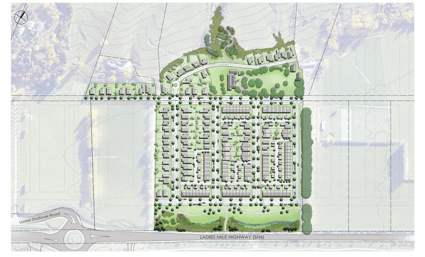
1    DOCUMENT CONTROL RECORD

Client             Glenpanel LP

Project            Flint’s Park, Ladies Mile, Queenstown

Document           Flint’s Park Ladies Mile, Queenstown TA

2    ISSUE

Date of Issue      V3 5/3/19

Originator         Colin Shields

Checked/Approved   Bruce Harland

Office of Origin   Ellerslie

Telephone          (09) 579 5505

Facsimile          (09) 579 5506

Email              colin.shields@candor3.co.nz

                                        2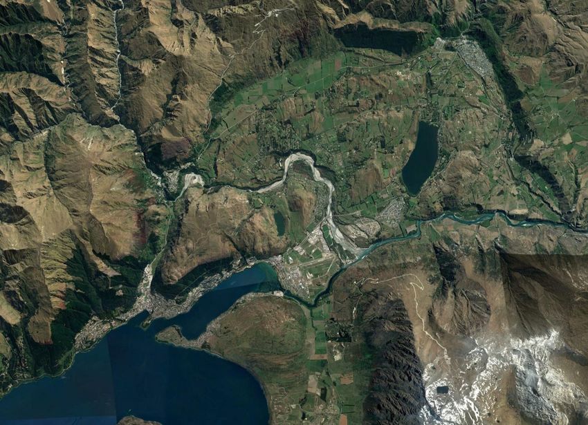
3   TABLE OF CONTENTS
    1    DOCUMENT CONTROL RECORD ...........................................................................................2
    2    ISSUE ..................................................................................................................................................2
    3    TABLE OF CONTENTS ................................................................................................................3
    4    EXECUTIVE SUMMARY ...............................................................................................................4
    5    INTRODUCTION ............................................................................................................................5
    6    SITE LOCATION AND EXISTING TRANSPORT CONNECTIONS ................................8
    7    PROPOSED SUSTAINABLE TRANSPORT CONNECTIONS ......................................... 10
    8    COMPLIANCE WITH RELEVANT TRANSPORT POLICIES .......................................... 12
    9    INTERNAL ROAD LAYOUT AND COMPLIANCE WITH STANDARDS ................... 15
    10   PARKING PROPOSALS AND COMPLIANCE WITH STANDARDS ............................ 19
    11   CONCLUSIONS ............................................................................................................................ 20
    12   APPENDICIES ............................................................................................................................... 21

                                                                               3
4    EXECUTIVE SUMMARY
This report has been prepared by Candor³ on behalf of Glenpanel Ltd Partnership to assess
the Transport Impact of the proposed housing Expression of Interest (EOI) submission at
the Flint’s Park, Ladies Mile Queenstown, Special Housing Area (SHA). The report
demonstrates that in transport terms, the site complies with relevant standards, is
deliverable, and will provide residents with good walk, cycle and bus connectivity to key
services and facilities.

                                              4
5 INTRODUCTION
5.1 Background
This Transport Assessment (TA) report assesses the transport related matters of the
proposal for up to 207 dwelling units at Flint’s Park, situated alongside the Ladies Mile
section of State Highway 6 in Queenstown. The intention of the assessment is to support
the Queenstown Lakes District Council (QLDC) SHA EOI submission.
5.2 Previous Masterplanning and Transport Studies
Queenstown Lakes District Council (QLDC) prepared an indicative masterplan for the wider
Ladies Mile area which is shown in Appendix A with the proposed Flint’s Park SHA overlaid.
Flint’s Park forms part of this wider masterplan. The proposed grid pattern masterplan layout
enables an efficient use of land for housing, as well as providing for convenient walking,
cycling and public transport connectivity. Planning consent via SHA was obtained for the
Queenstown Country Club element of this masterplan and construction has commenced on
this site with construction access utilising an existing farm track access directly from SH6.
In support of a Housing Infrastructure Fund (HIF) Business Case Bid, an Integrated
Transport Assessment (ITA) was carried out on behalf of QLDC which assessed the impact
of the proposed QLDC indicative masterplan and identified a package of transport measures
to mitigate the impact of this scale of development. The Detailed Business Case was
QLDC’s formal request to obtain a $19.2 million HIF loan (with repayments being made from
development contributions) and $6.5 million at 51% via the Local Road Funding Assistance
Rate (FAR) as a separate $6.5m HIF funded loan directly to the National Land Transport
Fund (NLTF), not QLDC. A FAR (Funding Assistance Rate) of 51% was assumed due to
the significant access improvements for the Lake Hayes Estate and Shotover Country
communities and the safety improvements for all traffic through the Howards Drive
intersection.
Therefore, the Business Case was prepared for a total investment of $26.4 million to provide
infrastructure to unlock developable land for 1,100 dwellings in the Ladies Mile development
corridor, of which Flint’s Park is part of. The transport works identified included:
Access via a roundabout controlled intersection at SH6/Howards Drive ($7.65m).
One pair of bus stops and bus shelters on SH6 (location to be confirmed) ($2.37m).
SH6 pedestrian/cycleway underpass near bus stops ($2.23m).
Footpaths along SH6 to the underpass and bus stops.
Access in later stage of development from Lower Shotover Road and SH6/McDowell
Drive.
Internal bus stops (developer to provide).
Increased bus frequency and direct routes.
Park and ride hub for ‘Cromwell’ traffic.
SH6 bus priority.
Reduce SH6 speed limit to 80km/h.
QLDC, Otago Regional Council (ORC) and NZTA have since agreed a programme
(Programme 3) of funding for these improvements.
The detailed business case identified that developers will be responsible for the funding and
construction of all the internal roading and 3 waters infrastructure with QLDC being
5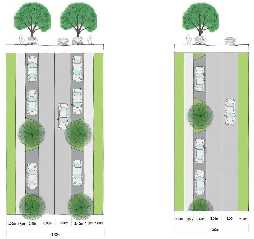
responsible for the construction of all external transport and 3 waters infrastructure. The HIF
loan will assist with respect to funding.
As such, the wider transport impacts of the Flint’s Park development have been assessed,
and the wider off-site transport mitigation measures required have been identified and
agreed upon. Therefore, this TA reviews the proposed internal walking/cycling/bus
connectivity, the proposed internal road layout and construction traffic access prior to the
opening of the SH6/Howards Drive roundabout.
5.3 Development proposal
The development proposal consists of 151 dwelling units as follows:
71 terrace Houses – typically 3 to 4 bedrooms with 2 onsite parking spaces. Some
of the units will be served via private laneways/JOAL.
68 standalone houses - typically 3 to 4 bedrooms with 2 onsite parking spaces.
12 duplex – typically 3 bedrooms with 2 onsite parking spaces.
The existing Homestead end use is as yet undefined but potential uses include a gastro
pub/restaurant or an art gallery/café. Onsite parking for these uses would need to be
established, but it could be possible to provide circa 40 onsite parking spaces with these
types of uses.
A Neighbourhood Park is proposed adjacent to the existing Homestead and a Liner Park is
proposed on the eastern boundary of the site. This Linear Park retains the Oak Tree
Driveway and links Ladies Mile with the Neighbourhood Park and the Historic Homestead.
Appendix B indicates the roads and private laneways/JOAL’s proposed as part of the Flint’s
Park development.
In general accordance with the QLDC Ladies Mile masterplan (see Section 5.2 above) a
landscape setback with extensive tree planting from State Highway 6 (SH6) is proposed.
Within this landscape setback a 3m wide shared footway/cycleway will be provided.
Appendix A shows how the proposed Flint’s Park masterplan connects with the rest of the
QLDC indicative masterplan in terms of overall site access, walking, cycling and bus
connections to. For example, the Local Centre and connectivity of the rest QLDC masterplan
with the proposed Neighbourhood and Linear Parks and the Homestead. As such, the
proposed Flint’s Park masterplan is in accordance with the rest of the QLDC masterplan and
provides safe and convenient walk, cycle, bus and car connectivity to the Local Centre, as
well as providing connectivity to the proposed Parks and Homestead.
Details of the Flint’s Park sustainable transport connections and the proposed internal road
layouts/parking compliance with QLDC standards is provided in Sections 9 and 10 of this
report.
5.4 Construction Traffic Access
In advance of the New Zealand Transport Agency (NZTA) finalising the design and
construction of the access point on SH6 at Howards Drive, it is proposed that construction
access to the Flint’s Park site be taken from the existing private access/driveway on SH6.
Preliminary comments from NZTA have indicated that this is acceptable.
6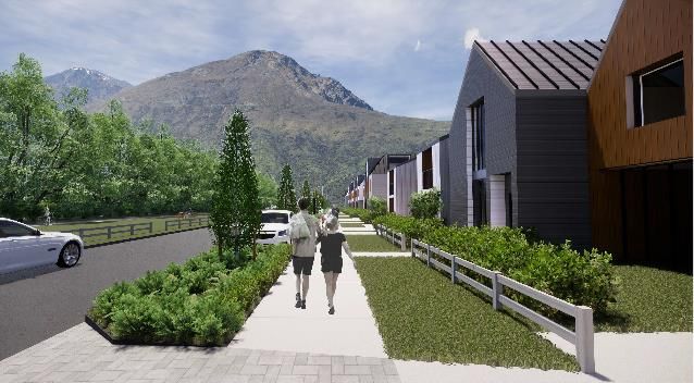
5.5 Intended use for the TA
This TA report is intended to support the EOI for a SHA application for the Flint’s Park
development and has been prepared with the guidance specified in the Integrated Transport
Assessment Guidelines - Research Report 422 published by the NZTA. This TA report
provides details on:
A description of the site and its surrounding transport environment.
Proposed sustainable transport connections.
Compliance with relevant transport policies.
Review of internal road layout and proposed parking provision.
Conclusions.
7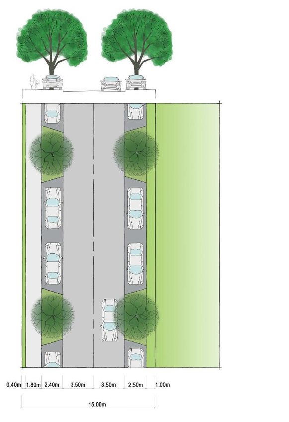
6 SITE LOCATION AND EXISTING TRANSPORT CONNECTIONS
6.1 Background
The site location is shown in Appendix C. The site is located on the north side of Ladies Mile
approximately half way between Queenstown and Arrowtown. The proposed development
area is adjacent to two major residential developments: Lake Hayes Estate and
Shotover County (including a primary school which opened in 2015).
The site is adjacent to SH6 (Ladies Mile) which provides road connections to Queenstown
CBD, Queenstown Airport/Frankton and wider South Island destinations. SH6 also provides
an opportunity to link into key public transport routes between Arrowtown,
Lake Hayes Estate/Shotover Country and the Frankton transit hub.
In 2017 the Flint’s Park site was incorporated into the wider area QLDC Special Housing
Area (SHA) Lead Policy. The Queenstown Country Club SHA on the opposite side of Ladies
Mile has been consented and construction has commenced. A roundabout was constructed
in 2016 at SH6/Stalker Road to serve Shotover Country to the south of Ladies Mile and a
large commercial development is developing nearby, at Frankton Flats. It is understood that
an EOI has been submitted for the Laurel Hills element of the Ladies Mile Masterplan. In
2017 public transport improvements within the Queenstown area included a bus route along
SH6 with a regular, inexpensive bus service. The simplicity of the routes and timetables,
combined with the new fare system, has resulted in bus patronage more than doubling. In
2018 the Wakatipu High School relocated to Remarkables Park. Employment in
Queenstown has historically been focused in the CBD, though Frankton is increasingly
becoming a significant employment centre.
6.2 Existing Site Accessibility and Connectivity
6.2.1 Walking and Cycling
Residents of Flint’s Park will have easy walk access to the proposed Neighbourhood Park
and Linear Park for recreational uses, and also will be within an easy 300m (4 minute walk
time) of the Local Centre and Plaza as per proposed the QLDC Ladies Mile masterplan. It
is understood that this will contain key local services for residents of Ladies Mile.
Via the proposed network of footways and cycle routes, residents will also have access to
the adjacent Queenstown Trail and the open countryside for leisure and recreational uses.
The Flint’s Park site is located circa 1km (12.5 minute walk /3 minute cycle ride) to
Shotover Primary School. The QLDC Ladies Mile masterplan includes a pedestrian/cycle
underpass located east of the SH6/Stalker Road roundabout adjacent to the Flint’s Park
site. The Laurel Hills concept design allows for a footpath connection on the east side of
Stalker Road from the SH6 roundabout and the urban area of Shotover country. This
proposal would provide a safe and direct walking/cycling link between the Flint’s Park site
and the school. There are existing pram crossing points across SH6 at the Stalker Road
roundabout with the raised median function as a pedestrian refuge, which provides fora safe
and direct crossing for pedestrians and cyclists to Stalker Road and onwards to
Shotover Primary School.
The Flint’s Park site is located
Circa 4.5km from the Five Mile Shopping Centre – this contains key retail activities,
a bank, pharmacy and other services.
8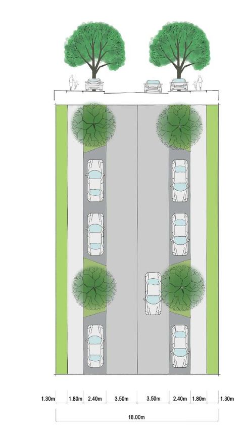
6.5km from Queenstown Airport and Queenstown Hospital.
7.5km from the Remarkables Shopping Centre – this contains key retail activities, a
medical centre, pharmacy and other services). Wakatipu High School is also located
here, as well as various commercial developments in the Frankton area.
12.5km from Queenstown CBD.
Cycle access to these destinations is via Lower Shotover Road/Spence Road to the
Queenstown Trail (Twin Rivers Ride) at Lower Shotover Bridge. From here a segregated
route is provided via the Queenstown Trail Connector Trails and the Lake Wakatipu Ride to
the Five Mile shopping Centre, Queenstown Airport, Queenstown Hospital, the Remarkables
Shopping Centre, Wakatipu High School, Frankton commercial developments and
Queenstown CBD.
6.2.2 Bus
Services
There are currently 2 bus services (routes 2 and 4) adjacent to the site on SH6 Ladies Mile.
The bus services have a frequency of 30 minutes during the AM and PM peak periods (0600-
0900 and 1500-1800 with an hourly service throughout the remainder of the day (0900-1500
and 1800-2200. Route 2 links Arrowtown, Queenstown CBD and Arthurs point with bus
transfer to other services at the Frankton hub. Route 4 links Lake Hayes Estate with Jacks
Point with bus transfer to other services at the Frankton hub. The two routes create two
buses an hour in either direction adjacent to the Flint’s Park site for most of the day. At peak
times, there are an additional two services per hour.
Bus stops
There are existing bus stops at Stalker Road (route 4) 900m from the site and Tucker Beach
Road (routes 2 and 4) and Quail Rise (route 2) both of which are circa 2km from the site.
Fares and information
Bus fares are currently very low at $2 per adult fare (for 5-15yrs, or under 20 with school ID
the fare is $1.50) with a GoCard anywhere within the Queenstown area and with a free
transfer within 30 mins. SuperGold Card holders travel free with a GoCard 9am – 3pm and
after 6:30pm (off-peak) – plus all day weekends and public holidays. All buses currently
have free WiFi, bike racks (max 2 bikes per bus), and real time information is provided via
the Choice app and the Orbus Link on the Council’s website.
Summary
Residents will have easy walking access to key local facilities and recreational areas and
within a reasonable bus and cycle distance, residents will also have access to key
employment, shopping and education facilities in the neighbouring area.
9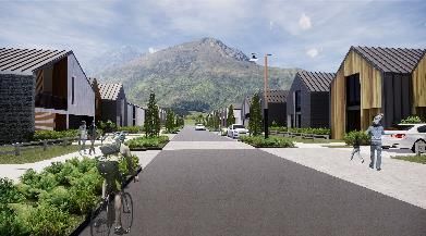
7 PROPOSED SUSTAINABLE TRANSPORT CONNECTIONS
7.1 Pedestrians and cyclists
North/south and east/west pedestrian permeability through the site, to the rest of the Ladies
Mile masterplan site and to wider destinations (eg Shotover/Lake Hayes Estate,
Frankton/Queenstown Airport, Queenstown CBD and wider recreational routes) will be
provided by the provision of the following facilities:
On Roads 1 to 6, 1.8m wide footpaths will be constructed on both sides (noting on
the Local Roads this is a greater width than QLDC CoP requirements). Footpaths
have been set at 1.8m on all roads to provide consistency in provision throughout the
site for pedestrians. Cyclists will ride on the road (in accordance with QLDC standards
the low volumes of traffic and low design speeds will make this safe and attractive to
cycle).
On private lane ways/JOALS, cyclists will ride on lanes (very low volumes of traffic
and low design speeds will make this safe and attractive to cycle).
3m off road shared use footway/cycleways provided at:
o Southern end of site within the landscape setback area plus connections from
Road 1.
o East of the site within the Linear Park.
o Through the Neighbourhood Park and connecting between Road 2 and
Lane F.
o The existing footpath at the SH6/Shotover Road/Lower Shotover Road
roundabout will remain. This will be provided adjacent to SH6 and widening
of the existing footpath (to allow for walking and cycling) within the adjacent
berm area is proposed. By providing this link, a continuous walking and
cycling route will be provided from the Flint’s Park site (via Spence Road,
Queenstown Trail and Connector Trails) to the Five Mile Shopping Centre
(circa 4.5km/ 14 minute cycle travel time), Queenstown Airport (circa 6.5km/
20 minute cycle travel time) to the Remarkables Shopping Centre/Frankton
(circa 7.5km/ 23 minute cycle travel time) and Queenstown CBD (circa
12.5km/ 38 minute cycle travel time) from Flint’s Park. Noting a ‘beginner’
average cycle time of 20km/h has been assumed.
As described in the Travel Plan (see Section 7.3 below), it is proposed that each
property will be given a free electric bike (ebike). This will reduce the cycle journey
times described above to circa 9 minutes to Five Mile Shopping Centre, 13 minutes
to Queenstown Airport, 15 minutes to Remarkables Shopping Centre/Frankton and
25 minutes to Queenstown CBD (using an assumed average ebike speed of 30 km/h
for a maximum electric motor of 300W permitted in New Zealand noting that
maximum speed cut outs are typically 37km/h-40km/h). These journey times are not
significantly greater than the free flow car journey time of circa 17 minutes to
Queenstown CBD. Peak period congestion (as evidenced in the QLDC ITA) would
bring the peak period ebike and car journey times much closer together.
Furthermore, ebikes allow the rider to reach their end destination without the need
for changing/shower facilities and are considerably easier/cheaper to park. Ebikes
also have a wider appeal for potential users as it is not necessary to be a ‘lycra clad’
athlete to undertake these types of journeys.
107.2 Bus At this stage it is not known what the bus route network will be through the whole Ladies Mile masterplan development. As such both of the proposed East West links (Roads 1 and 2) have been designed as Collector/Connector Roads which will safely accommodate buses (see Section 9 below). Bus stops could be provided on both or one of the Collector/Connector Roads (Roads 1 and 2) once the bus routes are confirmed by QLDC. Bus stops will be positioned to provide easy (
8    COMPLIANCE WITH RELEVANT TRANSPORT POLICIES
In 2018 QLDC, Otago Regional Council and NZTA signed a Memorandum of Understanding
to formalise a collaborative approach to addressing transport challenges within
Queenstown.
Key national, regional and local transport polices and strategies that the Flint’s Park proposal
complies with includes:

Government Policy Statement (GPS) 2018 - focused on four key priorities; safety, access,
environment, and value for money. The four categories have been developed to reduce
Deaths and Serious Injuries (DSI’s), deliver the best infrastructure for the right cost, provide
increased access for people and reduce adverse effects on the climate.
To reduce deaths and serious injuries, governing bodies will need to have a greater focus
on safety improvements on high risk state highways, such as SH6 in Queenstown, as well
as local roads.
The second priority of the GPS is access, with increased investment in footpaths and
cycleways to encourage uptake of active travel modes. The Flint’s Park development
focuses on facilities for active travel modes. The strategic vision looks at an increased focus
in urban centres and development in thriving regions, such as Queenstown. There is a
direction to support national freight and tourism connections, as well as integrating transport
and land use planning, which increases access to employment, education and recreation.
The policy statement also seeks to protect the environment in relation to land transport, with
mode shift to help aid in lowering emissions to facilitate the wider commitments of the
Government such as achieving the Paris Agreement 2030 GHG emissions target. It notes
the importance of creating liveable cities through enhanced public spaces and improved
accessibility. The Flint’s Park development achieves this through provision for bus and
active travel modes. The final priority is around investing in value for money projects which
consider the full range of costs and benefits over the whole life of the investment.
Otago Southland Regional Land Transport Plans (OSRLTP) 2015- 2021 (and proposed
variations Dec 2017 - out for consultation at the time this report was produced). The Otago
Southland RLTP was produced jointly between Otago and Southland Regional Transport
Committees to help acknowledge shared challenges and opportunities within the regions.
The long-term goal is a transport system in Otago and Southland that provides adequately
for mobility, economic activity and productivity while minimising road trauma. For urban
areas, including Queenstown, the OSRLTP seeks to reduce reliance on the private motor
vehicle, especially for shorter trips. It supports integrated transport planning and providing
transport for future requirements in addition to the present.
The plan encourages future development and subdivisions, such as Ladies Mile, to be
effectively served by public transport and active modes, reducing the demand on the road
network. Public transport should run on a regular basis and connect nodes to a centre with
essential services. It should also be accessible with adequate bus stops, shelters and
footpaths for people to access the services.
Provision for active modes must be incorporated into new designs and major improvements.
This can be by reallocating road space, delivering separated paths and priority for

                                                 12
pedestrians and people on bikes. The SH6 Ladies Mile Corridor improvements are included
in the OSRLTP where top priority projects proposed for 2018-2021 include:
New roundabout at the intersection of SH6 and Howards Drive.
One pair of bus stops on SH6, location to be confirmed.
SH6 pedestrian/cycleway underpass near bus stops.
Footpaths along SH6 to the underpass and bus stops.
Queenstown District Lakes Operative District Plan (OPD) (June 2018 updates). The
Operative District Plan recognises the need for a sustainable, safe transport system that
provides maximum choice between modes. The unique nature of transport demands and
constraints in Queenstown mean that land use and access need to be controlled efficiently.
Objectives 6 and 7 within the District Plan refer to recognising and meeting the needs of
people who travel by active modes and public transport. Detailed specific considerations
include:
Section 7.5.5.2 iii) identifies a minimum set back from a road boundary of 4.5m.
Section 10:
10.1.1 ii) Efficient Use of buildings and Infrastructure makes reference to “efficient and
safe routes for movement of people”.
10.1.13 Objective 1 refers to “providing a choice of transport mode” and providing a
“convenient link between employment and living environments”. Objective 5 refers to
making Queenstown town centre accessible to people including promote and
investigate opportunities for public transport linkages.
Section 14, Objective 1 classifies SH6 Ladies Mile as an Arterial Road, being a “dominant
element of the network connecting the major settlements in the District with the District” and
that it “will be managed to minimise its local access function”. The proposed SH6/
Howards Drive roundabout access is an existing intersection and as such this minimises its
local access function. Furthermore, the proposed construction traffic access does not result
in an additional access onto the existing SH6 thus minimising its local access function.
The Flint’s Park development is shaped and informed by the OPD and contributes to the
OPD stated objectives.
TYPE PROVISION GUIDANCE
QLDC Housing Infrastructure Fund (HIF) Business Case and Integrated Transport
Assessment (ITA). The HIF bid recognised that car dependent development is not
sustainable into the future as there is very limited opportunity to increase highway capacity
in an affordable way. All recently undertaken or planned Queenstown Transport Studies
include improvements to public transport and active travel, to improve the attractiveness and
reduce the use of private vehicles.
QLDC - Queenstown Integrated Transport Programme Business Case (QITPBC)
(2017) and Overarching Transport Programme Business Case (2017). Includes
Objective 1: To improve network performance for private vehicles, public transport and
cycling and Objective 2: Improved liveability and visitor experience. The QITPBC identified
the Ladies Mile Corridor Improvements as a key project and a good strategic fit with the
overall network improvements planned by the PBC.
13Park and ride public transport services are also recommended in the QITPBC. This included
the provision of parking facilities at appropriate locations (such as Frankton, Ladies Mile,
Jacks Point, Arrowtown/Arrow Junction) to enable greater use of public transport. The PBC
identified the importance of public transport at Ladies Mile in the overall integrated network
programme and funding from the NLTF at the 51% FAR rate would be expected for the bus
stops and underpass.
QLDC - Public Transport Demand Capacity Analysis. It is understood that this analysis
has been carried out to understand the demand for public transport across Queenstown and
the capacity of proposed solutions.
QLDC Frankton to Queenstown Single Stage Business Case (SSBC). Proposes
increasing capacity on SH6A with priority for public transport and intersection improvements.
Wakatipu Active Travel Network Detailed Business Case (DBC). Sets out strategic
active mode links to be integrated with other planned transport improvements and studies.
The proposed active travel mode Flint’s Park proposals support this DBC.
QLDC Parks and Open Space Strategy 2017. This document indicates that open space
should be distributed to create a contiguous network where possible that establishes
recreational trail networks, cycling and walking linkages. Connections or linkages can also
make moving around neighbourhoods easy, and can provide an alternative and sustainable
mode of transport. When new developments are planned they should connect with existing
trails and reserves where possible. All residents within urban/built up areas should live
within reasonable walking distance to a Local Park. Pathways to the reserves should be
easy for parents with young children, people with limited mobility and the elderly. For a
reserve to be ‘accessible’ it should generally be within 600m (an easy 5 to 10 minute walk)
of a property it serves and easily and safely accessible by foot. The Flint’s Park development
complies with these requirements.
149 INTERNAL ROAD LAYOUT AND COMPLIANCE WITH STANDARDS
9.1 Proposed road layout (see Appendix B for layout and Appendix D for typical
street designs)
Vested Roads
Road 1 – Collector/Connector Road - east/west route 15m road reserve with the following
cross section from north to south:
0.4m berm from property boundary to back of footway.
1.8m footway.
2.4m indented parking.
7m road.
2.4m indented parking.
1m berm to landscape buffer.
Total = 15m.
Road 1 width is future proofed to accommodate bus movements should this in the future be
the bus route. On street parking is provided on both sides of the street. Cyclists have the
option to ride on the road or, in likely the case of less confident or recreational cyclists, on
the parallel segregated footway/cycleway to the south of Road 1.
Road 2 - Collector/Connector Road - east/west route, 18m road reserve with the following
cross section:
1.3m berm from property boundary to back of footway.
1.8m footway.
2.4m indented parking.
7m road.
2.4m indented parking.
1.8m footway.
1.3m berm from property boundary to back of footway.
Total = 18m.
Road 2 width is future proofed to accommodate bus movements should this in the future be
the bus route. On street parking is provided on the south side of the street and partly on the
north side (none proposed parallel to the Neighbourhood Park). Cyclists will ride on the
road.
Roads 3, 4 and 5 – Local Roads - north/south routes, 18m road reserve with the following
cross section:
1.8m berm from property boundary to back of footway.
1.8m footway.
2.4m indented parking.
6m road.
2.4m indented parking.
1.8m footway.
1.8m berm from property boundary to back of footway.
Total = 18m.
Cyclists will ride on the road.
15Road 6 – Local Road - north /south route, 14m road reserve with the following cross section
from west to east:
1.8m berm from property boundary to back of footway.
1.8m footway.
2.4m indented parking.
6m road.
2m berm to Linear Park.
Total = 14m
No Stopping At All Times (NSAAT) road markings will be provided on the east side adjacent
to the Linear Park. Cyclists will ride on the road or on the Linear Park shared route which
runs parallel to the Park.
Private Laneways/JOAL’s
Typical lane widths will be 8m.
9.2 QLDC Masterplan proposed 3rd Collector/Connector East/West Road
The QLDC indicative masterplan identified a 3rd east/west collector/connector road in
between the proposed Roads 1 and 2. This is not proposed within the Flint’s Park proposal
for a number of reasons including:
The Flint’s Park proposal via Roads 1 and 2 provides a direct and convenient
pedestrian, cycle, bus and car connection to the proposed Local Centre without the
need for an additional 3rd Collector/Connector Road.
Provision of a 3rd collector/connector road as shown on the QLDC indicative
masterplan would not comply with the QLDC CoP (paragraph 3.3.7 Intersection and
alignment) 150m minimum intersection spacing.
The final form of the Local Centre is as yet unknown and hence it is difficult to confirm
whether this 3rd east/west road would be required. However, from an urban design,
public realm and pedestrian/cycle connectivity viewpoint, having the 3rd east/west
route aligned through the centre of the Local Centre Plaza would create additional
conflicts and barriers for pedestrian permeability around the Local Centre.
Provision of the 3rd east/west road produces very short block lengths (circa 80m)
resulting in an inefficient layout that would unnecessarily reduce the potential for
much needed housing.
9.3 Road layout compliance with QLDC standards
The QLDC Land Development Code of Practice (CoP) provides details of the standards for
land development and subdivision infrastructure. For Flint’s Park the QLDC land use
category of Live and Play and area type of Urban (i.e. population of 50/ha (circa 18.5 houses
per ha) has been assumed. In terms of compliance with the CoP paragraphs this is
summarised below:
3.2.5 Network Connectivity - in accordance with the CoP, all properties are within
300m of a connector/collector road.
3.2.8 Vesting – Roads 1 to 6 will be vested.
C3.3.1 Rear Access Lanes – all proposed Lanes A to H comply with CoP carriageway
types (a) and (b).
16 3.3.1.3 On street parking – each proposed indented parking bay is proposed to be
2.4m as opposed to the 2.5m in the CoP requirements. It is considered that this
non-compliance will have a negligible impact and is considered an acceptable width.
Table 3.2 Figure E20 Lanes, servingon the masterplan at the cul de sac on Lane H, and also elsewhere to improve connectivity
to the Neighbourhood Park, Linear Park and the SH6 Ladies Mile landscape area.
Vehicle Crossings - QLDC Operative District Plan (June 2018 update) Section 14.2.4.2
Access – at this stage detailed design has not been carried out on an individual unit basis
but the access design standards are noted and will be complied with.
1810 PARKING PROPOSALS AND COMPLIANCE WITH STANDARDS
10.1 Onsite Parking
QLDC Operative District Plan (June 2018 update) section 14.2.4.1 (i) Table 1 indicates the
following minimum onsite parking spaces for residents and visitors:
2 per residential unit.
1 per residential flat.
As detailed in Section 5.3 above, the development complies with these parking standards.
10.2 On street parking
The masterplan indicates circa 125 indented on street parking spaces will be available for
the 151 residential units. This is marginally less than the requirement of one on street
parking space per residential dwelling required by C3.3.6 of the QLDC CoP. It is considered
that this parking requirement is excessive taking into account:
National, regional and local transport policy prioritising modal shift away from car use
to active modes and bus.
Given the excellent walk, cycle and bus connectivity available to Flint’s Park
residents it would be inappropriate to provide excessive parking standards in this
location.
Therefore, it is considered that the amount of on street parking provided is appropriate for
this development.
10.3 Parking dimensions
QLDC Operative District Plan (June 2018 update) section 14.2.4.1 (x) indicates the following
residential onsite parking dimensions:
Single space = 3.1m width, 5.5m depth.
Double space = 5.6m width, 5.6m depth.
At this stage detailed design has not been carried out on an individual unit basis, but the
onsite parking design standards are noted and will be complied with.
1911 CONCLUSIONS
The proposal complies with relevant QLDC District Plan and Land Development Code
of Practice policy and design standards.
The development generally complies with the QLDC indicative Ladies Mile
masterplan.
This TA does not specifically consider the transport impacts beyond the site and has
adopted the findings and recommendations from the QLDC ITA.
In advance of NZTA delivering the SH6/Howards Drive, a construction traffic access
can be provided off SH6 to access the site initially.
The site provides excellent sustainable transport links for residents with an easy walk
and cycle distance to onsite local centre and Parks facilities and easy cycle and bus
journey times to nearby employment, education, shopping and other key services.
The development supports and complies with national, regional and local stated
sustainable transport strategy/objectives.
As such, it is concluded that the development is generally in accordance with the
ODP, that with the proposed transport measures then any potential transport effects
are minimised to a point which is acceptable and as such there are no transport
reasons that would preclude the development of the Flint’s Park site as proposed.
2012 APPENDICIES
A. QLDC indicative masterplan for the wider Ladies Mile
B. Flint’s Park masterplan
C. Site Location
D. Typical Street Designs
21Appendix A – Flint’s Park Proposed SHA Laid over QLDC Ladies Mile Masterplan
Road 2

                                                         Road 3

                                                                  Road 4

                                                                                    Road 5

                                                                                             Road 6
                                                                           Road 1

Appendix B – Flint’s Park Masterplan with Road Numbers
Regional Context
The site is located on the north side of
Arrowtown Ladies Mile approximately half way
between Queenstown and Arrowtown.
Queenstown Airport is located 5km from
the site, while the various commercial
developments in the Frankton area
provide convenient local shopping and
services.
The site is located on Ladies Mile (SH6),
which provides an opportunity to link into
key public transport routes between
Arrowtown, Lake Hayes Estate/Shotover
Country and the Frankton transit hub and
Queenstown central.
Five Mile/Shotover
Park
Remarkables
Park
Queenstown
CBD 0 20km
Lake Wakatipu
0 2.0km
Site Location -Flint Park SHA
Appendix C – Flint’s Park Site LocationTypical Street Designs
Road 1 Road 2
Roads 3, 4, 5 Road 6
Roads 3, 4, 5 Road 6
Appendix D Flint’s Park Typical Street DesignsYou can also read