"Accessibility Map" and "Social Navigator"
←
→
Page content transcription
If your browser does not render page correctly, please read the page content below
_______________________________________________________PROCEEDING OF THE 15TH CONFERENCE OF FRUCT ASSOCIATION

           “Accessibility Map” and “Social Navigator”
             Services for Persons with Disabilities
                       Kirill A. Kulakov, Yury A. Apanasik, Anton I. Shabaev, Irina M. Shabalina
                                           Petrozavodsk State University (PetrSU)
                                                      Petrozavodsk, Russia
                               kulakov@cs.karelia.ru, {apanasik, ashabaev, i_shabalina}@petrsu.ru

     Abstract—The paper describes development process of                x “Accessibility      Passports”:    web-service       for
 information environment for persons with disabilities.                   preliminary collection of accessibility data of socially
 Introduction describes the aim and objectives of development,            significant objects;
 the results of evaluation of typical demands and user scenarios
 for persons with disabilities. The first section of the main part      x “Accessibility Map”: mobile service for cartographic
 describes common applications architecture and utilized                  visualization of information about social facilities
 technologies. Both services use the same data model, which               categorized by accessibility levels and types of
 includes description of route parts and roads, as well as
                                                                          disability;
 information about accessibility of objects stored in the
 database of “Accessibility Passports” service developed                x “Social Navigator”: mobile route planning service
 previously. The next section contains description of the                 adapted for abilities of persons with various
 development process. The user scenarios, service functions,
                                                                          restrictions.
 the use of Geo2Tag platform and Open Street Map with its
 libraries are presented. In “Social navigator” service the              Standard navigation solutions for mobile devices are not
 routes are described as a graph with weighted edges, where          friendly enough for persons with disabilities because they
 the weight is the rate of accessibility of the path parts. The      provide uniform solution without taking into account
 mathematical method for estimation of accessibility according       disability restrictions. “Social navigator” is able to make
 to various types of ability restrictions was developed and          journey planning considering individual restrictions of a
 implemented in the service. The method is based on graph            person. In addition to the journey planning, the service will
 theory and provides an approach to formal ranging of the            provide functionality for collecting user feedback regarding
 routes according to the accessibility level of persons with
                                                                     conditions of a route. Such information can be summarized
 limited mobility.
                                                                     and provided to relevant authorities to help improving the
                        I. INTRODUCTION                              infrastructure for persons with disabilities in the most
                                                                     demanded areas.
     This work is a part of long-term project [1] related to
 development of information environment for persons with                Section II describes interaction between the services,
 disabilities. The aim of the project is to improve quality of       data storages and users. It includes information model,
 life of persons with disabilities by addressing issues related      high-level system architecture and used data objects.
 to social exclusion, accessibility and mobility of disabled         Section III describes “Accessibility map” mobile service.
 people by means of advanced ICT.                                    Section IV describes “Social navigator” mobile service, its
                                                                     architecture and functions, route accessibility estimation
     Presently the infrastructure of some cities in Russia is        algorithm, user ratings and obstacle promotion approaches.
 not friendly for persons with disabilities. Selection of a
 route to some socially significant facilities is challenging                      II. GENERAL SYSTEM OVERVIEW
 for a person with disabilities as information on accessibility
 of those facilities is not available. This lack of information      A. System architecture
 makes visit to the social facility somewhat risky, and it              The high-level architecture of the system is presented in
 means that the person can’t fully participate in the life of        Fig. 1. The description of each element is given below.
 the community.
                                                                        The “Accessibility Passports” service [1,2] manages and
     In order to increase the accessibility of facilities for        provides information about social facilities (hospitals,
 persons with disabilities a development of information              social centers, etc.) under the unified criteria and binds it to
 infrastructure was proposed. The work described in the              geographical coordinates. For regular users the service is
 paper was targeted to develop the following system of               available in read-only mode, but government authorities
 services and supporting modules:                                    and administrators may add and update information via
                                                                     web-interface. A special software agent converts the data to

                                                            ISSN 2305-7254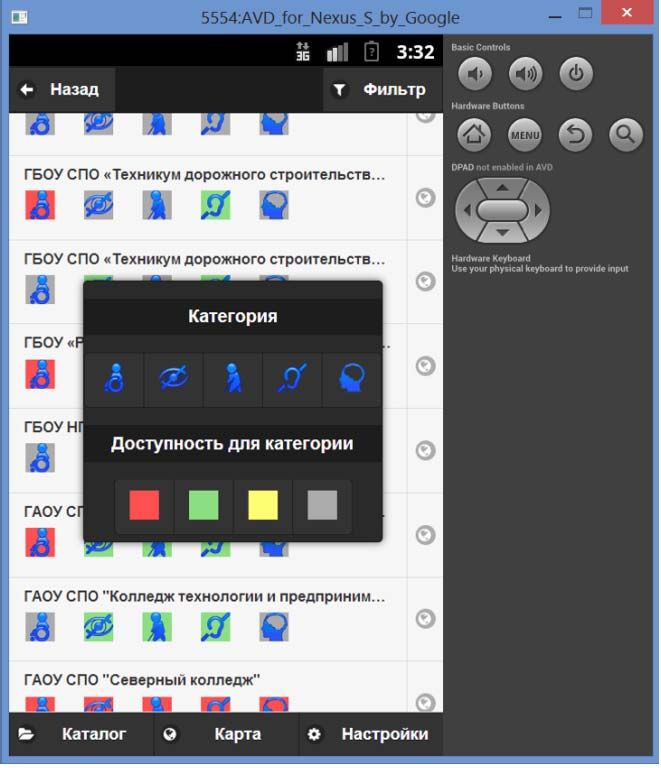
_______________________________________________________PROCEEDING OF THE 15TH CONFERENCE OF FRUCT ASSOCIATION

 geo-tags for the Geo2Tag LBS platform [3,4]. Geo2Tag                                      x Information of social objects accessibility is
 permits access to data about social facilities in given                                     collected by local authorities with “Accessibility
 coordinate areas for route planning, search queries, and                                    Passports”       service.     Also      accessibility
 displaying by means of cartographic services.                                               information about common objects (malls,
                                                                                             shops,      restaurants,    cafeterias,     cinemas,
                                                                                             entertainment centers etc.) can be gathered by
                                                                                             the service users.
                                                                                           x Current road conditions information is collected
                                                                                             by volunteers and members of community-based
                                                                                             organizations. The data should be moderated by
                                                                                             an automated system based on rating models.
                                                                                           x The services data can be completed by
                                                                                             estimations and comments provided by users.
                                                                                             Such information increases reliability and
                                                                                             relevance of the data. The user has an
                                                                                             opportunity to confirm/deny/append content
                                                                                             related to the visited place or used route.
 Fig. 1. System architecture
                                                                                       The government authorities present the most reliable and
     The “Social navigator” and “Accessibility map"                                 official information on location and accessibility of social
 services utilize data from “Accessibility Passports”                               objects. This information is stored in “Accessibility
 transformed to geo-tags.                                                           Passports” database and can be used in route planning
                                                                                    application without any moderation. The information
    Geo2Tag-based LBS service consists of Geo2Tag LBS                               gathered by organizations situated on social facilities and
 platform [3] and GeTS service [5]. Geo2Tag is used as                              community-based organizations should be verified before
 storage for various objects and GeTS service provides                              presentation on the map or usage for route creation. The
 functionality and application programming interface [6].                           mathematical rating models should be employed to increase
 Geo2Tag platform was effective employed in development                             the reliability of user-provided information.
 of applications related to healthcare and medical support [7,
 8, 9]. Typically location-based service provides two types                            “Social Navigator” service should process and utilize all
 of information: read-only public data and private data.                            types of information from different sources.
 Public data aggregates verified and trusted information. The
                                                                                                                      Objects accessibility
 private space is used for storing found obstacles, which are                               Authorities                  information
 not yet verified. The information from location-based
 service can be reused in other Geo2Tag-based services and                                  Accessibility
 applications.                                                                               passports

    Mobile application presents accessibility information for                                                                         Social
 target places and provides navigation functionality. If a user                           Social facilities                          Navigator
 finds a new obstacle along the route, then the information
 about the obstacle can be stored in his/her private space.
                                                                                         Community-based
    The web interface provides administration console for                                                               Road
                                                                                           organizations
 social services, government and administrators. Also web                                                           information
 interface provides access to functions of the "Accessibility
 map" service.
                                                                                               Users                 Assessments and
  B. The information model of the services                                                                              comments

    One of the key issues of the services is to collect                                    Rating model
 information provided by different types of users: persons
 with disabilities, experts and employees of local social                             Fig. 2. The information model of the services
 authorities, members of community-based organizations,
 ICT experts, volunteers etc. The common informational                              C. Data objects
 model of the services is shown in Fig.2.                                              An important part of the "Social Navigator" service is
      The information can be presented in the following ways:                       organization of data storage. The common data objects are
                                                                                    shown in Fig. 3.

----------------------------------------------------------------------------   70              ----------------------------------------------------------------------------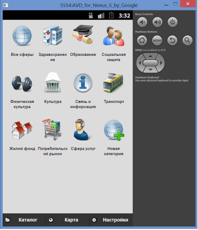
_______________________________________________________PROCEEDING OF THE 15TH CONFERENCE OF FRUCT ASSOCIATION
III. INFORMATION SERVICE “ACCESSIBILITY MAP”
A. Description of the service
“Accessibility map” service provides well-structured
information on accessibility level of socially significant
facilities, including the following items:
x name of the object/organization;
x description of organization activity;
x description of routes to an object;
x accessibility information related to the types of
disability;
x estimation and comments provided by users who
have visited the facility.
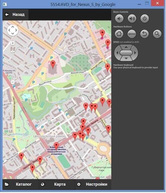
All organizations are grouped by activity (see Fig. 4). The
categories are healthcare, education, social care, sport,
Fig. 3. Data objects culture etc. This list can be extended. Two means of
visualization are available in the service: a categorized list of
For navigation algorithm it is required to know start and objects (Fig. 5), and a map with geo-tags (Fig. 6).
end points, road graph and complexity factor for each road Accessibility level of an object in the list is marked by color.
section. Start and end points and the list of disability types Also search and filtering features have been implemented.
are specified by user. Road graph is taken from
OpenStreetMap service [10]. The complexity factor is
calculated using obstacle properties. The nearest obstacles
are stored in Geo2Tag service and available via GeTS
service (see Fig.3).
The main problem of storing obstacles in Geo2Tag is
that Geo2Tag is a unified platform, which contains 2
entities: Channels and Tags. The Channel is a serial list of
Tags. Each Channel is specified by its name and
description. Each Tag is specified by its name, coordinates
and URL. Therefore, an obstacle must be specified in
Channel and Tag fields.
The GeTS service provides the following format of data.
Each Channel name contains data format prefix (e.g. points,
tracks, polygons) and Channel description contains packed
description and data type (e.g. audio tracks, images,
attractions). For obstacles it is required to use points format
and provide data types for all disabilities. Also obstacles
should be divided into permanent and seasonal. Each Tag
name field contains packed short name and difficulty level.
The navigation algorithm uses only points in Channels
corresponding to person disabilities. The private space is
organized using the same structure. Client application can
add disability information to the corresponding point in the
user's space Channel.
If start or end points are social facilities, the algorithm Fig. 4. “Accessibility map”: main screen
uses accessibility level for this point. If a social facility has
low accessibility level, any road from this point or to this
point has high complexity.
---------------------------------------------------------------------------- 71 ----------------------------------------------------------------------------_______________________________________________________PROCEEDING OF THE 15TH CONFERENCE OF FRUCT ASSOCIATION
The objects can be filtered by the following criteria:
x organization's activity: healthcare, catering, sport,
education, etc.;
x categories of persons with disabilities: “moving on
a wheelchair”, “hearing-impaired”, “visually
impaired”, etc.;
x levels of accessibility: “fully accessible”,
“conditionally accessible” and “inaccessible”.
The searching of objects is performed by name and/or
some key words.
The user can sort the list of objects by distance from
current location.
B. Service implementation
The architecture of the service is presented in Fig. 7. It is
based on the use of MVC (Model-View-Controller)
approach [11]. The Geo2Tag storage contains geo-tags for
the objects. Each geo-tag includes geographical coordinates
and information related to the object. The database MySQL
is also utilized to store information on registered users and
content from users, which is needed for rating model
implementation.
Fig. 5. “Accessibility map”: accessibility level configuration The program logic is implemented in WebAPI module.
It is a web-service, which receives http-queries in defined
format and returns the result in JSON format. WebAPI
module provides required list of objects, makes user
authorization and so on.
Mobile GUI and Web GUI modules share the same
logic, but the Mobile GUI is used for small mobile phones,
and Web GUI – for standard PCs and tablets.
Mobile GUI module is implemented using HTML5,
JavaScript and CSS3 technologies [12]. Also JQuery,
JQuery Mobile and AngularJS open source frameworks are
used, as well as mobile application development framework
PhoneGap.
Mobile Web
GUI GUI
WebAPI
Geo2Tag MySQL
Fig. 6. “Accessibility map”: objects on the map
Fig. 7. “Accessibility map” architecture
---------------------------------------------------------------------------- 72 ----------------------------------------------------------------------------_______________________________________________________PROCEEDING OF THE 15TH CONFERENCE OF FRUCT ASSOCIATION
Web GUI module was implemented using web solution because most of the city streets are not yet
application development framework ASP.NET MVC4. In prepared for persons with disabilities. In this case warning
practice, Web GUI controllers only provide access to of the problem places is very important for disabled people.
WebAPI functions of “Accessibility map” service [11].
B. Service architecture and functions
IV. “SOCIAL NAVIGATOR” SERVICE The "Social Navigator" service has the following main
A. Description of the service functions:
Unlike standard navigation solutions for mobile devices, x Route planning. The service uses current user
which are not friendly for persons with disabilities, “Social position, road graph and complexity factors for
navigator” service enables journey planning taking into each road section and provides optimal route
account individual restrictions of the user. The service also using the navigation algorithm. Optimal route is
provides functionality for collecting user feedback recalculated every time when the user moves or
regarding conditions of selected route. The information can changes the destination point.
also be forwarded to relevant authorities to help fixing x Off-line work. All required data can be
problems as soon as possible, or at least to inform other downloaded to the user device for off-line work,
users. Using traces of real trips, the service will enable a because Internet connection may be slow or
better planning of next journeys, e.g. by using the actual disabled during the trip.
travel time for the person with given restrictions. By x Report a new obstacle. The service allows saving
analyzing trip planning requests the service will discover information about a new obstacle, when it is
travel bottlenecks, i.e., unfriendly areas for persons with found. New obstacle is stored into user's private
disabilities that result in most inconveniences, e.g., need to space and can be copies to the public space
take longer alternative routes. Such information could also and/or shared with friends.
be summarized and provided to relevant authorities to help x Route sharing. The service allows sharing route
improving the infrastructure for persons with disabilities in between friends using social networks. The
the most demanded areas. shared route includes complexity estimations and
found obstacles.
Navigation solutions could be illustrated on the
following example, when the person with disabilities needs The high-level architecture is shown in Fig. 8.
to move from home to a hospital. The optimal route
depends on the type of disability and type of obstacles.
Each disability requires that information about each
obstacle is duplicated for other sensory organs. Each
obstacle increases time and complexity of the route and
may make the route impossible.
Assume for this example that short route from home to
the target place has several crossroads, stairs, direction
indicators, road defects and seasonal obstacles like
snowdrifts. If the person is blind, then most of traffic lights,
stairs and road defects are not a critical problem, but using
uncontrolled crossroads and walk throw seasonal obstacles
increases complexity of the route and requires increased
attention. Visual direction indicators without duplication to
other senses make the route impassable. Fig. 8. “Social navigator” architecture
For the deaf-mute persons all obstacles are passable, but
some obstacles require increased attention. The user interface includes the following modules:
For persons with physical disabilities most of obstacles x MapFragment for displaying the map. It supports
are also passable, but may increase complexity of the route on-line and off-line modes.
and in the worst cases (like high stairs without rampant) x PointsFragment for browsing nearest social
make the route impassable. facilities. The list of social facilities supports
user filters.
Thereby the problem of finding the route requires full x DetailFragment for getting more information
information about all obstacles including seasonal obstacles about the point of interest. In this module user
and the list of disability types. Unfortunately, full can briefly connect to on-line databases like
information about all obstacles does not always provide a Wikipedia.
---------------------------------------------------------------------------- 73 ----------------------------------------------------------------------------_______________________________________________________PROCEEDING OF THE 15TH CONFERENCE OF FRUCT ASSOCIATION
x OnlineContentFragment is used to download off-
1
line data to the application storage.
= ,
DirectionService module calculates optimal routes to
target point synchronously. It uses the navigation algorithm
from GraphHopper library [13]. Also the complexity where – an assessment of user of the edge for
factors for all nearest road sections are calculated in this category of disabled person, ∈ [0; 1], =
module. 1, … , , = 1, . . , , = 1, . . .
PointsManager is used for asynchronous communication The weights of edges can be defined as follows:
with “Accessibility Passports” service and other public
services that provide information about the target point. = ∙ 1 − ,
> 0;
GeTS module implements application programming = ∙ 1 − ln
,
> 0;
interface for GeTS service. This module authenticates the
user via Google Auth service, if it is requested. The module = ∙ exp1 −
,
also downloads information about a group of nearby
obstacles and uploads information on the nearest found where = 1, … , , = 1, . . , .
obstacle to the user's private space.
All these approaches increase weight of an edge with
RemoteStorage module is used for downloading archives low level of accessibility and reduce it to distance , if
with off-line data. The list of available downloads is stored = 1.
in GeTS service. The module uses gzip compressing, and
integrity control with sha1 algorithm. The optimal route for category of disability is defined
with:
The service uses the following external libraries:
x graphhopper – navigation library [13]. The
! = ":
# = min ()$,
∈
library uses road graph from OpenStreetMap
service. where () = ∑& – length of route for category
x Osmdroid – library for showing OpenStreetMap = 1, . . , .
maps [14]. It is used in on-line mode together Currently the algorithm is being elaborated and tested.
with MapQuest Open service and in off-line
mode together with mapsforge library. D. Ratings and promotion
x Mapsforge – library for rendering maps and The common problem of Social navigator service is data
generation map tails [14]. reliability. The simple way is to gather data for public
x Simple XML – library for parsing XML data usage by project members, but technically it's hard to
[16]. It is also used for working with GeTS implement, because the amount of data is very large.
service. Another way is to provide regular user a possibility to add
data. In this case the core problem is user’s confidence.
C. The route accessibility estimation algorithm
The proposed solution is to divide all users into groups,
The “Social Navigator” service uses accessibility
add corresponding possibilities and restrictions for each
estimation algorithm based on subjective user assessments
group and use rating system for moving users between
extended to a mathematical model for evaluation of routes
groups (see Fig. 9.).
accessibility for each category of persons with disabilities.
In general, "Social Navigator" service users can be
Let us denote – a set of not coincident routes
divided into the following 3 groups:
connecting two geographical points A and B. The set is
defined on a graph (, ), where - a set of nodes x Administrative group. Each user in this group
(geographical points), – the set of edges connecting the can manage public data and other users. Project
nodes. The route ∈ contains edges with management is a common part of administrative
corresponding distances between graph nodes, = group. Users in this group have high trust level.
1,2, … , . x Trusted group. This group includes members of
community-based organizations, volunteers and
Let's denote a value of accessibility of edge for
so on. The trusted group can provide data for
category as:
public usage automatically.
x Regular user. This is a largest group, which
includes all registered and anonymous users.
---------------------------------------------------------------------------- 74 ----------------------------------------------------------------------------_______________________________________________________PROCEEDING OF THE 15TH CONFERENCE OF FRUCT ASSOCIATION
At this stage of development, the main difficulty is
making strategically correct decisions regarding the
program architecture of services, the information models
and utilized technologies.
The information is provided by authorities, volunteers
and other users. “Accessibility Map” and “Social
Navigator” service use the same data model, which
includes description of route parts and roads and objects
accessibility information. The main aim of the services is to
provide the required information on social objects and
routes to the users with various types of restrictions. The
functions are developed by means of Geo2Tag LBS
platform and Open Street Map.
Fig. 9. Private data promotion
“Accessibility map” service provides well-structured
information on accessibility level of socially significant
Users in regular group can add obstacle or other data
objects.
into the private space. This data can be used by this user or
shared with friends or other people, e.g. via social network. In “Social navigator” service the routes are described as
a graph with weighted edges. The weight is the accessibility
If a regular user finds an obstacle, which should be
rate of path parts. The mathematical method for estimation
known by other persons, he/she can promote this obstacle.
of routes accessibility is based on user assessments and
If this obstacle is really important, a member of
implemented in the service. The method uses the graph
administrative or trusted group can accept it and add this
theory and provides approaches for formal rating of the
obstacle to the public space.
routes according to the level of accessibility for persons
Also each person can express his/her opinion by voting. with limited mobility.
The obstacle rating is calculated as a linear combination of
The “Social navigator” service uses user and obstacle
positive and negative votes and users ratings.
ratings for new data management. Any person can propose
To highlight important promoted obstacles, they are new information that may be accepted. Data from trusted
being rated. The user's rating is calculated as a linear group of users can be approved automatically. Also any
combination of accepted and rejected obstacles which user can share own data to other persons via social
he/she promoted. If obstacles are accepted by trust user or networks.
administrator, then each user, who votes positively,
Initially, the database is filled by the project team. After
increases the rating and each user, who votes negatively,
that information will be gathered via community-based
decreases the rating.
organizations, social volunteers and regular users.
Therefore we can rate also users. If a regular user has
high rating, he/she can be moved to the trusted group. Also ACKNOWLEDGMENT
if trusted user gets low rating, he/she can be excluded from This research is a part of grant KA432 “Journey planner
the trusted group. service for disabled people (Social Navigator)” of Karelia
ENPI programme, which is co-funded by the European
There are 2 nonstandard cases, which should be solved
Union, the Russian Federation and the Republic of Finland.
manually: when a trusted user provides non-existed
obstacle or accepts it, and when a trusted user rejects an The article was published with financial support of the
existing obstacle. In these cases administrative users can Strategic Development Program of Petrozavodsk State
verify this obstacle and change the decision. University.
V. CONCLUSION REFERENCES
At present the information infrastructure, which [1] Journey planner service for disabled people (Social navigator)
contains several mobile and web services, is being (KA432). Web: https://www.kareliaenpi.eu/en/themes/332.
[2] Y. Apanasik, I. Shabalina, A. Shabaev “Accessibility Passports”
developed. “Accessibility Passports” service has been Service for Information Social Infrastructure”, Proc. of the 14th
developed and put into operation by the Ministry of Conference of Finnish-Russian University Cooperation in
Healthcare and Social Development of Karelia. Currently, Telecommunications Program. Spb.: SUAI, 2013, pp. 3-8.
[3] Geo2tag: Open Source LBS Platform. Web: http://geo2tag.org.
the service database contains information on 450 socially [4] M. Zaslavskiy, K. Krinkin “Geo2Tag Performance Evaluation”,
significant objects with geographical coordinates and Proceedings of 12th Conference of Open Innovations Association
accessibility levels. FRUCT, SUAI, 2012, pp. 185-193.
---------------------------------------------------------------------------- 75 ----------------------------------------------------------------------------_______________________________________________________PROCEEDING OF THE 15TH CONFERENCE OF FRUCT ASSOCIATION
[5] Geo2tag e-Tourism service. Web: https://github.com/oss-fruct- for Electrocardiograms Analysis” Proceedings of 12th Conference
org/gets/wiki. of Open Innovations Association FRUCT, SUAI, 2012, pp. 14-19.
[6] V. Romanihin, M. Zaslavskiy, K. Krinkin “Spatial Filters [10] OpenStreetMap. Web: http://www.openstreetmap.org/
Implementation for Geo2Tag LBS Platform”, Proceedings of 11th [11] J. Smith, “WPF Apps With The Model-View-ViewModel Design
Conference of Open Innovations Association FRUCT, SUAI, 2012, Pattern”, September. 2012. [Online].
pp. 151-157. [12] W. R. Stanek Internet Information Services (IIS) 7.0
[7] A. Reyss, S. Balandin “Healthcare, medical support and Administrator’s Pocket Consultant. Spb: Russian Edirors, 2009.
consultancy applications and services for mobile devices”, IEEE [13] GraphHopper Road Routing in Java with OpenStreetMaps. Web:
Sibircon, Irkutsk, Russia, 2010, pp. 300-305. http://graphhopper.com/.
[8] I. Bezyazychnyy, K. Krinkin “Doctor Search Service. Using [14] osmdroid – OpenStreetMap-Tools for Android. Web:
Geo2tag LBS Platform for Mobile Healthcare Applications”, http://code.google.com/p/osmdroid/.
Proceedings of 12th Conference of Open Innovations Association [15] mapsforge – Free mapping and navigation tools. Web:
FRUCT, SUAI, 2012, pp. 19-25. http://code.google.com/p/mapsforge/.
[9] A. Borodin, A. Pogorelov, Y. Zavyalova “Overview of Algorithms [16] Simple XML Serialization. Web: http://simple.sourceforge.net/.
---------------------------------------------------------------------------- 76 ----------------------------------------------------------------------------You can also read