Activity centres lead the suburban recovery - Greater ...
←
→
Page content transcription
If your browser does not render page correctly, please read the page content below
December 2012 Newsletter published on behalf of the UDS partnership
Activity centres lead the suburban recovery
The post-quake exodus of commercial and retail businesses from the provide residents with convenient connections to Activity Centres.
central city to suburban locations around the city, and throughout
This issue of the UDS partnership newsletter looks in some detail at the
greater Christchurch, has exacerbated a trend that the Urban
planning and implementation of Activity Centre and other suburban
Development Strategy (UDS) has sought to better manage.
centre plans in CCC, SDC and WDC. In the CCC, the planning takes
As early as 2003, the UDS recognised the growth of commercial, retail the form of Suburban Centre Master Plans. Eight master plans are
and social service centres located in the suburbs. These centres, in various stages, of which four have been completed – Sydenham,
which the UDS calls ‘Activity Centres’, had grown up around major Lyttelton, Spreydon Shops and Linwood Village.
malls within Christchurch City – particularly Riccarton, Papanui/
The SDC has completed a round of consultation on its Rolleston
Northlands, Linwood/Eastgate, Shirley/The Palms, Hornby and
Town Centre Plan. Proposals include a greater mix of uses to support
Spreydon/Barrington. Similar Activity Centres were identified in the
the existing retail and community facilities, ensure good access and
primary towns of the Selwyn District (Rolleston and Lincoln) and in the
linkages both within the centre and to the wider town, and develop
Waimakariri District (Rangiora, Kaiapoi and Woodend/Pegasus).
a more pedestrian-friendly centre with a focal point for community
While there was concern that the growth of these suburban Activity gatherings.
Centres might undermine the vitality of the Central City, it was
The WDC has signed contracts for work to commence on the Kaiapoi
recognised that no amount of planning could turn back the clock, nor
Town Centre Plan with repairs and improvements to the Williams Street
was it necessary for people to conduct all their day-to-day business
Bridge and Williams Street north of the bridge. In Rangiora the re-
in the Central City. Projected population growth meant enlarged and
alignment of the High and Ashley Streets intersection has moved a step
enhanced Activity Centres would be required in the future in addition to
closer with the purchase of the Westpac Bank building on the northeast
a revitalised Central City.
corner. Improving this intersection is one key part of implementing the
In the aftermath of the earthquakes, many commercial and retail Rangiora Town Centre Strategy that the WDC adopted in 2010.
businesses relocated to these Activity Centres. Suburban centres
ECan has implemented changes to the Metro system that reduce the
weren’t immune to earthquake damage. Sydenham and Lyttelton were
number of services that currently travel into the central city, by re-
extensively damaged, forcing some of their businesses to relocate to
directing them to the closest Activity Centre, where passengers could
other suburban locations. While many relocated businesses are looking
transfer (at no cost) to high-frequency services travelling to the central
forward to returning to the Central City, other businesses have found
city and other Activity Centres. The NZ Transport Agency’s work to four-
that their operations or activities are better suited to Activity Centres
lane State Highway 1 will improve links from suburban centres such
and may not return.
as Rolleston and Rangiora to the Christchurch International Airport,
The drift of population from the eastern suburbs to the north, northwest critical for freight and the economy.
and southwest has reinforced the need for commercial, retail and
The planning and development of Activity Centres are a critical part of
community hubs at the Activity Centres in Selwyn and Waimakariri
implementing the UDS and also of assisting with the recovery. For many
Districts and in the outer-lying Christchurch suburbs of Belfast/
people simply being able to access local shops and services will be a
Northwood, Hornby and Wigram/Halswell.
significant improvement on how life has been over the past two years.
Consequently the Selwyn District Council (SDC) and Waimakariri As new suburbs grow on the City and District town fringes the need for
District Council (WDC), along with the Christchurch City Council shops and services within convenient travelling distance will increase.
(CCC), have all been revising and adapting existing, or developing This newsletter confirms that the UDS partners are ensuring the
new, Activity Centre plans to accommodate the growth in demand and development of new suburbs and Activity Centres are timed together to
anticipate future needs of residents using these centres. Environment ensure residents enjoy a better quality of life in Greater Christchurch.
Canterbury (ECan) has revised its Metro public transport services to
Bill Wasley
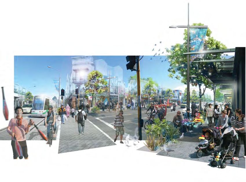
Artist’s impression, Sydenham Master Plan. Colombo, Byron and Sandyford intersection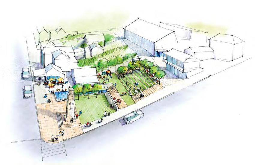
Kaiapoi town centre revival underway
Implementation of the Kaiapoi Town Centre Plan commences with repairs and improvements to the Williams Street Bridge and Williams Street north
of the bridge. By May 2013 water main and sewer mains will be replaced, kerbing and channelling replaced, some roading and footpath repairs and
landscape improvements associated with the town centre upgrade completed.
The severe damage of the September 2010 earthquake to the Kaiapoi Town Centre – its buildings, roads and other infrastructure – required an urgent
and co-ordinated approach to restoration and redevelopment. The Kaiapoi Town Centre Plan was developed in close consultation with the Kaiapoi
community, local businesses and other stakeholders.
Background investigation revealed a number of key issues, some not earthquake related. These non-earthquake issues included delays and safety
issues caused by high traffic flows along Williams Street, problems at intersections, inadequate car parking, town centre safety for pedestrians,
cyclists and restricted motorway entrances into Kaiapoi. Wider economic, environmental and cultural issues which impacted on the town centre
were declining retail activity and patronage, the loss of many heritage buildings, and the place of the Williams Street Bridge as a unifying focal point
between the northern and southern sides of the town centre.
The Waimakariri District Council adopted the Kaiapoi Town Centre Plan in June 2011. The Plan is based upon Williams Street, the ‘spine’ of the town,
including the Williams Street Bridge. Eight projects were determined:

1. The Williams Street Bridge – emphasise the river and enhance connections between north and            2. The (former) Bridge Tavern site – create a landmark attraction on northern riverbank
   south

3. Williams Street North redesign – an attractive street environment/public space on the north side of   4. Raven Quay West – an accessible riverside on the south bank of the river
   river to define the northern entrance

5. Williams Street South redesign – enhance street environment and define southern entrance               6. Street improvements - improve intersections, on-street parking and enhance street environment
7. Design principles for the western precinct – principles necessary for good urban design when 8. Concept Sketch of the Proposed Kaiapoi Library/Museum Complex
development occurs
The town has seen significant changes in its built environment since the earthquake and the adoption of the Kaiapoi Town Centre Plan. A brand new
supermarket has opened. The damaged Kaiapoi Library and Service Centre along the main street has been demolished and land remediation onsite
has begun to prepare for the rebuild of an improved service centre and community resource.
A new medical precinct and shops have been built, as has a brand new pub. Construction of the new building to house the town’s Blackwells
Department Store, which was severely damaged during the quake, will begin shortly, as will a new multi-storey commercial building on a corner site.
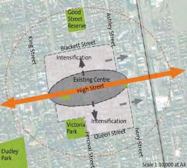
Rangiora Town Centre 2020
Implementation has begun on RTC2020, the Rangiora Town Centre Strategy, adopted by the Waimakariri District Council in September 2010.
High Street, the heart of the town’s retail and commercial activity, is the primary focus of the Rangiora Town Centre Strategy.
Rangiora is the largest urban area in the Waimakariri District with a population of 12,000 at the 2006 Census. The earthquakes of 2010 and 2011 and
the subsequent migration of people into the District mean the projected population of 16-18,000 for 2021 is likely to be exceeded.
The strategy was developed to address a number of key issues facing the town centre:
• Sustained growth in population
• Demand for retail/office space and community services
• Parking and traffic issues
• Limited protection of the traditional character of High Street
• Challenges from other nearby centres
A vision sets the long-term direction for Rangiora town centre - ‘a town centre which is sustainable, prosperous, vibrant, easily accessible, contains
safe and attractive pedestrian-orientated streets and spaces, with High Street at its heart in reflecting Rangiora’s unique character and identity’.
Providing for Growth
To ensure the town centre retains its compact and walking-friendly form,
intensification of town centre activity is proposed for the areas north and south of
High Street ensuring vitality and prosperity are concentrated and more retail and
office floor space made available.
Improving Access
The intersection of High Street and Ashley Street at the eastern end of the Rangiora
Town Centre has been the subject of community criticism for some time. The north/
south fast-moving traffic, cars trying to exit from High Street, and pedestrians is a
potentially fatal combination.
The strategy proposes to re-align and signalise the intersection and convert High
Street to two-way traffic (it is currently one-way in the centre of town) and replace the
current angle parking with parallel parking on both sides of the street.
Implementation has progressed with the Council purchasing the Westpac Bank
premises on the northeast corner, necessary for the re-alignment.
Intensification north and soruth of High Street
www.greaterchristchurch.org.nz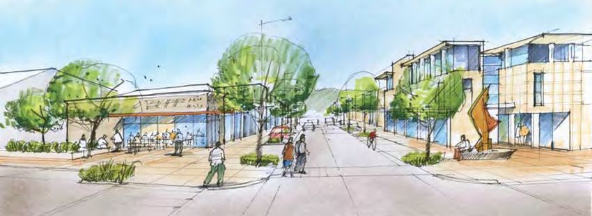
Improved signage and parking, as well as the construction of roundabouts along Queen
                                                       Street, to the south of the town centre, are aimed at balancing traffic flow around the town
                                                       centre perimeter with good access to its core.

                                                       Enhancing Character and Quality
                                                       The heritage character and scale of buildings along Rangiora’s High Street is one of the most
                                                       attractive features of the town centre. It is important this traditional character be maintained
                                                       and enhanced.
                                                       Changes to the District Plan (Plan Change 35), introduced since the strategy was adopted,
                                                       provide design guidance for new development in Rangiora’s centre, helping to maintain and
                                                       enhance the special attractive character of Rangiora.
                                                       The upgrade of current laneways leading from High Street north and south of the street could
                                                       lead to new retail and commercial development, with frontages that stimulate pedestrian
                                                       activity.
                                                       The upgrading of a block of land just to the north of High Street with improved pedestrian
                                                       linkages, new retail and office floor space, attractive public space and better parking will
High/Ashley Streets intersection                       complement existing buildings and shops. It also will encourage people to park away from
                                                       High Street, limiting congestion.
Although Rangiora didn’t appear initially to be as seriously affected by earthquake damage as Kaiapoi, building inspections throughout 2011
have resulted in a number of commercial buildings along High Street being closed. This has accelerated the North of High Street strategy project.
Discussions are being held with property owners to achieve a comprehensive approach to redeveloping this town centre area in a co-ordinated way,
rather than on an individual basis.

Entry/exit to Blake Street
                                                                                                                                          To High Street

North of High Street - concept plan
City Suburban Centres Programme moves up a gear
The Christchurch City Council has approved master plans for the rebuild and recovery of four suburban centres, including the Lyttelton and Sydenham
Town Centres, the Selwyn Street Shops and Linwood Village. A further four master plans are being developed for other suburban centres.
The earthquakes in 2010 and 2011 caused damage and disruption to about 60 commercial centres throughout Christchurch. The City Council is helping
these areas to recover through the Suburban Centres Programme.
Initiated in June 2011, the programme provides coordinated planning and assistance to help with the rebuild and recovery of commercial centres as
focal points for their local community. The programme recently reached a major milestone with the first four of eight master plans signed-off by the
Council.
Signs of recovery can already be seen in these centres, with pop-up cafes and art installations. The recovery will be further supported as the master
plans begin to be implemented.
Progress made:
• Eight master plans underway across the city.
• Council has adopted master plans for the recovery and rebuilding of the Lyttelton and Sydenham suburban centres, Selwyn Street Shops and
Linwood Village.
• Over 2500 people have been involved in focus group and community sessions to discuss the redevelopment and recovery of their local centres.
• The Council is spending $2 million this year for strategic land purchases arising from Suburban Centres Programme-related master plans.
• The Council has purchased the site at 44 London Street, Lyttelton, for the development of a new civic square, identified as a priority by the local
community in the Lyttelton Master Plan.
• Council case managers are working in suburban commercial centres assisting with site-specific planning matters and offering advice.
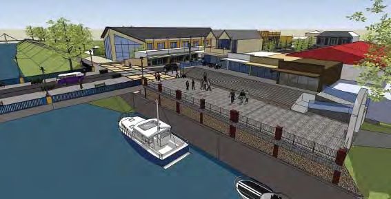
An artist’s impression of the Lyttelton Master Plan’s new civic square. The civic square design aims to provide more open space for community gatherings and performance, an innovative children’s playground
and a central site for the relocation of the Lyttelton War Memorial Cenotaph.
www.greaterchristchurch.org.nz
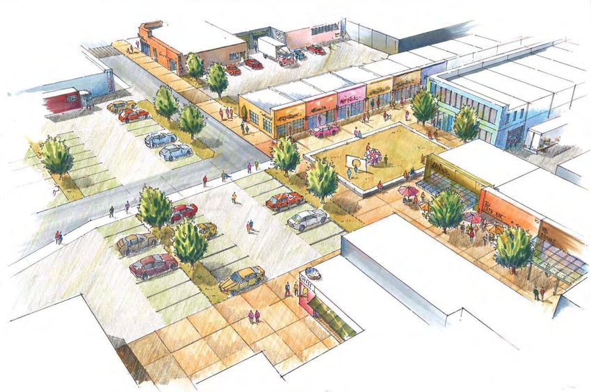
Linwood Village Master Plan – an artist’s impression of the redeveloped Linwood Village, viewed from the corner of Worcester Street and Stanmore Road looking west.

Master plan implementation steps
A master plan is a long-term, community-agreed vision of how suburban centres may look, feel and function. It provides a guideline for the
community so they can set goals and prioritise what they want to develop. This enables the Council to make decisions based on community priorities.
Some actions will be Council-led while others will be implemented by the private sector and through community initiatives. All actions require
funding and resources, which will take time.
The Council will need to complete detailed costings for the individual actions it is responsible for, so these can be included in the Council’s financial
planning processes such as the Long Term Plan and Annual Plan. While the timing of project roll out will be dependant on funding cycles, some
projects, such as street enhancements, may be advanced through the Council’s wider work programme and could potentially be integrated with the
SCIRT programme.
There will be further opportunities for people to be involved in the rebuild and recovery of their suburban centres as specific master plan projects are
progressed.

Who is working on the programme?
The Suburban Centres Programme has 10 urban designers and planners putting together the master plans – with much of the information coming
from the local community. For the Sumner Master Plan, the Council agreed to a community-led approach with a Joint Advisory Group.
The project teams look at historic planning documents and maps, previous studies and consultations, past and present land-use activities, economic
viability, transportation to and from the area, the design of streetscape and roads and recommendations for future planning.
Rolleston town centre faces transformed future
                                                                                                Rolleston residents have been having their say about
                                                                                                what they think the town centre should look like, as the
                                                                                                Selwyn District Council plans for exponential growth of
                                                                                                the town.
                                                                                                In September the Council held two drop-in days and sent
                                                                                                information seeking feedback on the future town centre
                                                                                                through the Council’s website, Facebook page (Future for
                                                                                                Selwyn) and feedback forms.
                                                                                                Over the next 30 years it is expected that Rolleston will
                                                                                                grow from around 8,000 people to between 18,000 and
                                                                                                22,000 people. The current town centre is dominated by
                                                                                                large format retail and car parking with poor connections
                                                                                                between them. Improvements to the town provide the
                                                                                                opportunity to:
                                                                                                • Introduce a greater mix of uses to support the retail
                                                                                                  and community facilities that exist.
                                                                                                • Ensure good access and linkages both within the
                                                                                                  centre and to the wider town.
• Develop a more pedestrian-friendly centre with a focal point for community gathering.
• Make it distinctive from other towns in the district and a desirable place to visit.
Following the collation and analysis of ideas, the Council will formulate options for the town centre, which will go out for public consultation around
the end of this year. A public hearing is scheduled for March next year, followed by preparation of the Master plan that the Council will consider in
May 2013.
People who want to find out more can visit www.selwyn.govt.nz/rollestontowncentre

Metro changes support recovery of suburban centres and the
CBD
Better meeting post-earthquake travel needs to suburban centres, and in time, the CBD, are the focus of improved Metro public transport services that
started on 3 December 2012.
The February 2011 earthquake had a significant impact on the Metro Network and more than 18 months later, patronage is still down approximately
30% compared to pre-quake levels. Even before the earthquakes, Environment Canterbury staff members were planning a new approach to providing
public transport in response to slowing patronage growth and cost effectiveness. The new model, beginning with the December changes, has been
dubbed “hubs and spokes” and recognises the importance of suburban centres while the central city is rebuilt.
The December changes are the first stage in a two-stage process to roll out a new way of providing public transport. The pre-quake network structure
had a heavy focus on the central city - almost all bus services ran there, the notable exceptions being the cross-suburban Orbiter and Metrostar
services. The new network will focus on better servicing suburban centres, but will maintain a strong core network of high-frequency services linking
suburban centres and the central city.
Many people only travel as far as their closest suburban centre, where they find all the facilities they need such as shops, banks, libraries and Council
Service Centres. Post-quake patronage statistics reflect these travel trends. Though overall use of Metro dropped significantly, the number of people
travelling to places such as Riccarton and Northlands has remained strong.
In future, instead of almost all bus services running to the central city, certain routes will run to their closest suburban centre. Passengers will then be
able to connect with high-frequency services that run to the central city, and also to cross-suburban routes to other centres. The bus stop and shelter
facilities provided at suburban locations will be gradually upgraded to reflect their increased importance.
These December changes represent the first stage of transition towards the hubs and spokes model and involve the north – south routes only. The
second stage is planned for no later than 2014/15, after feedback on stage one changes and consultation on stage two is considered and changes are
finalised.
Further information on the December 3 changes can be found at www.metroinfo.co.nz/preview/

                                                                                                                www.greaterchristchurch.org.nz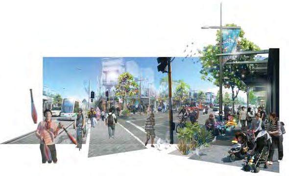
Multiple benefits from Upgrading Russley Road (SH1)
Easing congestion and improving safety are just two of the
benefits of four-laning Russley Road (SH1) past the Christchurch
International Airport. Improved access to business and residential
developments in the area, and taking traffic off the surrounding
local roads are two further benefits.
This project is part of the NZ Transport Agency’s Christchurch
Western Corridor improvements which will provide a four-lane
expressway from north of Belfast to Hornby. This part of the
project involves four-laning Russley Road between Ryans Road
and Harewood Road. The Russley Road/Memorial Avenue
intersection will be upgraded with an over bridge incorporating a
gateway structure.
Effective and efficient access to the airport is important to the
regional economy. Airport activity already generates a significant
amount of traffic that will continue to rise, with further industrial
and other developments in the area.
A southern access to the airport has now been investigated by
the NZ Transport Agency who has worked with key stakeholders
Memorial Bridge (viewed from the southeast)
to identify the best location and form. This will be through the
Dakota Park development and the NZ Transport Agency will be
applying for the necessary consents in the New Year. The northern
WESTERN CORRIDOR PROJECTS WESTERN access to the airport will be from Harewood Road with the new
BELFAST
BYPASS Russley/Memorial Interchange providing the main access.
Improved access is also needed for the efficient movement of the
D
BROUGHS RD
SR
HN
EXTENSION
goods, services and people required for the Christchurch rebuild
JO
POUND RD
MAP LEGEND
DEVIATION 1 and to grow the Canterbury economy.
(CIAL)
WESTERN CORRIDOR (STATE HIGHWAY 1) SAW
ROAD OF NATIONAL SIGNIFICANCE YER 74
OTHER STATE HIGHWAYS
HA
SA
RM
SR
Moving SH1 to the other side of the airport has been considered,
LOCAL ROAD AIRPORT BYPASS REW D
RAILWAY
WA
OO
DR
D
but a western airport bypass running from Johns Road (near
URBAN AREAS IRA
KE
IR
Sawyers Arms Road) and then joining into Pound Road is not a
AIRPORT D
viable alternative at the moment to upgrading Russley Road. With
D
ME
YR
MO
over 85 percent of Russley Road motorists not travelling past the
SLE
RIA
LA
RUS
VE
73
Hornby area, the congestion problems on Russley Road would
YAL
D
remain even with a bypass.
RD
HUR
ST R
AM
D
CHRISTCHURCH
A future western airport bypass has not been ruled out at some
SH
RD
MA
CBD
MEN
point in the future. In the meantime, the NZ Transport Agency,
CAR
HORNBY
POUND/BARTERS RD
IMPROVEMENT
73
Christchurch International Airport Limited and Christchurch City
TEMPLETON Council are working together to enhance the local roads west of
1
the airport.
Here’s how to get the Go Ahead
Get the Go Ahead, and get updated on what’s happening in the building and planning industry. Go Ahead is the Christchurch City Council’s newsletter
produced specifically for building and planning industry professionals and the public.
If you would like to receive a copy of the Go Ahead Newsletter please subscribe at: www.ccc.govt.nz/goahead_newsletter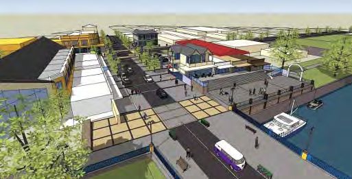
You can also read