Androscoggin Brunswick-Topsham Riverwalk Feasibility Study - DRAFT May 1, 2021
←
→
Page content transcription
If your browser does not render page correctly, please read the page content below
DRA FT
                                                  May 1, 2021

Androscoggin Brunswick-Topsham
      Riverwalk Feasibility Study

             Illustration by Anthony Muench RLA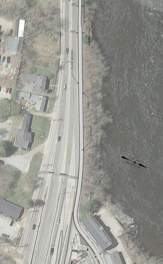
TOWN OF BRUNSWICK/ MAINEDOT | RIVERWALK TRAIL FEASIBILITY STUDY

                                                                                                                     6.3 Riverwalk Committee Meetings to present the Draft and Final
                                                                                                                     Recommendations. ................................................................................. 21
                                                                                                                     6.4 Town Council Meeting ...................................................................... 22
 Contents
 1.0 INTRODUCTION .................................................................. 2
    1.1 Study Area ........................................................................................... 2
    1.2 Advisory Committee ........................................................................... 2
    1.3 Related Studies ................................................................................... 2
    1.4 Background Information ..................................................................... 2
    1.5 Purpose and Need ............................................................................... 2

 2.0 PROJECT INITIATION AND DATA COLLECTION ............... 4
    2.1 Kick-off Meeting .................................................................................. 4
    2.2 Project Survey / Base Mapping ........................................................... 4
    2.3 Design Field Reviews / Review of Existing Conditions ........................ 4
    2.4 Environmental Field Reviews / Review of Existing Data ..................... 4

 3.0 ALTERNATIVE ALIGNMENT ANALYSIS ............................... 5
    3.1 Segment A – Swinging Bridge to Bow Street ...................................... 5
    3.2 Segment B – Bow Street/Cabot Street to Maine Street ................... 10

 4.0 ENVIRONMENTAL RESOURCES ....................................... 15
    4.1 Historic .............................................................................................. 15
    4.2 State Conservation Land ................................................................... 15
    4.3 Plant and Animal Habitat .................................................................. 16
    4.4 Wetlands ........................................................................................... 16
    4.5 Property Ownership .......................................................................... 17

 5.0 ALTERNATIVE COST ANALYSIS ....................................... 18
    5.1 Segment A – Swinging Bridge to Bow Street .................................... 18
    5.2 Segment B – Bow Street/Cabot Street to Maine Street ................... 19
    5.3 Total Cost Summary .......................................................................... 20

 6.0 PUBLIC OUTREACH .......................................................... 21
    6.1 Advisory Committee Kick-Off Meeting ............................................. 21
    6.2 Advisory Committee Working Session .............................................. 21

                                                                                                                                                                                                                             Page | 1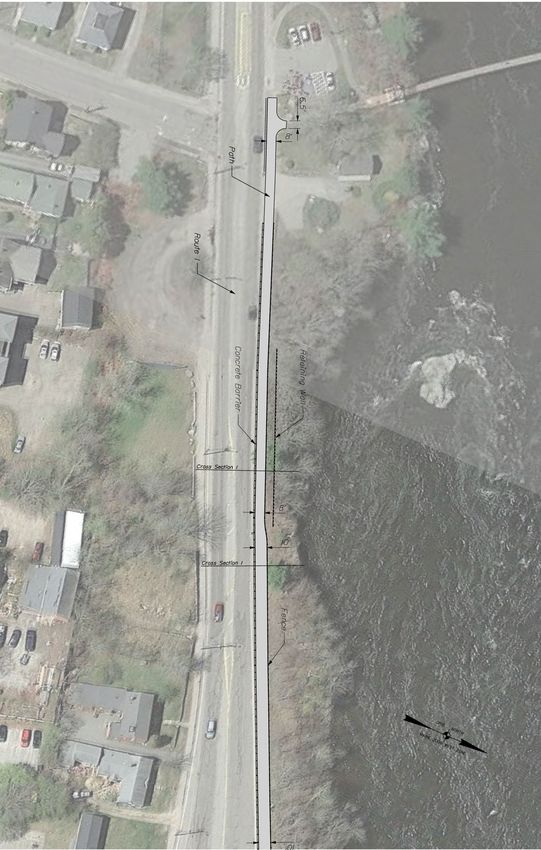
TOWN OF BRUNSWICK/ MAINEDOT | RIVERWALK TRAIL FEASIBILITY STUDY
upgrade is necessary. Improvements proposed in this grant application will allow safe fully accessible, dedicated in-town walking loop along both sides of the
1.0 INTRODUCTION passage and clear separation of cyclists and pedestrians from vehicular traffic along Androscoggin River. The plan envisions a safe route along the
intensely busy urban streets in a 1.25 mile loop running between Brunswick and Androscoggin River that encompasses and enhances the Swinging
The Town of Brunswick and the Maine Department of Transportation Topsham. It should be noted that this is from the application for the original project Bridge and the Frank J. Wood Bridge connecting Brunswick and
(MaineDOT) contracted with T. Y. Lin International (TYLI) to conduct and not all elements have been constructed. Topsham.
a feasibility study for the Androscoggin Brunswick-Topsham Riverwalk
beginning at the Swinging Bridge and ending at the Frank J. Wood Describe why this project is important to your community and
region):
Bridge via Mill, Bow, Cabot and Maine Streets. The purpose of the
study is to create and widen a bicycle and pedestrian travel-way to the March 2007, building on the success of the rehabilitation of the historic
recommended minimum 8-foot width to accommodate concurrent use John A. Roebling designed Swinging Bridge, residents of Topsham and
by bicyclists, pedestrians and people with disabilities. Guardrails Brunswick formed the Androscoggin Brunswick-Topsham Riverwalk
(separating vehicles from bicyclists and pedestrians), handrails, safety Advisory Committee. This Advisory Committee brings together the
bollards and detectable warning fields will be installed as required and Topsham and Brunswick communities to design, support, and create a
appropriate for optimum safety. 1.25-mile, 4-season, fully accessible, dedicated in-town walking loop along
both sides of the Androscoggin River. The plan envisions a safe route
1.1 Study Area along the Androscoggin River that encompasses and enhances the
Figure 1.1 shows the study area between the Swinging Bridge and the Swinging Bridge and the Frank J. Wood Bridge connecting the two
Frank J. Wood Bridge. communities.
Describe the potential positive impacts on the community,
1.2 Advisory Committee including at a minimum improving safety, mobility, or
The following Advisory Committee was formed to help guide the study. transportation in general, and the local/regional economy:
Tom Farrell, Town of Brunswick Phase 3. In Brunswick, construct a safe bike/pedestrian travel way along
Ryan Leighton, Town of Brunswick Mill Street from Bow Street intersection with Route 1 entrance ramp to
the Androscoggin Swinging Bridge. Parts of the walkway will be widened
Jay Astle, Town of Brunswick to provide overlooks. The walkway will be inside the guardrail to protect
Ryan Barnes, Town of Brunswick pedestrians and cyclists from roadway traffic. Phase 4. In Brunswick,
wide sidewalks from Maine Street along Cabot and Bow streets to the
Josh Katz, Riverwalk Committee Route 1 entrance ramp. Project will include widening and clearly defining
Nate Howard, MaineDOT Cabot Street sidewalk through Fort Andross parking areas and adding
green space as possible. Phase 5. In Topsham at 2 Main Street, create a
Patrick Adams, MaineDOT pocket park along river and stairway up to Frank J. Wood Bridge
Tom Errico, T.Y. Lin International (“Green Bridge”). The stairway will have two semi-circular river
overlooks. Access to the Green Bridge from the pocket park for wheelchairs, bicycles,
1.3 Related Studies and strollers will be maintained on
The following studies were used in development of recommendations: Summer and Main Street sidewalks around the Priority Business Center, 2 Main
Street. Trails link historic and cultural sites, providing opportunities for community
MaineDOT QCP 2014-2015 Application dated July 2012 festivals, events, and competitions. Interpretive signs along trails identify areas of
Brunswick Maine Street Feasibility Study, MaineDOT historical interest, such as buildings, river transportation, bridges, rail lines, and
native heritage. The trails also provide bike routes so that urban commuters can ride
Frank J. Wood Bridge Replacement Project their bikes to work or walk, which reduces smog emissions.
1.4 Background Information
The MaineDOT QCP Application noted the following: 1.5 Purpose and Need
Describe the project(s) transportation value(s) and purpose(s): The purpose of the study is to create and widen a bicycle and pedestrian
travel-way to the recommended minimum 8-foot width to
Cyclists and pedestrians are challenged to travel to and from the Swinging Bridge and accommodate concurrent use by bicyclists, pedestrians and people with
the Frank J. Wood Bridge via Mill, Bow, Cabot and Maine streets. A safety disabilities. The need is associated with creating a 1.25-mile, 4-season,
Page | 2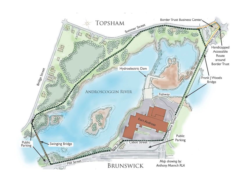
TOWN OF BRUNSWICK/ MAINEDOT | RIVERWALK TRAIL FEASIBILITY STUDY

                                           Figure 1.1: Study Area

                                                                    Priority Business Center

                                                                                               Page | 3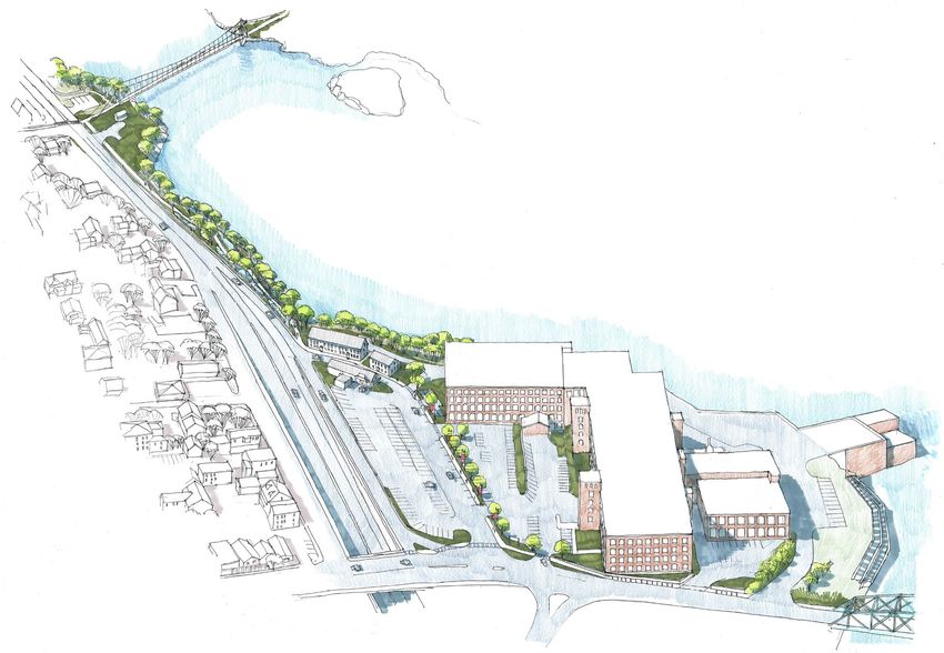
TOWN OF BRUNSWICK/ MAINEDOT | RIVERWALK TRAIL FEASIBILITY STUDY
The Riverwalk Committee would prefer to carry the path along
2.0 PROJECT INITIATION AND DATA
the river. It is not likely due to an approximately one-story grade
COLLECTION separation behind the mill. The Committee will need to
document why we aren’t proceeding with this alternative.
Transitioning from bicycle lanes and sidewalks to a multi-use
2.1 Kick-off Meeting path is a major design requirement. It is likely easiest to
A Kick-Off meeting was held on December 11, 2018 and key discussion transition at the signal at the Pool Table intersection area.
items included:
The Pool Table bridge project is looking at a roundabout, a new
The section of roadway was recently repaved and designed by ramp, combining streets, changing traffic flow, and adding a
Wright-Pierce. They have cross-section data that can be Single Point Interchange (SPUI). These alternatives will change
supplemented with LIDAR data. traffic flow in the study area which needs to be considered
The Committee was unsure of the available right-of-way during any Route 1 road diet analysis.
information available. MaineDOT will check what information The Town will need to write to MaineDOT after the study to
they have. Wright-Pierce may also have some available acquire funds.
information. TYLI will inquire with them.
MaineDOT is looking at about $400,000-$500,000 for the
The sewer pump station may have some equipment in the area. project.
The utilities can be found using Brunswick’s online GIS
database. Any design needs to consider impacts on utilities.
2.2 Project Survey / Base Mapping
The mill-and-fill project puts a moratorium on touching the The base map for the project was based on a review of available
pavement. We can get a waiver to do shoulder work. information provided by the Town and available LIDAR survey from
TYLI will look at what environmental information is available in the Frank J. Wood Bridge and Maine Street/Route 1 MaineDOT
the area from the Frank J. Wood Bridge project. projects.
Due to the proximity to the mill, Cabot Street may have historic
protections as well as the apartment buildings on the west side 2.3 Design Field Reviews / Review of Existing
of Bow Street. Conditions
TYLI will get information on the drilling samples from the TYLI conducted a field review of conditions particularly as it relates to
Frank J. Wood project. roadway measurements as documented later in this report.
The “Pool Table” bridge feasibility project has the potential to 2.4 Environmental Field Reviews / Review of
aid or hinder this project and needs to be considered in any
designs. Existing Data
TYLI obtained information about the environmental resources in the
The Town and the State will create minimum design project area to identify potential impacts to natural resources. This will
requirements. assist with impact avoidance and minimization discussions and
10’ is the preferred width for a shared use path but special decisions during the future design process; assist in identifying the
constraints are understood for this project. The curb separation environmental permit requirements for federal, state, and local
standard needs to be clarified by MaineDOT. Standard best authorities; and facilitate project planning and permitting discussions.
practice is to separate the path from the road.
The Riverwalk Committee would prefer a barrier for the path.
MaineDOT will determine if the barrier needs to be crash
worthy. Federal guidelines say it doesn’t.
There is a possibility that Cabot Street and the Route 1 On-
Ramp will get combined into one road.
Page | 4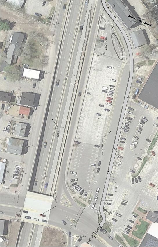
TOWN OF BRUNSWICK/ MAINEDOT | RIVERWALK TRAIL FEASIBILITY STUDY
However, this left-turn lane is used by MaineDOT plows trucks and
3.0 Alternative Alignment Analysis other large vehicles, so a wider 11-foot lane is suggested. Assuming 11-
foot travel lanes and 4-foot shoulders, Route 1 could consist of a curb-
For the purposes of this feasibility study, the general path alignment to-curb width of 41 feet compared to the existing 43 feet 7 inches.
evaluated is along Mill Street, Bow Street, Cabot Street, and Maine Accordingly, the northerly curb line could be adjusted to gain 2.5 feet
Street between the Swinging Bridge and ending at the Frank J. Wood for the path. The existing sidewalk is 5’6” wide, so the curb adjustment
Bridge. It is assumed that this effort will investigate a location of the may provide sufficient space for an 8-foot path without any widening
Riverwalk parallel to Mill Street to the west and investigate various toward the river. To obtain the 10-foot preferred width, plus an
options along Bow Street and Cabot Street depending on information additional foot for a barrier (separating path users from Route 1 traffic),
from the MaineDOT Maine Street Bridge Feasibility Study and design it would require adjusting the location of the guardrail location about 3
plans for the Frank J. Wood Bridge project. feet towards the river.
At the Kick-Off meeting it was noted that ideally the Riverwalk
Committee would prefer to have an alignment that would follow the
river. Given significant constraints between the river and the mill
building and parking areas and the grade difference at the hydroelectric
dam wall, this alignment was eliminated from consideration.
3.1 Segment A – Swinging Bridge to Bow Street
Alternative 1
This alternative investigated reduction of lane and shoulder widths on
Route 1 to eliminate or minimize the need for retaining walls along the
path in accordance with MaineDOT’s HCP philosophy and flexible
design guidelines. Specifically, TYLI reviewed traffic volumes and safety
information and identified a possible roadway cross-section given the
Route 1 HCP 1 classification. This Alternative in essence investigated
travel lane width and shoulder width reductions that would minimize or
eliminate retaining structures along the slope to the Androscoggin
River. Detailed field measurements were obtained to evaluate the
feasibility of this alternative.
Narrowing Route 1 Roadway Pavement Cross-Section
The existing dimension of the Route 1 cross-section just north of
Cushing Street is (see Figure 3.1):
5’6” Sidewalk
3’6” Shoulder
12’4” Travel lane
11’3” Left turn lane
13’2” Travel lane
3’4” shoulder
MaineDOT requires a typical roadway section based on the Priority
Classification for Route 1 which is providing 4-foot shoulders and 11-
foot travel lanes. It may be possible to have a 10-foot left-turn lane.
Page | 5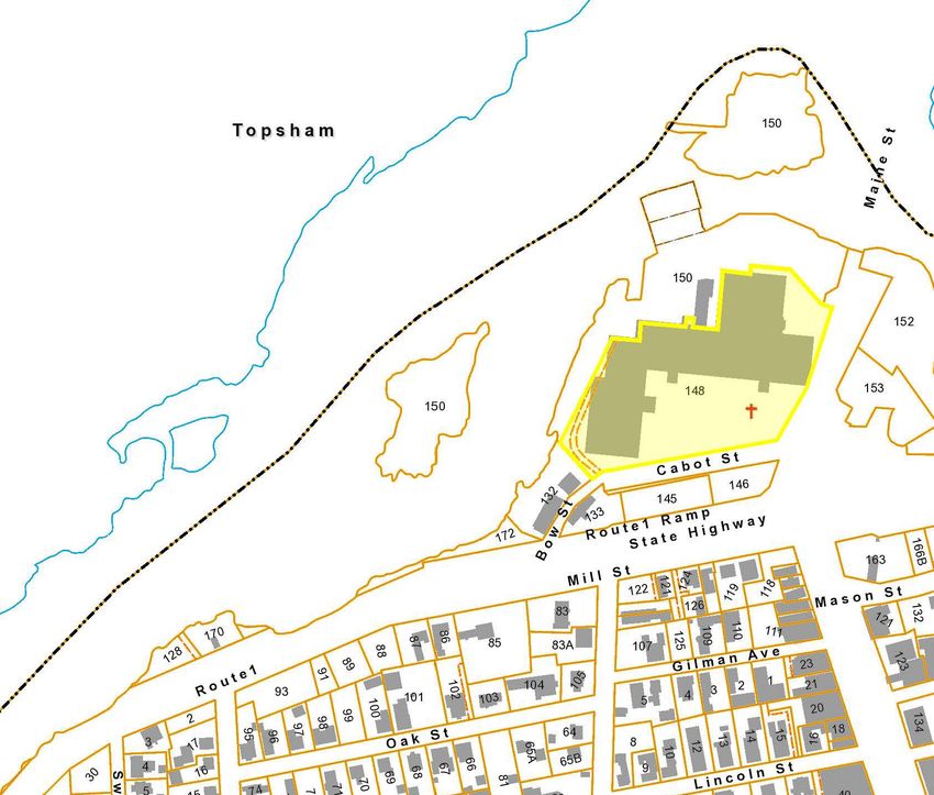
TOWN OF BRUNSWICK/ MAINEDOT | RIVERWALK TRAIL FEASIBILITY STUDY

     Figure 3.1: Existing Roadway Dimensions

                                                                  Page | 6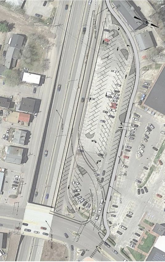
TOWN OF BRUNSWICK/ MAINEDOT | RIVERWALK TRAIL FEASIBILITY STUDY

 Eliminating the Route 1 Left-Turn Lane
 The key concern with eliminating the left-turn lane on southbound
 Route 1 is the impact a shared through/left lane would have on mobility
 and safety. Intersection turning movement volumes are not available.
 However, MaineDOT conducted Automatic Traffic Recorder counts
 on Cushing Street and Route 1 in August 2019. Those counts are
 presented to the right and indicates Route 1 has a daily volume of
 approximately 29,000 vehicles and Cushing Street has a daily volume of
 1,800 vehicles. The heaviest two-way peak hour volume on Cushing
 Street is 164 vehicles between 3:00 and 4:00 PM. The corresponding
 two-way volume on Route 1 is 1,982 vehicles. The magnitude of traffic
 on Route 1 would warrant the need for a left-turn lane for a very low
 level of left turning traffic. Assuming a 50/50 distribution (half of the
 164 vehicles) and the 60% is originating from the north, the peak hour
 left-turn volume is estimated to be approximately 50 vehicles. This level
 of traffic would easily warrant a lane and therefore elimination of the
 left-turn lane is not recommended.

 Conclusion: Given limited available excess pavement on Route 1, the cost
 to adjust the curb location and the desire to maintain a left-turn lane for
 movements onto Cushing Street, Alternative 1 is not recommended.

                                                                               Page | 7
TOWN OF BRUNSWICK/ MAINEDOT | RIVERWALK TRAIL FEASIBILITY STUDY
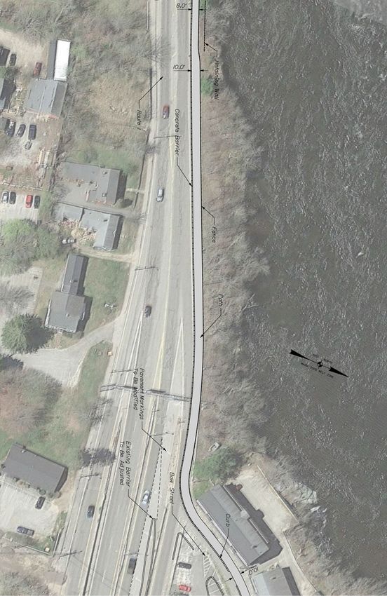
Alternative 2
This Alternative assumes no changes to the Route Figure 3.2: Recommended Path Alignment
1 (Mill Street) roadway pavement configuration and
thus assumes the path will be located north of the
existing Route 1 curb line (the sidewalk will be
widened). Just north of the Swinging Bridge the
Androscoggin River gets very close to the road (see
cross-sections). It will be difficult to construct a
10-foot path and barrier along Route 1 without the
need for a retaining structure. Accordingly, a
retaining structure that is approximately 45 feet in
length will be required.
Figure 3.2 illustrates the path plan view location
and details. Figure 3.3 depicts cross-section details
along Route 1.
Page | 8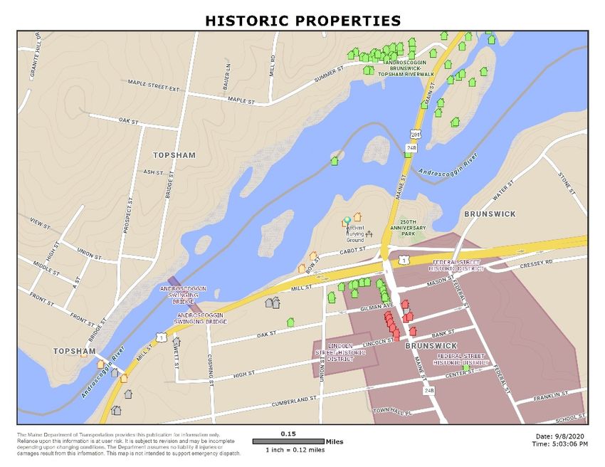
TOWN OF BRUNSWICK/ MAINEDOT | RIVERWALK TRAIL FEASIBILITY STUDY

                                                                  Figure 3.3: Cross-Sections (see Figure 3.2 for location)

                                                                                                                             Page | 9
TOWN OF BRUNSWICK/ MAINEDOT | RIVERWALK TRAIL FEASIBILITY STUDY
3.2 Segment B – Bow Street/Cabot Street to Final details on access to Bow Street properties and the side of
Fort Andross were not determined during the Maine Street
Maine Street Feasibility Study. Driveway crossings of the path are likely, and
Two alternatives were evaluated from a cost perspective. Alternative 1 that design should also favor the safety of path users versus
assumes the recommendation from the Maine Street Bridge Feasibility vehicles.
Study is constructed and thus the cost is only for adding the path.
Alternative 2 assumes the Maine Street Bridge Feasibility Study
recommendation is not implemented and the path is constructed under
existing conditions on Bow and Cabot Streets. Figure 3.4: Alternative 1 Path Alignment
Alternative 1: With the Brunswick Maine Street Bridge Feasibility
Study Recommended Concept
The Brunswick Maine Street Bridge was initially funded as a deck
replacement in MaineDOT’s 3-Year Work Plan. In 2018, the feasibility
study was initiated by the Bureau of Planning at the request of the
Bridge Program to evaluate mobility issues and to consider
transportation improvement alternatives on or adjacent to the Maine
Street Bridge over Route 1 in downtown Brunswick. Alternative A6 -
Simplified Maine Street/Cabot Street Intersection with a New Signal at
Mason Street was recommended and assumed the Route 1 Southbound
On-Ramp is combined with Cabot Street to create one eastbound
approach. A traffic signal was also added at Mason Street to allow the
southbound left-turn movement to pass more easily. Figures 3.4 and
3.5 depict the A6 Alternative and that concept plan and includes the
provision of a 10-foot path located within the reconfigured Fort
Andross Mill parking lot. Some details are noted as follows.
The area at the corner of Bow Street and the Route 1
Southbound On-Ramp is constrained. The A6 plan includes
changes to this merge area such that space is created for
construction of the path around the corner.
The path terminates at Maine Street, where a signalized crossing
is proposed. The crosswalk and signal timing shall account for
bicycles.
The layout of the parking spaces will need to consider vehicle
overhang impacts to trail users. Appropriate separation is
suggested.
It is suggested that the parking lot driveway crossings of the
path be designed for optimal safety of path users. A raised path
is suggested.
Page | 10TOWN OF BRUNSWICK/ MAINEDOT | RIVERWALK TRAIL FEASIBILITY STUDY
Figure 3.5: Alternative 1 Path Alignment
Page | 11TOWN OF BRUNSWICK/ MAINEDOT | RIVERWALK TRAIL FEASIBILITY STUDY
Alternative 2: Without the Brunswick Maine Street Bridge
Figure 3.6: Alternative 2 Path Alignment
Feasibility Study Recommended Concept
Alternative 2 assumes the path is constructed in the location of the
existing sidewalk along Bow and Cabot Streets. See Figures 3.6, 3.7
and 3.8 depict Alternative 2 conditions. The following should be noted
with this Alternative:
• The path is assumed to be 10 feet wide.
• Improvements are required at the corner of Bow Street and the
Route 1 southbound On-Ramp. This will require modification
to the Waterfront Maine Brunswick LLC parking area.
• On-Street parking is eliminated.
• Existing utility poles may impact the effective width of the path
and relocation may be required.
Figure 3.7: Alternative 2 Cabot St. Cross-Section
Page | 12TOWN OF BRUNSWICK/ MAINEDOT | RIVERWALK TRAIL FEASIBILITY STUDY
Figure 3.8: Alternative 2 Path Alignment
Page | 13TOWN OF BRUNSWICK/ MAINEDOT | RIVERWALK TRAIL FEASIBILITY STUDY
Frank J. Wood Bridge Project
Figure 3.9 illustrates the preliminary design plan for the
project, the limit of work ends prior to the Cabot Street Figure 3.9: Frank J. Wood Bridge Plan
intersection. The project will be providing two 5-foot
shoulders and 6-foot sidewalks on both sides of the bridge.
Bicyclists traveling from the proposed Riverwalk will cross at
the signalized Cabot Street intersection to access the
shoulder/bike lane.
Proposed Riverwalk
location approaching
Maine Street
Page | 14TOWN OF BRUNSWICK/ MAINEDOT | RIVERWALK TRAIL FEASIBILITY STUDY
4.0 ENVIRONMENTAL RESOURCES 4.2 State Conservation Land
As noted in Figure 4.2, there are no state conservation lands located
within the study area. The nearest conservation land is the 250th
The following documents environmental resources obtained from Anniversary Park located across Maine Street at Cabot Street.
Town and State online resources. These include a review of historic,
state conserved land, and plant and animal habitat.
4.1 Historic
According to state data, there are three properties in the vicinity of the
project that are eligible for historic designation (see Figure 4.1 and Figure 4.2: Conservation Land
appendix). These properties include:
2 Bow Street – Cabot Mill Tenement
18 Bow Street
Fort Andross
Figure 4.1: Historic Resources
Page | 15TOWN OF BRUNSWICK/ MAINEDOT | RIVERWALK TRAIL FEASIBILITY STUDY
4.3 Plant and Animal Habitat
No know endangered plant or animal habitat were identified in the
project area. See Figure 4.3
Figure 4.3: Plant and Animal Habitat
4.4 Wetlands
No know wetlands were identified in the project area.
Page | 16TOWN OF BRUNSWICK/ MAINEDOT | RIVERWALK TRAIL FEASIBILITY STUDY
4.5 Property Ownership
Figure 4.4 depicts property lots according to Town of Brunswick Figure 4.4: Property Ownership
information. From the Swinging Bridge to Bow Street properties along
the path alignment are owned by State and Municipal entities. A
summary of each lot ownership is provided as follows:
Lot 128 – MaineDOT
Lot 170 – Brunswick Sewer District
Lot 172 – MaineDOT
Lot 132 – Taggart Realty, LLC
Lot 148 – Waterfront Maine Brunswick, LLC
Lot 133 – Waterfront Maine Brunswick, LLC
Lot 145 – Town of Brunswick
Lot 146 – MaineDOT
Page | 17TOWN OF BRUNSWICK/ MAINEDOT | RIVERWALK TRAIL FEASIBILITY STUDY
5.0 ALTERNATIVE COST ANALYSIS
TYLI developed planning-level cost estimates for recommendations
(including highway and trail and potential right-of-way costs) according
to concept level plans. Cost estimates were prepared for the path Segment A - Swinging Bridge to Bow Street
segments identified previously.
Description Item # Quantity Say Unit Price Cost
5.1 Segment A – Swinging Bridge to Bow Street
The Town requested that a cost be estimated for widening the path to Common Excavation 203.20 295.24 300 $ 30.00 $9,000.00
10-feet in the constrained section, where it is assumed to be 8-feet wide. Gravel 304.10 306.30 325 $ 45.00 $14,625.00
The 2-foot widening would add $35,000.00 to the project cost (which is
not included in the table to the right). Given that the cost to widen the Pavement 403 101.06 110 $ 214.54 $23,599.40
path to 10-feet is only $35,000.00, it is recommended that the project
Perm. Conc. Barrier 526.321 65.00 65 $ 299.35 $19,457.75
include this and the total cost for Segment A is $1,032,237.13.
G.R. Double Faced 606.1302 793.00 793 $45.75 $36,279.75
Chain link Fence 607.16 825 825 $34.10 $28,132.50
Mech. Stab. E. R. Wall 677.2 4550 4550 $ 73.71 $335,380.50
Curb Type 3 609.31 793 793 $ 15.00 $11,895.00
Drum 652.33 45 45 $ 65.00 $2,925.00
Cone 652.34 100 100 $ 20.00 $2,000.00
Construction Signs 652.35 400 400 $ 15.00 $6,000.00
MOTCD 652.36 80 80 $ 250.00 $20,000.00
Flagger 652.38 1800 1800 $ 27.00 $48,600.00
Sub Total $557,894.90
30% Contingency $167,368.47
Mobilization 659.10 $72,526.34
Construction Total $797,789.71
Preliminary Engineering 15% $119,668.46
Right-of-Way $0
Construction Engineering 10% $79,778.97
Project Total $997,237.13
Page | 18TOWN OF BRUNSWICK/ MAINEDOT | RIVERWALK TRAIL FEASIBILITY STUDY
5.2 Segment B – Bow Street/Cabot Street to
Maine Street
Alternative 1 – Riverwalk Abuts Maine Street Bridge Feasibility
Project
Alternative 1 – Riverwalk Abuts Maine Street Bridge Feasibility Project
Description Item # Quantity Unit Price Cost
Common Excavation 203.20 362.963 $ 30.00 $10,888.89
Gravel 304.10 259.2593 $ 45.00 $11,666.67
Pavement 403 85.56 $ 250.00 $21,388.89
Curb Type 5 609.34/35 24 $ 65.00 $1,560.00
Pavement Marking 627.744 160 $ 3.75 $600.00
Drum 652.33 15 $ 65.00 $975.00
Cone 652.34 35 $ 20.00 $700.00
MOTCD 652.36 30 $ 250.00 $7,500.00
Flagger 652.38 250 $ 27.00 $6,750.00
Sub Total $62,029.44
30% Contingency $18,608.83
Mobilization 659.10 $8,063.83
Construction Total $88,702.11
Preliminary Engineering 15% $13,305.32
Right-of-Way $30,000.00
Construction Engineering 10% $8,870.21
Project Total $140,877.64
Page | 19TOWN OF BRUNSWICK/ MAINEDOT | RIVERWALK TRAIL FEASIBILITY STUDY
Alternative 2 – Separate Path Project
Alternative 2 – Separate Path Project
Description Item # Quantity Say Unit Price Cost
Common Excavation 203.20 723.70 750 $30.00 $ 22,500.00
Gravel 304.10 499.26 550 $45.00 $24,750.00
Pavement 403 194.44 200 $200.00 $40,000.00
Vertical Curb Type 1 609.11 640 640 $40.00 $25,600.00
Term. Curb Type 1-8' 609.238 12 12 $350.00 $4,200.00
Curb Type 5 609.34/35 23.55 24 $65.00 $1,560.00
Reset Curb Type 1 609.38 50 50 $35.00 $1,750.00
Pavement Marking 627.744 156 160 $3.75 $600.00
Drum 652.33 45 45 $65.00 $2,925.00
Cone 652.34 100 100 $20.00 $2,000.00
Construction Signs 652.35 250 250 $15.00 $3,750.00
MOTCD 652.36 65 65 $250.00 $16,250.00
Flagger 652.38 700 700 $27.00 $18,900.00
Sub Total $164,785.00
30% Contingency $49,435.50
Mobilization 659.10 $21,422.05
Construction Total $235,642.55
Preliminary Engineering 15% $35,346.38
Right-of-Way $30,000.00
Construction Engineering 10% $23,564.26
Project Total $324,553.19
* This estimate assumes the Maine Street Bridge project is not completed.
5.3 Total Cost Summary
Alternative in conjunction with Maine Street Bridge
Project – $1,174,000.00
Alternative without Maine Street Bridge Project –
$1,357,000.00
Page | 20TOWN OF BRUNSWICK/ MAINEDOT | RIVERWALK TRAIL FEASIBILITY STUDY
separation behind the mill. The Committee will need to Pre-meeting workshop 7:01 – 7:29 p.m.:
6.0 PUBLIC OUTREACH document why we aren’t proceeding with this alternative.
TY-Lin engineer, Tom Errico, walked us through his Power Point
Transitioning from bicycle lanes and sidewalks to a multi-use presentation of the preliminary Riverwalk plan. He will forward
6.1 Advisory Committee Kick-Off Meeting path is a major design requirement. It is likely easiest to
A Kick-Off meeting was held on December 11, 2018 and key discussion Nancy E. Randolph a pdf of the presentation. Some key points of
transition at the signal at the Pool Table intersection area.
items included: discussion were:
The Pool Table bridge project is looking at a roundabout, a new
The section of roadway was recently repaved and designed by 1. The estimated cost of the plan is $1,280,000 (rough estimate and no
ramp, combining streets, changing traffic flow, and adding a
Wright-Pierce. They have cross-section data that can be lighting is included).
Single Point Interchange (SPUI). These alternatives will change 2. The current curb-line along Mill Street will need to be maintained.
supplemented with LIDAR data. traffic flow in the study area which needs to be considered The plan calls for a reduction of the path width from 10’ to 8’ for an
The Committee was unsure of the available right-of-way during any Route 1 road diet analysis. estimated 100’ (Tom Errico will confirm the exact distance) along
information available. MaineDOT will check what information The Town will need to write to MaineDOT after the study to Mill Street. This is due to the limited real estate between Route 1
they have. Wright-Pierce may also have some available acquire funds. and the Androscoggin River and the cost of a retaining wall. Nancy
information. TYLI will inquire with them. E. Randolph stressed the need to maintain the 10’ width for the
MaineDOT is looking at about $400,000-$500,000 for the entire length of the path. Tom Errico agreed to provide a cost
The sewer pump station may have some equipment in the area. project
The utilities can be found using Brunswick’s online GIS estimate to do that. Patrick Adams noted that the 8’ width meets
national standards.
database. Any design needs to consider impacts on utilities. 6.2 Advisory Committee Working Session 3. The plan calls for the path to follow the current location of the
The mill-and-fill project puts a moratorium on touching the A status meeting was held on November 22, 2019 to discuss progress. sidewalk along Cabot Street.
pavement. We can get a waiver to do shoulder work. Discussion items included: 4. The plan does not include any details or cost for the connection to
the new/rebuilt FJW Bridge.
TYLI will look at what environmental information is available in In the area from the Swinging Bridge to Bow Street changes to
5. None of the path cost is included in the Main Street Bridge
the area from the Frank J. Wood Bridge project. the Route 1 cross-section are not feasible. Accordingly, a section
project (Pool Table). In fact, much of the current Riverwalk plan
of the path will require a retaining structure. This was
Due to the proximity to the mill, Cabot Street may have historic might need to be modified if the Pool Table project is changed from
specifically discussed in terms of field measurements and traffic
protections as well as the apartment buildings on the west side the currently preferred option.
conditions.
of Bow Street. 6. The estimated timeline is for a draft by July, Town
Reviewed the draft recommendations for the Maine Street Council/Riverwalk Committee approval in August & September
TYLI will get information on the drilling samples from the Bridge Street Feasibility Study. Specifically, the path alignment leading to final plans by October.
Frank J. Wood project. was presented.
The “Pool Table” bridge feasibility project has the potential to It was noted that the path will terminate at Maine Street and Our Committee thanked all the guests who
aid or hinder this project and needs to be considered in any bicyclists headed to Topsham would need to cross at the participated in the meeting. Regular Meeting
designs. signalized intersection.
The Town and the State will create minimum design Josh Katz called the meeting to order at 7:29 p.m.
requirements.
Minutes: The April 22, 2020 minutes were unanimously accepted as
10’ is the preferred width for a shared use path but special 6.3 Riverwalk Committee Meetings to present presented. (Nancy E. Randolph motioned and Melissa Fochesato
2nd).
constraints are understood for this project. The curb separation the Draft and Final Recommendations.
standard needs to be clarified by MaineDOT. Standard best Old Business:
practice is to separate the path from the road. May 27, 2020 Zoom Meeting (Notes provide by the Riverwalk I. Discussion of the Feasibility Study Draft Report:
The Riverwalk Committee would prefer a barrier for the path. Committee) 1. Increasing the width to 10’ for the entire length is our only open
MaineDOT will determine if the barrier needs to be crash Present: Co-Chairs: Nancy E. Randolph & Josh Katz, Secretary: Don question at the moment.
worthy. Federal guidelines say it doesn’t. 2. Tom Farrell informed us that MDOT might be limiting any
Gower Members: Tom Farrell, Bill Brillant, Mellissa Fochesato, Rick
Bike/Ped projects $400,000 to $500,000 next year. This
There is a possibility that Cabot and the Route 1 On-Ramp will Wilcox & Pam LeDuc Guests: Ryan Barnes, Tom Errico, Patrick would seriously increase our fundraising need. Tom Farrell
get combined into one road. Adams, Nate Howard and Martin Rooney Absent: Members: Alison will follow-up on this concern. Nancy E. Randolph suggested
The Riverwalk Committee would prefer to carry the path along Harris & Dot Riendeau Advisory Member: Tony Muench we contact Senator Angus King for some federal support of
the river. It is not likely due to an approximately one-story grade the project.
Page | 21TOWN OF BRUNSWICK/ MAINEDOT | RIVERWALK TRAIL FEASIBILITY STUDY
3. MDOT has taken over the design work from Ty-Lin for the
Maine Street Bridge (Pool Table) project. This, and expected
2021 budgeting issues, could affect the final plan and how it
relates to our project.
4. Tom Errico suggested we have a fall back plan to
complete the walkway in sections. He recommended
focusing on the Swinging Bridge to Cabot Street
section.
5. No EPA study cost has been included with the project.
6. Tom Farrell brought up a question about the need for
public input. Other than lighting there is limited opportunity
for input. We will review this as needed along the path to
approval.
7. The RTP Grant proposal is still on the table. However, we might
not have the final plan ready by the September 25, 2020 deadline.
Second Meeting Pending
6.4 Town Council Meeting
Pending
Page | 22You can also read