ALGARVE TOURISM PRODUCTS ASSESSMENT AND DEVELOPMENT ACTION PLAN - Walking & Cycling Situation Analysis - Appendices
←
→
Page content transcription
If your browser does not render page correctly, please read the page content below
29th
                                                   Oct
                                                  2015

    ALGARVE TOURISM PRODUCTS
    ASSESSMENT AND DEVELOPMENT
    ACTION PLAN

    Prepared on behalf of

    Walking & Cycling Situation Analysis -
    Appendices

                                        www.tourismdev.com

1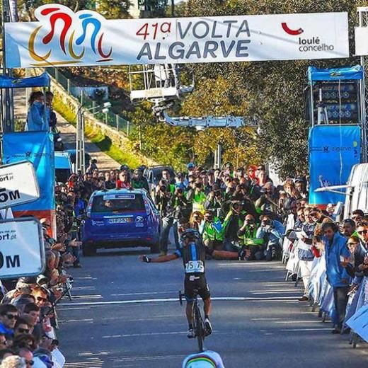
Algarve Tourism Products Assessment and Development Action Plan – Walking & Cycling Situation Analysis

Contents
    Appendices

    Appendix 1: Product Audit Detail                                                                   1

    Appendix 2: Consultation Programme Summary                                                        34

    Appendix 3: Eurovelo Routes and European Long Distance Walking Routes                             35

    Appendix 4: Maps                                                                                  44

    Appendix 5: Algarve Local Trade Survey                                                            47

i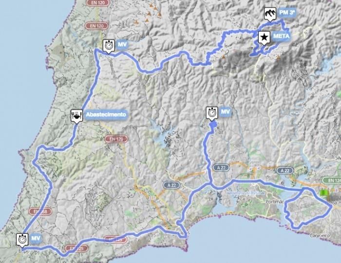
Algarve Tourism Products Assessment and Development Action Plan – Walking & Cycling Situation Analysis

    Appendix 1: Product Audit Detail

    A1.1 Area Profile

    The Algarve region covers 4,997sq.km, shown on Map 1: Study Area Context in
    Appendix A4. The Algarve consists of a wide variety of topographies and
    geographical features. The coastal (Litoral) area to the east of Faro is characterised
    by the wetland areas of the Ria Formosa Natural Park with a succession of towns
    including Olhao, Tavira, and V.R do Santo Antonio. The coast to the west of Faro is
    increasingly rugged with cliffs interspersed by the beaches the Algarve is famous for.
    The west coast, Costa Vicentina, consists of breath-taking cliffs and beaches all part
    of the Cape St Vincent Natural Park and then the Sudoeste Alentejano e Costa
    Vicentina Natural Park. The southern coast is approximately 155km long and the
    western coast around 50km from Cape St Vincent to the border with the neighbouring
    region, Alentjo, to the north.

    Moving away from the coast to the Barochal area the topography begins to consist
    of more upland areas interspersed with farmland (olives and almonds and other fruits);
    beyond are the mountain ranges of the Algarve with many national forests in the
    valleys between the upland areas. There are exceptional views from the peaks of
    Rocha da Pena and from the Monchique area over the entire Algarve inland area
    and beyond to the coast with the highest point of the Algarve at Foia (902m).

    The eastern border of the Algarve follows the River Guadiana corridor and consists of
    wetland areas to the south close to Castro Marim, becoming increasingly
    mountainous when moving north. The Guadiana corridor includes several settlements
    with the town of Alcoutim in the north-west.

    The inter-municipal community of the Algarve region includes sixteen municipal
    councils with a combined resident population of around 450,000. The capital of the
    Algarve region is the city of Faro, the administrative authority of the Algarve until 2004.
    The municipal councils and their principal settlements are shown in Figure A-1 below.

    Around 40% of the Algarve is designated as protected areas, indicative of the
    significant flora and fauna to be found in the region. This is a relatively high figure,
    similar to that of New Zealand. Principal protected areas in the Algarve are shown in
    Figure A-2 below.

1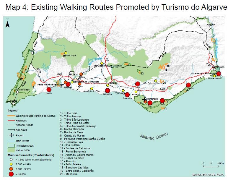
Algarve Tourism Products Assessment and Development Action Plan – Walking & Cycling Situation Analysis

    Figure A-1: Municipal Councils and Principal Settlements
     Municipal Council            Population                  Area           Principal
                                                                             Cities*/Settlements/Resorts
     Loulé                           70,622                  763.67          Loulé*
     Faro                            64,560                  202.57          Faro*
     Portimão                        55,614                  182.06          Portimão*
                                                                             Praia da Rocha
                                                                             Alvor
     Olhão                           45,396                  130.86          Olhão*
     Albuferia                       40,828                  140.66          Albuferia*
                                                                             Quarteria*/Vilamoura
     Silves                          37,126                  680.06          Silves*
                                                                             Armação de Pêra
     Tavira                          26,167                  606.97          Tavira*
     Lagos                           31,049                  212.99          Lagos*
     Lagoa                           22,975                   88.25          Lagoa*
     Vila Real de Santo              19,156                   61.25          Vila    Real   de    Santo
     António                                                                 António*
                                                                             Monto Gordo
     São Brás de                     10,662                  153.37          São Brás de Alportel
     Alportel
     Castro Marim                    6,747                   300.84          Castro Marim
     Monchique                       6,045                   395.30          Monchique
     Aljezur                         5,884                   323.50          Aljezur
     Villa do Bispo                  5,228                   179.06          Villa do Bispo
                                                                             Sagres
     Alcoutim                        2,917                   575.36          Alcoutim
     Total                          451,006                  4996.8

    Designated Areas

    Around 40% of the Algarve is designated as protected areas, indicative of the
    significant flora and fauna to be found in the region. This is a relatively high figure,
    similar to that of New Zealand.

2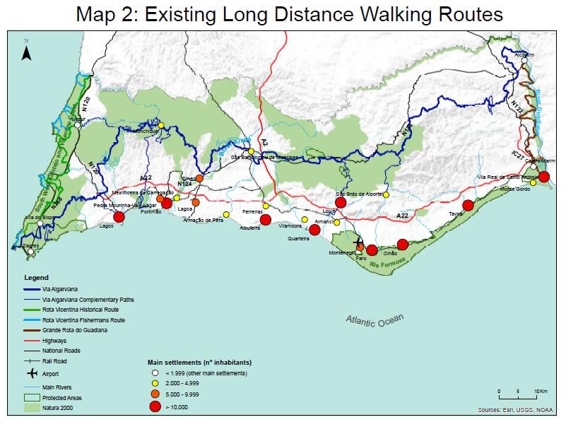
Algarve Tourism Products Assessment and Development Action Plan – Walking & Cycling Situation Analysis

    Figure A-2: Principal Protected Areas in the Algarve
    Area                            Closest                      Features
                                    City/Town/Village
    Parque Natural do Sudoeste      Runs 110km from Sagres       Coastal cliffs, & remote beaches,
    Alentejano e Costa              to north of Aljezur          unique plants, otters, foxes, 200
    Vicentina (Southwest Alentjo                                 bird types, Rota Vicentina routes
    and Costa Vicentina Natural
    Park)
    Reserve Natural do Sapal de     Castro Marim                 20 sq.km of marshland and salt
    Castro Marim e Villa Real de                                 pans,      flamingos,     spoonbills,
    Santo Antonio                                                avocet, Caspian terns, white
                                                                 storks. Portugal’s oldest nature
                                                                 reserve (1975), winter visitors
                                                                 include       greater     flamingos,
                                                                 spoonbills,      Caspian         terns,
                                                                 springtime white storks
    Parque Natural de Ria           VR do Santo Antonio-         60km long, 18,000ha - marshes,
    Formosa/Ria Formosa             Faro                         salt pans, lakes, creeks and dune
    Natural Park                                                 islands, beaches & birdlife.
                                                                 Mediterranean chameleons.
    Serra do Calderirao             Loule                        30km north of Loule, beautiful
                                                                 protected area of undulating hills,
                                                                 cork trees and harsh scubland.
                                                                 The area is renowned for its bird
                                                                 varieties.      Ancient       village,
                                                                 excellent      cuisine.   Traditional
                                                                 water taps and fountains (fonts).
    Sagres Biogenetic Reserve       Sagres                       In spring flowers are everywhere
                                                                 including     wild    orchids     and
                                                                 endemic plants.

    Rocha da Pena                   Pena                         479m high limestone outcrop in
                                                                 the Serra de Caldeirao foothills.
                                                                 Classified site beacuase of its rich
                                                                 flora and fauna. Orchids, narcissi
                                                                 and native cistus cover the slopes.
                                                                 Red foxes, Egyptian mongooses
                                                                 are common. Bird species include
                                                                 the huge eagle owl, Bonelli's
                                                                 eagle and the buzzard. Centro
                                                                 Ambimental       -  environmental
                                                                 centre in Pena village.

3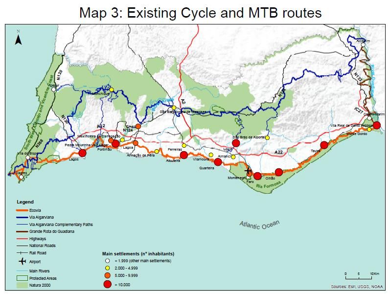
Algarve Tourism Products Assessment and Development Action Plan – Walking & Cycling Situation Analysis
A1.2 Gateways and Access Points
There are three tiers of gateways to the study area:
Tier 1: Large urban areas/primary Destinations which act as a base for many
visitors and which include significant resident populations. Faro could be
considered the primary access point for the Algarve due to the proximity of
Faro Airport.
Tier 2: Primary Destination Areas which may be part of visitor’s circuit or act as
a magnet to bring visitors into the broader area thus benefitting the
communities in the study area.
Tier 3: Secondary Destination Areas or resorts – these are included because of
their role as transport hubs, population size, strategic location and availability
of accommodation and local ancillary services. This category includes rural
villages and smaller settlements which could also be considered access points
for the four mountain areas.
Figure A-3: Gateways to the Study Area
Tier 1: Large Urban Primary Destination Areas Tier 2: Secondary
Areas/Primary Destination Areas
Destinations
Faro Monto Gordo Loule
São Brás de Alportel
Lagos Praia da Rocha Olhão
Castro Marim
Portimao Armação de Pêra Vila Real de Santo
António
Villa do Bispo
Albufeira Alvor Sagres
Alcoutim
Lagoa* Vilamoura Tavira
Aljezur
Silves
Monchique
In addition to gateways there are a range of key access points to the study area for
visitors and locals the majority of which are located in the primary destination
gateways, such as:
Rail and bus stations
Intersections with existing trails (see Appendix A4 - Map 2: Algarve Walking
Routes and Hubs)
4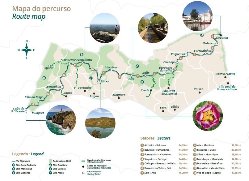
Algarve Tourism Products Assessment and Development Action Plan – Walking & Cycling Situation Analysis
Attractions in the study area: e.g. accommodation, activities, restaurants,
shops that attract people to the area.
These gateways, access points and the roads between them are the places where
economic benefits from visitors are most likely to be realised.
A1.3 Cycling Routes
The Algarve has some of the best winter cycling opportunities anywhere in Europe
with a combination of dramatic scenery with wild hill country and some untouched
beaches with very good quality roads with little traffic, once you leave the coastal
area. This combined with attractive villages, good food & wine, flora & fauna, friendly
people and good weather make cycling in the Algarve an attractive proposition if
visitors know where to go.
A1.3.1 Regional Routes
Touring/Road Cycling: There is currently one official long distance cycling route in the
Algarve, the Ecovia do Litoral (Coastal Greenway), a 214km route from Villa Real de
Santo António in the east to Cabo de S.Vicente in the west. The concept of the route
was initiated by Ria Formosa Natural Park in 2002 and they went to CCDR for funding
and then developed with the aid of AMAL the idea from just a trail across the Ria
Formosa NP area to a multi municipality trail from Villa Real Santo Antonio to Cape St
Vincent.
The trail was initially benchmarked against international similar trails and a plan was
developed with the cost estimated at €13m. The municipal councils then cut this
budget to €3m with knock-on effect on the trail quality. Of this 3m around €1m went
on signage, €1m went on re-surfacing and drainage, and €1m went on bridges and
boardwalks.
Although capital funding was provided there was no maintenance budget which has
meant deterioration of the product since 2008. This has meant that three sections –
from Bias do Sul (East of Olhão) to Faro, from Burgau to Portimao and from Altura to
the detour to Retur (1,5km to the East) are on the N125 or other heavy traffic roads. A
key issue is that the lack of signage means people get lost and have a
negative/dangerous experience.
While there are issues with the route it has tremendous potential to link the cities and
towns along the coast of the Algarve. A survey of Megasport customers who had
completed the Ecovia said it had the potential to be one of the world’s best coastal
cycle routes.[1]
5
Algarve Tourism Products Assessment and Development Action Plan – Walking & Cycling Situation Analysis
Stages: While there is no official guide to suggest overnight stops. A tour by Irish Cycling
Safaris splits the ride into six sectors (VillaReal-Tavira, Tavira-Olhao, Olhao-Boliquime,
Boliquime-Praia da Rocha, Praia da Rocha-Salema, Salema-Cape St Vincent). The
suggested five stages on the now offline www.ecoviasalgarve.org website are1:
Villa Real to Tavira 30km
Tavira to Faro 39km
Faro-Albufeira 49km
Albufeira-Lagos 62km
Lagos-Cape St Vincent 47km
In practice it may be the case that some people may wish to reduce the length of
the 4th and 5th stage and stop at places such as Praia da Rocha or Salema on the
way.
Management organisation/funding: In 2007 there were 3 ideas on how to manage
the trail – a body that would operate the Ecovia funded by the MC’s; an existing entity
such as AMAL, each MC would manage their own section, which is what has been
happening up to now. From 2008 on there have been complaints from cyclists due to
the lack of continuous route and declining quality. These were coming to AMAL and
have now been directed to municipal councils to try to make them take ownership
of the issues. Now there is currently effectively no management agency for the Ecovia
do Litoral with Jorge Coelho from AMAL trying to find time within his role to coordinate
future development.
Signage: When the trail was first implemented around €1m was spent on signage.
Some of which has deteriorated in the sun
and with salt. A decision was taken not to
install directional signage and instead to
paint a blue line along the side of the road
for cyclists to follow – the reasoning being to
reduce visual clutter in urban areas.
However there has been little or no
maintenance carried out on the route since
2008 with much of the blue directional line
worn away or removed due to road re-
surfacing.
Information available: There are no official maps, websites or GPS details available.
There was a website, www.ecoviasalgarve.org, but the company managing it went
bankrupt and AMAL have not had the resources to restore it.
1
http://www.gpsies.com/mapUser.do?username=coelho_jorge
6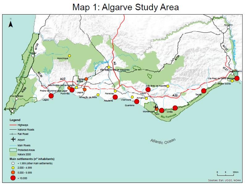
Algarve Tourism Products Assessment and Development Action Plan – Walking & Cycling Situation Analysis
Visitor data: There is no recent visitor data available, although CCDR has a relevant
set of information gathered in 2004.
Key issues & opportunities: A decision has now been taken to progress the Ecovia do
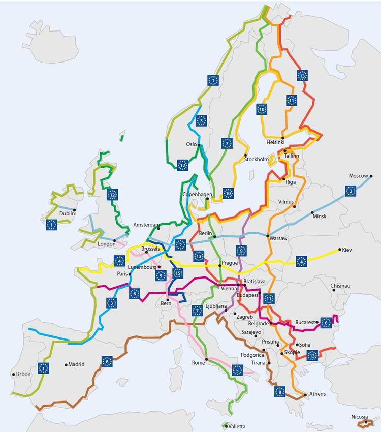
Litoral concept as part of the Eurovelo 1 route. All the countries along the route from
Norway to Portugal met in November 2015 in Westport, Ireland to decide what would
be needed to enable Eurovelo #1 (Atlantic Route)[2]. The route will run from Norway,
through UK, Ireland, France and via Salamanca south along Guadiana to Villa Real
do Santo Antonio and to Cape St Vincent. Ideally, according to the Portuguese
Cycling Federation, it should then run from there 700km north along the Rota
Vicentina to Lisbon and the north of Portugal. This route will be identified by the end
of November 2015 and there needs to be validation/buy-in from the local authorities.
The route would likely the Rota Vicentina Historical Way but not on the same route to
avoid user conflict and carrying capacity issues.
The EuroVelo 1 project is being prepared by Conseil Général des Pyrénées Atlantiques
and involving European Cycling Federation and all the relevant countries. It is likely
that there will be around €1m funding for the Portuguese section. The project will be
supported by AMAL, municipal councils, Turismo do Algarve, ATA and possibly Turismo
do Portugal who will focus on:
Project management
Development of a stakeholder organisation including private sector
Make EV1 a memorable destination of excellence
Make cycling trips on EV1 easy and attractive (services and signage)
Make the success visible through quantified economic evaluation
In the short term to enable the project there needs to be provision of basic information
to manage the expectations of those arriving and undertaking the route. The easiest
way is to provide a website and to provide online information on alternative routes to
the N125 segments. A Portuguese engineer, Paulo Guerra dos Santos is an expert in
this and could complete this for a small fee.[3]. In the mid-term, and in tandem with
the French there needs to be marketing, monitoring, social media and upskilling of
businesses along the route (enabling friendly communities). The cost for this would be
around €170,000 some of which could be sourced from European funding. Both the
Algarve Tourism Association (ATA) and Turismo do Algarve have buy-in to the Ecovia
and are providing €100k towards social media, and promotion. The reality is that
people’s expectations need to be managed as many are already doing the route.
Providing signage for the whole route would cost around €400,000.
In the long term the Ecovia should also be part of the 6,000km Eurovelo #8
(Mediterranean Route) from Cyprus to Cape St Vincent2. The European Cycling
Federation have said the Ecovia could be part of two Eurovelo routes.
2
http://www.eurovelo8.com/stages
7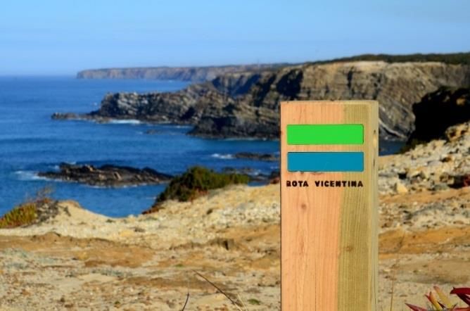
Algarve Tourism Products Assessment and Development Action Plan – Walking & Cycling Situation Analysis
The best section of the route now is the Villa Real do Santo Antonio to Brias do Sul to
the west of Olhao. This is around 70km i.e. a day ride. This would require additional
signage but could be launched as a Phase 1.
An indicative timescale, with sufficient financial resources, would be:
Q1/2 2016: Commission online version of current useable route with
downloadable GPS tracks and optimum route from Paulo Guerra dos Santos
or similar.
Q3/4 2016 – end 2017: Develop new signage standard for Ecovia and
implement
Q3/4 2016 – end 2019: Activate new management model for Ecovia and new
marketing tools including website, maps and guides.
Mountain-biking: There are three long distance mountain-biking routes in the Algarve
– the Via Algarviana, the Grande Rota do Guadiana and the Historical Way on the
Rota Vicentina can be completed on a mountain-bike by an intermediate rider.
The Via Algarviana website and guidebook include information, including GPS, for the
mountain-biking route. It is recommended that the route is ridden from Alcoutim to
the Cape and completed over 5 days. The recommended stages are shown below
in Figure A-4.
Figure A-4: Via Algarviana MTB Stages
Stage Distance Accumulated Accumulated
Ascent (m) Descent (m)
Alcoutim-Vaqueiros 58.8 1583 1352
Vaqueiros-Salir 58.88 2325 2317
Salir-Silves 63.1 1708 1950
Silves-Marmelete 42.9 2083 1709
Marmalete-Cabo 77.84 1140 1489
S.Vicente
A1.3.2 Local Cycling Routes
Touring/road: There are no official local road cycling routes. There are a range of
routes promoted by companies such as Megasport or in publications such as ‘Cycling
the Algarve’3. One of the routes in this guide book, shown below in Figure A-5, is a
329km six-day touring circuit through the western half of the region which includes
overnight stops, rides through quiet countryside and forested hills, visits to beaches
and dramatic coastal scenery. The sectors for this ride which starts and finishes in Silves,
include:
Silves-Monchique 37km
3
Cycling the Algarve, Huw Thomas, Pedal Portugal, 2015
8Algarve Tourism Products Assessment and Development Action Plan – Walking & Cycling Situation Analysis
Monchique-Zambujeira 53.5km
Zambujeira-Aljezur 49.5km
Aljezur-Sagres 60.3km
Sagres-Lagos 54.7km
Lagos-Silves 73.5km
This guide also indicates ten day rides at Aljezur, Boliqueime, Lagos, Mexilhoeira
Grande, Monchique, Silves and Zambujeira.
From undertaking the product audit it can be observed that the quality of the road
surface in much of the rural hinterland of the Algarve in combination with a relative
lack of traffic, provide very good conditions for the development of rural long
distance cycle routes.
Figure A-5: Algarve Touring Circuit (Pedal Portugal)
Mountain-biking routes: There are at least 37 signposted local mountain-biking routes
in the Algarve region:
19 of the Odiana walking routes can also be completed by mountain-bike (see
Figure A-17 below)
11 of the Via Algarviana Complementary Paths can be used by mountain-bikes
(all except PR2 PTM) (see Figure A-5 above)
3 of the Via Algarviana thematic routes can be completed by mountain-bike
– Rota da Geologica: Trail 2 – Foia and surrounding area (15.3km) and Rota
das Arvores Monumentais: Picota Circuit (27km) and Foia Circuit (17km)
9Algarve Tourism Products Assessment and Development Action Plan – Walking & Cycling Situation Analysis
Loule Municipal Council have published a guide to mountain-biking (BTT)
routes within their area. This guide indicates four trails as shown in Figure A-6,
below. These are all loop trails, are all signposted and can be completed all
year round.
Figure A-6: BTT Routes in Loule Municipality
Route Distance Time
Ameixial 26km 1.5 hours
Salir 17km 1 hour
Cortelha 25km/14km 3hours/2 hours
Querenca 22.5km 2 hours
A1.3.3 Cycling Events
The Volta do Algarve (Tour of the Algarve) is a 5-stage 783km competitive road race
that has been staged since 1960 with 41 editions, as of 2015. This event was last staged
over 18-22nd February 2015.
Stage 1 Lagos-Albufeira 167km
10Algarve Tourism Products Assessment and Development Action Plan – Walking & Cycling Situation Analysis
Stage 2 Lagoa-Monchique 197km
Stage 3 Vila do Bispo-Cabo de Sao Vicente 19km
Stage 4 Tavira-Malhao 216km
11Algarve Tourism Products Assessment and Development Action Plan – Walking & Cycling Situation Analysis
Stage 5 Almodovar-Vilamoura 184km
Total distance 783km
There were twenty-two teams of eight (176) riders starting the race in 2015.
Issues and Opportunities:
The Volta do Algarve is part of the international racing circuit with many international
teams taking part as a training for the Spring Classic races. Turismo do Algarve have
been criticised for not investing to ensure the Volta do Algarve has been shown on
Eurosport since 2012 given this would include significant aerial video of the Algarve
region4.
A1.3.4 Bike Rental
Abilio Bikes – based in Tavira in the eastern Algarve. Has a range of machines
to rent by the day or month.
Sport Nautica – based at Tavira
Formosar – based at Faro
Bikawish – based at Vilamoura
Bikeland – based near Vilamoura
East Algarve Bike Hire – based at Monto Gordo
Fun River – based at Alcoutim, has around 20 road bikes and 4 mountain bikes,
plus kayaks. Can arrange one way drop off to VR do Santo Antonio.
Algarve Adventure – mountain bikes only but includes delivery.
Algarve Bike Hire – based in Armacao de Pera, a small town to the west of
Albufeira. Has road bikes and tourers as well as hybrids, mountain and city bikes
for hire. Offers a delivery and collection service for the whole of the Algarve
(free for immediate area, charge for wider area).
4
Consultation with Thomas Swift Metcalfe, October 2015
12Algarve Tourism Products Assessment and Development Action Plan – Walking & Cycling Situation Analysis
Avalanche – bike shop at São Brás de Alportel (north of Faro) that also offers
bike hire and free delivery in a 25km radius of the town. Has mountain bikes or
a choice of carbon or aluminium frame road bikes.
Easy Go Electric Bikes – a new company based in Lagos, free delivery of
electric bikes within a 10km radius.
Mountain Bike Adventure – based at Lagos
MegaSport – based near Loule (north of Faro) offers Giant road and
town/hybrid bikes – plus tandems (although these are more ‘fun’ rides than
serious machines). Delivers free within the Algarve.
Funbike – based at Boliqueime, north-east of Albufeira. Despite the name, they
have ‘serious’ mountain bikes and road bikes for hire.
Lisa Bikes – based in Estoi (north of Faro) and has road, MTB and ‘touring’
(hybrid) bikes to rent (including children’s bikes). Also has electric bikes. The
company also offers a range of cycle tours, both based based from one
location or touring the region.
Alternativtour – based at Monchique
Sagres Nautica – based at Sagres
A1.3.5 Regional Mountain-Biking Centre
The Portuguese Cycling Federation is currently selecting a site for a regional BTT centre
in the Algarve. Centros de BTT is a national project and have developed 10+ centres
in the north. There is a website and they are planning ones in Monchique and Sao Bras
de Alportel.
A1.4 Hiking/Walking Routes
The Algarve contains walking trails of such range and quality that they enable
international comparison. While each of the mountain areas are individually
renowned for walking, once the areas are grouped together it can be seen that this
region is exceptionally well endowed with walking trails from short walks to loop and
linear walks that take a few hours up to long distance multi-day walking routes that
take in outstanding views and historical features.
A1.4.1 Regional Hiking/Walking Routes
There are three long distance walking routes in the Algarve; Rota Vicentina, Via
Algarviana and the recently opened Grande Rota do Guadiana. The towns and
villages and the start and end of each stage are the places which will benefit most
from increased numbers of walkers and cyclists on each route.
13Algarve Tourism Products Assessment and Development Action Plan – Walking & Cycling Situation Analysis
Rota Vicentina
Trail Information: The Rota Vicentina is a corridor of activity along the Costa Vicentina
on the Algarve’s west coast. The route consist of two main trails, the Fisherman’s Trail
which runs from Porto Covo in Alentjo to Odeceixe in the Algarve and its 5
complementary circuits, the Historical Trail which runs from Santiago do Cacem in
Alentjo to Cabo Sao Vicente in the Algarve, and five circular routes. While Casas
Brancas, the earlier version of Rota Vicentina Association, was started in 2002 work to
implement infrastructure on the trails did not begin until 2008 and took 3 years. Rota
Vicentina officially opened in 2012. The Rota Vicentina consists of two trails:
The Fisherman’s Trail - follows the coast along cliff top paths traditionally used
by fishermen and is located within the Southwest Alentejo and Vicentina Coast
Natural Park. It comprises a total of 4 sections and 5 complementary circuits,
totalling 120 km.
The Historical Way - follows trails used by pilgrims, travellers and locals on their
journeys throughout the region. This trail is fully accessible to hikers and
mountain bikers, with stretches of cork tree forests, mountain ranges, valleys
and rivers. It comprises a total of 12 sections and 230 km.
Figure A-7: Rota Vicentina
There are four stages to the Fisherman’s Trail and four additional complementary
circuits as shown in Figures A-8 and A-9 below.
14Algarve Tourism Products Assessment and Development Action Plan – Walking & Cycling Situation Analysis
Figure A-8: Fisherman’s Trail Stages
Stage Start/end destinations Distance
(km)
1 Porto Covo – Vila Nova de 20
Milfontes
2 Vila Nova de Milfontes - 15
Amograve
3 Almograve – Zambujeira do 22
Mar
4 Zambujeira do Mar - Odeceixe 18
Figure A-9: Fishermen’s Trail Complementary Circuits
Circuit Name Distance
(km)
1 Circuito Praia de Odeceixe 9
2 Circuito Praia da Amoreira 6
3 Circuito Ponta da Atalaia 14
4 Circuito Pontal da 10
Carrapateira
5 Circuito Praia do Telheiro 6
There are 12 stages on the Historical Way as shown in Figure A-10 below.
Figure A-10: Historical Way Stages
Stage Start/end destinations Distance
(km)
1 Santiago do Cacem – Vale 18
Seco
2 Vale Seco – Cercal do Alentjo 23
3 Cercal do Alentjo – Porto Covo 18
(link to Fisherman’s Trail)
4 Cercal do Alentejo – S.Luis 21
5 S.Luis - Odemeira 25
6 Odemeira – S.Teotonio 19
7 S.Teotonio - Odeceixe 17
8 Odeceixe - Aljezur 18
9 Aljezur - Arrifana 12
10 Arrifana - Carrapateira 24
11 Carrapateira – Vila do Bispo 22
12 Vila do Bispo – Cabo de 14
S.Vicente
Circular Routes: There are five short loop routes at Almograve, S. Luís, Troviscais, Santa
Clara and Sabóia in Alentjo. These are 3.5km to 13km in length.
15Algarve Tourism Products Assessment and Development Action Plan – Walking & Cycling Situation Analysis
Management organisation/funding: Rota Vicentina Association for the Promotion of
Nature Tourism in the Alentejo and Vicentina Coast
(www.rotavicentina.com), is a non-profit organisation founded in June
2013 that is responsible for the project Rota Vicentina. The association
Casas Brancas was the coordinator of the project in its implementation
phase, in partnership with the association Almargem, the local
municipalities and parish councils, local and regional entities, companies and
individuals that have supported the project and made it a viable proposition. This is
the most significant network of public and private partners, united in a joint initiative
in the region.
Rota Vicentina Association (RVA) is seen as more inclusive than Casas Brancas and
now has over 150 members with more applying to join every week. Members include
accommodation providers, tour operators and taxi companies. Membership fees are
now almost double the amount of annual public sector funding from municipal
councils meaning the RVA business model is becoming increasingly sustainable. The
amount each local authority pays is based on the number of stage stops (overnight
stops) they have in their area with a minimum of 3 as this is where people stay and
where councils generate the most income from visitors. Funding also comes from
sponsorship e.g. Europcar.
Maintenance of the trail is underpinned by a strong volunteer network who sponsor a
section of 20km+ and walk it twice a year, reporting problems or carrying out
maintenance themselves. Significant maintenance is undertaken by the municipal
councils.
The objectives of the Rota Vicentina Association are to:
Establish south-west Portugal as an international nature tourism destination,
raising awareness of the environmental and cultural significance of the region
Regulate the passage of walkers through environmentally sensitive areas
Consolidate development network (companies, institutions, population)
Present the region with a public infrastructure for the enjoyment of nature,
getting tourists close to the local population
Stimulate the existing offer during the medium/low season and contribute to
the sustainability of rural areas by creating new business opportunities5
5
Rota Vicentina Association, 2015
16Algarve Tourism Products Assessment and Development Action Plan – Walking & Cycling Situation Analysis
Signage: The Rota Vicentina has very high
quality directional, orientation and
interpretation signage. There are 26
interpretation panels in villages - the
start/end points of 22 sections and on 5 loop
trails.
Information available: Very high quality and
highly informative website with maps
available to download in all formats for all
sections including GPS, GPX and KMZ
formats for use in Google Earth and Google Maps. High quality printed maps and
guides are also available. Innovative features of the website include online booking
facility for accommodation; and an itinerary planner linked to an algorithm that
suggests an itinerary based on the user profile and length of stay.
Visitor data available: None available
Key issues & opportunities:
Although all of the Historical Way can be cycled Rota Vicentina Association
prefer not to promote this due to the potential for user conflict. This means there
is a need for a complementary cycle route in response to significant demand.
Rota Vicentina Association aim to extend the Rota Vicentina to Lagos in the
next two years. This would enable visitors to fly to Faro and get the train to Lagos
and the start of the Rota Vicentina.
A lack of visitor data makes prioritised investment difficult. Numerical,
qualitative and carrying capacity monitoring would enable RVA to work with
sponsors, media and EU funds – it would provide justification for investment. A
baseline socio-economic study and carrying capacity study are considered
essential.
While the route has world class information provision it currently lacks an app
to provide information on what can be seen and done.
Via Algarviana
Trail Information: Via Algarviana (GR13) is a 300km walking and mountain-biking route
from near the Guadiana River at Alcoutim in the Algarve’s north-east to Cabo Sao
Vicente in the south-west. The route runs through the mountains of Serra do Caldeirão
and Serra de Monchique. The concept of Via Algarviana was begun as a
collaborative effort between Almargem and the local group Algarve Walkers in 1995
but the trail was not completed until 2009. The path has its origins in an old religious
trail followed by pilgrims heading for the Sagres promontory, where the relics of St.
Vincent were found.
17Algarve Tourism Products Assessment and Development Action Plan – Walking & Cycling Situation Analysis
Figure A-11: Via Algarviana Route Map
Stages: There are 14 stages to the Via Algarviana, some of which can be combined
depending on the fitness of the walker as shown in Figure A-12 below.
18Algarve Tourism Products Assessment and Development Action Plan – Walking & Cycling Situation Analysis
Figure A-12: Via Algarviana Stages
Stage Start/end destinations Distance Time
(approx.)
1 Alcoutim to Balcuros 24.2km 7 hours
2 Balcuros to Furnazinhas 14.3km 4 hours
3 Furnazinhas to Vaqueiros 20.3km 6 hours
4 Vaqueiros to Cachopo 14.88km 4 hours
5 Cachopo to Barranco do 29.10km 8 hours
Velho
6 Barranco do Velho to Salir 14.9km 5 hours
7 Salir to Alte 16.2km 7 hours
8 Alte6 to Messines 19.3km 5 hours
9 Messines to Silves 27.6km 8 hours
10 Silves to Monchique 28.6km 8 hours
11 Monchique to Marmelete 14.7km 4 hours
12 Marmelete to Bensafrim 30km 7 hours
13 Bensafrim to Vila do Bispo 30.19km 8 hours
14 Vila do Bispo to Cabo 16.6km 5 hours
S.Vicente
Total 300.87
Links: There are now 5 linking trails which connect the Via Algarviana to nearby urban
settlements and train stations. These include:
Link 1: Parises - São Brás de Alportel 18.4km 5 hours
Link 2: Loule Train station – Salir 28.2km 7 hours
Link 3: Train station of Mexilhoeira Grande – Monchique 25.4km 6.5 hours
Link 4: Train station of Lagos – Bensafrim 10.1km 2.5 hours
Link 5: Marmelete – Aljezur 18.6km 5 hours
Complementary Routes: There are 12 looped trails promoted along with the Via
Algarviana, with good quality printed maps. These routes, are shown in Figure A-13
below, with those in bold starting alongside the Via Algarviana.
6
Via Algarviana official guide book incorrectly refers to this stage as Salir-Messines, page 63
19Algarve Tourism Products Assessment and Development Action Plan – Walking & Cycling Situation Analysis
Figure A-13: Complementary Routes on the Via Algarviana
Reference Name Start/end point Distance/Time
PR9 CTM Percurso Pedestre “Mina e Furnazinhas 7.7km/2-3 hours
Albufeira”
PR10 CTM Percurso Pedestre Furnazinhas 7.8km/2-3 hours
“Barrancos”
PR1 SLV Percurso Pedestre Cultural São Bartolomeu de 12.5km/3-4 hours
de São Bartolomeu de Messines
Messines
PR1 PTM Percurso Pedestre “A Mexilhoeira 7.5km/2 hours
Rocha Delicada” Grande
PR2 PTM Percurso Pedestre “Ao Alvor 4.7km/1.5 hours
Sabor da Maré”
PR2 MCQ Caminho das Caldas - Caldas near 18km/5 hours
Picota Monchique
PR3 MCQ Trilho da Fóia Fóia 6.5km/2 hours
PR4 MCQ Trilho dos Moinhos Monchique 10.3km/3hours
PR5 MCQ Percurso Pedestre das Fóia 17km/5 hours
Cascatas
PR6 MCQ Percurso Pedestre de Marmelete 8.4km/2.5-3 hours
Marmelete
PR1 LGS Percurso Pedestre "Pedra B. S. João National 6.1km/1.5 hours
do Galo" Forest Crossroad
PR4 VBP Percurso Pedestre "Pelas Raposeira 13.7km/4 hours or
Encostas da Raposeira" 18.2/5 hours
In order to increase the attractiveness of Via Algarviana (GR13) four new thematic
routes with twelve walks were developed with associated directional, interpretive
signs and very informative digital guides, these are shown in Figure A-14, below. These
include:
Rota do Contrabandista (Alcoutim)
Rota da Água (Loulé)
Rota das Árvores Monumentais (Monchique)
Rota da Geologia (Monchique)7
7
http://www.viaalgarviana.org/index.php/guias-rotas-tematicas/?lang=en
20Algarve Tourism Products Assessment and Development Action Plan – Walking & Cycling Situation Analysis
Figure A-14: Via Algarviana Thematic Routes
Rota do Walking Route of Alcoutim 5.5km/2.5 hours
Contrabandista Lourinhã
Walking Route of Pontal Viewpoint 6km/3 hours
Pontal
Rota do Agua Walking Route of Bus stop square at 3.6km
Olho Pariz Amendoeira
Walking Route of Fonte Benémola 1.3km
Benémola
Walking Route of Barranco do 5km
Barranco do Velho Velho
Walking Route of Moinho da 0.4km
Chavachã Chavachã
Walking Route of Near Almarginho 3.6km
Almarginho
Rota da Agua Trail 1 - Marmelete Marmelete 6.22km
Trail 2 – Foia and Near Fóia 15.3km
surrounding area
Rota das Town Circuit Monchique 6.3km
Arvores Picota Circuit Tourist Office 27km
Monumentais
Foia Circuit 17km
Management organisation/Funding: The Via Algarviana is managed by Almargem
and mainly dependent on funding from Municipal Councils with some grant funding
from Turismo do Algarve.
Signage: The Via Algarviana is signposted
with directional sign poles and arrows and
interpretation panels. These all use the GR13
identification. Interpretation panels are
installed at the beginning and end of each
sector to inform walkers about the natural
and cultural heritage, and accommodation
and food available.
Information available: Detailed maps and guidebook available from Almargem,
website for the route available at www.viaalgarviana.org which also hosts links for
downloading 14 sector maps, 5 link maps, 12 Pequenas Rotas maps, and 4 thematic
routes. The guide for Via Algarviana and GPS track can also be downloaded from the
website.
Visitor data available: None available
21Algarve Tourism Products Assessment and Development Action Plan – Walking & Cycling Situation Analysis
Key issues & opportunities:
Almargem have received two tranches of European funding for the Via
Algarviana and would be unlikely to gain a third. A sustainable funding
model is needed, similar to Rota Vicentina Association.
Lack of accommodation options, particularly in the east.
Lack of visitor data means investment cannot be prioritised
Need for more & upgraded signage
The website would benefit from investment & upgrading and better
imagery, more information on accommodation including booking options,
and more information on public transport with timetables.
Grande Rota do Guadiana
Trail Information: The Grande Rota Do Guadiana (GR15) runs 65k from Alcoutim to Villa
Real de Santo Antonio along the Guadiana River. The route was launched in
November 2014. The trail was developed by Odiana Association which is funded as a
rural development association by the municipal councils of Alcoutim, Castro Marim
and VR. De Santo Antonio. Odiana also manage 19 walking routes which can also be
mountain-biked, as can the Grande Rota do Guadiana. The trail does not follow the
line of the river due to a requirement by the municipal councils that only public land
be used. This has meant 19.5% of the route is on-road.
22Algarve Tourism Products Assessment and Development Action Plan – Walking & Cycling Situation Analysis
Figure A-15: Grande Rota do Guadiana route
Source: http://pt.wikiloc.com/wikiloc/view.do?id=8376543
Stages: There is a lack of online information regarding recommended stages, services,
accommodation or activities along the route. There are no defined stages for the
route.
Circuits: There are eight shorter circuits along
the Grande Rota do Guadiana, also
managed by Odiana Association.
Management organisation: Odiana
Association were responsible for the route
development and are now responsible, along
with the municipal councils, for trail
maintenance.
Information available: While a map of the trail
is available at http://www.wikiloc.com/wikiloc/view.do?id=8376543# there is no
printed map, downloadable maps, guides or website available.
Signage: The trail has high quality directional and orientation signage.
Visitor data available: None available
23Algarve Tourism Products Assessment and Development Action Plan – Walking & Cycling Situation Analysis
Key issues & opportunities:
Odiana would like to see the Grande Rota do Guadiana expand to the north
into Alentjo They already have an agreement with Alentjo for this. The link
would link to the Camino do Santiago, and to an area with different identity,
environment, people and gastronomy.
Funding for development and promotion is difficult as Odiana cannot become
an associative model like RVA due to it being funded by the public sector.
Need for visitor monitoring to enable targeted investment and to attract
development funding.
Alcoutim Municipal Council plan to develop a cycle route to the border with
Castro Marim Municipal Council – opening the opportunity for a cycle route
that follows the route of the Grande Rota do Guadiana making it a corridor of
activity as with Rota Vicentina.
Key priorities for Odiana in relation to the Grande Rota do Guadiana would be
the development of an app, a high definition promotional video, high quality
maps, and increased attendance at trade fairs to promote the trail.
A1.4.2 Local Hiking/Walking Routes
There are a significant number of local hiking/walking routes ranging from thirty
minutes to a full day.
Thirty-four trails are promoted via Turismo do Algarve’s publication ‘Guide to Walking
Trails in the Algarve’ which are shown in Figure A-16 below. This selection of walks
includes ones managed by Odiana Association, In Loco, INCF and several municipal
councils or combinations of these entities. While the prioritising of walks could make
sense there are several issues with this publication including:
Poor quality publication: The publication is not of sufficient quality to allow
international comparison – the maps are unclear and starting points of walks
are, in general, impossible to find without associated use of GPS. The
publication has included a great deal of text and images but does not include
information that is of most value to walkers such as accommodation or profile
data.
Poor quality signage: Most walks apart from those managed by Odiana lack
either orientation signage, directional signage or both. In some cases where
interpretative signage has been installed this has been installed facing the sun
and has burnt away e.g. Nature Discovery Trail of the Marim Environmental
Centre. In many cases orientation signage has been installed but there is no
associated directional signage meaning visitors, having found the start of the
walk, do not know which way to go.
Many walks are not located in close proximity to settlements or visitor hubs. This
is where the most economic benefit is likely to be realised, where infrastructure
should be concentrated, and where marketing efforts focussed.
24Algarve Tourism Products Assessment and Development Action Plan – Walking & Cycling Situation Analysis
Many existing walks have not been included in this publication such as:
Twelve of the nineteen Odiana Association routes (see Figure A-16 below
for Odiana routes)
Seven of the nine In Loco Association routes (see Figure A-17 below for In
Loco routes)
Five links and some of the twelve circuits on the Via Algarviana;
Five loops on the Fisherman’s Trail on the Rota Vicentina
Coastal walks such as Lagos to Salema, Salema to Sagres and Carvoeiro
to Benagil – which include some of the most scenic coastal walking in the
Algarve
Many Pequenas Rotas (PR routes) developed by the sixteen municipal
councils. Some of the walks developed by Loule Municipal Council have
been included in a publication by them which also includes four mountain-
biking routes. The walking routes are shown in Figure A-16 below.
Figure A-16: Walking Routes Promoted in Turismo do Algarve’s ‘Guide to Walking Trails in
the Algarve’
Type of walk Name Town/Municipality Distance/Time Responsibility Associated
(loop/linear)/User Long
(walk/MTB/horse) Distance
Trail
West Coast
Loop - walk Trail of Borderia, Aljezur 14km/4.5hrs Borderia Parish Rota
Aromas Office Vicentina
Loop - Trail of Tides Carrapateira, 19km/7hrs Borderia Parish Rota
walk/MTB/horse Aljezur Office Vicentina
Loop - walk Casteljo Casteljo 3.5km/1hr30 Vila do Bispo Rota
Environmenta Environmental Parish Office Vicentina/
l Trail Area, Vila do Bispo Via
Algarviana
The South Coast
Loop - walk At the Whim Alvor, Portimao 5km/2hr Portimao Ecovia do
of the Tides Municipal Litoral
Council
Loop - walk Rocha Quinta da Rocha, 7km/2hr Portimao Ecovia do
Delicada Trail Portimao Municipal Litoral
Council
Linear - walk Praia Grande Praia Grande, 5.5km/2hr CCDR-Algarve Via
Interpretation Silves Algarviana
Trail
Linear - walk Sao Lourenco Quinta do Lago, 3.4km/1hr30 Quinta do Lago, Via
Trail Loule Loule Municipal Algarviana
Council, PNRF
and Infraquinta
Linear - walk Ilha da Ilha da Cultura, 5.6km/2hr Ria Formosa Ecovia do
Cultura Trail Faro Natural park, Litoral
25Algarve Tourism Products Assessment and Development Action Plan – Walking & Cycling Situation Analysis
Type of walk Name Town/Municipality Distance/Time Responsibility Associated
(loop/linear)/User Long
(walk/MTB/horse) Distance
Trail
Faro Municipal
Council,
Ambifaro
Loop - walk Nature Quinta da Marim, 3km/1hr30 ICNF (Ria Ecovia do
Discovery Trail Olhao Formosa Natural Litoral
of the Marim Park)
Environmenta
l Centre
Linear - walk Praia do Barril Pedras d'El Rei, 3km/1hr15 Tavira Municipal Ecovia do
Trail Tavira Council and ICN Litoral
(Ria Formosa
Natural Park)
Barrocal
Linear - walk Sitio das Sitio das Fontes, 1.2km/30mins Lagoa Municipal No
Fontes Lagoa Council
Municipal
Park Trail
Loop - walk Paderne Paderne, Albufeira 4.5km/1hr30 CCDR-Algarve No
Castle Trail
Loop - walk Cerro de Sao Paderne, Albufeira 11km/3hr30 Albufeira No
Vicente Trail Municipal
Council
Loop - walk Rocha da Rocha da Pena, 6.4km/2hr Loule Municipal Via
Pena Trail Loule Council Algarviana
Loop - walk Fonte Fonte Benemola, 4.4km/1hr30 Loule Municipal Via
Benemola Loule Council Algarviana
Trail
Loop - walk A Walk to the Fonte de Mesquita, 9km/3hr Sao Bras de No
Spring Sao Bras de Alportel
Alportel Municipal
Council
Serra
Loop - walk Discovering Mata de Barao de 12km/4hr Lagos Municipal Via
the Forest - Sao Joao, Lagos Council Algarviana
Red Trail
Loop - walk Discovering Mata de Barao de 6km/2hr Lagos Municipal Via
the Forest - Sao Joao, Lagos Council Algarviana
Lilac Trail
Loop - walk Foia Trail Foia, Monchique 7km/2hr30 Monchique Via
Municipal Algarviana
Council
Loop - walk Lagoao Trail Sao Marcos da 10km/3hr30 Silves Municipal Via
Serra, Silves Council Algarviana
Loop - walk Masmorra Mealha, Tavira 5.5km/2hr In Loco No
Trail Association and
26Algarve Tourism Products Assessment and Development Action Plan – Walking & Cycling Situation Analysis
Type of walk Name Town/Municipality Distance/Time Responsibility Associated
(loop/linear)/User Long
(walk/MTB/horse) Distance
Trail
Tavira Municipal
Council
Loop - walk D.Quixote Casas Baixas, 17km/6hr In Loco Via
Trail Tavira Association and Algarviana
Tavira Municipal
Council
Loop - walk Reserva Trail Feiteira, Tavira 5.2km/2hrs In Loco Via
Association and Algarviana
Tavira Municipal
Council
Loop - walk Barranco das Cabanas, Sao Bras 5.5km/2hr Sao Bras de No
Lajes Trail de Alportel Alportel
Municipal
Council
Loop - walk Between Parises, Sao Bras de 20km/7hrs Sao Bras de No
Valleys, Alportel Alportel
Springs and Municipal
Memories of Council
the Serra do
Caldeirao
Guadiana
Loop - walk/MTB Uphill, Vaqueiros, 13km/4hr30 Odiana Grande
downhill Alcoutim Association and Rota do
Alcoutim Guadiana
Municipal
Council
Loop - walk/MTB Ladeiras do Miradouro do 13.5km/4hr30 Odiana Grande
Pontol Pontal, Alcoutim Association and Rota do
Alcoutim Guadiana
Municipal
Council
Loop - walk Flow Flow, Laranjeiras, 8.5km/3hr Odiana Grande
Guadiana Alcoutim Association and Rota do
Alcoutim Guadiana
Municipal
Council
Loop - walk/MTB Terras da Terras da Ordem 12.5km/4hr Odiana Grande
Ordem Trail National Forest, Association and Rota do
Castro Marim Alcoutim Guadiana
Municipal
Council
Loop - walk/MTB Amendoeira Alta Mora, Castro 11km/4hr Odiana Grande
Trail Marim Association and Rota do
Alcoutim Guadiana
27Algarve Tourism Products Assessment and Development Action Plan – Walking & Cycling Situation Analysis
Type of walk Name Town/Municipality Distance/Time Responsibility Associated
(loop/linear)/User Long
(walk/MTB/horse) Distance
Trail
Municipal
Council
Loop - walk/MTB A window on Azinhal, Castro 7.5km/2hr30 Odiana Grande
the Marim Association and Rota do
Guadiana Alcoutim Guadiana
Municipal
Council
Linear - walk/MTB Venta Interpretation 7km/2hr Nature Reserve Grande
Moinhos salt- Centre, Castro of the Castro Rota do
marsh Trail Marim Marim and Vila Guadiana
Real de Santo
Antonio Salt
Marsh and the
Castro Marim
Municipal
Council
Loop - walk/MTB Boa Vista Trail Corte Antonio 9km/3hr Odiana No
Mountains, Vila Association and
Real de Santo Alcoutim
Antonio Municipal
Council
Figure A-17: Walks & BTT routes developed and managed by Odiana Association
Name Location Distance Mode Link with Long
Distance Trail
Alcoutim
PR1 Corre, Core Larenjeiras 8km Walk/BTT Grande Rota do
Guadiana Guadiana
PR2 Ladeiras do Alcoutim 14km Walk/BTT Grande Rota do
Pontal Guadiana/Via
Algarviana
PR3 Os Encantos de Alcoutim 4km Walk/BTT Grande Rota do
Alcoutim (The Guadiana/Via
Delights of Algarviana
Alcoutim)
PR4 Caminhos da Aldeia do 10km Walk/BTT No
Fonte (The Pereiro
Fountain Route)
PR5 O Vicoso Gioes 12km Walk/BTT No
PR6 Memoria Viva Martinlongo 13km Walk/BTT No
(Living Memory)
PR7 Cerro Acima, Vaqueiros 13km Walk/BTT No
Cerro Abaixo (Up
28Algarve Tourism Products Assessment and Development Action Plan – Walking & Cycling Situation Analysis
Name Location Distance Mode Link with Long
Distance Trail
the Hill, Down the
Hill)
PR8 Em Busca do Vaquerios 13km Walk/BTT Via Algarviana
Vale Encantado
(In Search of the
Enchanted
Valley)
Castro Marim
PR1 Do Passado ao Castro Marim 3km Walk/BTT Grande Rota do
Presente (From Guadiana
the Past to the
Present)
PR2 Circuito do Beliche 7km Walk/BTT No
Beliche (Circuit of
Beliche)
PR3 Uma janela paro Azinhal 6km Walk/BTT Grande Rota do
o Guadiana Guadiana
PR4 Odeleite de Odeleite 11km Walk/BTT Grande Rota do
Perto e de Longe Guadiana
PR5 Terras da Ordem Odeleite 12km Walk/BTT Grande Rota do
Guadiana
PR6 Canaviais Corte 7km Walk/BTT No
Barranco do Pequena
Ribeirao
PR7 Caminhos da Cruz de Alta 15km Walk/BTT No
Cabra Algarvia Mora
PR8 Caminho da Cruz de Alta 11km Walk/BTT No
Amendoeira Mora
Vila Real Santo Antonio
PR1 Boa Vista Corte Antonio 10km Walk/BTT No
Martins
PR2 Quintas de Villa Nova de 7.5km Walk/BTT No
Cacela Cacela
PR3 Passeio Villa Real do 3km Walk Grande Rota do
Pombalino Santo Antonio Guadiana/Ecovia do
(Pombaline Litoral
Walk)
29Algarve Tourism Products Assessment and Development Action Plan – Walking & Cycling Situation Analysis
Figure A-18: Walks developed and managed by In Loco Association
Name Location Distance Mode Link with Long
Distance Trail
PR1 Don Quixote Casas Baixas 16.9/10.5km Walk Via Algarviana
Walk
PR2 Fonte da Zorra Casas Baixas 5km Walk Via Algarviana
Walk
PR3 Montes Serranos Casas Baixas 9km Walk Via Algarviana
Walk
PR4 Cerros da Sobro Feiteira 14.3km Walk Via Algarviana
Walk
PR5 The Reserve Feiteira 6km Walk Via Algarviana
PR6 Malhanito Feiteira 9km Walk Via Algarviana
PR7 Vale das Hortes Mealha 13.5km Walk No
PR8 Masmorra Mealha 6km Walk No
PR9 Burial Chamber Mealha 10km Walk No
of Pedras Altas
Figure A-19: Walks developed by Loule Municipal Council
Name Location Distance Mode
Pe do Coelho Pe de Coelho 8.5km Walk
Rocha da Pena Pena 5km Walk
Barranco do Velho Barranco do Velho 5.5km Walk
Tor Tor 5km Walk
Querenca Querenca 9km Walk
Fonte Benemola Querenca 4.5km Walk
Azinhal dos Mouros Azinhal dos Mouros 13km Walk
Revezes Ameixhal 12.5km Walk
Montes Novos Montes Novos 9km Walk
Vale da Rosa Vale da Rosa 9km Walk
Parque Natural da Ria Quinta do Lago 9km Walk
Formosa
A1.4.3 Town Trails
There are town trails in Loule, Faro and Villa Real de Santo Antonio which have some
information available in terms of printed maps but have not been signposted. Given
the historical natural of many cities and towns in the Algarve there is significant
potential for the development of historic town trails.
30Algarve Tourism Products Assessment and Development Action Plan – Walking & Cycling Situation Analysis
A1.5 Visitor Facilities
A1.5.1 Visitor Accommodation
There is a wide range of visitor accommodation in the Algarve. This includes
Hotels
Self-catering
Privately owned holiday homes and apartments
The number and locations of hotels are shown below in Figure A-20. This shows the
primary hotel accommodation centres are Albureria/Olhos d'Água, Lagos,
Vilamoura/Quarteira, Monto Gordo, Portimao, Faro, Alvor, Carvoeiro, Almancil,
Porches and Monchique.
Observations are that, as expected the greatest concentration of accommodation is
located along the southern coast and primarily between Quarteria/Vilamoura and
Lagos. Albureria/Olhos d'Água has the greatest concentration of hotels with 52 hotels
and resorts.
Figure A-20: Hotels and Resorts in the Algarve
Area 1*Hotel 2*Hotel 3*Hotel 4*Hotel 5*Hotel 3*Resort 4* 5* Total
Resort Resort
Albufeira 8 12 13 2 1 4 2 42
Lagos 3 4 4 2 13
Vilamoura 4 7 1 1 13
Monto Gordo 9 2 11
Portimao 3 2 3 1 1 11
Faro 1 5 2 2 10
Olhos d'Água 4 4 2 10
Quarteira 6 2 8
Alvor 6 2 8
Carvoeiro 5 2 7
Almancil 1 3 2 6
Porches 1 3 1 1 6
Monchique 2 1 1 2 6
Sagres 1 3 1 5
Praia da Rocha 2 2 1 5
Tavira 3 1 4
Olhão 3 3
Quinta do Logo 1 1 1 3
Armação de 2 1 3
Pêra
Aljezur 2 2
31Algarve Tourism Products Assessment and Development Action Plan – Walking & Cycling Situation Analysis
Area 1*Hotel 2*Hotel 3*Hotel 4*Hotel 5*Hotel 3*Resort 4* 5* Total
Resort Resort
Altura 1 1 1 2
Loule 1 1 2
Praia Verde 2 2
Vila Real de 1 1 2
S.Antonio
Alcantarilha 1 1
Alte 1 1
Boliqueme 1 1
Burgau 1 1
Estrela do Vau 1 1
Faro Aeroporto 1 1
Ferragudo 1 1
Luz 1 1
Manta Rota 1 1
Moncarapacho 1 1 1
Montechoro 1 1
Montenegro 1 1
(Faro)
Pechão 1 1
Praia do 1 1
Carvoeiro
Praia do Vau 1 1
Rogil 1 1
Salema 1 1
Santo Estevão - 1 1
Tavira
São Clemente 1 1
Silves 1 1
Vale do Lobo 1 1
Vila do Bispo 1 1
Total 6 31 60 67 29 1 8 7
Source: Turismo do Algarve
A1.5.2 Visitor information centres
There are 20 visitor information centres in the Algarve, operated by Turismo do
Algarve. These are located at:
Posto de Informação Municipal de Faro
Turismo de Aeroporto Internacional
Posto de Informação Municipal de Lagos
Posto de Informação Municipal de Querença
Posto de Informação Municipal de Salir
32Algarve Tourism Products Assessment and Development Action Plan – Walking & Cycling Situation Analysis
Posto de Informação Municipal de Albufeira
Posto de Informação Municipal de Portimao
Posto de Turismo de Alcoutim
Posto de Turismo de Castro Marim
Posto de Turismo de Monchique
Posto de Turismo de Sagres
Posto de Turismo de São Brás de Alportel
Posto de Turismo de Silves
Posto de Turismo Loulé
Posto de Turismo Tavira
Posto de Turismo Vila Real de Santo Antonio
Posto de Turismo de Carvoeiro
Posto de Turismo de Praia da Rocha
Posto de Turismo de Lagos
Posto de Turismo de Aljezur
Many of these close for long lunch breaks and the quality of information on offer and
local knowledge with regards to the cycling and walking product offer varies
between each office.
In many office visitors are not being advised to complete the Ecovia do Litoral due to
its incompleteness. In general for walking trail information walkers are being referred
to the Turismo do Algarve walking trail publication which has several issues, please see
section 2.5.2 above.
33Algarve Tourism Products Assessment and Development Action Plan – Walking & Cycling Situation Analysis
Appendix 2: Consultation Programme Summary
Tourism Development International undertook a series of face to face consultations
during September and October 2015. These included those shown in Figure A-21
below.
Figure A-21: Consultees
Organisation Contact Name
ANA Aeroportos de Portugal Helder D. Lemos
Turismo de Portugal Carla Margarida Simões
Dr. Luis Matoso
Turismo do Algarve João Fernandes
Duarte Padinha
Algarve Tourism Association Dora Coelho
Faro Municipal Authority João Correia Vargues
Paulo Santos
Association of Hotels and Tourist Enterprises of Elidérico Viegas
Algarve (AHETA)
Association of Hotelier Industrial and Similar of Daniel do Adro
Algarve (AIHSA)
AMAL - Associação de Municipios do Algarve Jorge Coelho
Almargem-Associação de Defesa do Património Anabela Santos
Cultural e Ambiental do Algarve
Rota Vicentina Association Marta Cabral
Odiana Joana Germano
Federação Portuguesa de Ciclismo Sandro D. Araújo
Marco Fernandes
Algarve Regional Coordination and António Ramos
Development Commission (CCDR-Alg)
ARA (Associação das Empresas de Rent-a-car Armando Santana
do Algarve)
ARAC (Associação dos Industriais de Aluguer de Honorio Teixeira
Automóveis sem Condutor)
MEGASPORT (Portuguese Federation of Cycle Fernando Canteiro and Cristina
Tourism and Bicycle Users rep) Dias
Swift Momentum Sports Tomas Swift Metcalfe
Walkin’ Sagres Carla Cabrita
Proactive tour João Ministro
Live Love Ride Pedro Rocha
Hotel Vila Gale Lagos Sofia Ribeiro
University of Algarve Maria Joao Custorio
34You can also read