Landscape Proof of Evidence - Manor Farm, Templecombe - South Somerset District Council
←
→
Page content transcription
If your browser does not render page correctly, please read the page content below
Landscape Proof of Evidence
   Manor Farm, Templecombe
    PINS ref APP/R3325/W/20/3265558 LPA ref 19/03416/OUT

                                                      by

        Charles Potterton BA DipLA CMLI
                        Chartered Landscape Architect

                                            on behalf of

      South Somerset District Council
                                   Issued 13th April 2021
Contents
1. Introduction
2. Background and Reasons for Refusal
3. Baseline
4. The principle of development
5. Visual Impacts
6. Impact on Landscape Character
7. Mitigation measures
8. Consultation Response
9. Summary & Conclusions
Appendix 1 Methodology (This document)
Appendix 2 Figures (Separate document)
Fig 01 Photo locations
Fig 02 PLS Fig 02
Fig 03 PLS Fig 03
Fig 04 PLS Fig 05
Fig 05 Site areas
Fig 06 OS Map / aerial overlay
Photos 01-06
_____________________________________________________________
2
Manor Farm, Templecombe
PINS ref APP/R3325/W/20/3265558 LPA ref 19/03416/OUT
Charles Potterton – Landscape Proof of Evidence 13.04.20211.0 Introduction
1.1. My name is Charles Potterton. I am a Chartered Member of The Landscape
Institute and Director of Potterton Associates Ltd. I hold a BA Degree in
Landscape Architecture (1982), a Diploma in Landscape Architecture (1983)
and have been practicing as a Landscape Architect since 1984.
1.2. Potterton Associates Ltd was founded in 1992, is a Registered Member of the
Landscape Institute and trades as a Limited Company. During this time I have
carried out a significant number of visual impact assessments and character
appraisals on a wide variety of sites primarily in Worcestershire, Herefordshire
and Gloucestershire.
1.3. I am Chairman of the Conservation Advisory Panel, which advises Worcester
City Council on matters affecting the 11 Conservation Areas across the City of
Worcester. I am a member of the DESIGN : MIDLANDS design review Panel,
based in Birmingham.
1.4. I am also employed by Swindon Borough Council, as a Consultant Landscape
Architect and deal with landscape matters arising through the development
control process. I prepare consultation responses for all planning applications
that are deemed likely to have an impact on the landscape, including those
within the North Wessex Downs AONB. I previously was employed on a similar
basis with Bath and North East Somerset Council which includes the World
Heritage Site of the City of Bath.
1.5. I work with a number of other Local Authorities to include Malvern Hills District
Council, Herefordshire County Council and Mendip District Council. I work with
South Somerset District Council on a regular basis to include preparation of
Consultation Responses and, currently, advising on the ongoing SHLAA
process.
1.6. I was commissioned South Somerset District Council in June 2020 to assist
(SSDC) on the Landscape and Visual Impact (LVIA) elements of the original
application and my ‘Consultation Response’ was originally dated 19th June
and was based on the Rev G layout. My response was further amended on
22nd June in response to Rev I.
1.7. During the preparation of this document, I have used the following research
documents -
_____________________________________________________________
3
Manor Farm, Templecombe
PINS ref APP/R3325/W/20/3265558 LPA ref 19/03416/OUT
Charles Potterton – Landscape Proof of Evidence 13.04.2021§ All reports, plans and drawings (including appendices) submitted with the
application
§ Consultation responses
§ National, local and strategic planning policies
§ Guidelines for Landscape and Visual Impact Assessment (GLVIA 3)
§ South Somerset Landscape Character Assessment
§ The Landscape of South Somerset 1993
§ SSDC Peripheral Landscape Study – Templecombe 2008
§ Statements of Heritage Significance: Analysing Significance in Heritage
Assets (Historic England October 2019)
§ The Setting of Heritage Assets (Historic England December 2017)
1.8. The evidence that I have prepared, and provide in this document, is true and
has been prepared and is given in accordance with the guidance of my
professional institution and I confirm that the opinions expressed are my true
and professional opinions, irrespective of by whom I am instructed.
2.0 Background and Reasons for Refusal
2.1 The application is for ‘Outline application for the demolition of existing
buildings and residential development of 60 units including the creation of a
new vehicular access and pedestrian accesses, open space, landscape
planting and surface water attenuation (all matters reserved except
access)”.
2.2 The application was lodged on 26th June 2020 and a decision notice was
issued on 14 August 2020. Consent was refused and there were two reasons
for refusal.
2.3 This POE will focus on reason 1 and I have emphasised (underlined and bold)
what I consider to the key parts within each reason.
2.4 1. This is an outline application which seeks to establish the principle of
development and access. All other matters of appearance, landscaping,
layout and scale are reserved for future submission, consideration and
determination. An illustrative Masterplan no 19-025 406 Rev J has been
submitted indicating where and how the quantum of 60 dwellings could be
accommodated on the application site. The Council is of the opinion that,
whilst some residential development can be provided on parts of the site
without causing unacceptable detriment to landscape character and harm
_____________________________________________________________
4
Manor Farm, Templecombe
PINS ref APP/R3325/W/20/3265558 LPA ref 19/03416/OUT
Charles Potterton – Landscape Proof of Evidence 13.04.2021to visual amenity, there are other parts of the site, particularly on the eastern
and southern outer slopes where residential development is indicated on the
Masterplan and which the Council considers would cause an unacceptable
level of harm to the rural character of that part of the site and the wider
landscape.
Development in these areas would also cause an unacceptable level of harm
to the visual amenity of those receptors adjacent to the site as well as those
in the wider landscape. With that concern in mind, it is considered that the
illustrative Masterplan has not demonstrated that the proposed quantum of
residential development can be accommodated on the site without resultant
unacceptable levels of harms to the landscape and for which an overriding
essential need has not been justified. The Council is of the opinion therefore
that the presumption in favour of sustainable development does not apply in
this case.
As such, the proposal is contrary to Policies SD1 and EQ2 of the South Somerset
Local Plan 2006-2028. The adverse impacts are considered to significantly and
demonstrably outweigh the acknowledged benefits towards meeting the
Local Planning Authority's housing supply (including affordable housing
provision), and other social and economic benefits, having due regard to
paragraphs 11.d) ii. and 12 of the National Planning Policy Framework (2019).
2.5 2. This is an outline application which seeks to establish the principle of
development and access. All other matters of appearance, landscaping,
layout and scale are reserved for future submission, consideration and
determination. Nevertheless, an illustrative Masterplan no 19-025 406 Rev J has
been submitted indicating where and how the quantum of 60 dwellings could
be accommodated on the application site. The Council is of the opinion that
part of the site identified for provision of residential development would
extend too far north into the strategic views that are the setting of the nearby
Grade II* Listed Building (Manor Farm) and the erosion of its rural historic
character, resulting in 'less than substantial' harm being caused to the
designated heritage asset as described in paragraph 196 of the National
Planning Policy Framework. It is considered that the illustrative Masterplan has
not demonstrated that the proposed quantum of residential development
can be accommodated on the site without causing unacceptable detriment
to the character and setting of the designated heritage asset.
As such, the proposal conflicts with the Section 66 of the Planning (Listed
Building and Conservation Areas) Act 1990 and, in the absence of any public
_____________________________________________________________
5
Manor Farm, Templecombe
PINS ref APP/R3325/W/20/3265558 LPA ref 19/03416/OUT
Charles Potterton – Landscape Proof of Evidence 13.04.2021benefits that would outweigh such harm, is contrary to Policy EQ3 of the South
Somerset Local Plan 2006-2028 and Section 16 of the National Planning Policy
Framework (2019), in particular paragraphs 192, 193 and 196.
2.6 In summary, these reasons conclude that (my emphasis) -
• the Council considers that residential development on the eastern and
southern outer slopes would cause an unacceptable level of harm to
the rural character of that part of the site and the wider landscape.
• development in these areas would also cause an unacceptable level
of harm to the visual amenity of those receptors adjacent to the site as
well as those in the wider landscape.
2.7 My evidence will elaborate on each of these points in turn.
3.0 Baseline
3.1 The site is located on the south-eastern edge of Templecombe and covers
4.31 hectares. The site comprises four small open pasture paddocks,
agricultural buildings including a modern steel barns, areas of gravel,
concrete hardstanding and slurry pits.
3.2 The submitted LVIA describes the application site as being four separate fields.
It is actually one larger field which have been subdivided with post and wire
fencing to create four smaller paddocks.
3.3 The site is located to the east of the Combe Hill / A357 and the High St and
lies outside the defined settlement boundary of Templecombe and is
therefore, in policy terms. within open countryside.
3.4 Access is proposed from the existing access point in the southernmost corner,
from the A357, Combe Hill. It is understood that there will need to be some
amendments to this access point to include a footway. An additional
footpath is proposed from the corner of East St, across the open parts of the
site, leading to the area currently occupied by sheds.
_____________________________________________________________
6
Manor Farm, Templecombe
PINS ref APP/R3325/W/20/3265558 LPA ref 19/03416/OUT
Charles Potterton – Landscape Proof of Evidence 13.04.20213.5 The existing sheds and slurry pits are to be removed. There are external hedges
to the perimeter of the site, and these are to be retained. There is some
vegetation associated with the central slurry pit area and this is also to be
removed
3.6 The main access is at +/- 100m AOD and the farm buildings at +/- 97m. The
lowest point of the site, the n/e corner at the PROW junction with East St, is
approximately 83m AOD. This is the proposed location of the new footpath
entrance. The main buildings sitting on a distinct and prominent plateau
which accentuates their prominence in the local landscape.
3.7 The area to the immediate north and east of the farm buildings has previously
been levelled out to form the flat platform on which they sit. The west side of
the main shed digs slightly into the ground at its rear.
3.8 The site slopes from high on the west to low on the east,
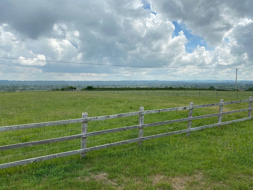
3.9 This an important and relatively exposed promontory that sits some 30m higher
than the wider landscape. The photo on the front of this POE illustrates the
relative prominence and importance of the site.
3.10 To the west of the site are a number of residential dwellings, ranging from
smaller bungalows towards the entrance, to Manor House midway along the
western boundary and around to the north where Templars Barton forms a
hard edge and then longer gardens to properties accessed off High St and
then, to the NE, a series of smaller cottages along East St.
3.11 To the east of the application site is generally open countryside comprising
mainly of grazed fields.
3.12 The eastern boundary of the site is not currently fenced or hedged and is a
relatively arbitrary (fenced) line across an otherwise open field.
3.13 Land to the south is in agricultural use as grazing land.
3.14 It is clear from historical mapping and physical evidence that most residential
development in the past has focussed on the west side of the A357 and not
on this more prominent and visually sensitive higher land to the east.
_____________________________________________________________
7
Manor Farm, Templecombe
PINS ref APP/R3325/W/20/3265558 LPA ref 19/03416/OUT
Charles Potterton – Landscape Proof of Evidence 13.04.20213.15 Public Rights of Way (PROW). There is a single PROW WN 29/12 that traverses
the open field neighbouring the site to its Eastern boundary, from
approximately NW to SE where it is in the ‘open’ for 350m and has clear views
of the site. Users of this PROW also have views of the gable end of Manor Farm.
3.16 Built structures. There are three agricultural buildings on the site. One smaller
standalone shed and two larger pitch roof sheds that sit side by side. These
are clearly visible from the wider landscape – see my photos 01-05 (Appendix
2). However, they are what one would expect to see on a farm, with the tallest
being circa 10m tall at its ridge.
3.17 Conservation Areas. There are no Conservation Areas near the site.
3.18 Listed buildings. The Manor House is Grade ii* listed. Matters of Heritage and
Archaeology are dealt with by Ms Wedd. It is clear that the appeal site forms
part of its landscape setting i.e. the area within which the building is
experienced.
3.19 Tree Preservation Orders. There are none relating to this site. I do not consider
that the loss of vegetation around the slurry tanks is in itself a concern as that
is generally ‘self-sown’, is not of particularly high quality and could be
replaced.
4.0 The principle of development
4.1 In my original response I did concur with a number of other studies, such as
the South Somerset ‘Peripheral Landscape Study’ (PLS) for Templecombe,
that this site has capacity for some development.
4.2 In that response I confirmed my opinion that whilst ‘some’ development may
be possible, the unique set of constraints provided by this site means that
density should not be any measure of acceptability or appropriateness.
4.3 During the application process, I included a number of diagrams showing
which parts of the site I considered could or could not be developed and
explained why in each case. I sub-divided the site into four areas (A-D) as
follows (see Fig 05 Appendix 2).
In respect of Area A, I consider that there is potential for development in this
_____________________________________________________________
8
Manor Farm, Templecombe
PINS ref APP/R3325/W/20/3265558 LPA ref 19/03416/OUT
Charles Potterton – Landscape Proof of Evidence 13.04.2021area but development must not move any further east than a line drawn
along the back of the existing shed. To move any further out would cause
significant visual harm (and harm to wider landscape character). The removal
of the farm buildings may be a benefit.
In respect of Area B, I consider that this is the most sensitive in terms of wider
visual impact and resulting harms to wider landscape character. There should
be no built development in this area and the focus must be providing
appropriate mitigation for any development on Area A.
An increase in boundary planting at the lower areas of the site will be least
successful in screening or filtering views of buildings that are located at a
higher level. In some cases, screen planting will be best located nearer to the
viewer (as opposed to nearer to the object being screened).
With Area C, I am aware that there is a combined and enhanced sensitivity
around archaeology and setting of the listed building. There is also a close
relationship with existing residential properties at Templars Barton. I do not
think there should be any built development in this sensitive area, but it does
need an appropriate soft landscape solution that addresses these issues.
Lastly, Area D. This is closely related to the properties along High St and East
St. It is also closest to the PROW. Having said that, it does sit much lower in the
landscape and I consider that there is some scope for built development
here. I am aware of the need to also balance and ‘feather into’ the issues
related to Area C and that will inevitably restrict development.
In my opinion, whilst I have identified that there is potential for some
development on the site, it does present a complex array of issues and
constraints that must be dealt with appropriately. In this regard, I find that the
current iteration of the scheme (drg 406 G) is focussed in the most sensitive
areas and is therefore unacceptable in its current format
4.4 It is clear that the applicant / appellant did not subsequently heed this advice
and persisted with a much greater extent of development than I considered
acceptable and this is encapsulated within Reason for Refusal 1
_____________________________________________________________
9
Manor Farm, Templecombe
PINS ref APP/R3325/W/20/3265558 LPA ref 19/03416/OUT
Charles Potterton – Landscape Proof of Evidence 13.04.20215.0 Visual Impacts
5.1 The photograph on the cover of this POE illustrates that this is in fact an
exposed site that sits on top of an exposed and prominent part of the local
landscape and the assertion in the submitted landscape report 3.68(h) that it
is ‘relatively well contained’ is incorrect.
5.2 The submitted LVIA also describes the application site as being four separate
fields. It is actually one larger field which have been subdivided with post and
wire fencing to create four smaller paddocks.
5.3 It is accepted that there are already houses on this ridge, but historically, they
have sat well back from the edge of the ridge and are relatively discrete in
the view. In addition, a number of these houses are bungalows and are
partially screened by existing hedging and taller trees.
5.4 It is my opinion that this ridge is an important part of the landscape character
of the area and that to extend built development some 130m further out from
the existing would cause significant visual harms. The proposed scheme does
not respect that ridge and, in my opinion, sits harmfully forward of it. I do not
believe that mitigation in the form of planting or building design can be
successful in reducing the harms caused.
5.5 The Templecombe Peripheral Landscape Study (PLS) notes (6.4) that where
buildings have been built on sloping ground ‘an adverse visual impact of
building mass is clear. It is also accepted that building over steep slopes is
contrary to sustainability objectives, for the increased energy and resources
expended in detailed cut and fill works; additional import and use of
construction materials; and the difficulty of achieving appropriate urban
densities, are all negative factors. Visually, building mass over rising ground is
difficult to mitigate, and can be an adverse and dominant element in the
townscape’.
5.6 The proposed houses are noted as being circa 9.5m to ridge and the existing
shed not dissimilar at circa 10m tall. When viewed from the PROW that crosses
the neighbouring field all these elements will appear as very visually intrusive
and therefore more difficult to mitigate.
5.7 An increase in boundary planting at the lower areas of the site will find it
difficult to screen or even filter views of buildings that are located at a much
_____________________________________________________________
10
Manor Farm, Templecombe
PINS ref APP/R3325/W/20/3265558 LPA ref 19/03416/OUT
Charles Potterton – Landscape Proof of Evidence 13.04.2021higher level. In any event, the primary characteristic of this site is its agricultural
nature and openness. To infill the view with houses and mitigatory planting
would also be harmful.
5.8 A key feature of this site is that its elevated and relatively open nature mean
it is clearly visible for quite some distance in the landscape to the east and
south east.
5.9 The PLS defines the majority of the site as having high visual sensitivity. The area
to the immediate north of the existing buildings being zoned as moderate
sensitivity. I concur with these findings. Figure 3 also points out that there are
long distance views to this area from Kington Magna.
5.10 It is clear that the visual impact on those receptors using PROW WN29/12,
together with those travelling along East St / Temple Lane, and those living in
the landscape generally to the east of the site will experience this most
harmful change.
5.11 At present, all the buildings on the site are located on a flat plateau with the
most easterly point of the main shed being approximately 61m from the back
of the site. The current application drawing shows new residential properties
extending by some 120m from the front face of the existing shed outwards
and eastwards to the site boundary. This protrusion into the countryside is also
approximately 142m in width.
5.12 In addition to the 2-dimensional extension into the countryside, the scheme
also includes some significant earthworks with areas being raised by up to 3m
to create the electricity sub-station and the two attenuation ponds and, most
importantly, a significant portion of the new housing (circa 14 units) are also
shown as sitting on between 0.5 and 2.5m fill, thereby exacerbating the height
of these buildings.
5.13 Whilst I accept that the visual prominence of the scheme does inevitably
reduce as one increases the distance from the site, this does not reduce the
scale of harm to those who are located closer to the site, to include users of
the PROW, the adjacent roads and those nearby residents.
5.14 Paragraph 3.68 confirms the following (my underlining)-
- The site is open land
- South and eastern boundaries are open
_____________________________________________________________
11
Manor Farm, Templecombe
PINS ref APP/R3325/W/20/3265558 LPA ref 19/03416/OUT
Charles Potterton – Landscape Proof of Evidence 13.04.2021- There are outwards views from the Site across the River Cale valley to the
east and south east;
- the ZTV would extend across the River Cale valley in an arc following rising
ground from between Cucklington to the north and Kington Magna / Stour
Hill to the south up to about 7.0 kilometres from the Site;
- there are views towards the Site (are possible) from a limited number of
near distance vantage points including a short section of Combe Hill at
the Sites entrance looking eastwards, partial and glimpsed views from the
High Street and Manor Close to the west of the Site, open views from a
section of Public Footpath No. WN 29 / 12 and East Street immediately to
the east of the Site, middle and long distance transitory views from short
section of East Street and Temple Lane and Public Bridleway No. WN 29 /
11 looking westwards and long and very long distance views towards the
Site from Gigg Lane, the network of local lanes near Kington Magna,
including views from All Saint Church, and views from Greenhill in
Cucklington about 7.0 kilometres to the north east of the Site;
5.15 The LVIA continually gives the impression that the site is well-contained. It is
‘surrounded by housing on 2 sides’. Photographs 1-5 (Appendix 2) show that
this is clearly not the case.
5.16 Nightime views. This is currently a dark nightime landscape i.e. there is no
lighting within the fields and no obvious lighting on the exterior of the shed
(except for a single small light adjacent to the pedestrian door on the s/w
corner of the main shed). Whilst it is possible that the internal area of the sheds
may be illuminated on occasion during wintertime, this would be infrequent
and restricted to a very small area i.e within the sheds themselves.
5.17 Residential developments, however well designed, will include streetlights,
low level bollards lights as well as the normal house / window lights. Most
houses include some form of security lighting that come on at random times
of the night as pedestrians or animals pass by.
5.18 Cars moving in and out of this landscape will add further impact. The
proposed street pattern will include headlights facing generally eastwards out
into the wider landscape.
5.19 It is understood that the Site is located within Environmental Zone / E2 / Rural
/ Low district brightness / Village or relatively dark outer suburban locations
and therefore sensitive to the introduction of new lighting.
_____________________________________________________________
12
Manor Farm, Templecombe
PINS ref APP/R3325/W/20/3265558 LPA ref 19/03416/OUT
Charles Potterton – Landscape Proof of Evidence 13.04.20215.20 The submitted LVIA notes at 3.59, that the level of lighting within the area is
generally very low with few light sources creating relatively ‘dark skies’ (as
reflected on the CPRE Interactive Light Pollution & Dark Skies Mapping). I
consider that the introduction of lighting as noted above will cause further
harm.
5.21 Viewpoint assessment summary.
5.22 The submitted LVIA is extremely difficult to follow and does not appear to be
consistent in its structure or layout. An LVIA is intended to assist in
understanding the actual impacts and effects of a proposal. This report is most
unhelpful in this regard.
5.23 The submitted LVIA includes 20 separate assessment or receptor locations. At
3.54, it then divides these into 15 categories –
• Near distance restricted views into the southern parts of the Site from
Combe Hill opposite the Site entrance (Photograph No.1) looking
eastwards;
• Near distance restricted views into the north western parts of the Site
from the private access road off the High Street and the High Street
(Photograph No.2 and 3) looking south eastwards;
• Near distance restricted views from a short section of Manor Close
(Photograph No.4) looking eastwards towards the Site;
• Near distance transitory restricted views from a short section of the A357
at Yenston Hill traffic lights (Photograph No.5) looking northwards;
• Near distance open views from a short section of Public Footpath No.
WN 29 / 12 (Photograph No’s.6, 7 and 8) looking westwards;
• Near distance views from a short section of East Street (Photograph No.9
and 10) looking westwards;
• Middle distance views from a short section of Temple Lane (Photograph
No.11) looking westwards;
• Very Long distance partial views from a short section of Public Bridleway
No. W 29 / 11 (Photograph No.12) looking westwards;
• Very long distance restricted views from a short section of Gigg Lane
near Abbey Ford Bridge (Photograph No.13) looking westwards;
• Very long distance view taken from Nylands Lane near Higher Nyland
Farm (Photograph No.14) looking north westwards
• Very long distance open and restricted views from the network of local
lane NCR 253 near Kington Magna (Photograph No’s.15 and 16) looking
westwards;
_____________________________________________________________
13
Manor Farm, Templecombe
PINS ref APP/R3325/W/20/3265558 LPA ref 19/03416/OUT
Charles Potterton – Landscape Proof of Evidence 13.04.20215.24 From 3.55 onwards it uses a table (no reference, but I assume ‘1’) to describe
sensitivity. Note that none of the viewpoints have been given a simple high,
medium or low measure of sensitivity. In every case, there is a range. I fully
accept that a receptor might be in between, say, medium to high, but I
cannot accept that a receptor can straddle 3 groups i.e. medium-very low
(i.e. to include medium, low and very low).
5.25 To illustrate, 16 of the 20 receptors straddle 3 grades of sensitivity (medium to
very low as noted above) and one example (14) even ranges across the
complete range of ‘high to very low’. This grading system makes it difficult to
reach a conclusion on significance as this comes from a combination of
sensitivity x magnitude.
5.26 Nonetheless, at 4,47, the report then adds further confusion by placing the
receptors into the following 5 categories –
• Local views from the West looking eastwards and southwards. These
include near distance transitory views from Combe Hill, (Photograph
No.1), views from the private road and High Street (Photograph No.2
and 3), and views from Manor Close (Photograph No.4).
• Local views from the South looking northwards. These include near
distance transitory views from the A357 at Yenston Hill traffic lights
(Photograph No.5).
• Local views from the East looking westwards. These include open views
from Public Footpath No. WN 29 / 12 (Photograph No’s 6, 7 and 8), and
views from East Street (Photograph No.9 and 10);
• Middle distance views from the East looking westwards. This includes
views from Temple Lane (Photograph No.11);
• Very long distance from the East, South East and North East looking
westwards (Photograph No.12-20).
5.27 From that point onwards, it is not possible to find an actual definitive
assessment of the likely significant effects. I do not understand the point of
identifying and agreeing a set of receptor locations, then melting them into
a series of broad categories.
5.28 As a further example of this wide ranging assessment process, the author
concludes the impact at iii) a), on p64 to be ‘Substantial, moderate / slight’.
5.29 Nonetheless, from 5.5 ii) a)-h) (even the paragraph numbering is confusing
and difficult to follow) onwards, the report itself concludes that every impact
_____________________________________________________________
14
Manor Farm, Templecombe
PINS ref APP/R3325/W/20/3265558 LPA ref 19/03416/OUT
Charles Potterton – Landscape Proof of Evidence 13.04.2021on every receptor chosen will be adverse on completion and also in every
case even by year 15, will be neutral at best.
5.30 The following table includes conclusions made in the submitted landscape
report (Ref locations as shown on L2 & L3).
5.31 I have worked through the submitted report and, as noted above, have had
to extrapolate information from the various parts of the report. From p51, there
is a discussion of the impact on receptors at various locations as follows –
4.54 location 1
4.62 location 5
4.68 locations 6, 7, 8, 9 & 10
4.69 location 9
4.80 location 11
4.87 location 12, 13, 14, 15, 16, 17, 18, 19 & 20
5.32 Conclusions for 9 & 10 have had to be extrapolated as not they are not
mentioned by number on p55. Photo locations 2, 3 and 4 are not discussed
by ref number in this section and photo 5 is not marked on a plan.
5.33 I have prepared a comparative assessment for receptor locations 1- 14. I do
not disagree with the findings for the long distance views 15-20 so have not
included these on the table.
_____________________________________________________________
15
Manor Farm, Templecombe
PINS ref APP/R3325/W/20/3265558 LPA ref 19/03416/OUT
Charles Potterton – Landscape Proof of Evidence 13.04.2021Table 1 Comparative visual impact assessment
* photograph (assessment) locations 2, 3 and 4 are not specifically mentioned in the assessment section 4.53 to 4.95 so I am unable to add a DWLC conclusion for
these.
Ref DWLC Sensitivity DWLC Magnitude DWLC Significance PAL Sensitivity PAL Magnitude PAL Significance
01. Medium – very low Moderate substantial –
Very high - high Medium Major Substantial adverse
moderate adverse
02 Medium - very low * * Medium Moderate Moderate adverse
03 Medium – very low * * Medium Minor Slight adverse
04. Medium – very low * * Medium Minor Slight adverse
05 Medium – very low Medium - low Moderate – slight adverse Medium Moderate Moderate adverse
Major substantial –
06. High - medium High - medium moderate substantial High Major Very substantial adverse
adverse
Major substantial –
07. High - medium High - medium moderate substantial High Major Very substantial adverse
adverse
Major substantial –
08. High - medium High - medium moderate substantial High Major Very substantial adverse
adverse
Moderate substantial
09. Medium – very low Moderate slight - slight Medium Major Substantial adverse
adverse
Moderate substantial
10. Medium – very low Moderate slight - slight Medium Major Substantial adverse
adverse
11. Medium – very low Medium - low Slight adverse - negligible Medium Moderate Moderate adverse
12. High – medium Negligible Negligible – neutral High Minor Moderate adverse
13. Medium – very low Negligible Negligible – neutral Medium Negligible Negligible
14. High – very low Negligible Negligible – neutral High Negligible Neutral5.34 Notwithstanding the fact that I consider that the submitted LVIA
underestimates the sensitivity of the PROW users and underestimates the
magnitude of the change, the overall conclusion on visual impact in either
the DWLC or PAL assessment is that the scheme will cause a major adverse
impact on those receptors those using PROW WN29/12.
5.35 The submitted LVIA concludes (5.5 iii) h) that the residents of the 32 adjacent
properties are of high sensitivity and will all experience moderate substantial
to moderate adverse effects over a 15 year period.
5.36 I consider that the submitted LVIA, at 5.1, understates the overall effects. After
60 pages of assessment, it concludes that ‘development of the site, as
proposed, would not have a significant adverse impact on wider surrounding
area but would result in a few, very localised visual effects. I do not consider
that this as a correct interpretation of its own conclusions.
5.37 Localised effects are generally the most important and include everyone
living beside the site, everyone walking past the site and everyone driving on
East Street and Temple Lane. In all these cases the visual impact ranges
between moderate and major adverse. As I have noted elsewhere, it is not
possible to successfully mitigate a scheme of this nature i.e. buildings on
elevated ground.
5.38 It is accepted that the harms will reduce as the distance between viewer and
the scheme increases, but the harm to all local viewers (locations 1-10), to
include those using the adjacent PROW will all experience either ‘Major
substantial’ or ‘moderate substantial’ adverse effects.
5.39 I conclude that there are ‘very substantial’ adverse effects on those using
PROW WN 29/12 and ‘substantial’ adverse on those living beside the site and
those using East St / Temple lane.
5.40 In either case, both DWLC and PAL assessments show adverse effects in
almost every category and this degree of harm is, in my opinion,
unacceptable.
_____________________________________________________________
17
Manor Farm, Templecombe
PINS ref APP/R3325/W/20/3265558 LPA ref 19/03416/OUT
Charles Potterton – Landscape Proof of Evidence 13.04.20216 Impact on Landscape character
6.1 The site lies on the western edge of National Character Area Profile No. 133
Blackmore Vale and Vale of Wardour as identified on the Natural England
National Character Map of England (April 2014).
6.2 This is a broad-brush overview of the wider landscape and is of little use in the
discussion about the impact of this development on the landscape around
Templecombe. Nonetheless, it does note that
‘…a low level of urbanisation (less than 1 per cent) and the intensely rural
nature of the remaining areas lead to an overall sense of remoteness, peace
and tranquillity’.
6.3 The document also sets out important Statements of Environmental
Opportunity (my emphasis) -
SEO 1: Protect, manage and enhance the diverse but coherent pastoral
landscape character of the clay vales, limestone ridge and Greensand hills,
their semi-natural grasslands and woodland and their characteristic wildlife,
and manage the simple patterns of land use maintained by the long history of
agriculture.
SEO 2: Work with local people to raise their understanding of the way in which
the area’s strong landscape character, sense of place and distinctive wildlife
are rooted in the continuity of agricultural land use, strong historic landscape
character and legibility of historic features.
SEO 3: Work with the local farming and land management community to
maintain the distinctive landscape and natural beauty of the area, enhancing
ecosystems and ecosystem services.
SEO 4: Protect, manage and enhance the Vale of Wardour’s highly distinctive
relationship between geology, landform and land use. Protect, manage and
interpret the suite of national and Local Geological Sites.
6.4 For SEO 2 this must include both the Manor House and this site which is a key
part of its historic and agricultural setting.
_____________________________________________________________
18
Manor Farm, Templecombe
PINS ref APP/R3325/W/20/3265558 LPA ref 19/03416/OUT
Charles Potterton – Landscape Proof of Evidence 13.04.20216.5 These policies are in place to ensure that the relationship between agriculture,
land use and character are protected, managed and enhanced.
6.6 Local level studies. In 1993, SSDC undertook a detailed assessment of district-
wide character and placed Templecombe and its wider surrounds within the
visual character region (VCR) ‘Escarpments, Ridges and vales east of Yeovil’.
Each VCR is sub-divided into landscape character areas (LCAs) and it is the
‘Wooded ridges and clay vales LCA that covers the Templecombe study area.
The site lies to the east side of the village and is within ‘The Clay Vale’ character
area.
6.7 This document was written some 28 years ago and does not contain any
meaningful description of the landscape around Templecombe.
6.8 There is no other more recent and specific Landscape Character Assessment
for the region. However, in 2008, a ‘Peripheral Landscape Study’ (PLS) was
caried out by SSDC. This study was developed as evidence to support the
production and examination of the current adopted Local Plan 2006-2028
(adopted in 2015). As key evidence to inform the adopted Local Plan’s
allocations and directions of growth it is a material consideration in planning
decisions.
6.9 The PLS defines the majority of the site as being an area of ‘moderate
landscape sensitivity’ (Appendices Figs 3-5) with the area including Manor
Farm being an area of ‘low landscape sensitivity’ and the main area of the
new development being ‘moderate landscape sensitivity’.
6.10 The PLS also notes ‘…the fields abutting the village edge are graded
‘moderate’ sensitivity throughout, whilst those further into the vale, and to the
side of Common Lane are rated ‘high’ sensitivity.
6.11 I concur with these assessments and this is reflected in the opinions I gave
throughout the application process.
6.12 At 5.12 the PLS notes Area (v) as Land running up to the village’s east edge in
this southeast quadrant has a heightened visual profile, forming the outward
face of the village as viewed from both within and from across the Blackmore
Vale. This degree of visibility of the elevated open ground to the south of Manor
Farm (Appendices Photos 1-5) along with the screening quality provided by the
orchard/pasture matrix to the rear of the High Street, inform a ‘high’ sensitivity
grading.
_____________________________________________________________
19
Manor Farm, Templecombe
PINS ref APP/R3325/W/20/3265558 LPA ref 19/03416/OUT
Charles Potterton – Landscape Proof of Evidence 13.04.20216.13 I consider that the primary characteristics of this site are -
- Its elevated and prominent position in the local landscape
- Its open agricultural nature
- Its lack of internal freestanding vegetation
- Its role as a transition between Templecombe and the wider landscape
- Its tranquillity
- its historic link to a valuable heritage asset.
6.14 Looking at each of these characteristics in turn I consider the harmful changes
are as follows –
6.15 Its elevated and prominent position in the local landscape. It features on the
front cover of the PLS Study. Whilst it is obvious that the elevation won’t change
per se, it does mean that any changes that do happen within the site are very
visible in the local landscape, thereby accentuating the harms.
6.16 Its open agricultural nature. This will clearly change. No matter what the actual
configuration of houses within the broader areas of the site (housing to the
south and open space to the north) the change from open pasture to
residential development will cause a total and harmful change in character.
6.17 Its lack of internal freestanding vegetation. Being ‘open pasture’ is part of its
agricultural character. To infill it with houses to the south and add a
considerable number of trees to the north is to wholly alter this characteristic. It
is important to note that the open space is only being proposed as mitigation
for the harm caused by the housing element.
6.18 Its role as a transition between Templecombe and the wider landscape. The
site is a part of the transition from urban / residential to the west and north, to
the open countryside to the east and south. Farms and farm buildings very
often perform this role and whilst it is accepted that the existing buildings are
utilitarian, they are what one would expect on this ‘edge of village’ location.
The name ‘Manor Farm’ is the name traditionally given to the farm of a Manor
House in England. Its produce was used to supply the Manor. Farm buildings
are a normal and frequent feature on the edge of villages. They form an
effective transition between the village and the wider landscape. The inclusion
of up to 60 houses with their associated infrastructure is not in my opinion the
creation of a transition, it is simply an extension of the village. A new transition
is not required.
_____________________________________________________________
20
Manor Farm, Templecombe
PINS ref APP/R3325/W/20/3265558 LPA ref 19/03416/OUT
Charles Potterton – Landscape Proof of Evidence 13.04.20216.19 Its tranquillity. This is currently a quiet, pastoral landscape with little very visual
or physical activity. It will become a busy development of 60 houses with
associated fencing, domestic paraphernalia and nightime lighting. The ‘open
space’ area to the north will wholly change in character from a grazed
paddock to an open space with a far greater degree of activity.
6.20 Its historic link to a valuable heritage asset. An important part of the value of
this site, and one of its primary characteristics, is its link to the landscape setting
of the heritage asset at Manor House. The changes to the adjacent pasture will
have a harmful effect on that relationship
6.21 Landscape sensitivity. The submitted LVIA states at 4.17 that the sensitivity of
the ‘landscape elements, patterns, site character and wider surrounding area’
are as follows -
Landscape elements Low to very low
Landscape patterns / site character Low
Wider landscape character Low to medium
6.22 The submitted LVIA then acknowledges that the wider landscape has a ‘high
sensitivity to change’ (5.5 i) c).
6.23 I consider that the DWLC report underestimates the sensitivity whereas I concur
with the PLS (Fig 2) where it assesses the landscape sensitivity of the area as
follows –
Farm buildings area / land to the immediate north Low
Remainder of the site and land to the east Moderate (medium)
Wider landscape High
6.24 Landscape capacity. I concur with the PLS (Fig 5) where it concludes that the
site has some capacity for development.
6.25 Magnitude of change. The proposals are broadly divided into two sections. The
‘built’ area to the south and the ‘open space’ area to the north.
6.26 Built area to the south - it is my opinion that the change from an agricultural
field to a residential development in the southern part must be assessed as a
‘major change’ in that is a major alteration and complete loss of elements,
features and characteristics.
_____________________________________________________________
21
Manor Farm, Templecombe
PINS ref APP/R3325/W/20/3265558 LPA ref 19/03416/OUT
Charles Potterton – Landscape Proof of Evidence 13.04.20216.27 Open space area to the north – this will not remain as an open field, but will
include an engineered path linking from East St into the heart of the scheme,
a raised and engineered attenuation pond, In addition they will be heavily
influenced by the relatively hard edge of buildings along the northern edge of
the main built area and the electric substation sitting on a 2.5m raised platform.
As part of this element of the scheme, I include the changes to the access point
off East St and the creation of maintenance access and parking beside the
attenuation basin. All these elements combine to create a change that I assess
as moderate in magnitude.
6.28 Value. It is accepted that this landscape is not designated and does not qualify
as a ‘valued’ landscape in respect of NPPF paragraph 170(a).
6.29 However, this wider paragraph is not restricted to simply those with a
designation and it is important to note that paragraph 170(b) NPPF then sets
out that (Planning policies and decisions should contribute to and enhance the
natural and local environment by) -
b) recognising the intrinsic character and beauty of the countryside, and the
wider benefits from natural capital and ecosystem services – including the
economic and other benefits of the best and most versatile agricultural land,
and of trees and woodland’.
6.30 The European Landscape Convention came into force in the UK in March 2007
and sets out that all landscapes have a value, be they ordinary, degraded or
outstanding. “Landscape means an area, as perceived by people, whose
character is the result of the action and interaction of natural and/or human
factors”.
6.31 Para 5.26 of GLVIA sets out, in respect of undesignated landscapes, ‘the fact
that an area of landscape is not designated either nationally or locally does
not mean that it does not have any value. This is particularly so in areas of the
UK where in recent years relevant national planning policy and advice has on
the whole discouraged local designations unless it can be shown that other
approaches would be inadequate’.
6.32 It continues (at 5.27) –
‘Where local designations are not in use a fresh approach may be needed.
As a starting point reference to existing Landscape Character Assessments
and associated planning policies and/or landscape strategies and guidelines
_____________________________________________________________
22
Manor Farm, Templecombe
PINS ref APP/R3325/W/20/3265558 LPA ref 19/03416/OUT
Charles Potterton – Landscape Proof of Evidence 13.04.2021may give an indication of which landscape types or areas, or individual
elements or aesthetic or perceptual aspects of the landscape are particularly
valued. A stated strategy of landscape conservation is usually a good
indicator of this’.
6.33 As a mark of the importance of this site to the landscape and setting of
Templecombe it is important to note that the site features on the front cover of
the Peripheral Landscape Study for Templecombe, issued in 2008 by SSDC.
6.34 It is clear from the PLS, that, because of its landform, and visual prominence,
the site is an important part of the setting of the settlement. It is my opinion the
site has a ‘medium’ local value.
6.35 Significance. Taking the two main areas of the site as ‘built’ (southern area)
and ‘open’ (northern area), I conclude as follows –
Built area to the south = moderate / medium sensitivity x major magnitude of
change = substantial (adverse) significance.
Open space area to the north = moderate / medium sensitivity x moderate
magnitude of change = moderate (adverse) significance.
6.36 Looking at the wider landscape, I consider that the changes to the
characteristics noted above will be evident within a 750m / 1k area to the east
of the site. Given a moderate / high sensitivity x moderate magnitude of
change = moderate (adverse) significance.
6.37 The submitted LVIA acknowledges that the proposed development will result
in a change to the character of the site and its surroundings (4.25). It
acknowledges that approximately 39.44% of the site will be housing and
associated infrastructure and that the remaining 60.55% will become public
open space (POS) or ‘landscaped’ buffer zones.
6.38 These remaining open space areas will be very heavily influenced by the
adjacent housing, electric sub station on its 2.5m elevated platform, raised
attenuation pond with lifebelts and necessary access and parking area for
maintenance vehicles.
6.39 It is also accepted that there are buildings on the site already and that these
might be considered ‘unsightly’. Nonetheless, they are agricultural scale
buildings and what one would expect on a farm. They do prove an important
_____________________________________________________________
23
Manor Farm, Templecombe
PINS ref APP/R3325/W/20/3265558 LPA ref 19/03416/OUT
Charles Potterton – Landscape Proof of Evidence 13.04.2021transition on the edge of the village. I do not consider that their removal can
be taken as a straightforward benefit or gain, when the only reason they are
being removed is to facilitate the 60-unit scheme. In the overall balance I
consider the agricultural buildings less harmful than the proposed scheme.
6.40 This scheme will bring streetlights, house lights and moving car headlights further
out into the landscape by approximately 120m past the outer edge of the
existing sheds and extend across a width of some 142m.
6.41 Throughout the application process I have considered, as did the PLS, that
‘some’ development might be possible without causing significant harm to
these characteristics. I believe that the submitted scheme, whilst it does not
develop the whole site, it does stray significantly beyond a line where these
characteristics would be harmed.
6.42 I have continually suggested that it is important that the housing sits back from
the edge of the plateau and does not protrude too far into the open
countryside. This restrained area of development would sit behind, and
respect, the front edge of the plateau and would allow for an appropriate
‘plinth’ of open space (and planting), without harming the overall
characteristic of this plateau.
6.43 I consider that development as shown, extends too far outwards and
downwards on the slope and that this will cause harm. The majority of the
buildings, when viewed from the east, are either hidden behind existing
vegetation or located behind the large shed.
6.44 The LVIA concludes (4.35) that the site forms only a ‘small part of the transitional
landscape setting to the village’. I consider that to be a misleading as, in reality,
it forms the totality of the transition for this part of Templecombe. The LVIA also
concludes (same para) that the site only forms a very small part of the wider
character area. I do not think its size relative to a much bigger landscape area
is a relevant measure.
6.45 At 5.7, the LVIA concludes that -
‘The proposed development will therefore have some local landscape and
visual impacts / harm but the effects of the development on character and
visual appearance of the wider countryside, and this part of the River Cale
valley, will not be significant as the proposed development would not erode or
harm the special qualities or key landscape characteristics of the area’.
_____________________________________________________________
24
Manor Farm, Templecombe
PINS ref APP/R3325/W/20/3265558 LPA ref 19/03416/OUT
Charles Potterton – Landscape Proof of Evidence 13.04.20216.46 When dealing with landscape character, the submitted LVIA looks at the site
itself and then the ‘wider landscape’ which it defines (at 4.16 c) as ‘area
beyond 1k from the site’. There is no proper discussion of the impact on the
land immediately around the site, which I believe to be of considerable
importance in the assessment of harms caused by this scheme.
6.47 Overall, taking a balance from a higher degree of harm to the site itself and
lessening further outwards, I conclude a moderate adverse degree of harm to
landscape character.
7 Mitigation measures
7.1 The submitted LVIA states that the layout and design of the buildings will help
to reduce their visual impact and massing. The truth of the matter is that these
are two storey houses, at 9.5m tall, sitting on an elevated and prominent hillside,
some 15m higher than the adjacent PROW and some 30m higher than the
surrounding valley-floor.
7.2 The LVIA considers that it will be possible to make the buildings appear
significantly smaller or less intrusive through building location or materials. I do
not consider that this will work. The reality is that the ground modelling drawing
suggests that a significant portion of the scheme will be further raised by
between 0.5 and 2.5m above existing. This will lift the proposed housing even
higher in the landscape and will only accentuate the differences in height.
7.3 In any case, for mitigation planting to work, the trees will have to be either very
tall or planted as dense woodland type blocks. Whilst these exist in the wider
landscape to the north, west and south, it is not a characteristic of this area
and would, in itself further erode the open pastoral nature of this landscape.
7.4 Extrapolating the findings of the LVIA, even at 15 years, the mitigation measures
will only bring the scheme back to neutral at best. I consider the post mitigation,
year 15 scenario to remain at Moderate adverse harm.
8 Consultation responses
8.1 On 19th June I issued my formal ‘Consultation Response, which was based on
the Rev G layout.
_____________________________________________________________
25
Manor Farm, Templecombe
PINS ref APP/R3325/W/20/3265558 LPA ref 19/03416/OUT
Charles Potterton – Landscape Proof of Evidence 13.04.20218.2 On 22nd June I added further comments regarding Rev I and, on 22nd July, I
added final comments regarding Rev J. My last set of comments are as follows
(original numbering retained)
1. Introduction & background.
2. I have visited the site and its surroundings. I have read all the relevant
documents submitted in relation to the application.
3. The site.
4. The site sits on the east side of Templecombe / A357. It lies outside the
settlement boundary. It is located on and around the farm buildings of
Manor Farm. The topography in this area is particularly important and
the existing farm buildings sit at approximately the highest point of the
village and on somewhat of a promontory at some 30m higher than the
valley landscape to the east.
5. To the immediate north of the main buildings and to the immediate
south of the site entrance, the land falls away. This landform must be one
of the primary drivers in terms of any proposed layout as it plays a
significant role in determining the degree of (inter)visibility of the site.
6. There is some existing vegetation to the rear of the farm building area
and some around the ‘pond’ area. There are also some freestanding
trees to the south of the farm buildings and perimeter hedges to the
outside boundaries.
7. PROW WN 29/12 traverses the field to the east of the site. There is a
Grade 2* listed building (Manor Barn) to the immediate west of the site.
The site has also been the subject of a number of archaeological ‘digs’
in the past.
8. The principle of development.
9. It is important to note that a number of documents have identified
potential for development on the site. ‘The Potential for Rural
Settlements to be Designated Villages’ report suggests 75 dwellings
(2.12).
_____________________________________________________________
26
Manor Farm, Templecombe
PINS ref APP/R3325/W/20/3265558 LPA ref 19/03416/OUT
Charles Potterton – Landscape Proof of Evidence 13.04.202110. The HELA (at 2.13) notes that the site could be appropriate for 35
dwellings and at 2.17/2.18, the South Somerset ‘Peripheral Landscape
Studies’ confirms that the site has some capacity and suggests a density
per hectare (dph) of circa 30.
11. Having visited the site and having studied the submitted information, I
would agree that the site has potential for ‘some’ development, but the
unique set of constraints provided by this site mean that density should
not be any measure of acceptability or appropriateness.
12. Landscape character.
13. I disagree with the LVIA at 3.25-3.27 and consider that these notes are
to do with threats to the rural landscape and are not intended as any
form of justification for any development. Indeed, ‘widespread concern
amongst parish councils at the loss of identify, sense of place and the
urbanisation of the countryside’ would suggest reasons why not to
develop.
14. At 3.66 of the LVIA, the site is given a rating of ‘moderate to low’ value.
I suggest that it actually has an increased value because of its historical
importance. Historic England also take a different view in regard to its
rarity and therefore value. In their response dated 11th Feb 2020 -
‘The complex has sat outside the boundaries of the Templecombe
settlement until the expansion of the village during the 20th century.
During this period, the green rural setting was significantly eroded by
modern development. The last link held by the property to the rural
landscape is the north-west corner of the application site. It provides
views down the valley to the surrounding countryside. Although there is
a significant hedge along the boundary of the site, this landscape still
forms a clear element of the experience and appreciation of the asset,
the last vestiges of its rural setting and therefore due to its rarity holds
greater value in terms of the contribution it makes to the significance of
the asset’.
15. It is accepted that this statement was made in regard to the setting of
the listed building, but it still relates to the same piece of land. That letter
(from HE) also go on to say -
_____________________________________________________________
27
Manor Farm, Templecombe
PINS ref APP/R3325/W/20/3265558 LPA ref 19/03416/OUT
Charles Potterton – Landscape Proof of Evidence 13.04.2021You can also read