Athy Social Infrastructure Audit - ROBERT BRERETON A supporting document of the Athy Local Area Plan 2021 2027 - Kildare County Council's ...
←
→
Page content transcription
If your browser does not render page correctly, please read the page content below
September 2020

        Athy Social
        Infrastructure Audit

ROBERT BRERETON

A supporting document of the Athy Local Area Plan 2021 - 2027
                                                                  0
KILDARE COUNTY COUNCIL | Planning Department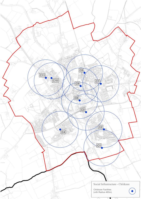
1. Policy Context ..................................................................................................................................... 3

   1.1 Methodology................................................................................................................................. 4

2. Audit Parameters and Community Profile ........................................................................................ 5

   2.1 Demographic Profile ..................................................................................................................... 6

   2.2 Household Composition and Family Cycle .................................................................................... 7

   2.3 Accommodation and Home Ownership........................................................................................ 7

   2.4 Mobility ......................................................................................................................................... 7

   2.5 Employment and Professional Qualifications ............................................................................... 8

   2.6 Health and Deprivation ................................................................................................................. 8

   2.7 General Employment Profile ....................................................................................................... 10

3. Community Profile – Existing Infrastructure ................................................................................... 13

4. Education and Training .................................................................................................................... 13

   4.1 Primary Schools – depicted by purple dots ................................................................................ 15

   4.2 Post Primary Schools – depicted by blue dots ............................................................................ 16

   4.3 Further Education and Training Facilities – depicted by red dots .............................................. 17

   4.4 Demand Analysis ......................................................................................................................... 18

5. Childcare ........................................................................................................................................... 18

   5.1 Demand Analysis ......................................................................................................................... 22

6. Health ............................................................................................................................................... 23

   6.1 Demand Analysis ......................................................................................................................... 27

7. Sports and Recreation ...................................................................................................................... 28

   7.1 Sports Facilities and Amenities ................................................................................................... 29

8. Open Space ....................................................................................................................................... 35

   8.1 Demand Analysis ......................................................................................................................... 39

9. Social and Community...................................................................................................................... 40

   9.1 Demand Analysis ......................................................................................................................... 44

10. Faith ................................................................................................................................................ 44

   10.1 Demand Analysis ....................................................................................................................... 46

                                                                                                                                                           1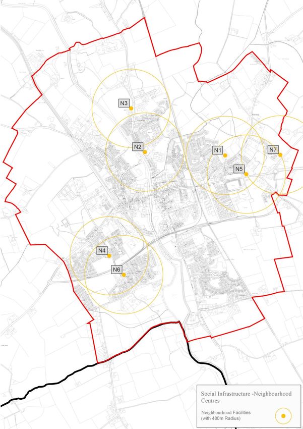
11. Arts and Culture ............................................................................................................................. 46

   11.1 Demand Analysis ....................................................................................................................... 48

12. Other Facilities Including Neighbourhood Centres ....................................................................... 48

   12.1 Demand Analysis ....................................................................................................................... 51

13. Conclusion ...................................................................................................................................... 53

14. Recommendations ......................................................................................................................... 53

   14.1 Education and Training ............................................................................................................. 54

   14.2 Childcare ................................................................................................................................... 55

   14.3 Health ........................................................................................................................................ 55

   14.4 Sports and Recreation ............................................................................................................... 55

   14.5 Connectivity and Linkages......................................................................................................... 56

   14.6 Community Services.................................................................................................................. 56

   14.7 Neighbourhood Centres............................................................................................................ 57

   14.8 Best Practice Measures in the Provision of Community Services and Infrastructure .............. 57

                                                                                                                                                        2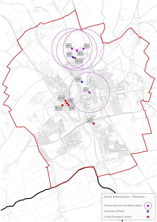
1. Policy Context
The assessment of ‘social infrastructure’ has been considered in the context of the spatial
development objectives for the town of Athy, the parameters of which have been defined in
statutory planning policy documents at a national, regional and county level.

The National Planning Framework (NPF) is the Government’s high-level strategic plan for shaping the
future growth and development of our country out to the year 2040. It recognises the importance of
quality of life and notes that how future development in Ireland is planned will continue to be a
significant determinant of people’s quality of life. National Policy Objective 33 seeks to “prioritise the
provision of new homes at locations that can support sustainable development and at an appropriate
scale of provision relative to location”.

The Regional and Economic Spatial Strategy 2019-2031 (RSES) prepared for the Eastern & Midland
Region seeks to support the implementation of Project Ireland 2040 and the economic policies and
objectives of the Government by providing a long-term strategic planning and economic framework
for the development of the region. Regarding the development of settlements such as Athy, this
document places particular emphasis on town centre renewal and states “keeping a town vibrant
and responsive to the needs of the community is an ongoing challenge and a greater range of
supports need to be put in place to enable successful town centre renewal”. The RSES does not
include any specific Regional Policy Objective (RPO) for Athy but notes that the town is a Level 3
Settlement (a Key Services Centre) in the overall retail hierarchy of the region. The RSES further
notes Athy’s built and natural heritage, including its town walls (remains of) and its location on the
Barrow Blueway.

There are a number of regional policy objectives (RPOs) within the RSES which support the provision
of and access to social infrastructure, including RPO 9.13, which seeks to ensure that new social
infrastructure facilities are accessible and inclusive for a range of users. RPO 9.19 states that the
Eastern and Midland Regional Assembly (EMRA) shall work collaboratively with stakeholders
including the wide range of service providers through the Local Economic and Community Plans
(LECPs) to provide an effective strategy for social infrastructure needs.

The importance of Athy at a county level is emphasised in Variation 1 of the Kildare County Council
Development Plan 2017-2023, where Athy is designated a ‘Self-Sustaining Growth Town’ where its
function is to provide a moderate level of jobs and services, which adequately caters for the people

                                                                                                         3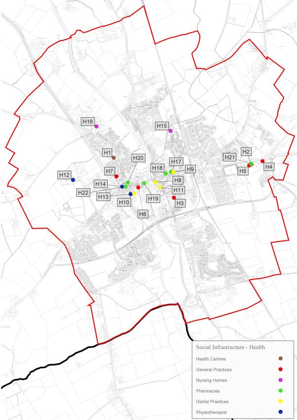
of its service catchment, has good transport links and a capacity for continued commensurate
growth. Under the Core Strategy of the County Kildare Development Plan 2017 – 2023 (CDP) Athy
has been allocated 4.8% of the county’s overall housing growth. Applying this figure to the Athy LAP
translates into a requirement for 771 additional units to be built over the life of the Plan to 20271.
Using the unit occupancy rate of 2.8 persons per household, as provided for in the CDP, the
population of Athy is forecast to increase by 2,160 persons by the end of the Local Area Plan period.
These forecasts result in a population target of 11,837 and a dwelling target of 5,052 units by 2027.

1.1 Methodology
The Social Infrastructure Audit (SIA) was conducted using desktop research and surveys in the field,
as well as incorporating data previously logged and mapped by Kildare County Council. The SIA
assessment comprises 3 parts; An Assessment of the Existing Situation and Infrastructure Provision;
A Future Demand Analysis; and Social Infrastructure Recommendations.

    1. Existing Infrastructure Provision
         The ‘baseline’ assessment was derived from a desktop-based examination of available
         information and use of digital mapping techniques to identify spatial relationships between
         community infrastructure and population catchment in conjunction with several site visits
         for verification purposes. This assessment comprised of the identification and cataloguing of
         existing community infrastructure features (including where relevant, their capacity) under a
         number of predefined themes such as: Education/Training, Childcare, Health,
         Sports/Recreation and Open Space, Social/Community Services, Arts and Culture, Faith, and
         other features.
    2. Future Demands Analysis
         Consideration of existing infrastructure provision relative to the existing and planned
         population and best practice provision.
    3. Recommendations
         Recommendations for future social infrastructure provision which can be taken into
         consideration by the Planning Authority in the preparation of the Local Area Plan, and, in the
         assessment of other social and community programmes.

1
 This figure only includes projected population growth on lands zoned for town centre and new residential uses. It does
not include any increases in population on existing residential/infill lands.

                                                                                                                          4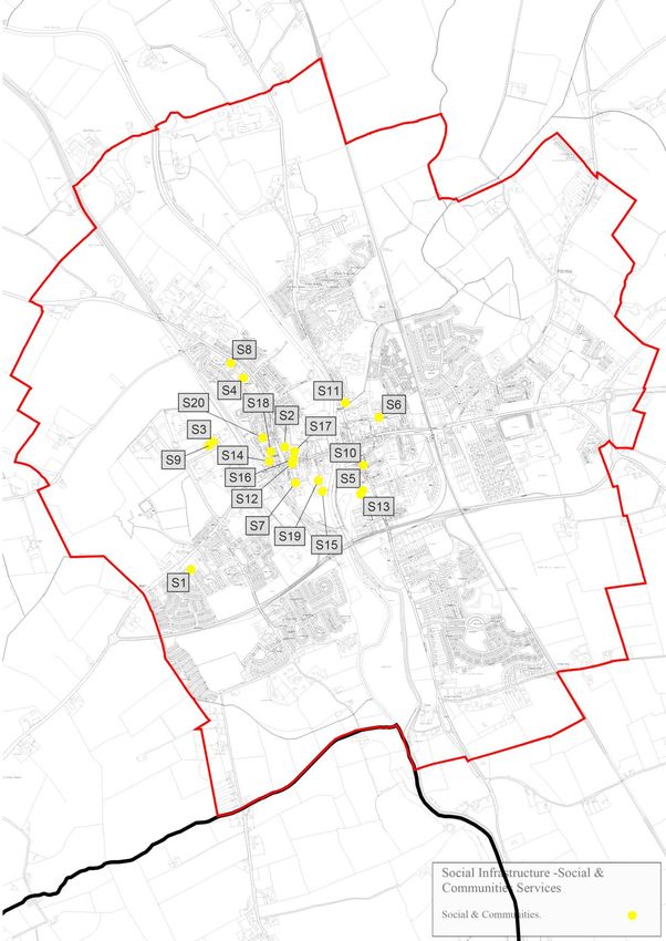
2. Audit Parameters and Community Profile
The function of a Social Infrastructure Audit (SIA) is to examine and analyse the availability and
capacity of existing social infrastructure facilities, and to determine future requirements, and make
recommendations based on anticipated settlement growth. The report is a statement of the
outcome of the SIA.

The Social Infrastructure Audit was prepared by Kildare County Council (KCC) for the purposes of
informing the content and policy objectives of the Athy Local Area Plan 2021-2027.

Social Infrastructure relates to the provision of services and facilities which are essential for health,
well-being and social development of a town or community/neighbourhood. Social infrastructure
facilities include education, health services such as schools, surgeries and community specific
services as well as areas which can offer active sports and passive recreational activities. In addition,
to the actual activity and function, social infrastructure facilities can provide an invisible platform of
community and social interaction which some residents may rely upon for personal well-being. The
provision of the requisite levels of social infrastructure within Athy is therefore vital to support the
planned residential base in both physical facilities and social engagement.

The extent of the study area is shown in Figure 1 (overleaf) which represents the Legal Town
boundary of Athy which defined the boundaries of Athy Town Council. Although this was abolished
by the Local Government Reform Act 2014 it will be used for the purposes of this audit to allow for
the formation of historic comparisons and trends, and to enable the immediate hinterland of the
built-up area of the town to also be surveyed.

                                                                                                             5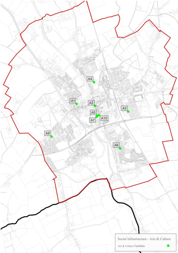
Figure 1: The Study Area – Legal Town Boundary of Athy

Source: www.census.cso.ie/sapmap/

2.1 Demographic Profile
Census 2016 recorded a population of 9,847 persons in the defined Legal Town of Athy which
represents a 2.6% (260 person) increase in the numbers recorded by Census 2011 (9,587 persons).
This represents 4.4% of the county population of 222,504 in 2016. According to Census 2016, the 0-
19 age cohort makes up 32.3% of the population, which is higher than the national proportion of
27.5%, while the 20-64 age cohort is also slightly lower at 56.6% when compared to the national
figure of 59.1%. However, there is a lower proportion of the population aged 65+ years with 11.1%
compared to 13.4% nationally.

Table 1: Population Profile
 Age Group                    Population        % of Total Population Athy   % at National Level
 0-4                          833               8.5%                         7.0%
 5-12                         1,435             14.6%                        11.5%
 13-19                        906               9.2%                         9.0%
 20-64                        5,575             56.6%                        59.1%
 65+                          1,098             11.1%                        13.4%

                                                                                                     6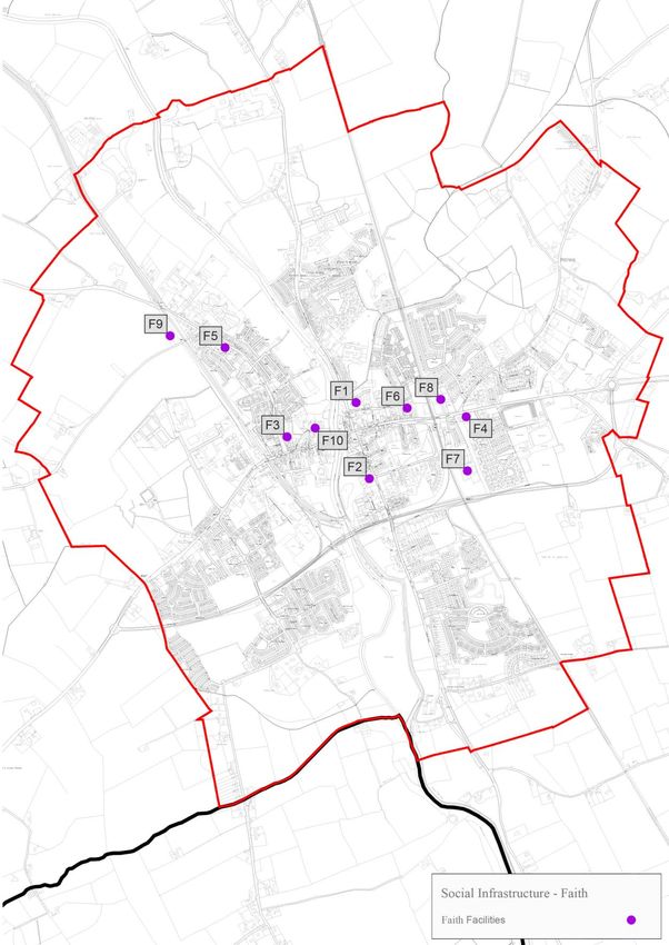
2.2 Household Composition and Family Cycle
Within the study area 3,709 families are recorded. The largest family type consisted of households
comprising of four persons (25% of all families), followed by three persons (20%), two persons (19%),
five persons (15%), and those with one person (11%).

2.3 Accommodation and Home Ownership
Census 2016 recorded that the House/Bungalow is by far the largest accommodation type,
accommodating 86.6% of the population with 11.4% comprising apartment living. The level of home
ownership (outright ownership) and ownership with mortgage at 58% in Athy is notably lower than
the national average at 67.6%. The rental sector also deviates from the national average, particularly
the level of social housing (rented from a local authority or voluntary body) which at 15.4% of
households far exceeds the national average of 9.4%. It is noted that in 2016, Athy had a similar
vacancy percentage (12.5%) to the State (12.3%), though this has diminished greatly in the
intervening period (refer to Chapter 4 Homes and Communities of the Local Area Plan).

2.4 Mobility
Car ownership within households is lower in Athy than the national average with 21.3% of
households recording no car ownership compared to 15% for the State. However, it is noted 13.8%
of the population aged 5 years and over commute 1 hour or over, which is significantly more than
the state percentage of 8.3%. This is likely to be associated with travel time to/from Dublin City or
the surrounding metropolitan hinterland.

17% of workers commute to their workplace using sustainable means, including walking, cycling and
public transport (bus or the train). However, it is noted the vast majority use private transportation
means including car driver (63%), car passenger (4%), van (7%) and motorcycle (1%). 2016 Census
recorded only a very small proportion of the working population worked from home at 2%. It is
considered that such a pattern may have changed with the advent of the Covid-19 pandemic and
subsequent changes to work practices. The outcome of such a shift in work patterns will only
become clear over the longer term.

41% of students commute to school or college using sustainable means, including walking, cycling
and public transport either by bus or train. However, it is noted the majority at 48% commute to
school or college as a car passenger.

                                                                                                         7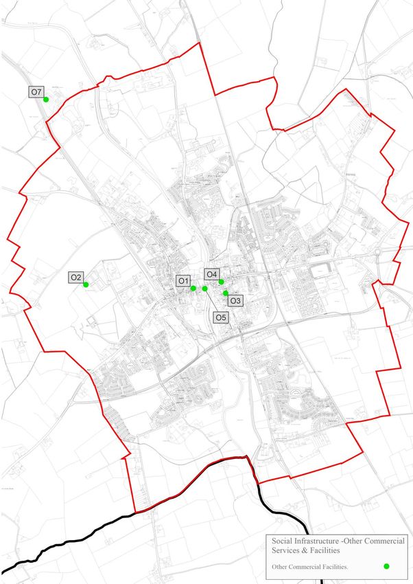
2.5 Employment and Professional Qualifications
The largest workforce group are classified as ‘all others gainfully occupied and unknown’ (29%)
followed by those employed in the Managerial and Technical Sector (20%) and then the Non-manual
group (17%). The smallest workforce group apart from farmers and agricultural workers are the
professional workers group (3%) and unskilled group (4%) with the non-manual and semi-skilled
groups accounting for 32%.

The percentage of pupils dropping out of school after primary school (under 15 years of age) is
similar to that of the State, at 5.9% compared to 6% nationally. However, the level of educational
attainment in Athy is lower than the national average especially for those holding professional
qualifications, including ordinary and higher bachelor’s degrees. The percentage of persons holding
these qualifications in Athy is 12.9%, compared to 18.3% for the State.

2.6 Health and Deprivation
84% of the population of Athy surveyed in Census 2016 described their health in a positive light
either as ‘Good or Very Good’, while 12% of the population of Athy described their health in a
negative light as ‘Fair, Bad or Very Bad’. This compares to 88% of the population of the State
describing their health positively and 9% describing their health negatively.

Athy compares negatively to other neighbouring comparable towns of Carlow and Kildare Town,
Carlow and Newbridge in terms of social deprivation, as indicated by the Pobal HP Deprivation Index.

Figure 2: Key of Pobal HP Deprivation Index

Source: https://maps.pobal.ie/WebApps/DeprivationIndices/index.html

                                                                                                      8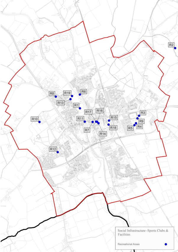
Figure 3: Deprivation Index of Small Area Population Statistics (SAPs) in Athy

Source: https://maps.pobal.ie/WebApps/DeprivationIndices/index.html

This map resource (Figure 3) indicates a high level of deprivation in Athy, with no areas indicated as
being affluent using the key in Figure 2. The majority of the town is designated as disadvantaged,
with the Townlands area in the north west of the town designated as extremely disadvantaged.
When contrasting this to other surrounding towns including Kildare Town, Carlow and Newbridge
mapped (see Figures 4 – 6), it is clear Athy has higher levels of deprivation. It is noted, a small area in
the northwest of the town is highlighted as being ‘extremely disadvantaged’. This area, known as
Athy West Urban is one of the most disadvantaged small areas in the county with 48% of the adult
population residing in this SAP only having received a primary school education.

                                                                                                         9
Figure 4: Deprivation Index of SAPs in Kildare Town Figure 5: Deprivation Index of SAPs in Carlow Town
Figure 6: Deprivation Index of SAP’s in Newbridge
Source: https://maps.pobal.ie/WebApps/DeprivationIndices/index.html
2.7 General Employment Profile
The Census 2016 results record Athy as an area of low employment. 44% of the population aged 15
years and over were recorded as being at work. This is ten percentage points below the national
average of 54%. The level of persons looking after their home/family and unable to work due to
permanent sickness or disability is quite high at 17%, in comparison to the national average of 12%.
10It is noted that Athy stands out as an area of high unemployment in Co. Kildare and this is illustrated
in Figure 7.
However, it is noted as illustrated in Table 2, the trend of persons joining the live register has been
on a downwards trajectory since the height of the last recession in 2010. As of early Summer 2020
Athy does not appear to be substantially impacted by the current pandemic.
Table 2: Live Register Statistics for Athy (2010 – June 2020)
Persons on Live Register (Number) by Social Welfare Office, Sex, Age
2500 2245 2298 2277 2231
2109 2079
1934
2000
1633
1500 1370
1123 1135
1000
483 480 456 449 429 424
500 336 261 187 161 170
0
Average Average Average Average Average Average Average Average Average Average Average
2010 2011 2012 2013 2014 2015 2016 2017 2018 2019 2020
(until
June)
Under 25 years 25 years and over
Source: https://www.cso.ie/en/statistics/labourmarket/liveregister/
11Figure 7: Map of Unemployment Rates in County Kildare (Census 2016)
Source: Kildare Census 2016 Profile Employment Industry and Occupations, Kildare County Council and All
Ireland Research Observatory (AIRO)
123. Community Profile – Existing Infrastructure
Figure 8: Existing Infrastructure as per Audit (August 2020)
Source: Site Survey (August 2020), Social Infrastructure Portal
An audit of social infrastructure within Athy was undertaken using a series of pre-defined themes
including: Education/Training, Childcare, Health, Sports and Recreation, Social/Community Services,
Arts and Culture, Faith, and other features. For illustrative purposes, the location of all physical
social infrastructure features identified and assessed in the study area are mapped in Figure 8
above.
4. Education and Training
Facilities examined under this category include primary and secondary schools along with facilities
accommodating third-level evening classes and skills development programmes. Within the study
area there are four primary schools, two secondary schools and four further education / training
centres. The location of these facilities is illustrated in Figure 9 with further analysis of each type set
out under the following sections.
13Figure 9: Existing Education and Training Facilities as per Audit (August 2020)
Source: Site Survey (August 2020), Social Infrastructure Portal
144.1 Primary Schools – depicted by purple dots
Table 3: Table of Primary Schools as per Audit (August 2020)
Primary Schools (Note: these details are per the Academic year 2019/2020)
Map Name of No. enrolled Capacity Available places
Ref School
E1 Scoil Mhichil 625 Approximately 20 spaces School plans to build
Naofa available but in the Junior stream 28 new classrooms
of the School (replacing prefabs
etc.) and will provide
1 extra classroom
overall.
E2 Scoil 622 At capacity 0
Phadraig
Naofa
E3 Athy Model 97 104 9 (No plans to
School expand)
E4 Gaelscoil Áth 195 208 13
Í,
Direct consultation with each school confirmed that the primary school infrastructure can
accommodate 1,576 children. However, there are 1,539 pupils enrolled in the four primary schools
for the 2019/20 academic year. One of the four schools is operating at capacity, while the other
three are operating at over 90% capacity.
Census 2016 indicates that within the study boundary there are 1,435 children of primary school
going age (5 to 12 years inclusive). The number of pupils enrolled in primary schools within Athy is
141 (circa. 9%) above the number of those within the primary school going age bracket (5 to 12
inclusive). This indicates that schools in Athy are serving a wider catchment with a sizable number of
students attending schools from outside the study area.
154.2 Post Primary Schools – depicted by blue dots
Table 4: Table of Secondary Schools as per Audit (August 2020)
Secondary Schools (Note: these details are per the Academic year 2019/2020)
Map Ref Name of School No. enrolled Capacity Available places
E5 Árdscoil na 856 Unknown 150 for the
Trionóide 2019/2020
school year
E6 Athy 440 School operating at over-capacity 0
Community – it has 3 prefabs at the moment
College and will seek 3 more for the
2020/21 academic year. School
has approval for an extension
that will take capacity to 1,000
places - intended to bring this
forward to the planning stage
soon.
The capacity analysis confirms that Post Primary Schools in Athy are oversubscribed, with both sites
operating above their capacity. Whilst previously there was pressure on school spaces at primary
level the changing demographics of the town means that there is now pressure on school spaces at
secondary level. Athy Community College is currently over capacity and has three prefabs and
requires 3 more for the next term. This secondary school has secured funding from the Department
of Education and Skills for an extension to take the capacity to 1,000 students, however, as of August
2020 a planning application for same has not yet been submitted. It is also noted Árdscoil na
Trionóide no longer takes students from outside the catchment of the Athy area and there is a
lottery system to enrol siblings of pupils located outside this catchment.
Census 2016 records that there are 906 teenagers of secondary school going age – i.e. 13 to 19 years
inclusive inside the study area. The number of pupils enrolled in secondary schools within Athy is
1,296. This would indicate that secondary schools in Athy are serving a wider rural catchment with a
significant number of students from outside the study area (30%). This is not uncommon as 46.8% of
students attending post primary schools in Athy are from outside the town and the town has
historically played a major role as a centre for education for the surrounding rural hinterland. There
is a tendency for secondary school pupils to travel further for secondary education. In some
instances, this is due to necessity whilst in other cases personal preference plays a role. It is noted
many pupils in Athy commute to secondary schools in the neighbouring towns of Stradbally, Carlow
and Naas.
164.3 Further Education and Training Facilities – depicted by red dots
Table 5: Further Education and Training Facilities in Athy (August 2020)
Map ref Name of facility Type of Service Address
E7 Athy Further Education Runs various education programmes Carlow Road
and Training Centre including the Adult Basic Education (ABE)
Service, the Back to Education Initiative
(BTEI), Bridging and Foundation Level
courses etc.
E10 Athy Resource Centre Degree in Business Administration and The Manse,
training and development. Woodstock
Street
E11 Athy Adult Learning Currently closed and no prospectus online. Nelson Street,
Centre Bleach
E12 Athy College Various night courses Rathstewart
National Sports College This facility contains gyms and studios and Fortbarrington
caters for specialist fitness training. Road
https://nsc.ie/
(mapped in
Recreation
section as R12)
While Obair (E8) and Turas Nua (E9) are mapped it was concluded these facilities are more involved
with helping individuals with gaining employment than providing further education.
There are four adult / further education facilities in the area with courses available from FETAC Level
3 up to Level 9. Three of these are located within purpose-built facilities and one within an existing
secondary school. Athy Further Education and Training Centre offered 32 accredited courses in the
2019/2020 academic year.
The percentage of pupils dropping out of school after primary school (under 15 years of age) is
similar to that of the State, at 5.9% compared to 6% nationally. However, the level of educational
attainment in Athy is lower than the national average especially for those holding professional
qualifications including ordinary and higher bachelor’s degrees. The percentage of persons holding
these qualifications in Athy is 12.9%, in comparison to the national average (18.3%).
174.4 Demand Analysis
There is no specific population benchmark for the provision of primary or secondary school facilities
in Ireland. Instead, these are determined on an area specific basis by the Department of Education
and Skills (DoES) having regard to available school capacity, demographic projections, an analysis of
child benefit records, and local GIS travel pattern modelling.
The DoES approach includes a general standard that for every 1,000 dwellings in an area, circa 12%
of the population will require primary school places and 8.5% will require post primary school places.
In Athy 14.6% of the population within the study area are eligible for primary school places
compared to 11.5% nationally. Furthermore, it should be noted that primary schools within the town
are currently catering for 14.9% which indicates that they are serving areas outside of the town.
The demand for secondary school places within the town appears to be above DoES guidance with
the proportion of secondary school going age (13-19) at 9.2%, which is also slightly higher when
compared to the national proportion of 9%. The figure of 9.2% in Athy is somewhat misleading as
the demand for secondary school places in Athy is considerably higher with 1,296 enrolled for the
2019/20 academic year. This represents 13% of the population in the study area which is over the
8.5% figure indicated by the DoES.
Significant pressures are coming on post primary schools due to demand from outside of the study
area with some schools already over capacity. It is anticipated the large proposed extension to the
Athy College would provide for an additional capacity for 560 pupils. Whilst this would relieve some
of the existing pressure on post primary schools, the level of residential development envisaged for
the plan period will add to the demand for school places within the town.
5. Childcare
Childcare infrastructure is well distributed spatially in Athy, with twelve facilities spread throughout
the area and are pre-dominantly located close to or within existing residential developments. Figure
10 illustrates the location of each childcare facility in Athy as noted by Tusla, Pobail or Kildare County
Childcare Committee. As of the end of January 2020 there were 12 childcare facilities surveyed in the
Athy area of which two facilities are outside the study area. The capacity audit of each is set out in
Table 6.
18Figure 10: Location of Childcare Facilities in Athy
Source: Site Survey (August 2020), Social Infrastructure Portal
19Table 6: Capacity of Childcare Facilities
Map Name of Type of No. Capacity Available places Address
Ref facility Service enrolled
C1 Manleys, Full day 45 45 0 Ardreigh
Ardreigh
Montessori
and
Childcare
Centre
C2 Shining Stars Full day 80 80 in each Morning session Coneyboro
Academy session full - No spaces.
Afternoon session
some spaces
approx. 20 but
would need to
increase staff.
C3 Aughraboura Sessional 9 11 2 Aughrabour
Pre-School a
C4 Creative Kids Sessional 81 81 0 Unit 4,
and Full Ardrew
day Square,
Dunbrínn
C5 Fun Times Sessional 10 10 0 Scrouthea,
(Outside of Goulyduff
LAP area)
C6 Shining Stars N/A 65 65 Currently adding Church Road
Homework another room on
Club to the Homework
Club which will
provide 17 more
spaces. The
facility can use
the room for
ECCE class in
morning and
afterschool in the
evening.
C7 Tir na Nóg Full day 100 120 20 Model
Early Years Court,
Care and
20Educational Geraldine
Centre Road
Limited
C8 Rainbow Kids Sessional No No answer Provide the Free 18
Community answer during Preschool Year, Clonmullion
Playschool during survey Subvention and Estate,
survey Full Paying Clonmullin
Children.
Open 9am - 12pm
Monday to Friday
for 38 weeks.
Children are aged
3-5yrs.
C9 Little Angels Sessional 10 11 Offers ECCE (Free Mount Saint
Childcare Preschool Year) Mary's, Athy
and CCS
Subvention
funded scheme
and is open 9am -
1pm, Monday to
Friday
C10 Happy Days Sessional 57 60 3 CDP
Community Woodstock
Childcare Street
C11 Tiny Tots Sessional 32 33 1 Flinter’s
Preschool Estate
Community
Building,
Flinter’s
Close.
C12 Just for Kids Full day 35 37 2 Castledermo
Creche and t Road
Montessori
(Outside of
LAP area)
21Figures obtained from the facilities which responded to the survey show that 479 children were
enrolled for the 2019/20 year. Within the Athy area facilities can cater for up to 506 children, leaving
27 places available in the facilities surveyed.
Overall, childcare facilities are operating at 94.7% capacity within the facilities surveyed in Athy.
However, it should be noted that Shining Stars Homework Club indicates they could have an
additional 17 before and after school places, but this is dependent on recruiting additional staff. It
should also be noted that no information was able to be obtained for Rainbow Kids Community
Playschool and other small scale facilities with 3 children or less not being required to register with
Tusla, and therefore could not be surveyed due to the informal arrangement of these facilities.
Census 2016 shows that 833 children are eligible for childcare (under school going age i.e. 0-4 years
inclusive.) This would indicate approximately 57.5% of children eligible for childcare in Athy avail of
such services.
This audit revealed that 4 of the surveyed facilities noted are at capacity. Responses from a variety
of these facilities confirmed they also have long waiting lists. In total there are four full-time services
in Athy that can accommodate up to 326 children which are currently accommodating 306 children
with only 20 places available. There are six sessional services (generally 3.5 hours per day 9:00am to
12:30 for children aged between 2 and 6 years) in the area with a total capacity for 261 children.
Currently, 254 are enrolled indicating that there are only 7 places available.
A study carried out in 2018 by the County Kildare Childcare Committee entitled ‘Needs Analysis of
Early Years Childcare in County Kildare’ found that services for children under the age of 2 were
inadequate in Athy with parents relying on relatives and childminders. According to Census 2016
there were 475 children in this category.
5.1 Demand Analysis
Appendix 2 of the Childcare Guidelines for Planning Authorities (2001) establishes an indicative
standard of one childcare facility per 75 dwellings in new housing areas. One facility providing a
minimum of 20 childcare places is therefore considered to represent a reasonable target. The
guidance acknowledges that other case specific assumptions may lead to an increase or decrease in
this requirement.
22Whilst the provision of childcare facilities must be spatially considered in the context of existing
levels of service, an additional 206 places 2are anticipated to be required in Athy over the plan
period, having regard to the 771 additional residential units projected to be developed in Athy by
2027.
To comply with the Childcare Guidelines for Planning Authorities, the study area therefore requires
the provision of 10+ facilities with capacity for 20 children each over the period to 2027. Each
existing and new childcare facility (or capacity equivalent) is not restricted to 20 children each and
such provision, for example, could be in the form of an additional 5 facilities with capacity for 42
childcare spaces each. As of August 2020, there are no extant permissions for new childcare facilities
in the town and therefore having regard to the issues around capacity highlighted overleaf all
proposals for new housing developments will be required to address childcare provision.
In addition, it is recommended that an objective is included in the LAP where future residential
developments must justify how childcare provision has been met (i.e. existing capacity) in instances
where childcare facilities are omitted from a scheme. With respect to childcare, the lead agent for
delivery in this regard is the developer.
6. Health
This section focuses on existing health facilities including GPs, health centres, dentists, pharmacy
care and other related facilities.
A total of 27 health facilities were identified in the town comprising 1 Primary Care Centre, 1 Health
Centre, 5 General Practitioners (GPs), 4 Dentist Practices, 4 Physiotherapists, 2 Nursing Homes, 4
Specialist Services and 6 Pharmacies. Within the health facilities identified, there are a total of 13
doctors, 2 Psychiatrists, 4 dentists, 3 physios and 14 nurses (excluding nursing homes and specialist
services).
The location of health facilities is dispersed throughout the town although there are obvious
indications of clustering within the town centre. The locations of these facilities are illustrated in
Figure 11.
2
Appendix 2 of the Childcare Guidelines for Planning Authorities (2001) establishes an indicative standard of
one childcare facility per 75 dwellings in new housing areas. 771 additional dwellings are envisaged over the
lifetime of this LAP. Therefore 206 new childcare places are envisaged.
23Figure 11: Location of Healthcare Facilities in Athy
Source: Site Survey (August 2020), Social Infrastructure Portal and https://www.hse.ie/eng/services/maps/
24An audit of these facilities including their neighbourhood location, services available, and the land
use zoning objectives relative to their location is set out in Tables 7 – 12.
Table 7: Health Centres in Athy
Health Centres
Map Name Description of services / No. of doctors Address
Ref
H1 Athy Health Centre Centre deals with mental health 7 Woodstock St, Townparks
services in the Athy area. There are 2
Consultant Psychiatrists and 3
Registrars.
H2 Athy Primary Care General Practitioners surgery, HSE and Dublin Road
Centre Tusla facilities comprising consulting
rooms, waiting areas, meeting rooms,
offices, ancillary accommodation,
Pharmacy Unit and clinical rooms. This
HSE Facility has 4 community nurses.
Table 8: Doctor Surgeries / GP Practices in Athy
Doctor Surgery / GP
Map Ref Name Description of services / No. of doctors Address
H3 Athy Lodge Medical General Practice - 2 doctors, 3 practice Athy Lodge
nurses
H4 The Park Clinic General Practice - 4 doctors, 1 practice Gallowshill
nurse
H5 Barrowview Medical General Practice - 4 doctors, 4 nurses Athy Primary
Practice Care Centre,
Dublin Road
H6 Dr A.J. Reeves General Practice - 3 doctors Convent Lane
H7 Dr Padraic Farrell General Practice - 1 doctor 89 Woodstock
Street
Table 9: Dentists in Athy
Dentists
Map Ref Name No. of Dentists Address
H8 The Dental Studio Athy 1 8 Emily Square
H9 Athy Dental Practice 1 64 Leinster Street
H10 Richenda Bailey Dentist 1 Green Alley, Bleach
25H11 Loreto Dental Surgery 1 13 Emily Square
Table 10: Physiotherapists in Athy
Physiotherapists
Map Ref Name Description of services Address
H12 Harrigan Physiotherapy Physiotherapy, pilates and Athy Business
and Sports Injury Clinic sports injury clinic Campus, Unit 1 Block
C, Kilkenny Road
H13 Athy Physiotherapy and Physiotherapy, pilates and 8 Riverdale
Sports Injury Clinic sports injury Clinic
H14 RW Sports Injury Physiotherapy and pilates K Leisure Athy,
Greenhills
Not kphysio Physiotherapy, sports injury Hillfarm,
mapped clinic, pilates, massage and Narraghmore
shock therapy (outside the study
area)
Table 11: Nursing Homes in Athy
Nursing Home
Map Ref Name Description of services Address
H15 Cloverlodge Nursing 60 bed nursing home which also Moneen Lane
Home caters for respite care and
dementia care
H16 St. Vincent's Hospital Care of the elderly facility with a Woodstock Street,
maximum capacity of 104 Townparks
patients
Table 12: Pharmacies in Athy
Nursing Home
Map Ref Name Description of services Address
H17 McCauley Pharmacy Pharmacy 59 Leinster Street
H18 Madden’s Pharmacy Pharmacy 51 Leinster Street
H19 Moore’s Pharmacy Pharmacy 6 Duke Street
26H20 McHugh’s Allcare Pharmacy 39 Duke Street
Pharmacy
H21 McCauley Pharmacy Pharmacy Athy Primary Care
Centre
H22 A and A Pharmacy Pharmacy 21 Lower William
Street, Bleach
Table 13: Specialist Services in Athy
Specialist services
Map Ref Name Description of services Address
Not Cuan Mhuire CTR A 117 bed alcohol addiction Cuan Mhuire
mapped treatment facility and a 22 bed
unit for those in recovery from
Drug addiction.
Not Athy Counselling and Counselling and psychotherapy 27 Sunnyside Lawns,
mapped Psychotherapy treatments Ardrew
Not Athy Counselling and Counselling, hypnotherapy and 8 Leinster Court,
mapped Acupuncture Clinic psychotherapy treatments Kirwan’s Lane
Not Friends of Cuan Mhuire Counselling for addiction 21 Lower William St,
mapped Bleach
Source: HSE services and desktop survey, July 2020
6.1 Demand Analysis
It is noted 12% of the population of Athy described their health in a negative light as ‘Fair, Bad or
Very Bad’. This compares to 9% of the population of the State describing their health negatively.
There are no national standards for health provision in Ireland either relating to the provision of
primary care centres or the number of doctors in an area. However, the HSE states that a typical
primary care centre can serve a population of between 10,000-20,000 people, subject to appropriate
resourcing. It is therefore concluded Athy is well served in this regard.
In 2017 the Irish Medical Times noted that Ireland had on average 2.7 doctors per 1,000 population
in comparison with the Organisation for Economic Co-operation and Development (OECD) average
of 3.3 doctors per 1,000. It is assumed that these figures relate to all registered doctors in the
country. A more relevant figure for Athy (excluding hospital services which serve the wider region) is
a standard specifically relating to family physicians. In this regard, the Graduate Medical Education
27National Advisory Committee (GMENAC) suggests a standard of 25.2 physicians to 100,000
population (or 0.25 per 1,000 population).
The current doctor to population ratio in Athy (excluding hospital services) is 1.4 per 1,000
population with 14 doctors practicing from 26 different facilities which is 6 times above the
recommendations of GMENAC. However, should the population grow by the anticipated 2,160
persons by the end of the Plan period in 2027, the ratio of existing doctors per population will fall to
1.2 per 1,000 population which is still almost five times higher than the recommended standard.
Assuming no increase or decrease in doctor numbers during that period this indicates that provision
in Athy would appear to be well-catered for. There is also a high level of community nurses in this
location. However, it must be noted the health services in Athy serve a large rural hinterland outside
of the scope of this study.
In relation to care for the elderly, there are 164 bed spaces across two nursing home facilities. This
would cater for 14.9% of those aged 65 and over (1,098) as outlined in the 2016 census. It should be
noted that Cloverlodge Nursing home is privately run, and St. Vincent's Hospital is run by the HSE.
Both care homes are likely to have a catchment which extends far beyond the Local Area Plan
boundary or study area. Athy is also well-served by a high proportion of mental health services and
rehabilitation centres and there are no national standards for such provisions.
The HSE is monitoring the demand for and provision of health services in Athy on an ongoing basis
and Kildare County Council will continue to consult and liaise with the HSE in this regard.
7. Sports and Recreation
Sports and recreation infrastructure include parks and playgrounds, dedicated public open space and
amenity areas, sports centres, and formal club facilities. Overall, there are 28.7 hectares of land
within the study area which provides for sports and recreational related activities. This open space
provision is considered further under the subsequent headings which provide a breakdown as to the
type of open space they constitute and the purpose that they serve.
28Figure 12: Location of Sports and Recreation Open Spaces in Athy
Source: Site Survey (August 2020), Social Infrastructure Portal
7.1 Sports Facilities and Amenities
There are 12 sports clubs in Athy with sports facilities of various descriptions. Several clubs and
facilities are clustered at the following locations (details of the clubs are contained in Table 13):
• On the eastern side of Athy (located off the Dublin Road) there is a large recreation area
known as the Showgrounds which contains:
o Athy GAA club – This club has 2 full sized flood lit pitches with a club house
containing a multipurpose hall and bar.
o Athy RFC – This club contains 2 floodlit pitches and 2 unlit training pitches,
badminton courts and a clubhouse.
o Athy Town FC – This club contains 1 floodlit pitch, 1 unlit pitch, 3 small all-weather
pitches and a clubhouse.
o Athy Tennis Club – This club contains 6 all-weather tennis courts and a clubhouse
29• The Arch – This is a community centre located on the western side of Athy and its hall is
home to a number of sports clubs including indoor bowls, athletics, soccer groups,
junior/senior karate, Irish dancing classes and feis, fitness classes and Athy Boxing Club.
• K-Leisure Athy – This leisure centre contains a 25 metre swimming pool, an area for fitness
classes, gyms, sauna and steam rooms and a multi-purpose all-weather pitch.
Other amenities include 2 playgrounds, a skate park and the two significant parks of People’s Park
(Local Park3) and Woodstock Park (Neighbourhood Park4).
Overall, there are circa 28.7 hectares of sports area within the study area including the following
categories of Neighbourhood Park, Local Park, Greenways, Sports Pitches and Playgrounds.
Approximately 48% of this area (13.7 ha) is made up of sports pitches.
The location of clubs is mapped in Figure 13, and it is noted while there are a good variety of clubs,
the western part of the town has fewer facilities. There are also other significant facilities which are
outside the study area that also serve the population in the town but are not shown on Figure 13.
These facilities include Athy Golf Club (Geraldine Road) and Burtown House and Gardens.
3
Small area of parkland (>2 ha minimum) located within 0.4km of target population and managed for passive
recreation only.
4
Large area of parkland (>16 ha minimum) located within 0.8km of target population and managed as a public
park to facilitate both passive and active recreation.
30Figure 13: Location of Sports and Recreation Facilities in Athy
Source: Site Survey (August 2020), Social Infrastructure Portal (note sports clubs, facilities and parks
have been annotated on the above map)
31Table 14: Description of Clubs and Sporting Facilities in Athy
Sports and Recreation
Sports Grounds/Clubs (indoor and outdoor facilities)/ leisure facilities
Map Ref Name Description of facilities Address
R1 K-Leisure Athy 25m swimming pool, area for Barrack Lane, Green Hills
fitness classes, gym, sauna
and steam rooms and
astroturf pitches
R2 Athy Golf Club 18-hole golf course with Geraldine Road, Geraldine (not
clubhouse mapped as outside of study area)
R3 Athy GAA club 2 full sized pitches with Geraldine Park
floodlights and club house
which includes a
multipurpose hall and a
newly refurbished bar area
R4 Athy RFC Number of pitches and The Showgrounds, Dublin Road
training pitches, 3 small
astroturf pitches, badminton
courts and clubhouse
R5 Athy Tennis 6 tennis courts and clubhouse The Showgrounds, Dublin Road
Club
R6 Athy Rowing Lease a boat house facility Upper Saint Joseph’s Terrace,
and Canoeing beside River Barrow Rathstewart
Club
R7 Athy Wheelers Based in premises on Emily Emily Square
Cycling Club Square
R8 St. Michael's Gym and training facilities Flinter’s Place, Townparks
Boxing Club
R9 Athy Town FC Clubhouse, indoor astroturf Aldridge Park Athy
pitch shares pitch facilities
with Athy RFC
R10 Athy Kenpo Based in an industrial unit Athy Business Campus, Kilkenny
Karate Club Road, Woodstock South
R11 Athy and This group is currently based The Heritage Centre,
District Anglers in the Marina - the inlet of Emily Square
Club water linked to the River
Barrow and manages access
to it. It is noted that they do
not own the property.
32R12 National Sports This facility contains gyms Fortbarrington Road
College and studios and caters for https://nsc.ie/
specialist fitness training.
R13 Castle Park Very limited facilities Barrack Lane, Rathstewart
Playground
R14 Athy Skate Park Small concrete facility Off Meeting Lane
R15 People’s Park Swings, climbing frames, see-
Playground saws, monkey bars and adult
gym equipment.
R16 and Athy Triathlon No facilities Various
R17 Club http://www.athytriathlonclub.com/
R18 People’s Park Park containing a playground Church Road
and outdoor gym equipment.
R19 Castle Park Park containing a playground, Barrack Lane, Rathstewart
a small astroturf pitch and
Woodstock Castle
Not Athy Chess Club Based in Athy Public library Athy Library, Convent Lane
mapped
Not Athy Indoor Based in the Church of Barrow Hall Parish Centre
mapped Bowling Club Ireland parish centre
Source: Site Survey (August 2020), Social Infrastructure Portal
There are no relevant standards in Ireland for sports facilities. Therefore, consideration is given to
comparative recommendations and specifically, ‘Fields in Trust (FIT)’ recommendations which in the
UK, has set out benchmark guidance for the provision of amenity and open space use in urban
planning and design. The recommendations of ‘FIT’ go beyond the established ‘six-acre standard’ (six
acres or 2.4 hectares (ha) per 1,000 population) and now provides quantitative guidance in relation
to other open space typologies.
The ‘FIT’ benchmark guidance recommends that 1.6 ha of outdoor sports area should be provided
per 1,000 population and that outdoor sports should be located within 1.2 km of all dwellings in
major residential areas. Other ‘FIT’ benchmark guidance recommendations for ‘formal outdoor
space’ which are relevant to this study are set out in Table 14.
33Table 15: Fields in Trust (FIT) Benchmark Guidance for Different Recreational Facilities
Type Hectares per 1,000 Walking distance
population from dwelling
Playing Pitches 1.2 1,200m
All outdoor sports 1.6 1,200m
Equipped / Designated play areas:
- Local Areas for Play – aimed at very young 0.25 100m
children
- Local Equipped Areas of Play – aimed at 0.25 400m
children who can go out to play
independently
- Neighbourhood Equipped Areas for Play 0.25 1,000m
aimed at older children
- Multi Use Games Areas (MUGAs) and 0.3 700m
skateboard parks etc
Source: Fields in Trust (FIT)
Within the study area there are 19 ha of outdoor sports facilities (Planning Pitches: 18.46ha and
Playgrounds/skatepark: 0.53 ha). Based on the Census 2016 population, the current outdoor sports
area provision is 1.96 ha per 1,000 population. Accordingly, it would appear using FIT standards
there is more than adequate outdoor sports ‘area’ in the town to serve the existing population in the
context of these guidance recommendations.
However, should the planned population growth (projected to be 11,837 by 2027) be achieved, the
standard of outdoor sports decreases to 1.61 ha per 1,000 population in 2026 and is therefore still
compliant with guidance recommendations. It is also noted that a further c.5 ha of Kildare County
Council lands are proposed to be converted into a future sports training hub on Council owned lands
at Ardrew, in the west of the town.
The provision of two playgrounds and a skatepark (approximately 0.53 ha) within the study area falls
short of the benchmark guidance in terms of quantity, and provision for all age groups. Based on the
2016 census population current playground provision is 0.055 per 1,000 people considerably short of
the 0.25 benchmark. To comply with benchmark standards a further 4.55 ha of playground facilities
should be provided within the study area. However, it is noted the current play area provision is of a
similar level to that provided in neighbouring towns such as Naas.
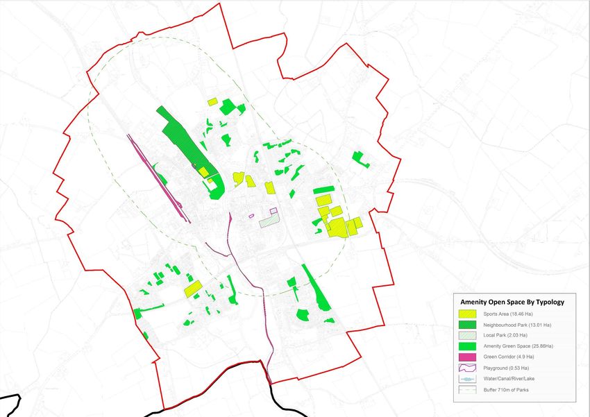
348. Open Space
Open space has been categorised by typology of use which is consistent with the amenity space
typology types employed in the Kildare Open Space Strategy 2011 which is currently being
updated/reviewed with an expected completion date of Q2 2021. These include neighbourhood
parks, local parks, green corridors, natural / semi natural green spaces, and other open spaces such
as amenity green space associated with housing estates. The definition of each is outlined in Table
15. The spatial location and distribution of the open space by typology of use, is illustrated in Figure
13. An audit of open space typology types is also presented in Table 16 including current provision of
each type along with qualitative recommendations.
Table 16: Audit of amenity Open Space by Typology
Name / Typology Definition Amount in Standards & Recommendations
study area
in hectares
(ha)
Neighbourhood Large area of parkland 13.01 ha Should be regular in shape and
Park (>16 ha minimum) contain:
located within 0.8km of - Football pitches up to 6 units
target population and - Tennis Courts up to 10 units
managed as a public - Netball/Basketball Court up to 2
park to facilitate both units
passive and active - Golf Putting Green up to 2 units
recreation. - Children’s Playlots up to 2 units
- Car Parking up to 1 unit
Local Park Small area of parkland 2.03 ha Should be designed for passive
(>2 ha minimum) recreation only and be attractively
located within 0.4km of landscaped with trees and shrubs.
target population and Paths, seats, and litter bins should be
managed for passive adequately provided.
recreation only.
Amenity Green Relatively small areas of 25.85 ha To be of a size and quality to
Space open space associated enhance residential areas.
with individual housing
estates.
Play space for Areas designed to 0.53 ha
children and facilitate children’s play
teenagers usually located within an
existing public park and
35easily accessible from
residential areas.
Green Corridors Linear green spaces such 4.9 ha
as canal and river
corridors.
Natural / semi Areas of undeveloped or 20.6 ha
natural green previously developed
spaces land with habitats such
as woodland or wetland
areas.
Total 67.14 ha
Source: Desktop and GIS analysis and field survey, July 2020
There is one Neighbourhood Park within the study area, which is located north of the town centre
on the western bank of the River Barrow. The Park is mainly used for passive recreation but also
includes a children’s playground, a 5-aside all-weather pitch, a soccer pitch and the ruins of
Woodstock Castle (fenced off). While these uses meet FIT recommendations, this park is marginally
smaller than the 16 hectare area recommended. In this circumstance this is considered acceptable
as there are also 3 ha of open space surrounding K-Leisure immediately south of this park, which
could in the future be incorporated.
The People’s Park off Church Road meets the criteria for a local Park in terms of passive recreation
and size. However, it is also noted this park has facilities for active recreation such as a playground
and adult gym equipment. This park is also served by an extensive carpark.
In addition to the two main parks there are paths along the banks of the River Barrow and the
Barrow Line Canal providing a high-level public amenity. It is noted that the majority of open space
in Athy is provided in the form of green space within residential estates.
Section 14.11.4 Recreation and Amenity of the Kildare Development Plan 2017-2023 (page 331)
states ‘Overall, the Council will seek the provision of open space at a standard of 2.0 ha per 1000
population in accordance with the Kildare Open Space Strategy 2011.’ Therefore 19.35 ha5 of open
space is currently required and a further 4.32 ha6 is required for the period of this LAP. It can be
5
The 2016 census put the population of Athy at 9,677 persons. Therefore, if the 2ha per 1,000 persons Kildare
Open Space Strategy 2011 standard it used, Athy requires 19.35ha of open space.
6
Over the LAP period the population is envisaged to grow by 2,160 persons. Therefore, if the 2ha per 1,000
persons Kildare Open Space Strategy 2011 standard it used, Athy requires an additional 4.32ha of open space.
36observed from Table 16 above that Athy currently exceeds these figures. No Irish standards exist to
further analyse this open space provision, so consideration has been given to the 2015 ‘FIT’ (Fields in
Trust) recommended benchmark guidelines for ‘informal outdoor space’. These guidelines assess the
location and quantity of various open space typologies against recommended standards.
Table 17 indicates Fields in Trust (FIT) benchmark guidelines for open space in the sectors of area
and location.
Table 17: Fields in Trust (FIT) Benchmark Guidance for Open Space
Type Hectares per 1,000 Walking distance from
population dwelling
Parks and Gardens 0.8 710m
Amenity Open Space 0.6 480m
Natural and Semi Natural Open Space 1.8 720m
Playground 0.25 Not defined
Source: Fields in Trust (FIT)
Table 18 presents an evaluation of the existing open space provision in Athy against these
benchmark guidelines.
Table 18: Evaluation of Open Space in Athy against FIT Standards
Typology Existing Typology F.I.T. Existing Future
(defined by the Kildare Area ‘FIT’ definition Standard Provision Provision
Open Space Strategy) (ha) in (ha/1000 in Athy In Athy
Athy pop.) (ha/1000 (ha/1000
pop.) pop.)
Neighbourhood Park 13 ha ‘Parks and 0.8 1.55 1.27
Local Park 2 ha Gardens’
Amenity Green Space 25.85 ha ‘Amenity Open 0.6 2.67 2.18
Space’
Green Corridor 4.9 ha ‘Natural and Semi- 1.8 2.64 2.15
Natural / Semi-Natural 20.6 ha Natural Open
Green Space Space’
Playground 0.53 ha ‘Playground' 0.25 0.055 0.045
Source: Desktop and Field Surveys
37You can also read