Operational report for Rangitāne o Manawatū Settlement Trust - Rangitāne o Manawatu Settlement Trust
←
→
Page content transcription
If your browser does not render page correctly, please read the page content below
Operational report for Rangitāne o Manawatū Settlement Trust
Cover: Manawatu Gorge. Photo: Department of Conservation, Palmerston North

© Copyright New Zealand Department of Conservation

June 2018

Published by:
Department of Conservation Te Papaioea/Manawatu Office
Private Bag 11010, Palmerston North 4442, New Zealand

This publication is produced using paper sourced from well-managed, renewable and legally logged forests.
Operational report for Rangitāne o Manawatū Settlement Trust 2016–2017

Contents
Executive summary                                                                                 5
   Initial work under the Protocol has begun                                                      5
   Work at DOC-managed sites in the Conservation Protocol Area has progressed this year           5
   Other Treaty settlement implementation work is under way                                       6

1. Introduction                                                                                   7
        Acknowledgements                                                                          8

2. The Rangitāne o Manawatū Conservation Protocol                                                 9
   Communication                                                                                 10
      The new Wellington Conservation Management Strategy                                        10
      Pukepuke Lagoon Conservation Area work                                                     11
   Visitor and public information                                                                 11
   Cultural materials                                                                             11
   Marine mammals – process for strandings in the protocol area                                  11
       Update of the Manawatu Operational Plan for Marine Mammal Incidents                       12
   Freshwater fisheries and marginal strips                                                      12
   Sites of significance                                                                         12
   National programmes                                                                           12
   Pest control                                                                                  12
   Business and management planning                                                              13
   Contracting for services                                                                      13
   Concession applications                                                                       13
       Table of active concessions 2016/2017                                                     13

3. DOC-managed sites in the Rangitāne o Manawatū Conservation Protocol Area                      14
   Omarupapako/Round Bush Scenic Reserve (Omarupapako)                                           14
       Pest control                                                                              15
       Revegetation 2016                                                                         15
   Pukepuke Lagoon Conservation Area (Pukepuke)                                                  16
       Pest control                                                                              17
       Concessions                                                                               17
   Rangitikei River mouth coastal reserves and conservation areas                                17
       Weed control and maintenance at Tawhirihoe Scientific Reserve                             18
       Concessions                                                                               18
   Manawatu Gorge Scenic Reserve (the Gorge)                                                     19
       Pest control                                                                              20
       Scheduled track and structure maintenance                                                 20

                                                                                                       3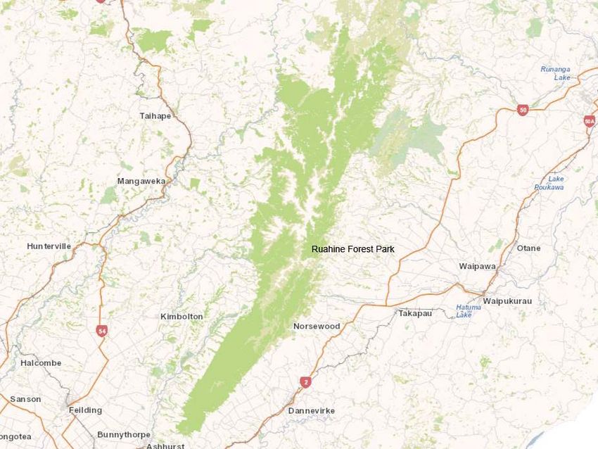
Ruahine Forest Park                                                        20
        Pest control                                                           21
        Scheduled track and structure maintenance                              21
        Partnerships and sponsorship                                           22
    Tararua Forest Park                                                        22
         Scheduled track and structure maintenance                             23

4. Implementing the Treaty settlement                                          24
    Awapuni Conservation Area (Awapuni) boundary redefinition survey           24
    Mārima Peak pest control                                                   25
    DOC and Rangitāne o Manawatū MoU                                           25
    Developing the Pukepuke Lagoon Conservation Area (Pukepuke) Natural
    Heritage Plan                                                              26
         Working in partnership to restore Pukepuke                            26
    Geomorphological assessment of Pukepuke                                    27

Appendix 1: Table of active concessions on public conservation lands (PCL)
  in the Rangitane o Manawatu area of interest                                 28

Bibliography                                                                   37

List of figures
    Figure 1: Rangitāne o Manawatū Conservation Protocol Area                   9
    Figure 2: Omarupapako/Round Bush Scenic Reserve                            14
    Figure 3: Pukepuke Lagoon Conservation Area                                16
    Figure 4: Rangitikei River mouth coastal reserves and conservation areas   18
    Figure 5: Manawatu Gorge Scenic Reserve                                    19
    Figure 6: Ruahine Forest Park                                              21
    Figure 7: Tararua Forest Park                                              23

List of tables
    Table 1: Tracking rates of rats and mice at Omarupapako, 2012–2017.        15
    Table 2: Mustelid box trap-kill records at Omarupapako for 2016/17.        15
    Table 3: Plant species and numbers planted at Omarupapako in 2016.         16
    Table 4: Mustelid box trap-kill records at Pukepuke for 2016/17.           17
    Table 1.1: Active concessions on public conservation lands (PCL) in the
    Rangitāne o Manawatū area of interest.                                     28

4
Operational report for Rangitāne o Manawatū Settlement Trust 2016–2017

Executive summary
This is the first annual operational report for Rangitāne o Manawatū Settlement Trust. It
summarises the work that is being carried out between Rangitāne o Manawatū and the
Department of Conservation in relation to the Rangitāne o Manawatū Conservation Protocol
issued by the Crown on 12 December 2016.

Initial work under the Protocol has begun
Key areas of progress are as follows:
     •    A draft version of the new Wellington Conservation Management Strategy (CMS) for
          2016–2026 is now available, which includes some of the Manawatū-Rangitikei area
          and the Ruahine Forest Park and surrounding areas. The Governance Entity
          submitted to DOC on the new CMS and DOC has provided feedback. We are now
          awaiting the next steps in the process to finalise this.
     •    Work at Pukepuke Lagoon Conservation Area has begun. DOC has also
          commissioned work on a natural heritage plan and a geomorphological survey of the
          area.
     •    Ongoing business planning between DOC and the Governance Entity.
     •    The Operational Plan for Marine Mammal Incidents for the Manawatu District has
          been updated.

Work at DOC-managed sites in the Conservation Protocol Area has
progressed this year
DOC manages six sites in the Conservation Protocol Area on behalf of the Governance Entity:
     •    Omarupapako/Round Bush Scenic Reserve
     •    Pukepuke Lagoon Conservation Area
     •    Rangitikei River mouth coastal reserves and conservation areas
     •    Manawatu Gorge Scenic Reserve
     •    Ruahine Forest Park
     •    Tararua Forest Park.

Progress highlights include:
    •    Pest control continues at Omarupapako/Round Bush Scenic Reserve, and a new pest
         control trapping program has started at Pukepuke Lagoon Conservation Area.
     •    Ongoing weed control at Tawhirihoe Scientific Reserve.
     •    Aerial and ground control operations in Manawatu Gorge Scenic Reserve to control
          mustelid species, as well as possum monitoring. In addition, work is planned for some
          of the tracks and structures that are part of the Manawatu Gorge Walk, which is a
          Gateway Destination.

                                                                                                  5
•   Continued pest control in Ruahine Forest Park, including pest control to protect
             whio/blue duck (Hymenolaimus malacorhynchos), goat (Capra aegagrus
             hircus)/stock control, and old man’s beard (Clematis vitalba) and lodgepole pine
             (Pinus contorta) control and surveillance. Monitoring is also carried out for kiwi in
             winter and short-tailed bats (Mystacina tuberculata) in summer. In addition, work is
             planned for many tracks and structures in the park, many of which are Local
             Treasures or Gateway Destinations.
         •   Ongoing track and hut maintenance in Tararua Forest Park.

    Other Treaty settlement implementation work is under way
    DOC has also progressed extra work in Treaty settlement implementation in relation to the
    Protocol, as agreed with Rangitāne o Manawatū Settlement Trust. DOC has appointed a Treaty
    Implementation Ranger.
    Work achieved for the 2016/2017 year includes:
         •   Completion of a boundary redefinition survey for Awapuni Conservation Area, which
             has been vested in fee simple to Rangitāne o Manawatū due to its cultural
             significance.
         •   An agreement between DOC and the Governance Entity that DOC will grant and
             purchase on behalf of the Governance Entity 150 DOC 200 traps for pest control at
             Mārima Peak, which will increase the Governance Entity’s capacity and will also have
             cultural benefits for its whānau, hapū and iwi.
         •   The establishment of a Memorandum of Understanding between DOC and
             Rangitāne o Manawatū for the development of a conservation management plan for
             the Rangitāne o Manawatū area of interest.
         •   A natural heritage plan for Pukepuke Lagoon Conservation Area was developed by
             Wildlands Consultants Ltd.
         •   Roger Shand (Coastal Systems Ltd) has been commissioned to undertake a
             geomorphological assessment for Pukepuke Lagoon Conservation Area.

6
Operational report for Rangitāne o Manawatū Settlement Trust 2016–2017
1. Introduction
The purpose of this report is to update the Rangitāne o Manawatū Settlement Trust (the
Governance Entity) on the Department of Conservation’s (DOC’s) work related to the
Rangitāne o Manawatū Conservation Protocol (the Conservation Protocol) issued by the
Crown. It sets out:
1. DOC’s approach and responsibilities under the Conservation Protocol in relation to
communication and consultation with the Governance Entity, and business planning;
cultural, historical and natural heritage resources; and active concessions.
2. Activities and progress at specific DOC-managed sites within the Rangitāne o
Manawatū DOC Conservation Protocol Area (Protocol Area), including pest and weed
control, concessions and other activities.
3. Treaty settlement implementation work in 2016/2017 within the Protocol Area.
DOC is the Crown agency responsible for managing and promoting the conservation of New
Zealand’s historic natural heritage on behalf of, and for the benefit of, present and future New
Zealanders.
As part of the Rangitāne o Manawatū Claims Settlement Act 2016, the Crown has issued,
through the Minister of Conservation, a Conservation Protocol. This Protocol sets out a
framework to enable DOC and the Governance Entity to establish a constructive working
relationship that gives effect to section 4 of the Conservation Act 1987.1
Rangitāne o Manawatū statutory areas managed by DOC are: Omarupapako/Round Bush
Scenic Reserve, Pukepuke Lagoon Conservation Area, Tawhirihoe Scientific Reserve,
Manawatu Gorge Scenic Reserve, Ruahine Forest Park and Tararua Forest Park. There are
deeds of recognition between the Rangitāne o Manawatu Settlement Trust and the Minister of
Conservation for these reserves. In addition, there are whenua rāhui over part of Himatangi
Bush Scientific Reserve and Makurerua Swamp Wildlife Management Reserve. Other lands
managed by DOC in the Protocol Area are:
• Tangimoana Dunes Recreation Reserve and Moanaroa Conservation Area at
Tangimoana
• Pohangina
• Manawatu Estuary at Foxton
• Kāpiti Island.
There are two legislated iwi settlements in the Manawatū DOC Operational District that
require implementation, one of which is Rangitāne o Manawatu. In mid-January 2017, a Treaty
Implementation Ranger was appointed to implement and support Treaty settlement work with
the Governance Entity.
1
Conservation Act 1987, section 4: ‘This Act shall so be interpreted and administered as to give effect to the
principles of the Treaty of Waitangi’.
7Acknowledgements
DOC would like to thank:
• Danielle Harris (Chair of Rangitāne o Manawatū Settlement Trust)
• Paul Horton (Environmental Officer, Te Ao Turoa Environmental Centre)
• Jon Proctor (Environmental Advisor, Te Ao Turoa Environmental Centre)
• Nathan Maniapoto (Kia Ora FM)
• Whānau, hapū and iwi of Rangitāne o Manawatū
• The team at Wildlands Consultants Ltd
• Roger Shand from Coastal Systems Ltd.
Heoi anō rā, he mihi miharo ki a koutou katoa a Rangitāne o Manawatū.
8Operational report for Rangitāne o Manawatū Settlement Trust 2016–2017
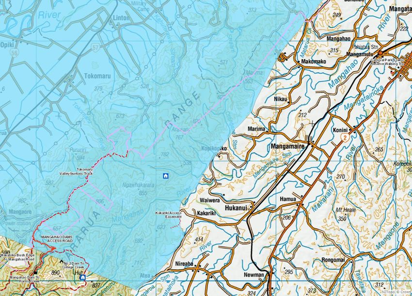
2. The Rangitāne o Manawatū Conservation Protocol
The Conservation Protocol aims to achieve, over time, the conservation policies, actions and
outcomes sought by both DOC and the Governance Entity and sets out a framework for a
constructive working relationship between them. It provides for the Governance Entity to input
meaningfully into certain policy, planning and decision-making processes in DOC’s
management of conservation lands and its fulfilment of statutory responsibilities within the
Conservation Protocol Area (Figure 1).
Figure 1: Rangitāne o Manawatū Conservation Protocol Area
Source: Rangitāne o Manawatū Deed of Settlement.
9Communication
DOC’s primary contacts for the Governance Entity are Danielle Harris, Chief Executive Officer
of the Governance Entity and Paul Horton, Te Ao Turoa Environmental Officer. DOC also has
contact details for the Tanenuiarangi Manawatu Incorporated office in Palmerston North.2
DOC and the Governance Entity meet regularly to discuss reserve management, cultural
redress, and pest control. This year, DOC’s Lower North Island Operations Director Reg
Kemper joined one of these meetings and shared current and future work and potential
opportunities for DOC to support the Governance Entity’s work to grow conservation.
“The Trust and DOC have built up a positive working relationship and are moving towards a
partnership approach in the way they are engaging and working with each for not only the
benefit of the Iwi but in the wider kaitiakitanga of our natural environment. It has been very
good to have a DOC staff member assigned to help develop and grow this partnership and
contribute to the work programme being achieved in the first year,” says Danielle Harris, Chair
of Rangitāne o Manawatū Settlement Trust.
The new Wellington Conservation Management Strategy
A new Wellington Conservation Management Strategy (CMS) (2016–2026) will replace the
current Wellington CMS 1996–2005. The new strategy document outlines changes to the
Wellington CMS region’s boundaries that overlap with those of the protocol. These include:
• some of the Manawatū-Rangitikei area, which was previously covered by the
Whanganui CMS (1997–2008), and
• the Ruahine Forest Park and adjoining land, which was previously covered by the
Hawke’s Bay CMS (1994–2004).
The new Wellington CMS is simpler, more concise and Place-based, bringing it into line with
the other newly reviewed CMSs. It also integrates DOC’s national priorities with local priorities
that have been identified with tangata whenua, the community and others.
The Governance Entity sought DOC’s feedback on its submission on the CMS during their
regular and business planning meetings. Submissions on the draft CMS closed on 4 April 2017
and hearings were held in May. DOC’s responses to the submissions and the revised draft
Wellington CMS were referred to the Wellington Conservation Board (the Board).
As the next steps of the process: 3
1. The Board considers the changes DOC has made in the revised CMS draft in response
to the submissions. The Board may ask DOC to further revise the draft CMS.
2. The draft CMS is sent to the New Zealand Conservation Authority (NZCA) for
approval. The NZCA may also require further changes to the CMS.
3. The draft CMS is referred to the Minister of Conservation for comment.
4. The NZCA approves the CMS and the strategy is notified as operative.
2
Under clauses 2.1.1 and 2.1.3 of the Conservation Protocol, DOC is required to maintain a record of the
Governance Entity’s office holders, and their addresses and contact details; and appoint the Conservation
Partnerships Manager as the primary contact person for the Governance Entity.
3
Process updates are posted at www.doc.govt.nz/get-involved/have-your-say/all-consultations/2016/draft-
wellington-cms-consultation.
10Operational report for Rangitāne o Manawatū Settlement Trust 2016–2017
Pukepuke Lagoon Conservation Area work
DOC coordinated a meeting with Ngā Wairiki Ngāti Apa; Jacobs (independent consultants);
Peter Barber, a local landowner; Horizons Regional Council (Horizons); and Manawatu District
Council (MDC) to discuss the history and work at Pukepuke:
• Te Rūnanga o Ngā Wairiki Ngāti Apa owns Māori land near Lake Kaikokopu, which
is close to Pukepuke.
• Peter Barber and his family have farmed the area for decades; Mr Barber has local
knowledge and has worked with DOC.
• Horizons has contracted Marianne Watson to collect historical data from Pukepuke
to feed into Jacobs’ forthcoming report on catchment water (commissioned earlier by
Horizons).
Visitor and public information
DOC will consult the Governance Entity on the use of information about Rangitāne o
Manawatū values included in information for visitors published by the Department.
DOC will work with Rangitāne o Manawatū to encourage respect for Rangitāne o Manawatū
cultural heritage values, and accuracy in how those values are described, by raising public
awareness of any positive conservation partnerships between Rangitāne o Manawatū and the
Department. These may include publications, presentations and services.
Cultural materials
DOC will facilitate the Governance Entity’s access to cultural materials for propagation and
other activities, taking into consideration the interests of other tangata whenua. DOC may
discuss with the Governance Entity the need for procedures to monitor the levels of use of
cultural materials.
Under current legislation, some form of concession or permit is required for any gathering and
possession of cultural materials from public conservation land. DOC welcomes the opportunity
to find practical ways for Rangitāne o Manawatū to exercise kaitiakitanga on public
conservation land in the Manawatu District.
Marine mammals – process for strandings in the protocol area
All marine mammal species within New Zealand and New Zealand’s fisheries waters are
protected under the Marine Mammals Protection Act 1978. Under the Act, DOC is responsible
for the protection, conservation and management of all marine mammals, including their
disposal, and the health and safety of staff and volunteers under its control.
DOC recognises the opportunity in these circumstances to meet the cultural interests of
Rangitāne o Manawatū and to help gather scientific information. Because the on-site recovery of
bones raises public safety risks, 4 DOC aims to ensure that protocols around marine mammal
strandings are followed. If Rangitāne o Manawatū does not wish to recover the bones or
participate in any other way, the Governance Entity will notify DOC.
4
Such as potential infection from dead and decaying tissue.
11Update of the Manawatu Operational Plan for Marine Mammal Incidents
The Operational Plan for Marine Mammal Incidents for the Manawatu District was recently
updated. This plan sets out the process DOC will follow when there is a marine mammal
stranding in Manawatu. In the event of a stranding where there is overlapping interest, all iwi
will be contacted and the lead iwi will be determined through ‘turnabout’ (an iwi notifies DOC if
it swaps, passes or allocates its ‘lead’ turn to another iwi).
In the plan, the indicative rohe captures the area within the Manawatu Operations District
only. The Marine Mammal Stranding Plan for the Wellington Operations District 5 captures iwi
interests that extend into that district. This plan also notes the indicative rohe that may need to
be updated in the future because of Treaty settlement processes. The plan can also be updated
if other details (eg contact details) change, or if Rangitāne o Manawatū decides it would like to
be contacted for specific strandings (eg of seals). An amended version of the plan will be sent
to the Governance Entity if any details change.
Freshwater fisheries and marginal strips
Freshwater fisheries are managed under two sets of legislation: the Fisheries Act 1983 and 1996
(currently administered by the Ministry for Primary Industries) and the Conservation Act 1987
(administered by DOC). DOC’s functions include the preservation of indigenous freshwater
fisheries and habitats, and DOC welcomes the opportunity to work with Rangitāne o Manawatū
in the conservation, management and research of customary freshwater fisheries and
freshwater fish habitats. DOC will also discuss the management of marginal strips of
significance to Rangitāne o Manawatū with the Governance Entity on an ongoing basis.
Sites of significance
Some sites of significance to Rangitāne o Manawatū are acknowledged in the settlement
legislation. DOC manages some of these sites in accordance with its statutory role to conserve
historic resources in protected areas. DOC also accepts that Rangitāne o Manawatū may
choose non-disclosure to preserve the wāhi tapu nature of certain places.
National programmes
DOC undertakes a number of national programmes to help meet its mandate to conserve the
full range of New Zealand’s ecosystems, maintain or restore the ecological integrity of
managed sites, and ensure the survival of threatened species, particularly those that are most at
risk of extinction. DOC will advise the Governance Entity of any national programmes
operating in the Rangitāne o Manawatū area of interest.
Pest control
One of DOC’s main objectives and functions is to prevent and manage threats to natural,
historic and cultural heritage values from animal and weed pests. This is to be done in a way
that maximises the value from limited resources. Where appropriate, DOC will consider
5
The Rangitāne o Manawatū Conservation Protocol Area includes Department of Conservation Manawatu
and Kapiti Wellington offices.
12Operational report for Rangitāne o Manawatū Settlement Trust 2016–2017
coordinating its pest control programmes with those of the Governance Entity where the
Governance Entity owns adjacent land.
Sites managed by DOC within the Conservation Protocol Area have received various degrees
of pest control in the 2016/17 operating year, this work is discussed later in this report.
Business and management planning
DOC’s annual business planning process determines its conservation work priorities. On 21
February 2017, DOC and the Governance Entity met to discuss business planning for the
2017/18 year. DOC informed the Governance Entity of work at Rangitāne o Manawatū
Statutory Acknowledgement areas and on other DOC-managed lands in the Conservation
Protocol Area.
Contracting for services
Where appropriate, DOC will consider using the Governance Entity as a provider for
professional services including cultural advice and pest management where those services are
necessary to manage conservation resources in the Conservation Protocol Area.
Concession applications
A concession is an official authorisation to operate in an area managed by DOC, and may be in
the form of a lease, licence, permit or easement. Activities that require a concession include
accommodation facilities; water, air or land transport services; commercial education or
instruction activities; guiding; attractions such as bungy jumping; and services such as shops,
tearooms, restaurants, garages or hire services. Concessions are also required for grazing,
baches, telecommunication facilities, filming and beehives. Although DOC occasionally
tenders concession opportunities publicly, most concessions are initiated by an individual or
firm that approaches DOC seeking permission for an activity.
DOC consults the Governance Entity regarding any concession applications or renewals of
applications within the Conservation Protocol Area. This allows the Governance Entity to
indicate whether applications will affect Rangitāne o Manawatū cultural, spiritual and historic
values. Prior to issuing a concession, DOC advises a concessionaire of any impacts on
Rangitāne o Manawatū values and encourages communication between the concessionaire
and the Governance Entity.
Table of active concessions 2016/2017
See the Appendix for a list of active concessions on public conservation land.
In the 2016/2017 year, DOC received 114 concession applications for activities in the
Conservation Protocol Area.
133. DOC-managed sites in the Rangitāne o Manawatū
Conservation Protocol Area
Omarupapako/Round Bush Scenic Reserve (Omarupapako)
Omarupapako ranks as number 52 of New Zealand’s 1,000 ecosystem management units
(EMUs). This reserve covers 51.47 ha and is located north of Foxton between Wiley Road and
State Highway 1 (see Figure 2), with the main access being from Wiley Road. Omarupapako is
one of only a few remnants of coastal swamp forest on the west coast and consists of coastal
forest and wetland vegetation growing on a sand dune and dune slack system. The forest is
dominated by kahikatea (Dacrycarpus dacrydioides), pukatea (Laurelia novae-zelandiae) and
tītoki (Alectryon excelsus), with some tawa (Beilschmiedia tawa) and māhoe (Melicytus
ramiflorus) and various other broadleaved species in the subcanopy, while the swamp is
dominated by harakeke/flax (Phormium tenax), raupō (Typha orientalis) and tī kōuka/cabbage
tree (Cordyline australis), with olearia and coprosma species in drier areas. The swamp also
hosts a population of the threatened swamp greenhood orchid (Pterostylis micromega).
Figure 2: Omarupapako/Round Bush Scenic Reserve
14Operational report for Rangitāne o Manawatū Settlement Trust 2016–2017
Pest control
Both plant and animal pest control has been undertaken at Omarupapako. In the 2016/17
operating year, weed control at Omarupapako focussed on periwinkle (Vinca major), pampas
(Cortaderia spp.), Formosa lily (Lilium formosanum) and tradescantia (Tradescantia
fluminensis).
A successful rat (Rattus spp.) and possum (Trichosurus vulpecula) control regime has also been
carried out at Omarupapako and continues. For rat control, 94 large Philproof bait stations were
placed at 50-m intervals and baited with the pesticide diphacinone (0.5 g/kg). For possum
control, two or three Feracol® Strikers (active ingredient: cholecalciferol, 8 g/kg) were originally
positioned at each of the bait stations; however, leg-hold trapping was subsequently used to
prevent possums from consuming the diphacinone that was intended for rats. Uptake of the
Feracol Strikers indicated a decrease in the possum population and changes in the tracking
rates of rats and mice has demonstrated the success of rat control (Table 1). DOC’s Manawatu
rangers maintain and check these stations.
Table 1: Tracking rates of rats and mice at Omarupapako, 2012–2017.
Tracking rate (%)*
Species Oct 2012 (pre-bait) Oct 2013 Oct 2014 Jul 2016 Oct 2017
Rat 13.3 ± 5.2% 0.0 ± 0.0% 0.0 ± 0.0% 0.0 ± 0.0% 0.0 ±
0.0%
Mouse 23.3 ± 7.5% 0.0 ± 0.0% 16.7 ± 3.9% 3.7 ± 5.0% 33.0 ±
7.7%
* October 2012–October 2014 data provided for comparison with this year’s data.
Mustelid boxes are also used at Omarupapako to trap stoats (Mustela erminea), weasels (M.
nivalis), ferrets (M. putorius furo) and hedgehogs (Erinaceus europaeus) for the protection of
small forest birds and invertebrates. This programme is monitored monthly by volunteers and
trap-kill records for 2016/17 are provided in Table 2.
Table 2: Mustelid box trap-kill records at Omarupapako for 2016/17.
Date (month/year)*
07/2016
08/2016
10/2016
11/2016
12/2016
01/2017
02/2017
04/2017
05/2017
06/2017
Species
Total
Hedgehog 1 5 1 4 4 5 2 22
Stoat 2 1 2 1 4 2 12
Rat 3 2 2 2 9
Weasel 1 2 1 4
Mouse 1 1
Ferret 1 1
Total 4 1 8 4 5 6 6 7 4 4 49
* No data was collected for March 2017.
Revegetation 2016
A total of 741 plants across 14 species were planted at Omarupapako on 4 August 2016, the
seeds of which had been eco-sourced from the site. Plant species and numbers are provided in
Table 3.
15Table 3: Plant species and numbers planted at Omarupapako in 2016.
Traditional Māori name Scientific name Number
Māhoe Melicytus ramiflorus 50
Kahikatea Dacrycarpus dacrydioides 52
Wīwī Ficinia nodosa 66
[Closest species: maurea] Carex virgata 34
Harakeke Phormium tenax 210
Toetoe Austraderia toetoe 68
Mingimingi Coprosma propinqua 46
Tī kōuka Cordyline australis 33
Akeake Dodonaea viscosa 20
Kānuka Kunzea ericoides 50
Mānuka Leptospermum scoparium 84
Ngaio Myoporum laetum 23
[Closest species: akeake] Olearia solandri 5
Total 741
Pukepuke Lagoon Conservation Area (Pukepuke)
Pukepuke covers 82.70 ha and is located between Himatangi Beach and Tangimoana,
approximately 5 km west of State Highway 1 (see Figure 3), with the main access from
Pukepuke Road off State Highway 1. Pukepuke Lagoon is a dune lake that resulted from the
formation of sand dunes along the coast near Tangimoana, which prevented inland water run-
off from escaping out to sea. It is a shallow lake (up to 2 m deep) that can dry up during
summer droughts. Kōtuku-ngutupapa/royal spoonbill (Platalea regia) and tōrea
pango/variable oystercatcher (Haematopus unicolor) visit the wetland occasionally.
Figure 3: Pukepuke Lagoon Conservation Area
16Operational report for Rangitāne o Manawatū Settlement Trust 2016–2017
Pest control
DOC 200/250 mustelid traps are used at this site to protect nationally threatened birds,
migratory birds, rare plants and native fish. This programme is monitored monthly by
volunteers and trap-kill records for 2017 are shown in Table 4.
Table 4: Mustelid box trap-kill records at Pukepuke for 2017.
Date (month/year)
Species 01/2017 02/2017 03/2017 04/2017 05/2017 06/2017 Total
Hedgehog 6 3 3 3 2 4 21
Stoat 3 2 4 2 11
Weasel 4 4 8
Rat 3 2 1 6
Mouse 1 1
Ferret 1 1
Other 1 1 – cat 2
Total 13 5 3 9 9 11 50
Concessions
Pukepuke has the following active concessions:
• WA-219 Manawatū District Council (MDC) for an easement to drain stormwater. This
concession is subject to special conditions for spraying, vegetation clearance, use of
machinery, the existing weir, a spillway and water-level monitoring. The concession
term is 30 years (from 1 December 2000 to 30 November 2030).
• 43024-RES Horizons Regional Council (Horizons) to collect up to 12 L of water.
Samples are taken quarterly (most likely in June, September, December and March)
to determine the lake’s health using the trophic lake index. The concession term is
approximately 10 years (from 8 May 2015 to 31 January 2025).
Rangitikei River mouth coastal reserves and conservation areas
DOC manages sites on both sides of the Rangitikei River mouth at Scotts Ferry and
Tangimoana (see Figure 4). At Scotts Ferry, these sites are Moanaroa Conservation Area (36.9
ha) and Part Run 23 Conservation Area (8 ha), which are accessed via Bulls. At Tangimoana,
these sites are Tawhirihoe Scientific Reserve (152.42 ha), Tangimoana Dunes Recreation
Reserve (6.65 ha) and Tangimoana Beach Conservation Area (9.82 ha).
The Tangimoana dune system of foredunes, parabolic dunes, dune slacks and gravel plains is a
significant dune area on the west coast of the North Island that provides important habitat for
two extremely rare and threatened plants: spiked sand sedge (Eleocharis neozelandica) and a
species of sand daphne (Pimelea sp.) (Singers 1998). Work at these sites is of particular benefit
to the sand daphne, the seed of which was collected from Turakina, propagated and later
planted at Tangimoana in the early 1990s (Dawson et al. 2005), and which is sometimes
referred to as Pimelea “Turakina” in acknowledgement of its limited range (Tangimoana,
Himatangi and Turakina).
17Figure 4: Rangitikei River mouth coastal reserves and conservation areas
Weed control and maintenance at Tawhirihoe Scientific Reserve
Tawhirihoe Scientific Reserve is a 152-ha area of dune country that lies in the Foxton Ecological
District, just south of the Tangimoana township. The reserve contains one of the last examples
of a dynamic dune and ephemeral wetland system, 6 as well as a population of North Island
fernbirds (Bowdleria punctata vealeae), and was recommended for protection under the
Protected Natural Areas Programme.
Weed control has focussed on reducing the spread of field horsetail (Equisetum arvense) and
reducing the impacts of other weeds at threatened plant sites. Fencing is maintained at the site.
Concessions
There is one active concession in this area:
• 36991-OTH – a right-of-way for farm stock, farm vehicles and farm staff. The
concession term is 30 years (from 1 July 2013 to 30 June 2043).
6
This system once stretched along the west coast of the North Island from Levin to Hawera.
18Operational report for Rangitāne o Manawatū Settlement Trust 2016–2017
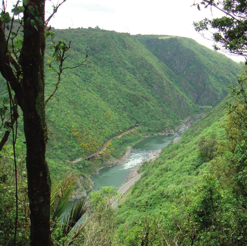
Manawatu Gorge Scenic Reserve (the Gorge)
The Gorge covers 606.17 ha and is approximately 12 km to the northeast of Palmerston North
along State Highway 3 (see Figure 5). It forms a link between the Manawatu province on the
western side of the lower North Island and the northern Wairarapa province on the eastern
side.
The Gorge contains an interesting mix of forest species. Tawa and podocarp species dominate,
while nīkau palms (Rhopalostylis sapida) give the forest a tropical feel. Flowers of the once-
common northern rātā (Metrosideros robusta) can be seen in December. Several regionally and
nationally rare plant species are also found in the reserve, including the giant maidenhair fern
(Adiantum formosum), which is found nowhere else in New Zealand. The large, rare beetle
Megadromus turgidiceps is also found here, as are the tūī (Prosthemadera novaeseelandiae),
miromiro/tomtit (Petroica macrocephala), kāhu/swamp harrier (Circus approximans) and
riroriro/grey warbler (Gerygone igata), and North Island kākā (Nestor meridionalis
septentrionalis) have also been seen flying over the bush.
Today, the Gorge and its surrounds comprise part of an inter-agency biodiversity project that
will see DOC, Horizons, Palmerston North City Council, Tararua District Council, On Track,
Transit and Ashhurst Action Group work together with the Governance Entity to protect the
native flora and fauna of this special area. The Gorge is also a Kiwi Guardians site.
Figure 5: Manawatu Gorge Scenic Reserve
19Pest control
Both aerial control using helicopters and ground control are carried out in the Gorge to control
possums, rats and stoats. In addition, goat (Capra aegagrus hircus) control is carried out by a
contractor and weed control is undertaken in partnership with Horizons. Possums are also
monitored in this area.
Trapping in the Gorge is maintained and monitored by volunteers from the Milson Scout
Troop and Ashhurst Volunteer stoat trappers, with support from DOC.
Scheduled track and structure maintenance
The Manawatu Gorge Walk is a Gateway Destination. Planned work on the tracks and
structures that are currently in place includes:
• regravelling Tawa Loop track – location of a toilet to be decided
• regravelling Big Slip Lookout track
• exploring the development of a new Boundary Loop Track
• developing Te Ara o Mahurangi and working in partnership with the Mountain Bike
Club and Horizons
• carrying out vegetation maintenance
• removing a rimu log that fell near the Whatonga statue due to wind – DOC has
sought permission from iwi to gift the log to the carvers who completed the
Palmerston North Office carvings to be used for traditional Māori cultural purposes.
Ruahine Forest Park
The Ruahine Forest Park stretches almost 100 km from the Taruarau River in the north to the
Manawatu Gorge in the south (see Figure 6). It can be accessed from the eastern and western
sides.
The Ruahine Forest Park is characterised by a cool, cloudy climate with occasional heavy rain.
The area is known for strong winds, particularly in the southern ranges, and there can be snow
at any time of the year.
The forests in the north generally comprise a mix of podocarp and beech species, including
rimu (Dacrydium cupressinum), miro (Prumnopitys ferruginea), mātai (P. taxifolia), red beech
(Fuscospora fusca) and mountain beech (F. cliffortioides), with kahikatea dominating swampy
areas. On the wide, open tops, the forests give way to subalpine shrublands, tussock grasslands
and summer-flowering herbfields. Further south, wet and cloudy conditions favour the dense
growth of tūpare/leatherwood (Olearia colensoi), forming the largest unbroken expanse of this
species in New Zealand. Throughout the park, the understory is rich in ferns and small trees
and shrubs such as horopito (Pseudowintera spp.), rangiora (Brachyglottis repanda) and
māhoe.
The sights and sounds of numerous native birds can be found in this area, including the tūī,
kererū/New Zealand wood pigeon (Hemiphaga novaeseelandiae), miromiro/tomtit,
pīwakawaka/fantail (Rhipidura fuliginosa), riroriro/grey warbler, korimako/bellbird (Anthornis
melanura) and kākāriki/parakeets (Cyanoramphus spp.). The rare whio/blue duck
(Hymenolaimus malacorhynchos) lives in mountain streams, and the kārearea/New Zealand
falcon (Falco novaeseelandiae) and North Island kākā can be found at higher altitudes. Native
animals in the park include moko/lizards, pekapeka/bats and large land snails.
20Operational report for Rangitāne o Manawatū Settlement Trust 2016–2017
There are many activities to do in the park, such as walking, tramping, hunting, camping,
mountain biking, skiing, fishing, four-wheel driving (4WD) and heritage site-seeing.
Commercial operators for transport, guided adventures and tours, and outdoor education have
been approved by DOC to operate in the Ruahine Forest Park.
Figure 6: Ruahine Forest Park
Pest control
Pest control is undertaken in the southwest and southeast of the Ruahine Forest Park.
Goat/stock control and old man’s beard (Clematis vitalba) and lodgepole pine (Pinus contorta)
surveillance are carried out in both areas. In addition, pest control for whio/blue duck
protection and the aerial control of old man’s beard is carried out in the southwest of the park,
and the Central Hawke’s Bay branch of Forest and Bird trapping lines are maintained in the
southeast.
Monitoring is also carried out in both areas for North Island brown kiwi during the nights in
winter and for short-tailed bats (Mystacina tuberculata) during the nights in summer.
Scheduled track and structure maintenance
The following work is planned on tracks and structures in the park:
• toilet maintenance at Oroua car park (Local Treasure)
21• weed spraying at Beehive Creek Picnic Area (Local Treasure)
• maintenance of Takapari (4WD) road by contractors (Local Treasure)
• track and lawn maintenance at Kashmir carpark to Moorcock Saddle road; Tamaki
West roadend; Kumeti roadend and campsite; and Coppermine roadend (Local
Treasures)
• track maintenance and monthly hut servicing at Rangiwahia Track (and hut);
Longview Track (and hut); Kahikatea Walk, Pohangina Valley; and Pohangina Base
Booked Accommodation and Campsite (Gateway Destinations)
• track maintenance by contractors, huts adopted by community groups, liaison with
outside agencies (ie tramping clubs, Land Search and Rescue, police, landowners,
WARO) and sign replacement at the following backcountry sites:
– Tukituki to Hinerua ridge track; Tukituki River to Daphne Hut track
– Daphne Spur to Daphne Hut to Howletts Hut; Daphne Hut to Main Range
track; Daphne carpark to Daphne Hut track
– Moorcock Saddle to Longview Hut track
– Longview hut to Otumore route; Longview Hut to Makaretu Hut track
– Moorcok Saddle to Awatere Hut
– Apiti Track
– Stanfield Hut to Birch Whare track; Stanfield Hut / Takapari Road / Tamaki
River track
– Homes Ridge track
– Tamaki West roadend to A-frame hut track
– Roki Track
– Kumeti to Maharahara track
– Kiritaki Hut to Matanginui track
– Granges Track
– Coppermine loop track; Coppermine loop track to Mangaatua Stream track
– Coppermine Track
– Wharite Peak Track
– Daphne Ridge track
– Poutaki Track
– Happy Daze Hut.
Partnerships and sponsorship
Alice Nash Memorial Heritage Lodge in the southwest of the park is a Toyota Kiwi Guardians
site.
Volunteer activities in the Ruahine Forest Park are supported by the DOC Community Fund.
22Operational report for Rangitāne o Manawatū Settlement Trust 2016–2017
Tararua Forest Park
The Tararua Range provides an outstanding variety of tramping, hunting and walking
opportunities in a wild, natural landscape. The Tararua Forest Park covers 116,535 ha, making it
the largest conservation park managed by DOC in the North Island (see Figure 7). There are
three main entrances to the park: Holdsworth on the Wairarapa/eastern side, Otaki Forks on
the Kapiti/western side and Waiohine Gorge on the Wairarapa/southeastern side.
The Tararua Range comprises alpine tussock grasslands, subalpine shrublands, montane
miro/kāmahi (Weinmannia racemosa) forests, beech forests and lowland broadleaved forests
(with emergent podocarps). Native birds, pekapeka/bats, giant snails, weevils, slugs and fish
inhabit this region.
DOC Manawatu Operations District
DOC Wairarapa Operations District
Figure 7: Tararua Forest Park
The blue highlighted section in Figure 7 is the Conservation Protocol Area of interest, while the
pink boundary identifies the DOC operations districts – in this case, the Wairarapa and
Manawatu.
Scheduled track and structure maintenance
DOC Manawatu did not carry out any work in the Tararua Forest Park in 2016/17. DOC
Wairarapa continued with ongoing maintenance of the track and hut, including the removal of
a stile from the area that is part of the Te Araroa Track, due to it being surplus to requirements.
234. Implementing the Treaty settlement
In 2016/17, DOC achieved additional Treaty settlement implementation work that was agreed
between DOC and the Rangitāne o Manawatū Settlement Trust. These initiatives included:
• a survey to redefine the boundary of Awapuni Conservation Area
• the procurement of DOC 200 traps for Mārima Peak pest control
• the establishment of a DOC / Rangitāne o Manawatū Memorandum of
Understanding (MoU) for the development of a conservation management plan
• development of a natural heritage plan for Pukepuke Lagoon Conservation Area
• a geomorphological assessment for Pukepuke Lagoon Conservation Area.
Awapuni Conservation Area (Awapuni) boundary redefinition survey
Awapuni covers 3.4 ha and includes pasture and exotic vegetation. It is made up of four
properties, each of which has previously been leased for grazing under DOC’s administration.
The physical boundaries of Awapuni are unclear and fencing is poor or non-existent.
The land has low conservation value, but this site is of cultural significance to Rangitāne o
Manawatū. Consequently, Awapuni was vested in fee simple to Rangitāne o Manawatū on 2
March 2017 as part of their Treaty settlement. The physical boundaries of Awapuni need to be
resolved before this transfer.
DOC sought advice from the Statutory Land Management team about why a survey had not
been completed previously for this site. It was noted that the issue of a Computer Freehold
Register (CFR) for these parcels would not affect the titles held by the adjoining owners, and
that neither party would lose or gain land as the existing boundary positions have not changed.
It was also noted by the Office of Treaty Settlements that the internal fences were disclosed by
DOC and the Governance Entity and there were no concerns. Therefore, if there was a desire to
have the boundary between the Cultural Redress site and the adjoining private land ‘identified’
on the ground, it would fall upon an affected party to engage a surveyor.
Truebridge Associates Limited was commissioned to complete the boundary redefinition
survey and lodge cadastral survey data for Awapuni. The survey process included carrying out
a boundary redefinition survey of the parcels involved, marking the legal boundary with pegs
and lodging the cadastral survey dataset with Land Information New Zealand (LINZ) so that
there was a record of the marks.
DOC sought notification and approval from the following neighbouring owners: Christine
Lillian Eales, Manawatu Racing Club and Palmerston North City Council. DOC was advised by
the Governance Entity that Palmerston North City Council was currently going through a plan
change to rezone one parcel of land from Rural to Race Training Zone. Details of this plan
change were sent to the surveyor who advised that this would not affect the work to be carried
out.
The boundary redefiniton survey was completed and the cadastral survey data lodged with
LINZ at the end of June 2017. DOC then forwarded the cadastral survey data to the
Governance Entity at the start of July 2017.
24Operational report for Rangitāne o Manawatū Settlement Trust 2016–2017
Mārima Peak pest control
Pest control programmes will help build the capability and education of the Governance
Entity’s whānau, hapū and iwi and will also have cultural benefits. DOC rangers met with Te Ao
Turoa Environmental Officer Paul Horton on 15 June 2017 to discuss the pest control
aspirations of Rangitāne o Manawatū.
DOC would like to support the Governance Entity where there is a conservation benefit and
the Governance Entity has a duty as a result of its Treaty settlement. Mairehau Peak, Mārima
Peak, Aruwaru Peak and Ngāwhakaraua Peak were vested to the Governance Entity to be
managed as scenic reserves.
The Mārima Peak site selection was based on the following criteria: access, the presence of pest
animals, existing pest control in the vicinity and the benefits of treating a small area. These
criteria reduced the proposal down to two sites: Mārima Peak (Tararua), which is close to
existing pest control and has relatively good access; and Wharite (Ruahine), which is near
existing operations, including whio/blue duck protection and Manawatū River work, and has
road access.
DOC noted that according to Rangitāne o Manawatū settlement legislation, Wharite will be
subject to a conservation covenant and so a trapping programme here would complement this
requirement.
Palmerston North City Council is currently undertaking a pest control programme at Turitea,
which adjoins Mārima Peak. Paul Horton is actively involved in this programme and advised
that pest control at Mārima led by the Governance Entity would complement this work. It was
noted that Rangitāne o Manawatū has the capacity, experience and knowledge to service any
traps at Mārima Peak, and also has ready access to the site. DOC 200 traps should be used for
pest control at Mārima Peak.
A letter was sent to the Governance Entity Chief Executive Officer Danielle Harris to advise of
the agreement between DOC and the Governance Entity that DOC will grant and purchase on
behalf of the Governance Entity 150 DOC 200 traps. The Governance Entity will then need to
implement and manage a pest control programme at Mārima Peak to help achieve the
following outcomes:
• contribute to the New Zealand Government’s Predator Free 2050 initiative
• preserve indigenous flora and fauna at Mārima Peak, which has been returned to
Rangitāne o Manawatū as a scenic reserve
• complement existing pest control work that Rangitāne o Manawatū currently
undertakes alongside Palmerston North City Council, schools and the community in
the area surrounding Mārima Peak
• enhance social and cultural values.
DOC and Rangitāne o Manawatū Memorandum of Understanding (MoU)
The Rangitāne o Manawatu Claims Settlement Act 2016 came into effect on 2 March 2017. The
settlement contains obligations for DOC and the Governance Entity, including within the
specific Conservation Protocol and property redress sections, and also identifies areas of
potential collaboration. The Governance Entity has indicated a desire to have a conservation
plan for its area of interest and has aspirations that capture many of these obligations and
opportunities. DOC supports these aspirations.
25The purpose of this MoU is to develop a conservation plan. DOC recognises that this is an
ambitious project that needs to be properly developed and so has committed to an initial fund
to enable the Governance Entity to undertake project development work, including developing
the project scope, establishing the project plan, providing a full budget and timeframe, and
compiling a project team. Once the project development stage is completed, DOC will consider
providing further support.
Developing the Pukepuke Lagoon Conservation Area (Pukepuke)
Natural Heritage Plan
Pukepuke is classified as a Stewardship Area under the Conservation Act 1987 and is managed
by DOC to meet the intermediate outcome objective ‘a full range of New Zealand’s ecosystems
is conserved to a healthy functioning state’.
Pukepuke has very significant historic heritage values and is a significant site for Rangitane o
Manawatu. From a Rangitane o Manawatu perspective, an immense amount of work is
required to fully restore this ecosystem to a healthy functioning state.
Several bird species that are seldom found elsewhere in the Manawatū region occur at
Pukepuke, including New Zealand dabchick (Poliocephalus rufopectus) and Australasian
bittern (Botaurus poiciloptilus). Threatened or At Risk plant species have also previously been
recorded at the site and may still be present, including horned pondweed (Zannichellia
palustris) and dwarf musk (Mazus novaezeelandiae subsp. novaezeelandiae). In addition, there
is a large population of shortfin eel (Anguilla australis) at this site, and longfin eel (A.
dieffenbachii) and inanga (Galaxias maculatus) are also present. Pukepuke is also used for
game bird hunting between May and August.
Working in partnership to restore Pukepuke
There is a desire for DOC and Rangitane o Manawatu to work in partnership to restore
Pukepuke, with a vision of the site being returned to a healthy functioning state by 2030.
However, there is no recently compiled, cohesive document for integrated management here –
the last management plan was drafted in 1987.
In early 2017, field surveys were completed at Pukepuke to collect information on the current
state and threats to the site. Subsequently, Wildlands met with the Governance Entity
representatives Danielle Harris and Paul Horton to discuss aspirations and management
issues. As a result of this work, a natural heritage report was produced, which included:
• a description of the site, including background information and its physical
characteristics
• an outline of the site’s ecological values and threats
• an assessment of what a healthy functioning state may look like for Pukepuke
• goals, objectives and actions
• milestones and direction for day-to-day work.
DOC would like to support the Governance Entity in any future work at Pukepuke.
26Operational report for Rangitāne o Manawatū Settlement Trust 2016–2017
Geomorphological assessment of Pukepuke
Knowledge of the geomorphological processes that have shaped Pukepuke’s physical
characteristics over thousands of years is fundamental to formulating and enacting future
management.
Roger Shand from Coastal Systems Ltd was commissioned in May 2017 to complete a
geomorphological assessment of Pukepuke that describes and predicts the hydrology and
naturally occurring changes at the site. At the time of writing, the draft assessment has been
completed and is awaiting feedback from iwi and DOC.
Geomorphological assessments underpin a range of environmental studies, including coastal
environment definitions, natural character appraisals, outstanding landform and landscape
identifications, hazard assessments, management investigations, and tangata whenua interests.
In particular, they explain:
1. what is there – a description of the current landform and its geographical setting
2. why it is there – an explanation of why the current landform is as it is, ie the
formative processes
3. how it will change – prediction of how the landform may change in the future
4. initial recommendations relating to restoration management.
27Appendix 1
Active permits that apply generally to the Protocol Area are included in Table 1.1 below. Each of
these is subject to special conditions, which might include the:
• period of notification to District Operations Manager prior to proceeding with an
activity
• period required for iwi consultation
• type of activity.
Any active permits specific to a site can be found under that site in the table. In the 2016/2017
year, DOC received 114 concession applications for activities in the Protocol Area.
Table 1.1: Active concessions on public conservation lands (PCL) in the Rangitāne o Manawatū area of
interest.
Permit number Permit type Site(s) Activity Term
47961-DOA Wildlife Act Foxton Permit to obtain six specimens 1/12/2015 to
permit – low each of tūī (Prosthemadera 30/11/2025
impact novaeseelandiae) and
kererū/New Zealand wood
pigeon (Hemiphaga
novaeseelandiae) for customary
use (to make korowai). Remains
of the birds will be buried.
45854-DOA Wildlife Act Feilding Permit to hold the wingbones of 1/12/2015 to
permit – low toroa/albatross for customary 30/11/2025
impact use – to craft as uhi (Māori
tattooing chisels) and/or kōauau
(Māori flutes).
50560-FAU Wildlife Act All PCL in North and Permit to capture, handle and 22/08/2016 to
permit – high South Islands survey frog and moko/lizard 30/11/2022
impact species.
50606-CAP Wildlife Act Tokomaru Permit to hold moko/lizards in 5/09/2016 to
permit – low permanent captivity. 4/09/2026
impact
36555-FAU Wildlife Act Victoria Esplanade, Permit to rehabilitate and 29/07/2013 to
permit – high Palmerston North release previously sick and 28/07/2043
impact injured threatened/endangered
species at a purpose-built
hospital.
39448-CAP Wildlife Act Hokowhitu, Permit to mount dead New 1/10/2014 to
permit – low Palmerston North Zealand dabchick 30/09/2024
impact (Poliocephalus rufopectus) and
kāhu/swamp harrier (Circus
approximans) specimens and
use for education purposes.
48320-FAU Wildlife Act All public and private Nationwide authority under the 1/03/2016 to
permit – low conservation lands in Wildlife Act to capture, band 28/02/2026
impact New Zealand and release birds on public and
non-public conservation lands.
Note: This authority is only for
the capture, measurement and
recording, banding, and
subsequent release of birds.
WA-29460-DOA Wildlife Act AgResearch, Authority to hold one mounted 6/12/2002 to
permit – low specimen of a kererū/New
28Operational report for Rangitāne o Manawatū Settlement Trust 2016–2017
impact Palmerston North Zealand wood pigeon. 6/12/2052
WA-28309-DOA Wildlife Act Foxton Beach School Authority to hold one mounted 16/07/1998 to
permit – low specimen of a northern royal 16/07/2048
impact albatross (Diomedea sanfordi).
WA-15814-DOA Wildlife Act Cloverlea, Palmerston Permit to hold feathers. 20/01/2005 to
permit – low North 19/01/2105
impact
WA-28304-DOA Wildlife Act Institute of the Pacific Authority to hold mounted 14/04/1998 to
permit – low United New Zealand, specimens of two North Island 14/04/2048
impact Palmerston North kākā (Nestor meridionalis
septentrionalis) and one
morepork (Ninox
novaeseelandiae).
CA-32062-FAU Wildlife Act Non-PCL Re-issue of permit to capture 1/11/2011 to
permit – low associated with the Landcare 31/10/2021
impact national permit CA-31615-OTH.
WA-15223-DOA Wildlife Act Takaro, Palmerston Permit to hold feathers. 1/10/2004 to
permit – low North 1/10/2104
impact
35196-FAU Wildlife Act Ruahine Forest Park Permit to capture, hold, transfer, 31/12/2012 to
permit – low release and take samples of all 31/12/2018
impact moko/lizard species pursuant to
section 53 of the Wildlife Act
1953.
WA-16482-DOA Wildlife Act Awapuni, Palmerston Permit to hold feathers. 17/05/2005 to
permit – low North 16/05/2105
impact
WA-29214-DOA Wildlife Act Palmerston North Authority to hold one mounted 27/09/2000 to
permit – low Boys’ High School specimen of a New Zealand 27/09/2050
impact kingfisher (Todiramphus
sanctus).
WA-29213-DOA Wildlife Act Palmerston North City Authority to hold one mounted 18/08/2000 to
permit – low Council specimen of a banded rail 18/08/2050
impact (Gallirallus philippensis).
WA-29218-DOA Wildlife Act Palmerston North City Authority to hold mounted 20/03/2002 to
permit – low Council specimens of one tūī, one 20/03/2052
impact shining cuckoo (Chrysococcyx
lucidus), one New Zealand
kingfisher, one pair of whio/blue
ducks (Hymenolaimus
malacorhynchos) and ducklings,
and North Island brown kiwi
(Apteryx mantelli) eggs.
WA-12182-DOA Wildlife Act Ashhurst Permit for the cultural use of 19/02/2003 to
permit – low feathers. 18/02/2103
impact
WA-14169-DOA Wildlife Act Palmerston North City Permit to hold stuffed 27/01/2004 to
permit – low Council Aviaries kererū/New Zealand wood 27/01/2104
impact pigeon.
WA-14618-DOA Wildlife Act Palmerston North City Permit to hold stuffed morepork 31/05/2004 to
permit – low Council Aviaries and korimako/bellbird 30/05/2104
impact (Anthornis melanura).
WA-15868-DOA Wildlife Act Te Manawa Museum Museum specimens permit. 31/01/2005 to
Permit - Low of Art, Science and 31/01/2100
Impact History, Palmerston
29North
WA-29712-DOA Wildlife Act Palmerston North Authority to hold one mounted 24/09/2008 to
permit – low specimen of a little blue penguin 24/09/2058
impact (Eudyptula minor).
35818-FAU Wildlife Act Ruahine Forest Park Re-issue of a national 1/03/2013 to
permit – low authorisation for trapping 28/02/2018
impact (leghold, kill and live capture) of
ferrets (Mustela putorius furo) on
all DOC-managed land.
36890-CAP Wildlife Act Tokomaru Permit to hold protected 24/07/2013 to
permit – low moko/lizards in captivity for 23/07/2023
impact educational display purposes.
38895-FAU Wildlife Act All land within DOC’s Authority to band all seabirds, 1/06/2014 to
permit – low Manawatu office waders and passerines in the 31/05/2024
impact boundary lower North Island region.
48443-DOA Wildlife Act Feilding Authority to hold spoonbill 13/12/2015 to
permit – low (Platalea regia) feathers for the 13/12/2025
impact purpose of cultural use.
45715-CAP Wildlife Act Foxton Authority to catch, handle and 25/02/2016 to
permit – low take samples from protected 23/02/2026
impact species of moko/lizard for
species management and
education purposes.
49787-DOA Wildlife Act Massey University Permit to use kiwi eggshells for 9/06/2016 to
permit – low research. 8/06/2026
impact
35227-FAU Wildlife Act Palmerston North, Application to hold and release 7/11/2012 to
permit – low Feilding pheasants (Phasianus 6/11/2017
impact colchicus).
36213-CAP Wildlife Act Te Manawa Museum Permit to hold live Wellington 6/05/2013 to
permit – low of Art, Science and green geckos (Naultinus 5/05/2023
impact History, Palmerston punctatus) and dead
North specimens.
48247-DOA Wildlife Act Featherston Street, Permit to hold one dead 11/11/2015 to
permit – low Palmerston North kāhu/swamp harrier. 10/11/2020
impact
50017-DOA Wildlife Act Aorangi, Feilding Permit to hold dead specimens, 28/04/2016 to
permit – low or parts thereof, for customary 29/04/2026
impact purposes.
38732-FAU Wildlife Act All land within DOC’s National authorisation to catch 1/01/2017 to
permit – low Manawatu office alive and mark gamebirds. 31/12/2036
impact boundary
52376-DOA Wildlife Act Aokautere, Permit to hold pūkeko 16/11/2016 to
permit – low Palmerston North (Porphyrio melanotus) and 16/11/2026
impact toroa/albatross feathers for
cultural purposes.
49788-DOA Wildlife Act Takaro, Palmerston Permit to hold and use feathers 18/03/2016 to
permit – low North and other body parts of dead 18/03/2026
impact native birds.
39991-FAU Wildlife Act Nationwide Permit to handle, weigh, 12/01/2015 to
permit – low measure and photograph (for ID 11/01/2025
impact purposes) protected species of
herpetofauna at events
organised by the Society for
Research on Amphibians and
Reptiles in New Zealand (chiefly
30You can also read