Rylstone Region
                                       Coal Free
                                      Community

           Rylstone Region Coal Free Community
Hawkins Rumker PRIA Submission: Terrestrial Ecology
                                               Final
←
→
Page content transcription
If your browser does not render page correctly, please read the page content below
Rylstone Region
Coal Free
Community
Rylstone Region Coal Free Community
Hawkins Rumker PRIA Submission: Terrestrial Ecology
Final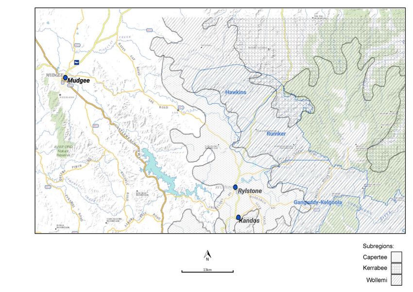
Rylstone Region Coal Free Community
Hawkins Rumker PRIA Submission: Terrestrial Ecology
Final

Prepared by:
Rylstone Region Coal Free Community
Parkinsons Road, Coxs Crown NSW 2849

August 2021

© Rylstone Region Coal Free Community. All rights reserved
Rylstone Region Coal Free Community has prepared this document for its sole use and for a specific purpose, each as expressly stated in the
document. No other party should rely on this document without the prior written consent of Rylstone Region Coal Free Community.
Rylstone Region Coal Free Community undertakes no duty, nor accepts any responsibility, to any third party who may rely upon or use this
document. This document has been prepared based on the best available information and Rylstone Region Coal Free Community’s
experience, having regard to assumptions that Rylstone Region Coal Free Community can reasonably be expected to make in accordance
with sound professional principles. Rylstone Region Coal Free Community may also have relied upon information provided by other third
parties to prepare this document, some of which may not have been verified. Subject to the above conditions, this document may be
transmitted, reproduced or disseminated only in its entirety.

                                        Rylstone Region Coal Free Community                            PAGE |ii
                                               Hawkins Rumker PRIA Submission:
                                                                                               Rylstone Region Coal Free
                                                            Terrestrial Ecology
                                                                                               Community - Final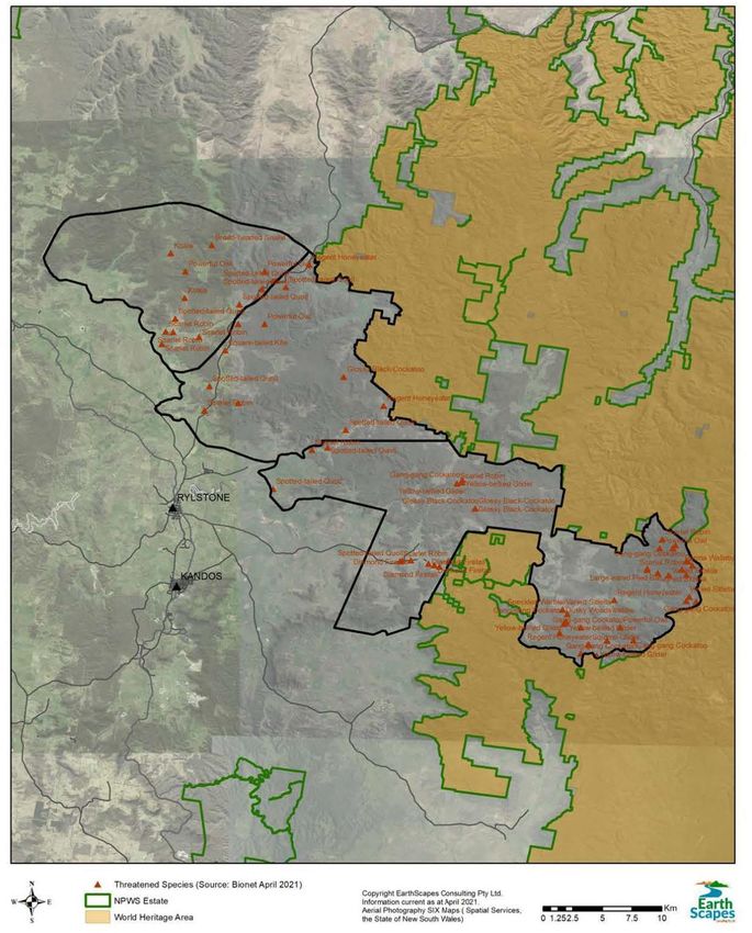
Document Control
Document Reference   RRCFC Submission Terrestrial Ecology Final V2.Docx

Project              Rylstone Region Coal Free Community

Document Type        Hawkins Rumker PRIA Submission: Terrestrial Ecology

Author               Rylstone Region Coal Free Community

Acknowledgement of Country
The RRCFC acknowledges that we live and work on Wiradjuri
Country.
We acknowledge the Wiradjuri peoples as the traditional
custodians of the land, and pay our respects to Elders past,
present and future.

                      Rylstone Region Coal Free Community          PAGE |iii
                           Hawkins Rumker PRIA Submission:
                                                              Rylstone Region Coal Free
                                        Terrestrial Ecology
                                                              Community - Final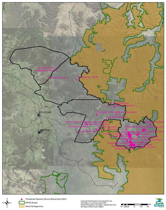
Executive Summary
2020 Strategic Statement and the PRIA process
The NSW Government June 2020 Strategic Statement on Coal Exploration and Mining outlines the
NSW Government’s approach to transitioning to renewable energy and supporting the economy and
aims to improve certainty about where mining should not occur. It identified 14 potential future coal
exploration release areas (NSW Government, 2020). The Hawkins and Rumker potential release areas
were identified in this Statement; the Ganguddy-Kelgoola area, which sits adjacent to Hawkins and
Rumker, is also identified in this statement.
Following the release of the Strategic Statement, the NSW Government Advisory Body for Strategic
Release has requested the Hawkins and Rumker areas be put through the Preliminary Regional Issues
Assessment (PRIA) process (Department of Planning, Industry and Environment (DPIE), 2021).
Ganguddy-Kelgoola is expected to go through the PRIA process in the near future once further
exploration is completed.
The PRIA process, also set out in the Strategic Release Framework (NSW Government, 2020), is an
initial assessment of social, environmental and economic matters relating to areas that could be
released for exploration. In theory, it involves engaging with interested and potentially impacted
stakeholders to identify issues for consideration.
RRCFC’s Terrestrial Ecology Submission
This report is the Rylstone Region Coal Free Community’s (RRCFC’s) submission to the PRIA process
addressing Terrestrial Ecology. Separate submissions for a range of other issues are also being
submitted by the RRCFC. The RRCFC recognises that releasing an area for coal exploration is a
precursor to opening up the area to coal mining and therefore, it is predominantly the mining phase
that is considered here.
Lag times, Data Paucity and Diversity
Any open cut mine would involve significant vegetation clearing and destruction of habitat,
particularly with the massive scale of deposit being considered in the Hawkins and Rumker areas.
Significant ecological impacts also occur with underground mining and these have a long lag time,
often decades before the extent of these becoming realised.
There is a lack of data available to accurately assess the full value of the terrestrial ecology, however
even from the available information, it is clear the Hawkins and Rumker areas are rich in biodiversity,
and the characteristics of the subregions are quite diverse and support a variety of threatened flora
and fauna species and ecological communities. Key threatened species include: koalas, spotted-tailed
quolls, brush-tailed rock-wallabies, regent honeyeaters, gang-gang cockatoos, glossy black-cockatoos,
and powerful owls amongst many others.
Regional Connectivity and the Greater Blue Mountains World Heritage Area
The Hawkins and Rumker areas are part of a linkage that connects conservation reserves such as
Goulburn River National Park in the northwest to reserves such as Wollemi, Yengo, Blue Mountains,
Dharug National Parks to the east and southeast. There is 33,254m of the Rumker proposed coal
release area that bounds the Greater Blue Mountains World Heritage Area. This provides for the
seasonal movements of as well as other species not yet listed under the Acts.
Before the NSW Government embarks on any mining, it must be able to demonstrate that there would
be no negative impacts on the Greater Blue Mountains World Heritage Area. However, given that the
ecological impacts of mining have a considerable time lag and are complex, predicting these impacts

                              Rylstone Region Coal Free Community            PAGE |iv
                                   Hawkins Rumker PRIA Submission:
                                                                       Rylstone Region Coal Free
                                                Terrestrial Ecology
                                                                       Community - Final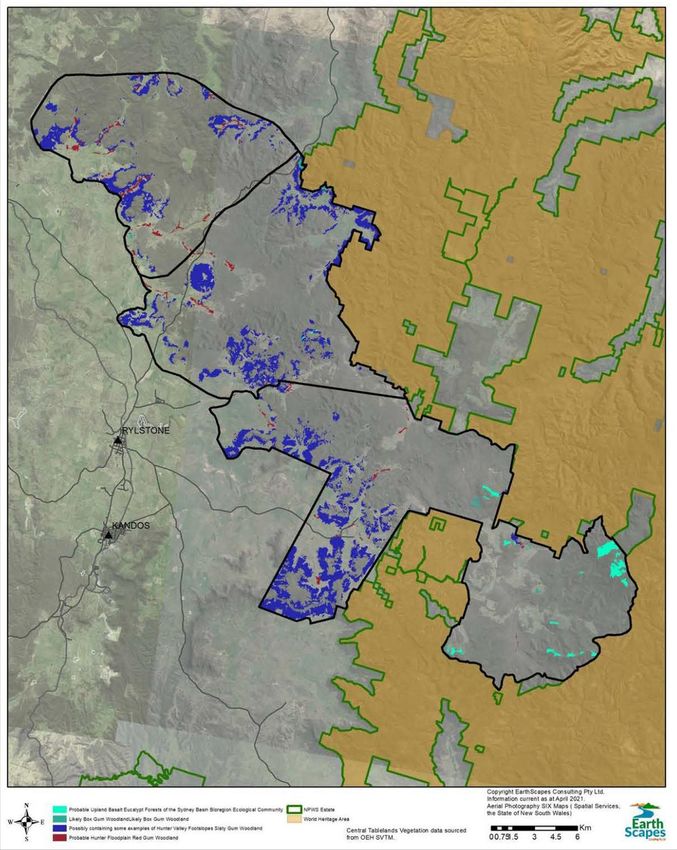
is fraught. Further, given the extraordinary diversity of the landscape in the Hawkins and Rumker areas
as outlined in this submission, it would be arrogance of the highest order to state that all impacts
could be accurately predicted let alone adequately managed.
Bushfire and Climate Change Resilience
Further information on the significance of the unburnt forests of the Hawkins and Rumker areas to
provide refuges to species that have been impacted by catastrophic fires is warranted. There should
also be an assessment of those areas that have not been burnt as these are the last refuges for some
of the heavily impacted flora and fauna species.
Flora and fauna presence will be differentiated to topography levels in that the biodiversity present
and moving along the watercourses and valley floors is a very different suite of species to that on
ridges and escarpment tops, thus this region has a high biodiversity potential compared to
environments that consist of basically one physical landscape. Not only does the altitude variation
within the region mean fauna have the ability to seasonally move around, but the relatively large
altitude differences also allow both flora and fauna some movement latitude when it comes to
possible climate change impacts in the future.
Inconsistency with environmental legislation
While the significance of the terrestrial ecology in the Hawkins and Rumker areas cannot be
determined accurately by a desktop review, the known and potential conservation values of the areas
indicates that, at this stage, it is clear that future mining and associated activities would have to
contend with a range of impacts on threatened species and an ecological community. The RRCFC
believes this cost is too high, it is not in line with the principles of ecologically sustainable development
and is contrary to the objects of the NSW Environmental Planning & Assessment Act 1979 (EP&A Act),
the NSW Biodiversity Conservation Act 2016 (BC Act) and Commonwealth Environment Protection and
Biodiversity Conservation Act 1999 (EPBC Act).
It is the RRCFC’s strongly held view that the PRIA should find that the environmental constraints in
Hawkins Rumker area are insurmountable and cannot be mitigated against by any future mining
activity. The PRIA should find that the proposed exploration areas should not be opened for
exploration under the Strategic Framework that it recommends against release of the proposed
areas, and the Advisory Board should rule that coal exploration should not proceed in the Hawkins
and Rumker areas.

                               Rylstone Region Coal Free Community              PAGE |v
                                     Hawkins Rumker PRIA Submission:
                                                                          Rylstone Region Coal Free
                                                  Terrestrial Ecology
                                                                          Community - Final
Contents
1| Introduction                                                                             1
  1.1 Preliminary Regional Issues Assessment (PRIA) Process                                 1
  1.2 PRIA Preparation                                                                      1
  1.3 Rylstone Region Coal Free Community                                                   2
    1.3.1 RRCFC                                                                             2
    1.3.2 Purpose of this report                                                            2

2| Existing Environment                                                                     3
  2.1 Bioregions                                                                            3
    2.1.1 Wollemi subregion                                                                 6
    2.1.2 Capertee subregion                                                                6
    2.1.3 Kerrabee subregion                                                                6
    2.1.4 Threatened flora and fauna species and ecological communities                     6
    2.1.5 Connectivity and species movement                                                 7

3| Flora                                                                                    8
  3.1 Vegetation communities                                                                8
  3.2 Ecological communities                                                                8

4| Threatened species                                                                      12
  4.1 Flora                                                                                12
  4.2 Fauna                                                                                17
    4.2.1 Threatened Grassy Woodland and Forest Birds                                      20
    4.2.2 Threatened Birds of Shrubby Forests and Woodlands                                20
    4.2.3 Threatened Predatory Diurnal Birds                                               21
    4.2.4 Threatened Nocturnal Birds                                                       21
    4.2.5 Threatened Mammals                                                               22
    4.2.6 Threatened Reptiles                                                              25

5| Discussion                                                                              26
  5.1 Discussion                                                                           26
    5.1.1 Connectivity and diversity                                                       26
    5.1.2 Paucity of data                                                                  26
    5.1.3 Significance                                                                     27
  5.2 Inconsistency with the Environmental Planning & Assessment Act 1979                  28
    5.2.1 Lack of information and ESD principles                                           28
    5.2.2 Contrary to the EP&A Act Objects                                                 29
    5.2.3 Cumulative impacts                                                               29

6| Conclusion                                                                              31

                            Rylstone Region Coal Free Community           PAGE |vi
                                 Hawkins Rumker PRIA Submission:
                                                                    Rylstone Region Coal Free
                                              Terrestrial Ecology
                                                                    Community - Final
List of Tables
Table 1 Threatened Ecological Communities (TECs) Areas                                     11
Table 2 Summary of threatened species by NSW Status                                        12
Table 3 Threatened Species in the Hawkins and Rumker areas                                 14
Table 4 Summary of threatened species by NSW Status                                        18

      List of Figures
Figure 1 The proposed exploration areas                                                     4
Figure 2 Bioregions and subregions in Hawkins and Rumker areas                              5
Figure 3 Vegetation Communities                                                             9
Figure 4 Threatened Ecological Communities (TECs).                                         10
Figure 5 Threatened Flora Species in the Hawkins and Rumker areas                          13
Figure 6 Threatened Fauna records in the proposed coal release areas                       19
Figure 7 Conceptual timeline showing time lags between first, second and third order
          impacts                                                                          28

                            Rylstone Region Coal Free Community          PAGE |vii
                                 Hawkins Rumker PRIA Submission:
                                                                    Rylstone Region Coal Free
                                              Terrestrial Ecology
                                                                    Community - Final
1| Introduction
1.1 Preliminary Regional Issues Assessment (PRIA) Process
The NSW Government’s Advisory Body for Strategic Release (ABSR) has asked the NSW Department
of Planning, Industry and Environment (DPIE) to prepare a Preliminary Regional Issues Assessment
(PRIA) (DPIE, 2021) to consider the benefits, opportunities, risks and constraints of releasing two
adjacent areas located near Rylstone in the Mid-Western Regional local government area (LGA).
These areas are shown in Figure 1 and include:
• Hawkins - an area of 14,900 ha located directly north of Rylstone, and
• Rumker - an area of 17,800 ha located directly northeast of Rylstone.
An initial assessment of resource potential undertaken by the Division of Mining, Exploration and
Geoscience within the Department of Regional NSW has identified coal resources within the Hawkins
and Rumker areas that could be mined by underground mining methods (DPIE, 2021). It is noted that
these areas could just as well be mined using aboveground methods.
In June 2020, the NSW Government released the Strategic Statement on Coal Exploration and Mining
(NSW Government, 2020). The Strategic Statement “outlines the NSW Government’s approach to
transitioning to renewable energy and supporting the economy and aims to improve certainty about
where mining should not occur.” It identified 14 potential future coal exploration release areas (NSW
Government, 2020).
Adjacent to Hawkins and Rumker potential release areas is the area of Ganguddy–Kelgoola, which is
slated to go through the PRIA process once further exploration is completed (NSW Government,
2020).
1.2 PRIA Preparation
The PRIA process is also set out in the Strategic Release Framework (NSW Government, 2020). It is
an initial assessment of social, environmental and economic matters relating to areas that could be
released for exploration. In theory, it involves engaging with interested and potentially impacted
stakeholders to identify issues for consideration.
DPIE has engaged Resource Strategies to undertake ‘preparation of a Preliminary Regional Issues
Assessment document in relation to a defined area that could be released for coal exploration’ for a
sum of $167,156 (NSW Government eTendering, 2021).
On its website Resource Strategies (2021) says it facilitates development approvals for major mining
and associated infrastructure projects and prepares comprehensive and timely environmental
assessment documentation with the assistance of recognised experts across all environmental fields.
The DPIE undertakes the PRIA and submits this to the ABSR, which considers potential release areas,
reviews reports and recommends assessment of the release of an area for resource exploration. The
ABSR makes recommendations to the Minister for Regional NSW and these are considered by Cabinet
and, if approved, the Minister for Regional NSW releases an area for exploration and invites companies
to apply for a prospecting title.
Rylstone Region Coal Free Community PAGE | 1
Hawkins Rumker PRIA Submission:
Rylstone Region Coal Free
Terrestrial Ecology
Community - Final1.3 Rylstone Region Coal Free Community
1.3.1 RRCFC
The Rylstone Region Coal Free Community (RRCFC) is a group of self-funded, like-minded local
residents, and supporters, of the Rylstone Region committed to stopping further exploration of coal
and approval of mines in our region. Our aim is to protect the land, heritage, culture and community
for now and future generations.
1.3.2 Purpose of this report
This report is the RRCFC’s submission to the PRIA process addressing Terrestrial Ecology. Separate
submissions for a range of other issues are also being submitted by the RRCFC. The RRCFC recognises
that coal exploration is a precursor to coal mining, and therefore, it is predominantly the mining phase
that is considered here.
This submission considers the Terrestrial Ecology of the Hawkins and Rumker areas. It clearly
demonstrates the significant ecological values of the Hawkins and Rumker areas. It shows how the
terrestrial ecology of the region would be destroyed and lost forever by a short term mine, and this
risk extends to the adjacent Blue Mountains World Heritage Area. The RRCFC believes this cost is too
high, it is not in line with the principles of ecologically sustainable development and is contrary to the
objects of the NSW Environmental Planning & Assessment Act 1979 (EP&A Act), the NSW Biodiversity
Conservation Act 2016 (BC Act) and Commonwealth Environment Protection and Biodiversity
Conservation Act 1999 (EPBC Act).
It is the RRCFC’s strongly held view that the PRIA should find that the environmental constraints in
Hawkins Rumker area are insurmountable and cannot be mitigated against by any future mining
activity. The PRIA should find that the proposed exploration areas should not be opened for
exploration under the Strategic Framework that it recommends against release of the proposed
areas, and the Advisory Board should rule that coal exploration should not proceed in the Hawkins
and Rumker areas.
Rylstone Region Coal Free Community PAGE | 2
Hawkins Rumker PRIA Submission:
Rylstone Region Coal Free
Terrestrial Ecology
Community - Final2| Existing Environment
Hawkins and Rumker areas both straddle the Great Dividing Range, with each having a portion of their
catchments falling east, into the Upper Hunter catchment; and west, into the Cudgegong River and
Lawson Creek catchments (Figure 1).
There is 33,254m of the Rumker proposed coal release area that bounds the Greater Blue Mountains
World Heritage Area.
2.1 Bioregions
The Hawkins and Rumker potential release areas are located in the northwest of the Sydney Basin
Bioregion, in an area bounded by the Brigalow Belt to bioregion to the north, and the South Western
Slopes to the west (https://www.seed.nsw.gov.au). Within the Sydney Basin Bioregion there are
several subregions, of which the Wollemi, Capertee and Kerrabee subregions occur in the Hawkins
and Rumker areas. The Wollemi subregion is the largest of the subregions in the Hawkins and Rumker
areas, with large areas of the Capertee and Kerrabee subregions occurring in the southwest and north
respectively (Figure 2).
Within the Sydney Basin Bioregion, the Hawkins and Rumker areas are predominantly in the Wollemi
subregion, with the Capertee subregion occurring in the southwest and Kerrabee subregion to the
north IBRA version 7 (2012). Due to the scale of the mapping, the boundaries are approximate and it
is possible that elements or transitional areas of both these sub regions occur elsewhere in the
Hawkins and Rumker areas.
Rylstone Region Coal Free Community PAGE | 3
Hawkins Rumker PRIA Submission:
Rylstone Region Coal Free
Terrestrial Ecology
Community - FinalFigure 1 The proposed exploration areas
Rylstone Region Coal Free Community PAGE | 4
Hawkins Rumker PRIA Submission:
Rylstone Region Coal Free
Terrestrial Ecology
Community - FinalFigure 2 Bioregions and subregions in Hawkins and Rumker areas
Rylstone Region Coal Free Community PAGE | 5
Hawkins Rumker PRIA Submission:
Rylstone Region Coal Free
Terrestrial Ecology
Community - Final2.1.1 Wollemi subregion
The Wollemi subregion is characterised by a Sandstone plateau with benched rock outcrops on
Hawkesbury Sandstone and Narrabeen Group sandstone, with a few volcanic necks. Soils are typically
sandy and infertile, however include areas of red-brown structured loam derived from basalt (NPWS
2003). The variation in the geology is reflected in the plant communities in the Hawkins and Rumker
areas, including characteristics species such inland scribbly gums on shallow sandy soils, scrubby, rocky
pagodas, forests on deeper soils on mid slopes containing tree such as ribbon gums, red stringybark,
grey gums through to areas of yellow box and Blakely's red gum on soils derived from basalt.
2.1.2 Capertee subregion
The Capertee subregion is located on Permian Shoalhaven Group conglomerates, sandstones, and
shales with coal at the base of the Sydney Basin. There are small areas of hilltop Tertiary basalt. The
Capertee subregion is characterised by wide valleys with low rolling hills below sandstone cliffs. Flat
top mountains in the valleys form pinnacles and remnant pieces of plateau, with shoulder slopes with
stone pillars or “pagodas” above steep canyons on tributary streams falling into gorges (NPWS 2003).
The Capertee subregion vegetation is characterised by woodlands and forests that support rough
barked apple, red stringybark, yellow box, Blakely’s red gum with shrubby to grassy understorey in
open valleys. Scribbly gum, red stringybark, red box and broad-leaved ironbark on talus slopes. Dwarf
casuarina, tea tree, and sedge on pagoda margins (NPWS 2003).
2.1.3 Kerrabee subregion
The Kerrabee subregion is characterised by sandstone plateau with cliffs falling into wide valleys with
sandy alluvial fill. There are volcanic necks forming circular depressions or low domes depending on
relative erodibility of adjacent rock types. Soils are shallow sandy to bare rock outcrop on plateau,
which contrast with the deep sands, loams and alluvial soils on coal measures. Basalt derived soils
have red brown structured loams and clay loams, often buried by slope debris where the volcanic
necks form depressions.
The Kerrabee subregion vegetation is characterised by yellow bloodwood, broad-leaved ironbark
rough-barked apple, grey gum with scribbly gum and shrubs and patches of dry heath on plateau.
Rough-barked apple forest red gum, grey box, white box, yellow box, fuzzy box. River oak occurs on
the main streams. Volcanic necks and domes always support distinctive local vegetation, usually a box
with grassy understorey (NPWS 2003).
2.1.4 Threatened flora and fauna species and ecological
communities
The characteristics of the subregions are quite diverse and support a variety of threatened flora and
fauna species and ecological communities, including:
• Threatened ecological community: at least one, being grassy woodlands and open forests,
including ‘White Box Yellow Box Blakely's Red Gum Woodland' as listed under the NSW
Biodiversity Conservation Act 2016 and the Commonwealth Environment Protection and
Biodiversity Conservation Act 1999.
Rylstone Region Coal Free Community PAGE | 6
Hawkins Rumker PRIA Submission:
Rylstone Region Coal Free
Terrestrial Ecology
Community - Final• Flora: the endangered flora Pultenaea sp. Olinda, Capertee stringybark (Eucalyptus
cannonii); small purple-pea (Swainsona recta).
• Birds: regent honeyeater (Anthochaera phrygia), diamond firetail (Stagonopleura guttata),
grey-crowned babbler (Pomatostomus temporalis temporalis), scarlet robin (Petroica
boodang), speckled warbler (Chthonicola sagittata), dusky woodswallow (Artamus
cyanopterus cyanopterus) and varied sittella (Daphoenositta chrysoptera), black-breasted
buzzard (Hamirostra melanosternon), gang-gang cockatoo (Callocephalon fimbriatum),
glossy black-cockatoo (Calyptorhynchus lathami), powerful owl (Ninox strenua), and the
square-tailed kite (Lophoictinia isura).
• Mammals: brush-tailed rock-wallaby (Petrogale penicillata), koala (Phascolarctos cinereus),
spotted-tailed quoll (Dasyurus maculatus).
• Reptile: broad-headed snake (Hoplocephalus bungaroides), Rosenberg's goanna (Varanus
rosenberi).
The Hawkins and Rumker areas also contain local records and potential habitat for several other flora
and fauna threatened species that are known to occur in the LGA and potentially have suitable
habitats in the Hawkins and Rumker areas. These include:
• Flora: Ausfeld's wattle (Acacia ausfeldii), Baeckea kandos, Creswick apple box (Eucalyptus
corticosa), Evans grevillea (Grevillea evansiana), scant pomaderris (Pomaderris
queenslandica), Mount Vincent mint-bush (Prostanthera stricta), Rylstone bell (Leionema
sympetalum) and silky swainson-pea (Swainsona sericea). One endangered population
Cymbidium canaliculatum in the Hunter Catchment is recorded.
• Birds: hooded robin (Melanodryas cucullata cucullata), brown treecreeper (Climacteris
picumnus victoriae), painted honeyeater (Grantiella picta), black-chinned honeyeater
(Melithreptus gularis gularis), turquoise parrot (Neophema pulchella), swift parrot (Lathamus
discolor), little lorikeet (Glossopsitta pusilla), barking owl (Ninox connivens), black-breasted
buzzard (Hamirostra melanosternon), spotted harrier (Circus assimilis), little eagle (Hieraaetus
morphnoides).
• Mammals: yellow-bellied glider (Petaurus australis), squirrel glider (Petaurus norfolcensis), the
grey-headed flying-fox (Pteropus poliocephalus), yellow-bellied sheathtail-bat (Saccolaimus
flaviventris), large-eared pied bat (Chalinolobus dwyeri), eastern false pipistrelle (Falsistrellus
tasmaniensis), Corben's long-eared bat (Nyctophilus corbeni), greater broad-nosed bat
(Scoteanax rueppellii), eastern cave bat (Vespadelus troughtoni), little bent-winged bat
(Miniopterus australis), large bent-winged bat (Miniopterus orianae oceanensis).
2.1.5 Connectivity and species movement
The Hawkins and Rumker areas are also part of a larger area of habitat that provides regional and local
movement corridors spanning to the east of the Great Dividing Range and west to Goulburn River
National Park. The Hawkins and Rumker areas also contain altitudinal ranges, from around 700mAHD
to over 1000mAHD. This provides for the seasonal movements of threatened species such as the
scarlet robin and gang-gang cockatoo, amongst a range of other species not yet listed under the Acts.
Further, there is 33,254m of the Rumker area that bounds the Greater Blue Mountains World Heritage
Area.
Rylstone Region Coal Free Community PAGE | 7
Hawkins Rumker PRIA Submission:
Rylstone Region Coal Free
Terrestrial Ecology
Community - Final3| Flora
3.1 Vegetation communities
Vegetation communities are shown in Figure 3. These communities are derived from the State
Vegetation Type Map (SVTM) from the NSW Office of Environment and Heritage (OEH) Central
Tablelands Region. This map was produced using available information, such as previous vegetation
surveys, aerial imaging and a variety of environmental information such as soil landscape mapping.
The map produced is a model of the distribution of each type. There are areas within this model that
have not been subject to adequate surveys and /or ground truthing, and as such the map cannot be
assumed to be accurate. Indeed, the State Vegetation Type Map is designed to be dynamically
improved and upgraded as new local information becomes available.
3.2 Ecological communities
Likely areas containing Threatened Ecological Communities (TEC) are displayed in Figure 4. The
following vegetation map categories were used to identify likely distribution of TEC (under NSW
legislation) or Endangered Ecological Communities (EECs) (under Commonwealth legislation):
i. The category 'Western Slopes Grassy Woodland' from the SVTM is used because it is likely to
encompass predominantly White Box Yellow Box Blakely’s Red Gum NSW TEC and Fuzzy Box
Woodland TEC (State), and the Box Gum Woodland Federal Endangered Ecological Community
(Federal).
ii. The category 'Eastern Riverine Forests' from the SVTM is used because it is likely to that it
encompasses some Hunter Floodplain Red Gum Woodland NSW TEC.
iii. The category 'North-west Slopes Dry Sclerophyll Woodlands' from the state vegetation
mapping is used because of the likelihood this includes some examples of Hunter Valley
Footslopes Slaty Gum Woodland NSW TEC.
iv. The Montane Basalt Cap Forest category from the Wollemi vegetation mapping is used
because it is likely to encompass predominantly the Upland Basalt Eucalypt Forests of the
Sydney Basin Bioregion EEC.
Appendix A of this report lists the PCT classes for the Hawkins and Rumker areas. Table 1 lists TECs for
each proposed coal release area.
It is possible that the identity of these communities may change following detailed field surveys, as
the existing maps are based on vegetation modelling, as discussed in section 3.1. While the identity is
not known with confidence at this stage, it is reasonable to suggest that whatever the identity of
community in question it is likely one of the TECs. This can be inferred from where they are found
within the landscape, given that threatened communities are found on more fertile soil landscapes,
which are typically cleared or in proximity to cleared areas on foot slopes, on valleys floors and volcanic
necks of Jurassic age and small areas of ridge top Tertiary basalt flows.
The areas displayed in Figure 4 and Table 1 cannot be considered at this stage to be exhaustive of
areas where TECs may occur for two reasons. Firstly, these maps are based on models that are not
ground truthed. Secondly, the information that has been used in the models from which this mapping
Rylstone Region Coal Free Community PAGE | 8
Hawkins Rumker PRIA Submission:
Rylstone Region Coal Free
Terrestrial Ecology
Community - Finalis derived is broad scale. Areas of volcanic influence have been observed in the local area which are
at a finer scale than available to the models, which leads to the possibility that small areas of TEC occur
Figure 3 Vegetation Communities
[Source: Earthscapes 2021]
Rylstone Region Coal Free Community PAGE | 9
Hawkins Rumker PRIA Submission:
Rylstone Region Coal Free
Terrestrial Ecology
Community - FinalFigure 4 Threatened Ecological Communities (TECs).
[Source: Earthscapes 2021]
Rylstone Region Coal Free Community PAGE | 10
Hawkins Rumker PRIA Submission:
Rylstone Region Coal Free
Terrestrial Ecology
Community - FinalIn the Hawkins and Rumker areas which will not be obvious until more detailed surveys are
conducted. It is therefore reasonable to conclude that there is a higher area of TEC than indicated
in this report.
Table 1 Threatened Ecological Communities (TECs) Areas
Area TEC Area
(Ha)
Hawkins Likely Box Gum Woodland Likely Box Gum Woodland 12
Hawkins
Possibly containing some examples of Hunter Valley Footslopes Slaty
1,250
Gum Woodland
Hawkins Probable Hunter Floodplain Red Gum Woodland 224
Rumker Likely Box Gum Woodland Likely Box Gum Woodland 38
Rumker
Possibly containing some examples of Hunter Valley Footslopes Slaty
2,007
Gum Woodland
Rumker Probable Hunter Floodplain Red Gum Woodland 97
Rumker Probable Upland Basalt Eucalypt Forests 6
TOTAL 3,634
[Source: Earthscapes 2021]
It should be noted that while the respective Final Determinations of the Scientific Committees to the
Biodiversity Conservation Act 2016 allow for both Hunter Floodplain Red Gum Woodland and Hunter
Valley Footslopes Slaty Gum Woodland to occur in the Hawkins and Rumker areas, the absence of
characteristic tree species such as the slaty gum (Eucalyptus dawsonii) on Bald Mountain and the
forest red gum (Eucalyptus tereticornis) more broadly (Mal Stokes pers obs; Bionet) indicates that the
TEC found in the Hawkins and Rumker areas is most likely 'White Box Yellow Box Blakely's Red Gum
Woodland' as listed under the NSW and Commonwealth Acts. Further, observation of vegetation
mapped as Montane Basalt Cap Forest in the Olinda area at or below 1000mASL included vegetation
commensurate with 'White Box Yellow Box Blakely's Red Gum Woodland'.
As detailed above, it is reasonable to suggest that whatever the identity of community in question it
is likely a TEC, and for the sake of simplicity, vegetation which may be one or more of the above
threatened communities will be referred to as 'Grassy Woodlands and Forests' or 'Grassy Woodlands'
in this report.
Rylstone Region Coal Free Community PAGE | 11
Hawkins Rumker PRIA Submission:
Rylstone Region Coal Free
Terrestrial Ecology
Community - Final4| Threatened species
4.1 Flora
Figure 5 displays the records for threatened flora species in the Hawkins and Rumker areas and Table 2
gives a summary of these.
Table 2 Summary of threatened species by NSW Status
Kingdom NSW Status Number of threatened
species recorded
Flora E1 2
Flora V 4
TOTAL 6
(V Vulnerable,E1 Endangered E4A Critically Endangered E4 Presumed Extinct E2 Endangered Population)
[Source: Earthscapes 2021]
These observations are not considered to be exhaustive of threatened flora in the Hawkins and
Rumker areas, due to the lack of a systematic flora survey. Further, at present more frequently visited
areas, such as Dunns Swamp - Ganguddy to the south, contain the bulk of records and the less
accessible areas to the north contain fewer records. As such, the number and distribution of records
cannot be seen as an accurate representation of the occurrence or distribution of threatened flora in
the Hawkins and Rumker areas, and it must be concluded there would be a vast number of threatened
species that have not been mapped in the Hawkins and Rumker areas and there may well be species
yet to be discovered in these areas.
There are three threatened flora species in the Hawkins and Rumker areas, the endangered Pultenaea
sp. Olinda, Capertee stringybark (Eucalyptus cannonii) and the small purple-pea (Swainsona recta).
The habitats for these species range over the Hawkins and Rumker areas, from the lower lying grassy
woodlands on fertile soils (small purple-pea) to the forests on mid to upper slopes (Capertee
stringybark) and up to the ledges and clefts associated with pagoda rock formations (Pultenaea sp.
Olinda) (Table 3).
One Endangered Population - Cymbidium canaliculatum in the Hunter Catchment has been observed
in the Hawkins and Rumker areas, in Ferntree Gully Reserve (Hill, L. & Peake, T. 2007). This species
has been associated with native vegetation on Permian sediments, which includes the endangered
ecological community ‘White Box Yellow Box Blakely's Red Gum Woodland’ (Table 3).
In addition to these are several threatened flora species that have discreet distributions to the south
((Baeckea kandos, Evans grevillea (Grevillea evansiana), Rylstone bell (Leionema sympetalum)).
Suitable habitats are likely to occur in the Hawkins and Rumker areas and there is a possibility these
species may occur there (Table 3).
In addition to these species, there are a several species known to occur in the Mid-Western Regional LGA
that have the potential to occur in the Hawkins and Rumker areas due to the likely presence of suitable
habitat. These include Ausfeld's wattle (Acacia ausfeldii), Creswick apple box (Eucalyptus corticosa), scant
pomaderris (Pomaderris queenslandica), Mount Vincent mint-bush (Prostanthera stricta) and silky
swainson-pea (Swainsona sericea) (Table 3).
Rylstone Region Coal Free Community PAGE | 12
Hawkins Rumker PRIA Submission:
Rylstone Region Coal Free
Terrestrial Ecology
Community - FinalFigure 5 Threatened Flora Species in the Hawkins and Rumker areas
[Source: Earthscapes 2021]
Rylstone Region Coal Free Community PAGE | 13
Hawkins Rumker PRIA Submission:
Rylstone Region Coal Free
Terrestrial Ecology
Community - FinalTable 3 Threatened Species in the Hawkins and Rumker areas
Species and Habitat Known to occur: Comment
Conservation Status
Pultenaea sp. Olinda Confined to ledges and clefts associated with pagoda rock
NSW – Endangered formations within a matrix of Eucalypt woodland. It occurs Yes
as a component of heath communities with or without a
sparse Eucalyptus and/or Callitris canopy. Soils are
shallow, sandy and infertile (Clarke 2013).
Small Purple-pea Associated with grassy understorey of woodlands and
(Swainsona recta) open-forests dominated by Blakely’s Red Gum (Eucalyptus Yes
blakelyi), Yellow Box (E. melliodora), Candlebark Gum (E.
NSW – Endangered rubida) and Long-leaf Box (E. goniocalyx).
Comm. - Endangered
Grows in association with understorey dominants that
include Kangaroo Grass, poa tussocks and spear-grasses
(NPWS 2018).
Capertee Stringybark Associated eucalypt species are diverse: Eucalyptus
(Eucalyptus viminalis, E. mannifera, E. polyanthemos, E. rossii, E. Yes
cannonii) blakelyi, E. sparsifolia, E. bridgesiana, E. dalrympleana, E.
NSW – Vulnerable melliodora, E. dives and Angophora floribunda.
Capertee Stringybark has a broad altitudinal range, from
around 450m to 1,050m. Within this range, the species
appears to tolerate most situations except the valley
floors (NPWS 2019).
Cymbidium This species has been observed in the Ferntree Gully Yes
canaliculatum in the Reserve (Mal Stokes pers comm.), which is within the
Hunter Catchment Hunter Catchment as per the listing under the BC Act.
NSW – Endangered Typically grows in the hollows, fissures, trunks and forks of
Population trees in dry sclerophyll forest or woodland, on Permian
Sediments. Most commonly found in vegetation similar to
or including the endangered ecological community (EEC)
‘White Box Yellow Box Blakely's Red Gum Woodland’.
Ausfeld's Wattle Associated species include Eucalyptus albens, E. blakelyi Potential for suitable
(Acacia ausfeldii) and Callitris spp., with an understorey dominated by habitat to occur.
Cassinia spp. and grasses. Grassy Woodlands.
NSW – Vulnerable (Eucalyptus albens, E.
In the Mudgee - Ulan area, A. ausfeldii is mostly found on blakelyi and Callitris spp.
flat ground in remnant roadside patches of woodland with Records occur in the
Eucalyptus albens (White Box), E. blakelyi (Blakely's Red Hawkins and Rumker
Gum) and Callitris spp. (Native Cypress Pines), with an areas).
understorey dominated by Cassinia spp. and grasses (NSW Most records north west of
Scientific Committee 2007). Hawkins and Rumker areas,
one record to south east in
roadside reserve.
Creswick Apple Box Highly localised distribution restricted to just a few sites Potential for suitable
(Eucalyptus east of Rylstone in the NSW Central Tablelands, near habitat to occur.
corticosa) Mount Coricudgy. Occurs in sclerophyll woodland on
NSW – Vulnerable shallow infertile soils on sandstone ridges associated with
the upper reaches of the Cudgegong River. It may be
Rylstone Region Coal Free Community PAGE | 14
Hawkins Rumker PRIA Submission:
Rylstone Region Coal Free
Terrestrial Ecology
Community - FinalSpecies and Habitat Known to occur: Comment
Conservation Status
locally frequent and is often associated with Eucalyptus
rossii (NPWS 2021).
Scant Pomaderris Found in moist eucalypt forest or sheltered woodlands Potential for suitable
(Pomaderris with a shrubby understorey, and occasionally along habitat to occur.
queenslandica) creeks. (NPWS 2019). At Kerrabee, occurs in a dry creek
NSW – Endangered line with Eucalyptus punctata, Acacia penninervis subsp.
penninervis, Bursaria spinosa and Dodonaea viscosa var.
cuneata, over a ground layer of Microlaena stipoides var.
stipoides, Digitaria diffusa and Dichondra repens.
Other collections have been made in the Bylong Valley,
adjacent to Wollemi (Bell & Driscoll 2014), and it is
suspected that this species is widespread yet occurs only
in small stands. (in: Bell, S (2019).
Silky Swainson-pea Found in Natural Temperate Grassland and Snow Gum A single record occurs close
(Swainsona sericea) (Eucalyptus pauciflora) Woodland on the Monaro. Found to the western Hawkins and
in Box-Gum Woodland in the Southern Tablelands and Rumker areas boundary.
NSW - Vulnerable South West Slopes. Sometimes found in association with Potential for suitable
cypress-pines Callitris spp. (NPWS 2019) habitat to occur.
Grassy Woodlands.
Mount Vincent Mint- The western population of this species have been located Potential for suitable
bush in heath or scrub communities along cliff edges, as an habitat to occur.
(Prostanthera understorey species within a range of forests, or in
stricta) adjacent transitional communities. Associated vegetation
including canopy species Eucalyptus blaxlandii, E. cannonii
NSW – Vulnerable and E. viminalis. Other associated species recorded at
Comm. - Vulnerable sites include Angophora floribunda, Eucalyptus punctata,
Brachychiton populneus, Acacia parvipinnula, Beyeria
viscosa, Microlaena stipoides and Cheilanthes species
(NPWS (2019). There is some contention that During
surveys of Wollemi NP, this species was not recorded here
nor anywhere else in the park (Bell 1998).
Gibson (2002) considers the Wollemi material to be a
separate species with close affinities to P. stricta, and
reports it for the creeklines around Mt Monundilla and
Gundy Wattle Flat (Bell 2008).
Acacia meiantha Only known from three disjunct locations, all within the Potential for suitable
Central Tablelands and each separated by more than habitat to occur.
NSW – Endangered 60km. These disjunct populations include Clarence, which Small number of
Comm. - Endangered covers an area of approximately 1 hectare; Mullions Range occurrences, variety of
State Forest north of Orange; and Carcalgong, which is forests types, unclear.
confined to 2.5km of road easements. Rarity indicates lower
likelihood of occurrence.
Clarence population occurs in an open eucalypt forest
(Eucalyptus dives and E. sieberi) and in an adjacent area of
mainly shrubs, where tree overstorey has been cleared
near power lines. Dense shrub layer is dominated by
Leptospermum trinervium with L. obovatum, Phyllota
squarrosa, Banksia spinulosa and Isopogon anemonifolia.
Rylstone Region Coal Free Community PAGE | 15
Hawkins Rumker PRIA Submission:
Rylstone Region Coal Free
Terrestrial Ecology
Community - FinalSpecies and Habitat Known to occur: Comment
Conservation Status
Populations at Carcalgong and Mullions Range State
Forest occur in the same broad Southern Tablelands Dry
Sclerophyll Forests vegetation class composition differ. At
Carcalgong Eucalyptus rossi, E. sparsifolia and E. lactea are
dominant with scattered E. goniocalyx. At Mullions Range
State Forest, the dominant overstorey species include
Eucalyptus rossi, E. mannifera, E. dives and E.
macrorhyncha (NPWS 2021).
Eucalyptus alligatrix The population is confined to an area of a few hectares Potential for suitable
subsp. miscella where an estimated 3,000 to 4,500 trees survive. Most of habitat to occur.
NSW – Vulnerable the population consists of moderately dense regenerating Rarity indicates lower
Comm. - Vulnerable stands following previous clearing, but there are also likelihood of occurrence.
larger scattered paddock trees, probably pre-dating
European settlement.
Grows in dry sclerophyll woodland on shallow relatively
infertile soils (grey brown loam with ironstone). It may
have been part of a more-extensive open woodland
community prior to the commencement of clearing and
grazing.
Associated trees include Eucalyptus macrorhyncha, E.
blakelyi, E. viminalis, E. bridgesiana, E. melliodora, E. rossii
and Angophora floribunda (NPWS 2019).
Ozothamnus This species has been collected at eight sites in a restricted Potential for suitable
tesselatus area over a range of 300 km2 (AVH, 2008). Grows in habitat to occur.
NSW – Vulnerable eucalypt woodland (Everett, 1992). This species occurs Grassy Woodlands and
Comm. - Vulnerable within the Hunter–Central Rivers (NSW) Natural Resource Derived Native Grassland.
Management Region. The distribution of this species Rarity indicates lower
overlaps with the White Box-Yellow Box-Blakely’s Red likelihood of occurrence.
Gum Grassy Woodland and Derived Native Grassland
EPBC Act-listed threatened ecological community (Dept
Agriculture, Water Environment 2008).
Brown Pomaderris Brown Pomaderris grows in moist woodland or forest on Potential for suitable
(Pomaderris clay and alluvial soils of flood plains and creek lines. habitat to occur in Grassy
brunnea) Woodlands.
NSW – Endangered The species has been found in association with Eucalyptus Small number of recordings
Comm. - Vulnerable amplifolia, Angophora floribunda, Acacia parramattensis, in the LGA. Considerable
Bursaria spinosa and Kunzea ambigua (NPWS 2017) gap until the most northern
records in Tuggolo SF /
Walcha Management Area.
Rarity indicates lower
likelihood of occurrence.
Silky Pomaderris There are only two Silky Pomaderris records in NSW that Potential for suitable
(Pomaderris sericea) give details of habitat so it is difficult to generalise about habitat to occur.
NSW – Endangered the habitat preferences of the species (NPWS 2021).
Comm. - Vulnerable Rarity indicates it is unlikely
The population at Wollemi National Park (NSW) occurs in to occur.
dry sheltered forest with Eucalyptus punctata, E.
sparsifolia, Acacia buxifolia, Acacia doratoxylon,
Dodonaea boroniifolia, Entolasia stricta and Poa affinis.
Rylstone Region Coal Free Community PAGE | 16
Hawkins Rumker PRIA Submission:
Rylstone Region Coal Free
Terrestrial Ecology
Community - FinalSpecies and Habitat Known to occur: Comment
Conservation Status
Soils are derived from Narrabeen Sandstones (Carter and
Walsh 2010).
Tarengo Leek Orchid Occurs on relatively fertile soils in grassy woodland or Thought to be much
(Prasophyllum natural grassland. Eucalyptus blakelyi (Red Gum) and E. reduced, due to clearing of
petilum) melliodora (Yellow Box) at Ilford. grasslands and grassy
NSW – Endangered woodlands.
Comm. - Endangered It is notable that the orchid occurs in relatively moist areas Rarity indicates lower
including the Ilford population (DECC 2010). likelihood of occurrence.
Baeckea kandos Known from several locations in Wollemi National Park, Species are located in a
NSW – Endangered immediately south of Dunns Swamp. discreet area to the south
Comm. - Endangered of the Hawkins and Rumker
Occurs in heathland on skeletal, infertile sandstone- areas.
derived soils, normally in association with pagodas.
Potential for suitable
At different locations, Baeckea kandos also occurs with habitat to occur.
another TSC Act listed endangered species, Pultenaea sp.
'Olinda'; and two vulnerable species Grevillea evansiana Any records in the Hawkins
and Leionema sympetalum (NPWS 2019). and Rumker areas would be
an extension of range.
Evans Grevillea The current northern limit is on private land north of Species are located in a
(Grevillea evansiana) Olinda, a short distance south east of the Hawkins and discreet area to the south
NSW – Vulnerable Rumker areas, which indicates there is some possibility of the Hawkins and Rumker
Comm. - Vulnerable this species may occur. areas.
Grows in a range of habitats including pagoda heath, dry Potential for suitable
sclerophyll forest or woodland and hanging swamps in habitat to occur.
sandy soils, usually over Hawkesbury sandstone (NPWS
2021). Any records in the Hawkins
and Rumker areas would be
an extension of range.
Rylstone Bell The Rylstone Bell is restricted to an area of western Species are located in a
(Leionema Wollemi National Park, from east of Rylstone to north of discreet area to the south
sympetalum) Glen Davis. Restricted to exposed rocky sandstone of the Hawkins and Rumker
NSW – Vulnerable formations known as pagodas. The species occurs in dry areas.
sclerophyll forest and probably also occurs in open or
closed heathland communities (NPWS 2019) Potential for suitable
habitat to occur.
Any records in the Hawkins
and Rumker areas would be
an extension of range.
Appendix B contains a complete listing of threatened species in the Hawkins and Rumker areas.
4.2 Fauna
Figure 6 and Table 4 displays the records for threatened fauna species in the Hawkins and Rumker areas.
These records only indicate that these species occur in the area. What these records do not show,
due to the lack of a systematic fauna survey, is the distribution of threatened species throughout the
Hawkins and Rumker areas. At present the more accessible areas, such as near roads, Dunns Swamp
- Ganguddy, contain the bulk of records and the less accessible areas contain fewer records. As such,
Rylstone Region Coal Free Community PAGE | 17
Hawkins Rumker PRIA Submission:
Rylstone Region Coal Free
Terrestrial Ecology
Community - Finalthe number and distribution of records cannot be seen as an accurate representation of the
distribution of threatened fauna in the Hawkins and Rumker areas, and it must be concluded there
would be a vast number of threatened species that have not been mapped in the Hawkins and Rumker
areas and there may well be species yet to be discovered in these areas.
The Hawkins and Rumker areas contain a diversity of habitats from grassy woodland and forests on
the more fertile soil landscapes on foot slopes, valleys floors, and Tertiary basalt flows, to thin sandy
soils supporting shrubby woodland and forests characteristic of sandstone vegetation more broadly.
The grassy woodland and forests are highly likely to contain TECs, as discussed in section 3.2.
The Hawkins and Rumker areas also contain a large amount of habitat. The variety of habitats –
importantly including TEC - occur alongside a range of threatened fauna species that rely on these
qualities to survive.
Table 4 Summary of threatened species by NSW Status
Kingdom NSW Status Number of threatened species recorded
Fauna E1 2
Fauna E4A 1
Fauna V 19
TOTAL
22
(V Vulnerable,E1 Endangered E4A Critically Endangered E4 Presumed Extinct E2 Endangered Population)
[Source: Earthscapes 2021]
Rylstone Region Coal Free Community PAGE | 18
Hawkins Rumker PRIA Submission:
Rylstone Region Coal Free
Terrestrial Ecology
Community - FinalFigure 6 Threatened Fauna records in the proposed coal release areas
[Source: Earthscapes 2021]
Rylstone Region Coal Free Community PAGE | 19
Hawkins Rumker PRIA Submission:
Rylstone Region Coal Free
Terrestrial Ecology
Community - Final4.2.1 Threatened Grassy Woodland and Forest Birds
One example of such a species that relies on the grassy woodlands and forests for survival is the regent
honeyeater (Anthochaera phrygia), whose conservation status at the State and Commonwealth level
is Critically Endangered. There are only three known key breeding areas, two of them in NSW -
Capertee Valley and Bundarra-Barraba regions. The regent honeyeater has been recorded in the
north and east of the Hawkins and Rumker areas, with a record close western boundary of the Hawkins
and Rumker areas (Bionet 2021).
The regent honeyeater is a flagship threatened woodland bird whose conservation will benefit a large
suite of other threatened and declining woodland fauna. The species inhabits dry open forest and
woodland, particularly box-ironbark woodland, and riparian forests of river she-oak. Regent
honeyeaters inhabit woodlands that support a significantly high abundance and species richness of
bird species. These woodlands have significantly large numbers of mature trees, high canopy cover
and abundance of mistletoes (NPWS 2021).
In addition to the regent honeyeater there are a range of woodland birds found in grassy woodland
and forests, including the diamond firetail (Stagonopleura guttata), grey-crowned babbler
(Pomatostomus temporalis temporalis), scarlet robin (Petroica boodang), speckled warbler
(Chthonicola sagittata), dusky woodswallow (Artamus cyanopterus cyanopterus) and varied sittella
(Daphoenositta chrysoptera) which have been observed in the Hawkins and Rumker areas.
In addition to these, there are several threatened woodland birds found in similar habitats in the Mid-
Western Regional LGA, including the hooded robin (Melanodryas cucullata cucullata), brown
treecreeper (Climacteris picumnus victoriae), painted honeyeater (Grantiella picta), black-chinned
honeyeater (Melithreptus gularis gularis), turquoise parrot (Neophema pulchella) and swift parrot
(Lathamus discolor) (NPWS 2017, NSW Scientific Committee 2009) which have suitable habitats in the
Hawkins and Rumker areas and have the potential to occur here.
4.2.2 Threatened Birds of Shrubby Forests and Woodlands
The Hawkins and Rumker areas contain a large amount of woodland and forest based on shallow,
sandy and infertile soils. These provide habitat for a range of threatened species known to occur in
the area, including the gang gang cockatoo (Callocephalon fimbriatum) and glossy black cockatoo
(Calyptorhynchus lathami). In addition to these, the little lorikeet (Glossopsitta pusilla) is also known
to occur in the Mid-Western LGA in similar habitats, has suitable habitat in the Hawkins and Rumker
areas and as such has the potential to occur in the area.
The little lorikeet forages primarily in the canopy of open eucalyptus forest and woodland, yet also
finds food in angophora, melaleuca and other tree species. Riparian habitats are particularly used, due
to higher soil fertility and hence greater productivity (NPWS 2017). The gang-gang cockatoo inhabits
eucalypt open forests and woodlands with an acacia understorey (NSW Scientific Committee 2008).
The glossy black cockatoo inhabits open forest and woodlands in the Hawkins and Rumker areas, with
black sheoak (Allocasuarina littoralis) and forest she-oak (A. torulosa) being important foods for the
glossy black cockatoo in the Hawkins and Rumker areas. Bald Mountain contains a large population of
drooping she-oak (A. verticillata) which is also an essential food source for this bird.
These species are dependent on large hollow-bearing trees for nest sites, and any activity that
decreases the numbers or the availability of these can threaten a local population. Further, both
species are threatened by removal of habitat (NPWS 2017), any activity that removes or modifies
foraging habitat also has the potential to negatively impact on these species.
Rylstone Region Coal Free Community PAGE | 20
Hawkins Rumker PRIA Submission:
Rylstone Region Coal Free
Terrestrial Ecology
Community - Final4.2.3 Threatened Predatory Diurnal Birds
The Hawkins and Rumker areas provide habitat for one threatened predatory diurnal bird, the square-
tailed kite (Lophoictinia isura), in addition to suitable habitat for several others known to occur in the
Mid-Western Regional LGA, the black-breasted buzzard (Hamirostra melanosternon), the spotted
harrier (Circus assimilis), and the little eagle (Hieraaetus morphnoides).
These predatory birds are associated with open forests and woodlands (square-tailed kite, black-
breasted buzzard) through to grasslands and farmlands (spotted harrier) and in the case of the little
eagle, open eucalypt forest, woodland or open woodland (NPWS 2017). The square-tailed kite and
black-breasted buzzard are also often found along timbered watercourses. The square-tailed kite is a
specialist hunter of passerines, especially honeyeaters, and insects in the tree canopy. The other birds
prey more broadly, on other birds, reptiles and mammals and occasionally large insects and carrion
(NPWS 2017).
The Hawkins and Rumker areas contain potential habitat for these species from the watercourses in,
or adjacent to farming landscapes, through to pastures and grasslands. The black-breasted buzzard
has also been sighted in nearby Olinda (S. Baguley pers. exp.) These areas are also likely to contain
TECs (section 3.2). In addition to these habitats, the Hawkins and Rumker areas also contains
woodland and forest habitats with an understorey and ground cover variously characterised by
grasses, fallen timber rocky areas and sparse shrub understorey. While these habitats are likely not
part of a TEC, nor necessarily directly or frequently used by these species, they form part of a mosaic
of vegetation that are likely to support the populations of passerines, other birds, reptiles and
mammals that these threatened birds prey on.
4.2.4 Threatened Nocturnal Birds
The Hawkins and Rumker areas provide known habitat for the powerful owl (Ninox strenua). The
barking owl (Ninox connivens) is also known to occur in the Mid-Western Regional LGA, and has been
observed a short distance to the south of the Hawkins and Rumker area (per obs). Considering the very
large permanent territories of this species it is considered highly likely that the Barking Owl occurs in the
Hawkins and Rumker areas.
The barking owl’s distribution has been positively associated with prey availability, particularly with
the biomass of birds and with flying insect numbers (Stanton et al 2011). The barking owl also requires
very large permanent territories in most habitats due to sparse prey densities. Monogamous pairs
hunt over as much as 6000 hectares, with 2000 hectares being more typical in NSW habitats (NPWS
2021).
Observations of the barking owl over the last twenty years in the region (Bionet) show this species to
be often found along the fringes of National Parks and other reserves (typically less fertile lands) and
agricultural lands and rural residential holdings (typically more fertile lands), in a manner similar to
those adjacent to the Hawkins and Rumker areas and the Mid-Western Regional LGA more broadly.
While there may be a bias in these records as these areas are more accessible, the low number to
absence of this species in well visited conservation reserves such as Ku-ring-gai Chase and Royal
National Parks indicates that it is reasonable to suggest such a relationship exists.
These 'fringe' areas span from more fertile and open remnant vegetation in or adjacent to agricultural
landscapes through to the less fertile forests and woodlands. This span of habitats is likely to afford a
greater level of biomass of birds and flying insects and is considered important for the viability of a local
population of barking owls, as is the large area of habitat more broadly.
Rylstone Region Coal Free Community PAGE | 21
Hawkins Rumker PRIA Submission:
Rylstone Region Coal Free
Terrestrial Ecology
Community - FinalThe powerful owl inhabits a range of vegetation types, from woodland and open sclerophyll forest to
tall open wet forest and rainforest. The powerful owl requires large tracts of forest or woodland
habitat but can occur in fragmented landscapes as well. The main prey items are medium-sized
arboreal marsupials, particularly the greater glider, common ringtail possum and sugar glider. Pairs
of powerful owls demonstrate high fidelity to a large territory, the size of which varies with habitat
quality and thus prey densities. In good habitats a mere 400 hectares can support a pair where hollow
trees and prey have been depleted the owls need up to 4000 hectares NPWS (2017).
The Hawkins and Rumker areas contain a variety of foraging habitats for the powerful owl and given
the size and range of habitats they are highly likely to contain roosting habitats and breeding habitat
and be critical to a viable local population of powerful owls. Further, the connection to other known
habitats that cross the Great Dividing Range suggests that removing habitat for this species in the
Hawkins and Rumker areas would have an impact on this species at a regional scale.
4.2.5 Threatened Mammals
Within the Hawkins and Rumker areas there are two threatened species known to occur, the koala
(Phascolarctos cinereus) and spotted-tailed quoll (Dasyurus maculatus). In the adjacent Ganguddy-
Kelgoola area and Mid-Western Regional LGA several other threatened species occur that have the
potential to occur in the Hawkins and Rumker areas , including two gliders yellow-bellied glider
(Petaurus australis), squirrel glider (Petaurus norfolcensis), the grey-headed flying-fox (Pteropus
poliocephalus) and several small insectivorous bats yellow-bellied sheathtail-bat (Saccolaimus
flaviventris), large-eared pied bat (Chalinolobus dwyeri), eastern false pipistrelle (Falsistrellus
tasmaniensis), Corben's long-eared bat (Nyctophilus corbeni), greater broad-nosed bat (Scoteanax
rueppellii), eastern cave bat (Vespadelus troughtoni), little bent-winged bat (Miniopterus australis),
large bent-winged bat (Miniopterus orianae oceanensis).
There are several records of the koala, a species listed as vulnerable nationally, in the Hawkins and
Rumker areas. A scientific study undertaken by BioLink found that 71% of Koala populations had been
lost in six fire-affected areas in northern NSW after the catastrophic 2019/2020 Black Summer
bushfires. The impact of the fires on koalas in NSW is so severe that the Federal Threatened Species
Scientific Committee is currently considering whether to upgrade its status to Endangered under the
Commonwealth Environmental Protection and Biodiversity Conservation Act 1999. Considering the
severe decline in Koala populations following the bushfires, further information on the significance of
the Hawkins and Rumker areas to Koalas is warranted (Earthscapes, 2021)
The Hawkins and Rumker areas contain known Koala habitat. While the abundance of koalas in the
area is not known at present, in a review of koala tree use across New South Wales, the OEH (2018)
found Central and Southern Tablelands Koala Management Area (KMA) (which includes the Hawkins
and Rumker areas) populations are often relatively low-density, appearing to use a limited number of
preferred tree species. While there was a limited number of studies in the KMA, there was evidence
for relatively widespread use, at varying levels, for some species that occur or may occur in the
Hawkins and Rumker areas, including brittle gum (Eucalyptus mannifera), ribbon gum (E. viminalis),
red stringybark (E. macrorhyncha) and the inland scribbly gum (E. rossii).
It is likely that koalas will also use other tree species in the Hawkins and Rumker areas as the use of
trees varies typically in response to different soil landscapes (e.g. Phillips and Hopkins 2008, Phillips et
al. 2011, Phillips 2013). Soil landscapes are analogous with soil fertility, and the brittle gum, ribbon
gum, red stringybark and the inland scribbly gum are associated with the less fertile soil landscapes.
trees associated with more fertile areas in the Hawkins and Rumker areas, such as the yellow box (E.
melliodora) are also likely to be used by the koala, as they are utilised widely elsewhere in the state
(OEH 2018).
Rylstone Region Coal Free Community PAGE | 22
Hawkins Rumker PRIA Submission:
Rylstone Region Coal Free
Terrestrial Ecology
Community - FinalYou can also read