Heritage Walks 2021 The Berkshires Litchfield County - andand
←
→
Page content transcription
If your browser does not render page correctly, please read the page content below
Heritage Walks 2021
The Berkshires
and
Litchfield County
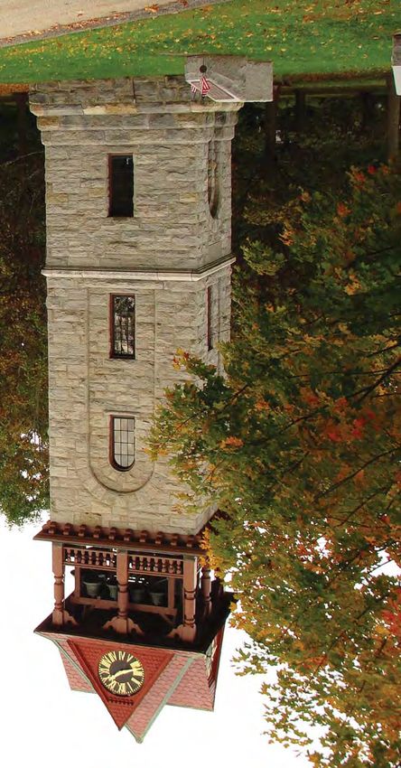
Stockbridge Chime Tower - Courtesy Diane Cote
In Partnership with
National Park Service
A Guide To                                                          42

Heritage Walks                                      7, 45, 54, 78
                                                                            19
Locations

                                       16, 28, 43
                                                                                       29, 33

                                                                         34, 39, 56,
                               31, 41, 58,
                                                                           72, 81
                               67, 79, 82
                                                                                           2, 38, 48

                        3, 11,
                      21, 23, 40,
                        57, 60
                                                                                                 4, 35, 62

             18, 49, 55

                                                                                                     68

               1,
           8, 13, 14,
        17, 26, 27, 36,
        44, 52, 63, 69.
          71, 76, 80,
               85                                                                                22, 65, 75

                          61, 84

                                                                                                 12, 73, 77
           10, 50

                                                                                            25, 47, 51, 86
            15, 24, 46,
              53, 83

                                                                                 6, 9, 30, 32,
                                                                                  37, 59, 64

                  5, 66, 74
                                                                         20

                                                                    70
Dan Raymond House / Sheffield Historical Society - by Dan Bolognani                                               Keystone Arches - by Diane Cote

       SATURDAY - SEPTEMBER 4, 2021                                             To register - email: Pepawhite@aol.com or 413-822-6566

            Labor Day Weekend                                                   Driving south on Rte 8 through Hinsdale, drive thru the traffic light,
                                                                                to the Hinsdale Town Hall, 39 South St., Hinsdale.
1 - Sheffield, MA 9 AM - 5 PM                                                   GPS 42.43767, -73.12283
SELF-GUIDED WALK: IF THIS HOUSE COULD TALK
                                                                                3 - Gt. Barrington, MA 10 AM - 12 NOON
This self-guided walking tour can be taken at your convenience.                 GREAT BARRINGTON'S ARCHITECTURE & HISTORY – THE
Pick up a tour booklet on the steps of the Old Stone Store or go to-            STORY OF GREAT BUILDINGS IN A GREAT TOWN
-ifthishousecouldtalk.weebly.com for a virtual version. The tour tells
the history of eleven buildings on                                              This walking tour with Nicholas Greene, from Clark & Green
the Sheffield Green, and the                                                    Architecture & Design, will lead partici-
people who lived, worked &                                                      pants on a stroll through historic downtown
worshipped in them.                                                             Great Barrington as they discover the rich
                                                                                history of the town's former and current
Many of the buildings date to the                                               inhabitants, their lives and the beautiful
18th & early 19th centuries. The                                                architecture they called home. Limited to
tour takes around 40 minutes and                                                10 participants. 2 hours - 2.5 miles
                                      Old Stone Store - by Dan Bolognani
is around one mile in distance,
most of which is on sidewalks and flat terrain. Please view the                 To register - email: greenen23@gmail.com
buildings from the sidewalk and public areas of the Green. Scan
the QR codes in the tour booklet or follow along with the virtual               Meet at the small engraved stone                    Congregational Church
version on your phone for bonus content like historic photos.                   monument at the corner of Main and
                                                                                Castle Streets. GPS 42.19378, -73.36382
Tour booklets can be picked up at Sheffield Historical Society Old
Stone Store, 137 Main St./Rt.7, next to the Mobil Station. Park in              4 - Becket, MA 10:30 AM - 2 PM
the town parking lot behind the gas station.                                    HISTORY HIKE TO THE KEYSTONE ARCHES RAILROAD
GPS 42.110729, -73.353073                                                       BRIDGES: A MOST MAGNIFICENT ENGINEERING FEAT BUILT IN
                                                                                THE 1840'S!
2 - Hinsdale, MA 10 AM - 12 NOON
MIGRATING TO THE HOUSATONIC RIVER HEADWATERS: AN                                Join Dave Pierce, from the Friends of the Keystone Arches, for a
INDOOR SLIDE PRESENTATION                                                       hike to the first cluster of stone arch railway bridges, the first cluster
                                                                                ever built in America, in 1840, and recently designated as a
Enjoy an indoor powerpoint presentation by Peter White, as you                  National Historic Landmark. They are impressive, breath-taking
will learn the history of Hinsdale’s migrating town centers and the             stone structures, 70 feet high, brilliantly revealing their ancestry in
eventual use of the Housatonic River in Hinsdale. Hear about the                the great cathedrals of ancient Rome! After the hike, you may tour
large, successful Hinsdale Woolen Mill and other mills and the                  the Chester RR Station Museum. Donations to the museum are
dams that powered the saw mill and grist mill on the river and the              accepted. 3.5 hours - 5 miles
development of the town center after the railroad came through.
2 hours                                                                         To register - email: dpiercedlp@aol.com or 413-354-7752
Beckley Furnace                                           Canoe Meadows Wildlife Sanctuary

From junction of Rts 20 & 102 in Lee, take Rt 20 east and drive 18       During the American Revolution, CT-forged iron helped fuel the
miles to Chester center. Meet at the Chester Railway Museum, 10          manufacture of American weaponry, most notably the cannons
Prospect St. We will carpool 2 miles to the trailhead.                   used by the Continental Army, Union weapons for the Civil War,
GPS 42.28054, -72.97860                                                  and railroad car wheels. Tour begins when you arrive.
                                                                         1 hour - 0.4 mile
5 - Kent, CT 12:30 PM - 2:30 PM
INDUSTRIAL IRON HERITAGE HIKE                                            140 Lower Road, East Canaan, just off US Rtes 44 & 7. If coming
                                                                         from the East, North, or West, take Route 44 to East Canaan, CT.
A special iron heritage hike in Macedonia Park, offered in memory        At the Congregational church, turn South onto Lower Road,
of Ed Kirby and Ron Jones. Join Marge Smith, of the Kent Historical      passing alongside the Church building, and continue for 1/2 mile,
Society, on a hike to learn about Kent’s iron industry and look for      turning to the right and down the hill.
evidence of charcoal makers
in the woods, including a                                                The former furnace office and the furnace stack are visible on your
rare mysterious structure.                                               left. If coming from the South, take Rte 7 to Canaan, CT. Pass a
Moderate difficulty. Optional                                            railroad yard on your left, and just before you cross a bridge across
visit to the old iron furnace                                            the Blackberry River, turn right into Lower Road, heading East. The
ruins at the end of hike.                                                Furnace is about 3 miles east of the intersection of Lower Road and
2 hours - 2.5 miles                                                      East Canaan. GPS 42.01274, -73.29074

Registration is Required.                  Old Iron Furnace - Kent, CT   7 - Pittsfield, MA 1 PM - 3 PM
Limit is 10 people. Email:                                               A WALK IN THE WOODS AT CANOE MEADOWS
curator@kenthistoricalsociety.org                                        WILDLIFE PRESERVE

From the center of Kent, drive west on Rte 341 for 1.7 miles, then       Join Deena Gilbert, from the Berkshire County Hiking Group, for a
turn right on Macedonia Brook Rd. Drive 1.6 mile into the Park, to       walk through this wildlife sanctuary, owned by Mass Audubon,
the parking area just over a bridge. Some parking available on the       which brings wilderness to
left before the bridge. GPS 41.74272, -73.49939                          Berkshire County’s largest city.
                                                                         Flat trails wind through the
6 - East Canaan, CT 10 AM - 2 PM                                         sanctuary’s scenic woods, fields,
TOUR THE BECKLEY BLAST FURNACE, CT'S DEDICATED IRON                      and wetlands, and along the
INDUSTRIAL MONUMENT                                                      edge of the Housatonic River.
                                                                         Sixty acres of open fields
Learn about the historic iron industry of the Upper Housatonic           provides critical breeding habitat
Valley, by the Friends of Beckley Furnace. Built in 1847, the            for grassland birds. No dogs,
furnace produced high quality iron until 1918, and is one of the         please. 2 hours - 3 miles                            Canoe Meadows
last surviving examples of the 19th and early 20th century blast
furnaces that were once commonplace CT sights, and is listed on          From Rte 7/20 in Lenox, 0.5 mile south of Guidos Market, take
the National Register of Historic Places. There were 21 furnaces in      Holmes Road at traffic light (by Family Footwear), and proceed 2.7
northwestern CT, as rich veins of iron ore were discovered in the        miles to sanctuary entrance on the right.
hills near the town of Salisbury.                                        GPS 42.445030, -73.252800
Photo courtesy of Adamah Farm                            Pfeiffer Arboretum by Great Barrington Land Trust

         SUNDAY - SEPTEMBER 5, 2021                                          From the Rt 7 & Rt 112 junction in Falls Village - Drive west on Rt
                                                                             112 to Dugway Road (opposite the Outfield Entrance to Lime Rock
            Labor Day Weekend                                                Park), turn right and follow Dugway Rd. for 2 miles. At iron bridge,
                                                                             turn left, then immediately turn right onto Housatonic River Rd.
8 - Sheffield, MA 9 AM - 5 PM                                                Drive 0.5 mile to parking lot for Falls Village dam boat launch. OR
SELF-GUIDED WALK: IF THIS HOUSE COULD TALK                                   from Rt 44 or Rt 41 - Drive east on Rt 112 until you reach the
                                                                             outfield entrance to Lime Rock Park, then turn left onto Dugway
REFER TO WALK # 1 FOR FULL DETAILS                                           Road and follow the above highlighted directions.
                                                                             GPS 41.96389, -73.37200
9 - Falls Village, CT 10 AM - 11 AM
ANCESTORS TO DESCENDANTS: AN ADAMAH FARM WALK                                11 - Gt. Barrington, MA 1 PM - 2:30 PM
                                                                             EXPLORE THE PERENNIAL PLANTS OF THE
Join Janna Siller for this walking tour of Adamah Farm, a certified          PFEIFFER ARBORETUM
organic farm located at the Isabella Freedman Jewish Retreat
Center, where we grow produce using regenerative practices. As               Join Devan Arnold, from the Gt. Barrington Agricultural
we wander through the perennial food forest, no-till fields, and             Commission, for a guided exploration of the many fascinating and
compost and chicken yard, we'll explore how Adamah Farm honors               charming perennial plants that make their home within the Pfeiffer
our ancestors with our descendants in mind. 1 hour, < 0.5 mile               Arboretum. Participants will be introduced to a diversity of local
To register, email: carly.sugar@hazon.org                                    plant species, from tall and mighty canopy trees, to low, creeping
                                                                             ground-covers, and all manner of floral friends in between.
On Rt 7 or on Rt 126, about 2 miles south of the center of Falls             1.5 hours - 0.7 mile
Village, Adamah Farm is located on the corner of Beebe Hill and
Johnson Rds. We will meet at the gate on that corner, with street            Meet at 249 Long Pond Road. From the center of Gt.Barrington,
parking on Beebee Hill Rd. GPS 41.940141, -73.347176                         head north and follow signs to RT 41. Proceed onto RT 41 and
                                                                             make a left turn onto Christian Hill Road. Follow Christian Hill Rd.
10 - Salisbury, CT 11 AM - 12 NOON                                           until Division St. (to where Christian Hill Rd, at the blinking red
CANNON AT 20 PACES! THE RISE AND FALL OF THE AMES                            light at Division St, becomes Long Pond Road). Continue 0.6 mile
IRON WORKS                                                                   from the blinking light. Look for the Pfeiffer Arboretum sign and
                                                                             trailhead on the left. GPS 42.235153, -73.386493
Contrast a shaded walk along a flat trail beside the Housatonic
River with the smoky history of the                                          12 - New Marlborough/Monterey, MA 1 PM - 3:30 PM
same land. Lou Bucceri, from the                                             A WOODLAND HIKE FROM GOULD FARM TO THE BERKSHIRE
Salisbury Association Historical                                             NATIONAL FISH HATCHERY
Society, will share the history about
the factory and the people that                                              Learn about Gould Farm’s history, mission, and connection to the
produced the most powerful can-                                              land as you begin your walk along the forested trails with Liz
non of the Civil War. Learn how the                                          Halla-Mattingly and Bob Rausch. The second half of the walk will
                                           Ames Iron Works - Falls Village
cannon destroyed no Confederate                                              be led by Joseph Xamountry from the Berkshire National Fish
targets, but only the man and company who created it.                        Hatchery, who will take you on a tour of the historic property,
1 hour - 1/2 mile                                                            where, for over a century, hundreds of thousands of fish have been
                                                                             cultured in a pristine aquifer that supplies a system of beautiful,
Berkshire Fish Hatchery - by Diane Cote                                                   Hancock Shaker Village

natural pools with 200 gallons of water per minute. Van service                      MONDAY - SEPTEMBER 6, 2021
back to Gould Farm will be provided. Rain or shine.
2.5 hours - 3 miles                                                                     Labor Day Weekend
From Rt 102 in Lee, at the traffic light at Big Y - take Tyringham Rd         14 - Sheffield, MA 9 AM - 5 PM
and drive 5.5 miles south, then turn right on to Monterey Rd and              SELF-GUIDED WALK: IF THIS HOUSE COULD TALK
drive 4 miles to Rt 23 in Monterey center. At Rt 23, turn right, and
drive 2 miles, then turn left onto Curtis Rd and drive 0.5 mile to            REFER TO WALK # 1 FOR FULL DETAILS
Gould Rd. Turn left and continue to the 2nd driveway, to the
Harvest Barn OR From the traffic light junction of Rts 7 & 23 in              15 - Sharon, CT 10 AM - 12 NOON
Gt. Barrington - Take Rt 23 east and drive 6.2 miles and turn right           HIKE AT THE GARRETT GOODBODY PRESERVE
onto Curtis Rd and drive 0.5 mile to Gould Rd, then turn left and
continue to the 2nd driveway, to the Harvest Barn.                            Join the Sharon Land Trust for this hike, situated on the southern
GPS 42.17477, -73.24111                                                       end of Indian Mountain, offering spectacular views of the Sharon
                                                                              Valley and Indian Lake. The trail gains elevation to 1,065 feet.
13 - Sheffield, MA 1:30 PM - 4 PM                                             Take a deep breath and enjoy the view - the lands that are seen
WALK THE SHAYS REBELLION SECTION OF THE APPALACHIAN                           here are almost all preserved, by the Sharon Land Trust or other
TRAIL                                                                         conservation organizations. The walk is very steep in spots,
                                                                              for intermediate / advanced walkers. 2 hours - 2.5 miles
Learn about the Appalachian
Trail, the most famous hiking                                                 Meet at the parking area located on
trail in the US, and Shays’                                                   Millerton Road (Rt 361), 0.6 mile south of
Rebellion in 1787 that may                                                    Dakin Road. It is a short but steep
have had some influence on                                                    driveway to a small parking area in the
the US Constitution. Bess                                                     field. GPS 41.904849, -73.491425                    Goodbody Preserve
Dillman, from the
Appalachian Mt. Club, will                                                    16 - Pittsfield, MA 10 AM - 11:30 AM
lead us through fields,                                                       GEOLOGY WALK AT HANCOCK SHAKER VILLAGE
hardwood forests and across                 Photo courtesy of Diane Cote
a boardwalk in a wetland.                                                     Spend an afternoon with staff exploring the rocks and landforms
The trail is uneven with roots and rocks, but a lovely walk through           around historic Hancock Shaker Village and its Farm & Forest Trail,
a variety of habitats. 2.5 hours - 4 miles                                    looking for evidence of glaciation, quarries, fossils, and other
                                                                              secrets of the earth. NOTE: This walk doesn’t include general
To register - email: elizabeth.dillman@gmail.com                              admission to the Village, which can be purchased after the free
                                                                              Heritage Walk. 1.5 hours - approx. 2 miles.
Appalachian Trail parking area is across the road from 1024                   To register - 413-443-0188 x-0 or info@hancockshakervillage.org
Sheffield/Egremont Rd., Sheffield. From Big Y in Great Barrington,
drive 2.2 miles south on Rte 7 to a right on Lime Kiln Road. Drive            Meet at the HSV Visitor Center/ticket desk, main entrance, on Rt
one mile and turn right on Sheffield/Egremont Road. The                       20 (34 Lebanon Mt. Road), Pittsfield/Hancock. From the junction
monument is immediately on the right and parking area is on the               of Rt 41 & Rt 20 junction- drive west on Rt 20 for 1/2 mile to the
left. GPS 42.1468, -73.3859                                                   HSV entrance. GPS 42.43091, -73.34049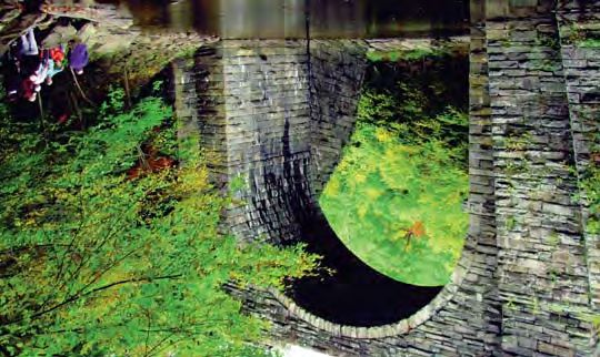
April Hill Conservation and Education Center - by Diane Cote                                 Colonial Warren - by Warren Historical Society

      SATURDAY - SEPTEMBER 11, 2021                                              Foundation). 2 hours - 1.5 miles

                                                                                 Registration is Required, email: aimee@gaiaroots.com.
17 - Sheffield, MA 9 AM - 5 PM
                                                                                 Visit: http://www.tamarackhollownatureanculturalcenter.org
SELF-GUIDED WALK: IF THIS HOUSE COULD TALK
                                                                                 The hike will begin at the Boulders southern trailhead starting in
REFER TO WALK # 1 FOR FULL DETAILS
                                                                                 Pittsfield. The parking area is at the intersection of Hubbard
                                                                                 Avenue and Dalton Avenue (Rt 8/9) at the traffic lights. This is a
18 - So. Egremont, MA 10 AM - 11:30 AM
                                                                                 busy intersection, so please take caution when entering the parking
EXPLORE THE 1744 HISTORIC GROUNDS AND FARM OF APRIL
                                                                                 area. GPS 42.470035, -73.1950714
HILL
                                                                                 20 - Warren, CT 10 AM - 12 NOON
Join Will Conklin, from the Greenagers, for an easy walking tour of
                                                                                 HISTORY MYSTERY: A HOMESTEAD IN WARREN
the 1744 historic house and the 100-acre property of April Hill
Conservation and Education Center (the former Kellogg
                                                                                 Historians are like detectives, uncovering clues and putting puzzle
Conservation Center). 1.5 hours - < 1 mile
                                                                                 pieces together to reconstruct life in the past; but sometimes they
To register - email: director@greenagers.org or 413-644-9090
                                                                                 encounter a “cold case.” Visit a secluded private property with
                                                                                 fascinating historic and natural features, and follow a discontinued
Meet at 62 Undermountain Rd., (Rt 41) So. Egremont, MA. From
                                                                                 roadbed to explore a pristine Early American homesite. We’ll share
the north: while driving on Rt 23 through the center of So.
                                                                                 what years of research has revealed about the original homesteader
Egremont, MA, at the junction of Rt 23 & 41, turn onto Rt 41 and
                                                                                 and what this little piece of Warren tells us about the changing face
drive 1 mile. From the south: from Salisbury, CT, drive 12 miles on
                                                                                 of this area. The walk is offered by the Warren Historical Society
Rt 41. GPS 42.15456, -73.42070
                                                                                 and the Warren Land Trust, along with CT State Archaeologist
                                                                                 Susan Sportman. 2 hours - 3 miles
19 - Pittsfield/Dalton, MA 10 AM - 12 NOON
EXPLORE THE FAUNA AND FLORA OF "THE BOULDERS"
                                                                                 To register - warrenhistorian@outlook.com or 860-503-8545
PRESERVE
                                                                                 From the center of Warren (stoplight at the intersection of Rts. 45
Learn about the plants, trees, wild edibles, tracks and signs of
                                                                                 and 341 and Sackett Hill Road, continue on Rt. 45 toward
wildlife on this hike at the
                                                                                 Cornwall. Right turn onto Melius Road. Left at the “T” to continue
Boulders, a Berkshire
                                                                                 on Melius Road. Signs will direct you further from 164 Melius
Natural Resources Council
                                                                                 Road. GPS 41.73115, -73.38395
preserve, led by naturalist
Aimee Gelinas, from
                                                                                 21 - Gt. Barrington, MA 10 AM - 12 NOON
Tamarack Hollow Nature
                                                                                 GREAT BARRINGTON'S ARCHITECTURE & HISTORY – THE
and Cultural Center. Hike
                                                                                 STORY OF GREAT BUILDINGS IN A GREAT TOWN
is free (donations accepted
for the center). Program is
                                                                                 REFER TO WALK # 3 FOR FULL DETAILS
co-sponsored by the
Berkshire Natural                                  The Boulders Preserve
Resources Council, the Dalton Cultural Council and the Berkshire
Environmental Endowment Fund (Berkshire Taconic Community
Royal Hemlock Trail - by Lauren Stevens                                        Sharon Town Green - by Dan Bolognani

22 - Monterey, MA 10 AM - 1 PM                                                Road/Rt 183 junction. Driving on Rt 7, at the junction of Rts 7 &
ROYAL HEMLOCK TRAIL                                                           183 at the north end of Gt. Barrington, drive north on Rt 183 for
HIKE IN THE STEPS OF THE EARLY SETTLERS                                       0.8 mile.

A walk on the Bidwell House Museum grounds as well as the                     24 - Sharon, CT 12 NOON - 1 PM
BNRC's Hudson-Howard property, this hike traces the route of the              THE SHARON GREEN: LIVING MEMORIES
early settlers of Township No. 1 from their homes to the 1st
meeting house on a hill near the Museum. Richard Greene will                  Join the Sharon Historical Society staff on a stroll around the
lead the group on the old roadways, past foundations and stone                Sharon Green, which is a public space surrounded by buildings
walls of long-ago homesteads, and explore flora and fauna along               which have served as meeting houses and churches, some of which
the way. Terrain is steep and rocky in a few places. NOTE- Does               date from the 18th century. 1 hour - 1.5 miles
not include a tour of the museum interior. An inside tour can be
arranged after the free Heritage Walk. 3 hours - 4 miles                      To register - email: director@sharonhist.org OR 860-364-5688

To register via the website - www.bidwellhousemuseum.org                      The Sharon Historical Society & Museum is located at 18 Main
                                                                              St./Rt 41. Traveling from the south, either take Rt 22 in NY to Rt
From Monterey center - take Tyringham Rd. for 1.5 miles, and                  343 in Connecticut or take Rt 7 to Rt 4 in Conn. From the
take a left onto Art School Rd. and drive 1 mile to the end; OR               northwest, take Rt 22, enter Millerton, NY and take a right at the
From the traffic light at Big Y in Lee - take Tyringham Rd and drive          second stoplight, to Rt 361/Sharon Road. Follow Rt 361 until you
5.5 miles, take a right onto Monterey Rd and drive for 2.3 miles,             reach Rt 41. Coming from the north east & Massachusetts, take Rt
then take a right on Art School Rd. and drive 1 mile to the end at            41. GPS 41.87976, -73.47678
the Bidwell House Museum. GPS 42.20888, -73.21830
                                                                              25 - Norfolk, CT 1 PM - 2 PM
23 - Gt. Barrington, MA 10 AM - 1 PM                                          A WALKING TOUR OF BARBOUR WOODS
GEOLOGY OF THE SOUTHERN BERKSHIRES: HIKE THROUGH A
FOREST OF GIANT GLACIAL-BOULDERS TO PANORAMIC                                 Join forrester, Star Childs,
SUMMIT VISTA AT FLAG ROCK                                                     on a walk through the
                                                                              Norfolk Land Trust’s
Join Mike Bergman, professor of earth sciences at Bard College at             Barbour Woods.
Simon's Rock for a hike and Berkshires geology lesson through this
forested tract of land on the western side of Monument Mountain,              No ordinary walk in the
through a remarkable giant                                                    woods, as he will talk about
boulder field to an outstanding                                               the natural surroundings
panoramic view. Rain cancel                                                   and illuminate what sort of
                                                                                                                                   Barbour Woods Trail
date on Sept 18.                                                              activities occurred to shape
3 hours - 3.5 miles                                                           the forest. 1 hour - 1 mile
To register - email
bergman@simons-rock.edu                                                       From Rt 44 in Norfolk, turn onto Maple Ave. and continue straight
                                                                              until it turns into Lovers Lane and a dirt road. The trailhead is here.
Meet at side of road 0.2 mile                                                 GPS 42.004724, -73.18853
north of Taft's Farm at Division              Flag Rock - by Christy Butler
Ashley Falls - by Fred Harwood                                                   Tamarack Hollow Preserve

26 - Ashley Falls, MA 2 PM - 3 PM                                              Participants limited to 12, and will be required to sign a liability
A GUIDED WALK AROUND HISTORIC ASHLEY FALLS                                     release at start of hike. 3 hours - 3 miles

Catherine Miller, from the Sheffield Historical Society, will lead this        Registration is Required - email: kcoyross@aol.com
tour around the Ashley Falls Village Green. Named for the Ashley
family who were one of its first settlers, the village has played an           From Pittsfield take Rt. 20 west beyond Hancock Shaker Village
important role in the history of Sheffield from its founding. It is the        and continue 0.5 mile to the top of Lebanon Mountain. Before the
location where the Sheffield Resolves, the precursor to the                    descent begins down the mountain, pull into the large pullover
Declaration of Independence, was written and where Mum Bett                    parking area on the right. The trailhead begins in the break in the
lived as a slave. 1 hour - 1 mile Rain date on 9/12                            fence.

To register - sheffieldhistoricalsociety@gmail.com or 413-229-2694             29 - Windsor/Savoy, MA 10 AM - 12 PM
                                                                               HIGH ELEVATION BOREAL SPRUCE-FIR FOREST: PLANT, TREE
Meet in front of the Ashley Falls Post Office, at 1180 Ashley Falls            AND WILD EDIBLE HIKE AT THE TAMARACK HOLLOW NATURE
Rd./Rt. 7A . From points north and south, take Rt. 7 until you reach           & CULTURAL CENTER
Rt. 7A/Ashley Falls Rd. Follow 7A until you reach the Post Office,
behind which is a lot where you can park.                                      Join naturalist Aimee Gelinas, from Tamarack Hollow Nature and
GPS 42.0563, -73.33561                                                         Cultural Center, for this hike featuring the unique high elevation
                                                                               flora of the boreal forest (located in the headwaters area of the
        SUNDAY - SEPTEMBER 12, 2021                                            Housatonic River) including tips for tree, plant and wild edible
                                                                               identification. Hike is free (donations accepted for the nature
                                                                               center). Supported by the Berkshire Taconic Central Berkshire
27 - Sheffield, MA 9 AM - 5 PM
                                                                               Fund. 2 hours - 1.5 miles
SELF-GUIDED WALK: IF THIS HOUSE COULD TALK
                                                                               Registration required - email: aimee@gaiaroots.com
REFER TO WALK # 1 FOR FULL DETAILS
                                                                               Please do not use a GPS to locate us on Savoy Hollow Road.
28 - Hancock, MA 9:30 AM - 12:30 PM
                                                                               Tamarack Hollow Nature & Cultural Center, 1515 & 1516 Savoy
HIKE THE TACONIC CREST TRAIL - FROM LEBANON MT.
                                                                               Hollow Rd, Windsor, MA. Only enter Savoy Hollow Road via
ROAD/RT 20 TO TWIN PONDS, PITTSFIELD STATE FOREST
                                                                               Griffin Hill Rd off Route 116 in Savoy, MA (you can use a GPS to
                                                                               find Griffin Hill Rd). From Rt 9, in Windsor center take 8A north to
Hike from the southern terminus of the 37-mile long Taconic Crest
                                                                               Rt 116 in Savoy. At end of Rt 8A take a right onto Route 116
Trail to Twin Ponds in Pittsfield
                                                                               heading towards Savoy Center and Plainfield. Go approx 1.1 miles
State Forest, one of the many
                                                                               through the center of Savoy and take your first right after the
reservoirs built by the Shakers.
                                                                               center of town onto River Rd (there is a small light brown house
This is a ridge walk through a
                                                                               with cream trim on the corner, this is #4 River Road). After the
hemlock and hardwood forest
                                                                               small house, cross the bridge over the river and go immediately to
with some short steeper
                                                                               your right up the hill - this is Griffin Hill Rd (there is a sign saying
sections. Learn about the
                                                                               "Tamarack Hollow-1 mile”). Continue up Griffin Hill Road (which
Taconic Hiking Club and why
                                                       Taconic Crest Trail     will become Savoy Hollow Rd) for approx. 1 mile until you reach
the Taconic region and this trail
                                                                               Tamarack Hollow.
are so important to efforts to preserve larger, intact forested areas.
West Cornwall - by Dan Bolognani                                              Notchview Farm - by Donna Drew

30 - Falls Village, CT 10 AM - 12 NOON                                         American Chestnut Foundation's efforts to
15-MILE SCENIC BIKE RIDE FROM WEST CORNWALL TO FALLS                           restore this iconic tree to our landscapes.
VILLAGE AND RETURN                                                             Rain cancels. 1 hour -
Edith Wharton’s The Mount - by Diane Cote                               South Canaan Meeting House - by Dan Bolognani

34 - Lenox, MA 3 PM - 4:30 PM                                                    SATURDAY - SEPTEMBER 18, 2021
EXPLORE THE IMPRESSIVE GARDENS & LANDSCAPE OF THE
MOUNT - HOME OF EDITH WHARTON
                                                                           36 - Sheffield, MA 9 AM - 5 PM
                                                                           SELF-GUIDED WALK: IF THIS HOUSE COULD TALK
Anne Schuyler will guide you on an exploration of the impressive
gardens and woodland trails of The Mount-Edith Wharton's Estate,
                                                                           REFER TO WALK # 1 FOR FULL DETAILS
a 1902 home (a National Historic Landmark) of Pulitzer Prize
winning author Edith Wharton. NOTE: Does not include an interior
                                                                           37 - Falls Village, CT 9 AM - 3 PM
house tour, which, for a fee, can be arranged before the free
                                                                           SELF-TOUR OF THE FALLS VILLAGE MEETINGHOUSE
Heritage Walk. 1.5 hours -
Lenox Town Hall - by Wendy Ames Mount Greylock
To register - email: dpiercedlp@aol.com or 413-354-7752 trail that respects nature and reveals the river's beauty. Learn of the
historic, cultural and ecological significance of the river.
From the junction of Rt 102 & Rt 20 in Lee - Drive 7 miles east 1 hour - 0.5 mile.
on Rt 20 to West Becket, to the junction where Rt 8 splits. Turn left
onto Rt 20-east/Rt 8-north. Drive for 5 miles, and at the bottom of To register - email: Elia@greenagers.org or 413-429-6416
a long hill, take a left turn onto Rt 8-north. Drive 10 miles to the
Washington Town Hall and take a right turn onto Summit Hill Rd. Meet at the Du Bois River Garden Park at Church St. & River St.
Shortly, you will reach a narrow bridge over the railroad tracks- The River Walk is located in the heart of Great Barrington. Parking
park along here. OR FROM DALTON - follow Rt 8 south (approx. is located off of Rt 7, on Bridge St., behind the Searles Bryant
9 miles) and turn left onto Summit Hill Rd. in Washington. Within building (across the street from Memorial Field and the Gt.
a short distance, you will reach a narrow bridge over the railroad Barrington Coop). GPS 42.19375, -73.35923
tracks- park along here. Please don't park along Summit Hill Rd.
past the bridge. GPS 42.37490, -73.11129 41 - Stockbridge, MA 10 AM - 12 NOON
HISTORICAL WALKING TOUR OF STOCKBRIDGE, MA
39 - Lenox, MA 10 AM - 11 AM
HISTORIC LENOX VILLAGE WALKING TOUR - VISUALIZING 250 Join Bess Dillman, from Berkshire Hiker,
YEARS OF HISTORY for a history tour of Stockbridge - from
the first residents, to the missionary
Lenox Village has a history ranging from the Revolutionary era to settlement, to Elizabeth Freeman (Mum
mid-19th century shire town to the Gilded Age Cottager Era. Join Bett), to writer Catherine Sedgwick, to
Lucy Kennedy, from the Lenox Historical Commission, for this walk Norman Rockwell and more.
to gain an appreciation of the breadth of the history of this little Stockbridge has a colorful history! We
village. 1 hour - 0.5 mile will walk along the streets and into the
cemetery. 2 hours - 1.5 miles
Meet at the Lenox Historical Society at 65 Main St. - across from
the shopping plaza & Neijaimes Liquor Store. Parking is available To register, as participation is limited to
By Diane Cote
behind the bank next door. GPS 42.3565, -73.2848 15, email: elizabeth.dillman@gmail.com
40 - Gt. Barrington, MA 10 AM - 11 AM Meet at the Stockbridge Congregational Church parking lot, 44
AN INTERPRETIVE STROLL ON THE HOUSATONIC RIVER WALK Main St., Stockbridge. GPS 42.28830, -73.31949
- BERKSHIRES' NATIONAL RECREATION TRAIL
42 - Lanesborough, MA 1 PM - 3 PM
Enjoy a narrated tour offered by THE HISTORY AND NATURE OF MT. GREYLOCK'S SUMMIT:
the Gt. Barrington Land A MOUNTAINTOP WALK
Conservancy of this designated
National Recreation Trail that Join Mike Whalen, from the Mass. Dept. of Conservation and
follows the Housatonic River as Recreation, and Peter Dudek, from Bascom Lodge, atop the most
it flows behind Main St. scenic, highest elevation (3,491') and oldest wilderness state park in
Incredible volunteer efforts Massachusetts. Discover the 1930's period of great park building
removed 400 tons of debris when government work programs like the CCC-Civilian
from the river and developed a Great Barrington Riverwalk
Conservation Corps created special places for recreation.Hancock Shaker Village Civilian Conservation Corps - By Mass DCR
The rustic, yet elegant, "parkitecture" of Bascom Lodge became a SUNDAY - SEPTEMBER 19, 2021
distinctive style that defined America's parks. This is an interpretive
walk around the summit of Mount Greylock, with an emphasis on
44 - Sheffield, MA 9 AM - 5 PM
its unique ecology and historic structures as they comprise a fully
SELF-GUIDED WALK: IF THIS HOUSE COULD TALK
realized historic landscape; and take an insider's tour of Bascom
Lodge. NOTE - Summit Parking Fee is $5 for Mass. plates, $6 for
REFER TO WALK # 1 FOR FULL DETAILS
non-Mass. plates. 2 hours - 0.25 mile
45 - Pittsfield, MA 10 AM - 12 NOON
To register - email: hikewithmike@live.com
THE CIVILIAN CONSERVATION CORPS (CCC) AT PITTSFIELD
STATE FOREST
Meet on the summit of Mt. Greylock in front of Bascom Lodge.
Access to the reservation is from Rockwell Rd., off Rt 7 in
Join the Mass. Dept. of Conservation & Recreation (DCR) to
Lanesborough or from Notch Rd. in No. Adams.
explore a landscape shaped by the CCC. This New Deal program
GPS 42.636875, -73.16692
during the 1930's Great Depression improved our public parks and
forests nationwide. The program inspired a recreational heritage
43 - Hancock/Pittsfield, MA 1 PM - 4 PM
that we still enjoy today. Join Bob Rando for a tour of forgotten
HISTORY WALK ON THE HANCOCK SHAKER VILLAGE
Pittsfield State Forest recreation features built by the CCC some 80
"SHAKER TRAIL"
years ago, including the famous Ghost and Shadow Ski Trails. Visit
the rustic Ski Lodge, still in use. 1.5 hours - 1.5 miles
Hike the Shaker Trail, with HSV staff, located across Rt 20 from
Hancock Shaker Village, to the HSV North Family Site and to
Pittsfield State Forest – 1041 Cascade St., off of West St. From the
Mount Sinai, a spiritual “feast ground” for the Shaker community.
park entrance, drive another 0.7 mile (Shamrock Boulevard) to the
Hike will include stops at remains of mill sites, of the North Family
meeting place at Lulu Cascade day-use area parking lot.
dwelling site (active from 1821-1867), and the summit of the
GPS 42.48543, -73.30101
mountain, where the Shakers held special celebratory services
twice a year in the mid-19th century. Moderate to strenuous hike.
46 - Sharon, CT 10 AM - 12 NOON
A MODERATE HIKE AT THE SKIFF MOUNTAIN NORTH
NOTE: This walk does not include general admission to the Village.
PRESERVE
For a fee, admission to the Village can be arranged before the free
Heritage Walk. 3 hours - 2.5 miles.
Join this hike with the Sharon Land
Trust on a 197-acre preserve located
To register - 413-443-0188 x-0 or
on the Kent/Sharon town border.
email: info@hancockshakervillage.org
The preserve is predominantly
forested and also encompasses
Meet at the HSV Visitor Center/ticket desk, main entrance, on Rt
several post agricultural fields and
20 (34 Lebanon Mt. Road), Pittsfield/Hancock. From the junction
extensive wetlands, which includes
of Rt 41 & Rt 20 junction - drive west on Rt 20 for 1/2 mile to the
a rare red spruce wetland by Sharon Land Trust
HSV entrance. GPS 42.43091, -73.34049
community, considered to be one of
CT's critical habitats. The preserve contains habitats which support
rare plants and wildlife species, as well as an impressive diversity of
breeding bird species. 2 hours - 1 mileMountain Express Trail - by Norfolk Rails To Trails Citizen Science with Greenagers - by Schoodic Institute
Parking and trailhead access are on Skiff Mountain Road, just Old Mill Trail and learn about the history of the water powered mill
inside the Kent border, past Marvelwood School and 1.3 miles operations, river ecology and current issues. This level trail
from its intersection with West Woods Road #1. connects the communities of Hinsdale and Dalton and follows the
GPS 41.80093, -73.46834 remnants of an early mill operation that once powered thriving
woolen mills. Participants can
47 - Norfolk, CT 10 AM - 12 NOON choose to turn around earlier, if a
THE MOUNTAIN EXPRESS RAILS TO TRAILS HIKE shorter length is desired.
2.5 hours - 3 miles
Nestled in the foothills of the Berkshire mountains, Norfolk's brief
but illustrious history of passenger trains (the Mountain Express) To register - email: adixon@hvato-
and rail freight comes roaring back to life with a historical hike day.org (note Old Mill Trail Hike in
along remnant sections of the railroad right-of-way in town. Join subject line) or call 413-298-7024.
the Rails to Trails organization for a Old Mill Trail - by Dennis Regan
hike at Station Place and progress From Route 8 in Hinsdale, turn
through the lands of the former Brown left, if heading south, or right, if heading north, on to Old Dalton
Company iron colliers, where the once Road. Cross over the river and take an immediate left into the
abandoned coal piles and antique trailhead parking. The Hinsdale Trading Company is almost directly
equipment have returned to opposite the trailhead. GPS 42.4480, -73.1305
woodlands.
49 - So. Egremont, MA 10 AM – 12 NOON
Continue on the old rail-bed, through OPERATION POLLINATION CITIZEN SCIENCE WALK WITH
the Wood Creek Flood Control area GREENAGERS
and cross over North Street, where a
rail bridge once stood, to end up on Join Greenagers' guides to learn about native bumblebee
the proposed North Brook Rail Trail pollinators in diverse habitats at the 100-acre property of the April
by Norfolk Rails To Trails
segment. View the challenges and Hill Education and Conservation Center. Inspired by the Egremont
remarkable skills presented by today's busy beaver engineers, who Pollinator Pathway toolkit designed by Evan Abramson and Dr.
have reclaimed a section of this historic rail line for themselves. Robert Gegear of Landscape Interactions and the Beecology
2 hours - 2 miles Project, participating citizen scientists will take photos/videos of
bee/plant interactions.
To register - email: michelleschilds56@gmail.com
or call 860-542-5953 The data collected will help develop more pollinator-friendly land
care practices and support regional efforts to conserve at-risk
Park and meet at Station Place in the Village Center. pollinator species. Easy level walking/hiking. Wear sturdy footwear.
GPS 41.990347, -73.19944 Bring water to drink. 2 hours -Colonial Theatre - Pittsfield, MA April Hill Conservation & Education Center - by Diane Cote
50 - Salisbury, CT 11 AM - 12 NOON SATURDAY - SEPTEMBER 25, 2021
CANNON AT 20 PACES! THE RISE AND FALL OF THE AMES
IRON WORKS
52 - Sheffield, MA 9 AM - 5 PM
SELF-GUIDED WALK: IF THIS HOUSE COULD TALK
REFER TO WALK # 10 FOR
FULL DETAILS
REFER TO WALK # 1 FOR FULL DETAILS
51 - Norfolk, CT 1 PM - 2 PM
53 - Sharon, CT 9 AM - 10 AM
JAMES MARS: A JOURNEY TO
THE SHARON GREEN: MAKING COMMUNITIES
FREEDOM Ames Iron Works
REFER TO WALK # 24 FOR FULL DETAILS
Born in 1790, James Mars was the last known slave sold in Norfolk
CT. Gaining his freedom at the age of twenty-one, his life journey is
54 - Pittsfield, MA 10 AM - 11 AM
a fascinating one. Deacon, activist for equal rights, and a
TOUR THE HISTORIC COLONIAL THEATRE
community leader.
Enjoy a journey with Bill Munn through the history of the gilded
Join the Norfolk Historical Society at
age Colonial Theatre, owned by The Berkshire Theatre Group, as
Norfolk’s Center Cemetery to learn more
you hear the story of the 1903 world-class theatre, movie house,
about this remarkable man, and the many
National Historic Treasure appointment by Hillary Clinton,
people who helped him along his journey.
restoration, and 2006 grand re-opening. 1 hour
1 hour.
To register - email: bmarshall@berkshiretheatre.org
Meet at the Center Cemetery, 15 Old Colony
or 413- 448-8084 ext. 18
Road, Norfolk CT 06058. From Rte 44 turn
North onto Rte 272, North Street. Old
Located at 111 South St., just north of the junction of Rts 7 & 20 in
Colony Road is your first left, please park
the center of Pittsfield. Wear sensible walking shoes for walking
along the south side of the road.
through 3 floor levels. We do have elevator access.
GPS 42.44622, -73.25402
Please Remember -
55 - So. Egremont, MA 10 AM - 11:30 AM
l Wear sturdy footwear for those ‘Walks’ that include EXPLORE THE 1744 HISTORIC GROUNDS AND FARM OF
trail hikes and outdoor trekking. APRIL HILL
l Bring a water bottle / beverage to stay hydrated.
l Bring insect repellent if REFER TO WALK # 18 FOR FULL DETAILS
you’re hiking outside.
56 - Lenox, MA 10 AM - 11 AM
l Read the Heritage Walks WALKING TOUR OF ELEGANT CLIFFWOOD STREET AND
description carefully - some YOKUN AVENUE
require pre-registration!
l Enjoy! Cliffwood Street and Yokun Avenue remain among the most
elegant streets in Lenox. Join Lucy Kennedy, from the LenoxYokun Ave, Lenox - by Lenox Historical Society Downtown Falls Village - photo by Dan Bolognani
Historical Commission, as she describes how these were the major To register - email: info@weststockbridgehistory.org
areas for "summer cottagers" and other wealthy 19th century
residents to build their summer homes. Hear the background on Meet at the cemetery on Rt 41, 1 mile north of the village center.
what remains, as well as what used to be. 1 hour - 0.5 mile GPS 42.34787,-73.37977
Meet at the Lenox Historical Society at 65 Main St. - across from 59 - Falls Village, CT 1 PM - 2:30 PM
the shopping plaza & Neijaimes Liquor Store. Parking is available WALKING TOUR OF DOWNTOWN FALLS VILLAGE
behind the next door bank. GPS 42.3565, -73.2848
Join a guided tour, by the Falls Village-Canaan Historical Society, of
57 - Gt. Barrington, MA 10 AM - 11 AM downtown Falls Village, a designated historic district. NOTE: Does
AN INTERPRETIVE STROLL ON THE HOUSATONIC RIVER WALK not include a tour of the museum interior. An inside tour, can be
- BERKSHIRES' NATIONAL RECREATION TRAIL arranged before or after the free Heritage Walk. 1 hour - 0.75 mile
Enjoy a narrated tour offered by the Gt. Barrington Land Meet at the Falls Village Depot at 44 Railroad Street, Falls Village.
Conservancy of this designated National Recreation Trail that GPS 41.953487, -73.364268
follows the Housatonic River as it flows behind Main St. Incredible
volunteer efforts removed 400 tons of debris 60 - Gt. Barrington, MA 1-2 PM & 2-3 PM
from the river and developed a trail that ENCOUNTERING W.E.B. DU BOIS - NATIONAL HISTORIC
respects nature and reveals the river's beauty. LANDMARK TOUR
Learn of the historic, cultural and ecological
significance of the river. 1 hour - 0.5 mile W.E.B. Du Bois, the great African-American author and civil rights
leader, was born and raised in Great Barrington and returned
To register - email: frequently. Join David Glassberg, from the Univ. of Massachusetts,
Elia@greenagers.org or 413-429-6416 for an interpretive tour on a
Housatonic River Walk level woods trail leading to
Meet at the Du Bois River Garden Park at the foundation of Du Bois's
Church St. & River St. The River Walk is located in the heart of boyhood home - a National
Great Barrington. Parking is located off of Rt 7, on Bridge St., Historic Landmark and the
behind the Searles Bryant building (across the street from Memorial first destination in the U.S. to
Field and the Gt. Barrington Coop). GPS 42.19375, -73.35923 tell the story of his life and
legacy.
58 - West Stockbridge, MA 10:30 AM - 12 NOON
TOURING THE NEIGHBORHOODS OF WEST STOCKBRIDGE: 1 hour -Mount Everett State Reservation Adamah Farm - by New York Times
61- Mount Washington, MA 2 PM - 4 PM SUNDAY - SEPTEMBER 26, 2021
THE VIEW FROM "THE DOME" - A HIKE AT MOUNT EVERETT
STATE RESERVATION
63 - Sheffield, MA 9 AM - 5 PM
SELF-GUIDED WALK: IF THIS HOUSE COULD TALK
The Dome, also known as Mount Everett, has figured prominently
both in the landscape and history of the southern Berkshires.
REFER TO WALK # 1 FOR FULL DETAILS
Notable scientists and luminaries have chronicled their impressions
of this place. Follow in their footsteps, as we ascend to the top of
64 - Falls Village, CT 10 AM - 11 AM
The Dome for a sweeping view of the Housatonic River Valley and
MEET THE GOATS AT ADAMAH FARM
into NY.
Which is the most fun, mischievous and friendliest farm animal?
Join Alec Gillman of Mass. Dept. of Conservation and Recreation
The humble goat! Join Carly Sugar on a walk to meet our herd at
for a rigorous hike up the Appalachian Trail to the summit of
Adamah Farm (part of the Isabella Freedman Center and Hazon)
Mount Everett (a 500 foot elevation gain over 0.7 mile). Along the
and learn about regenerative animal husbandry practices. Walk our
way we will dip into the past, recounting some of these colorful
pasture and find out how goats turn poison ivy into chevre!
stories, and allow for the opportunity to create your own
1 hour, < 0.5 mile
impressions of The Dome. 2 hours - 1.4 miles
To register, email carly.sugar@hazon.org
To register - email: alexander.gillman@mass.gov or 413-442-8928
x134
On Rt 7 or on Rt 126, about 2 miles south of the center of Falls
Village, turn onto Johnson Rd. and turn into the Isabella Freedman
Mount Everett State Reservation – On East Street, is 7.5 miles from
Jewish Retreat Center driveway and park in the large lot. We'll
the intersection of MA Rts 23 & 41 in South Egremont; or 5.4 miles
meet at the entrance to the parking lot.
from NY Route 22 in Copake, NY, via NY route 344. Look for the
State Reservation sign. Then follow the dirt Mount Everett Road for
65 - Monterey, MA 10 AM - 11:30 AM
2 miles uphill, past Guilder Pond, to the Appalachian Trail parking
"RE-FRAME THE OUTDOORS" THROUGH "KID-TINTED GLASSES"
lot. GPS 42.10653, -73.43657
AT THE BIDWELL HOUSE MUSEUM GROUNDS - A FAMILY HIKE
62 - Becket, MA 2 PM - 4 PM
Join this child-led walk with Taylor Staubach, from Berkshire Family
EXPLORING THE BECKET LAND TRUST'S HISTORIC QUARRY &
Hikes. Discover how to see things through "kid-tinted glasses". As
FOREST
parents, we want to help our children appreciate nature and
connect to it. More times than not, they don’t need our prompting.
REFER TO WALK # 35 FOR FULL
DETAILS
Often, it is the kids that help us connect to a part of nature that
we’ve lost as we age. Kids continually surprise us where their
From junction of Rts 20 & 102 in Lee,
thoughts lead. Some of these questions and our attempted answers
take Rt 20 east and drive about 14
Becket Quarry may inevitably lead us to revisiting things we haven’t thought about
miles, to the junction where Rt 8 turns
in a long time. Kids reframe the world for us, because of their
left off Rt 20 - here, you will turn right on Bonny Rigg Hill Rd.
ability to simultaneously see things in two ways, oscillating between
Drive about 2 miles and turn left on Quarry Rd. and drive for 1
big picture concepts to the minute details near-at-hand. It
mile, parking is on the right. GPS 42.25116, -73.02014
challenges us to explain things at their level of understanding; andCourtesy of Berkshire Family Hikes Photo courtesy of Diane Cote
while we’re worrying about covering ground,they’re uncovering 68 - Lee, MA 11 AM - 12 NOON
small wonders that we’ve overlooked. 1.5 hours, 1.5 miles. A NATURE WALKING TOUR AT GOLDEN HILL TOWN FOREST
To register - email: taylor@berkshirefamilyhikes.com
Join naturalist Linda Cysz, from the Lee Land Trust, for a
From Monterey center - take Tyringham Rd. for 1.5 miles, then left meandering walk through this town forest to get a sense of the
onto Art School Rd. and drive 1 mile to the end; OR From the natural setting and learn some of Lee's town history. Golden Hill
traffic light at Big Y in Lee - take Tyringham Rd and drive 5.5 miles, Town Forest's 70-acre property was once owned by George
take a right onto Monterey Rd and drive for 2.3 miles, then right Westinghouse as part of his estate known as Erskine Park. His
on Art School Rd. Drive 1 mile to the end at the Bidwell House house was in Lenox near Laurel Lake and his farmland extended
Museum. GPS 42.20888, -73.21830 across the road to the Golden Hill area. In 1939 George
Westinghouse, Jr. donated this parcel to the Town of Lee. Here is
66 - Kent, CT 10 AM - 12 NOON where you’ll find the highest peaks in Lee at about 1220’ elevation.
TREE IDENTIFICATION NATURE WALK AT POND MOUNTAIN
NATURAL AREA The Pinnacle has views to October Mt., Highlawn Farm and Laurel
Lake. This is truly an enchanted
Join Russell Plumb, an arborist from Sawing High Climbers, on a geologic world. Easy loop trails guide
hike as he provides tips and skills for identifying native trees, within you through the boulders, ledges,
this 800-acres that is highlighted by Fuller Pond. 2 hours - 1.5 wildflowers, mushrooms and old trees.
miles. To register - email: stevepener@pondmountaintrust.org In the early 1960’s this was a vibrant
OR 203-470-0393 picnic spot with pavilion, stone
fireplace and even electricity! Today,
From the village of Kent, take RT 341 West, take a right onto that area is the open field.
Macedonia Brook Road, and then a right onto Fuller Mt Rd. 1 hour - 1 mile
Parking area will be on the right at top of hill. Use 99 Fuller Mt Rd,
Kent, CT for GPS. GPS 41.7601, -73.4830 Heading north on Rt 20 from the
center of Lee, after crossing the
67 - Stockbridge, MA 10:30 AM - 12 NOON railroad tracks and the river, drive for
STOCKBRIDGE COMMUNITY BIKE RIDE - A LEISURELY 17-MILE 0.8 mile to Golden Hill Road (across
BICYCLE RIDE from the Retro Pop Shop). Turn right Golden Hill Town Forest
onto Golden Hill Road and drive uphill
Join Marie Raftery & Buck Smith, from the Stockbridge Bike Group, for 0.3 mile to a parking site on the right side of road, at Lee Town
for a supported bike ride on scenic roads, passing by the Berkshire Forest sign. GPS 42.322441, -73.255433
Botanical Garden and along the Housatonic River, through the
town of Housatonic and on to Taft Farm, a family farm with an 69 - Ashley Falls, MA 1 PM - 3:30 PM
acclaimed bakery. This is a ride for intermediate cyclists on public CANOE PADDLING TRIP ON THE HOUSATONIC RIVER FROM
roads with traffic. Helmets are required. 1.5 hours - 17 miles BARTHOLOMEW'S COBBLE
To register - email: kraftery@roadrunner.com or 413-298-4910
Paddle through farms and forest with an eye to the sky for migrat-
Parking and start at the Stockbridge Town Offices, 50 Main St. ing raptors as you wind your way down the Housatonic River. We
GPS 42.28153, -73.30911 will start and end at the same location. Suitable for families with
children 10+ years and older. Canoes, paddles and PFD’s arePhoto courtesy of Dennis Regan Wharton’s Woods - by The Mount
provided. People can register to bring their own canoe or kayak. SATURDAY - OCTOBER 2, 2021
Rain Date is Oct 3. 2.5 hours - 3 miles of paddling. Registration IS
REQUIRED - 413-298-7024 or email: adixon@hvatoday.org
71 - Sheffield, MA 9 AM - 5 PM
SELF-GUIDED WALK: IF THIS HOUSE COULD TALK
Directions and additional trip information will be provided upon
the completion of registration.
REFER TO WALK # 1 FOR FULL DETAILS
70 - Washington, CT 3 PM - 4 PM
72 - Lenox, MA 9 AM – 11 AM
STEP BACK IN TIME: NATIVE AMERICAN HERITAGE WALK AT
WHARTON'S WOODS, WETLANDS & MEADOWS: HUMAN
THE INSTITUTE FOR AMERICAN INDIAN STUDIES
HISTORY & ECOLOGY AT THE MOUNT
Archaeologist, Dr. Lucianne Lavin will lead a walk along the
Take a walk on the wild side with Mass Audubon at The Mount.
museum’s trail and end at a replicated 16th century Algonkian
Explore the intersection of human history and ecology while
village. Glimpse into the history and culture of the local Pootatuck
walking the beautiful woods, meadows, wetlands, and lake views
tribal peoples,
and the full expanse of Edith Wharton’s original estate, including
learn about their
recently conserved land/trails leading to Edith Wharton Park on
medicinal plants,
Laurel Lake. 2 hours - 3 miles
and hear of their
To register online - www.massaudubon.org/programs
community life and
spirituality. Wear
From the junction of Rt 20 & Rt 7 in Lenox, head south on Rt 7,
sturdy footwear.
and drive 1 mile to Plunkett St. on the left. Meet at the ticket
booth. GPS 42.33558, -73.28293 www.EdithWharton.org
NOTE--Does not
include a tour of
73 - New Marlborough, MA 9 AM - 12:30 PM
the museum
HIKE A SCENIC CIRCLE IN COOKSON STATE FOREST
interior, which, for Institute for American Indian Studies
a fee, can be
This is a moderately difficult hike with the New Marlborough Land
arranged before or after the free Heritage Walk. 1 hour - 0.5 mile
Trust on forest trails and wood-roads, a stepping stone crossing over
one stream and a suspension bridge over another. We cross the top
To register - 860-868-0518 or email: events@iaismuseum.org or
of the flood control dam at the 1000 Acre Lake, circle the southern
gbenjamin@iaismuseum.org
shore, and visit mysterious East Indies Pond. We then pass the
outlet to Mill Pond which once powered a shingle factory and
Drive on Rt 67 North through Roxbury to Rt 199. Turn right onto
sawmill. Next we cross the suspension bridge with active beaver
Rt 199. Follow Rt 199 North for 3 miles to Curtis Road on left. OR
dam beneath, and a picnic area overlooking the Lake, where we
From North Western CT, take Rt 7 South to New Milford and Rt
can rest for a snack. 3.5 hours - 5 miles
67. Follow Rt 67 South to Roxbury. Turn left onto Rt 199. Follow Rt
To register - email: nmlandtrust@gmail.com OR 413-854-8509
199 North for 3 miles to Curtis Road on left. OR From Torrington
and Litchfield, Take Rt 202 West towards New Milford. Turn left
From Southfield village in the Town of New Marlborough, continue
onto Rt 47. Follow Rt 47 through Washington Depot. Turn right
south on Norfolk Road for 2.5 miles and take very first left onto
onto Rt 199. Follow for 1 mile to Curtis Road on right.
Hotchkiss Road. Continue for 0.6 mile to the 1000 Acre Lake boat
GPS 41.61069, -73.32521
ramp on the right.Macedonia Brook State Park / Cobble Mountain - by Morrow Long Photo courtesy of Paul O’Brien, Sheffield Historical Society
74 - Kent, CT 9:30 AM - 12:30 PM 76 - Sheffield, MA 11 AM - 4 PM
COBBLE MOUNTAIN HIKE AT MACEDONIA BROOK STATE PARK NATIVE AMERICAN MOHICANS IN THE BERKSHIRES:
AN EXHIBITION
Join the Northwest Connecticut Land Conservancy for a
challenging hike to our Cobble Mountain Preserve, accessible from This interactive, multimedia exhibit looks at the history of the
Macedonia Brook State Park. The trail passes along Macedonia Mohicans in the Berkshires. In collaboration with the Stockbridge-
Brook and includes a steep ascent over a rocky outcrop to the Munsee Band of the Mohican Nation, this exhibit by Mt. Everett
blue-blazed Macedonia Ridge Trail. The NCLC has protected 192 high school students uses a variety of art forms - sculpture,
acres of Cobble Mountain and surrounding area, includes 86 acres painting, performance, audio and video to tell the story of the
of ridgeline and the northwestern hillside. Amazing views of the Mohicans from their point of view. The exhibit is under tents at the
Taconic and Catskill Mountain ranges. 3 hours - 2.5 miles Sheffield Historical Society grounds; and although it is self-guided,
To register - email: carrie@ctland.org exhibit creators will be on hand to answer any questions. 1 hour
159 Macedonia Brook Road. From Kent, follow Rte 341 west from The exhibit is on the grounds of the Sheffield Historical Society,
the junction of Rte 341 & Rte 7. Turn right onto Macedonia Brook 159 Main St./Rt.7. Park in the town parking lot behind the gas
Rd. Stay left at the intersection of Macedonia Brook and Fuller station, the exhibit is directly adjacent to it.
Mountain Rds. Look for park signs. GPS 41.76806, -73.49457 GPS 42.110729, -73.353073
75 - Monterey, MA 10 AM - 1 PM 77 - Mill River, MA 1 PM - 4 PM
A WALK THROUGH HISTORY ON THE BIDWELL HOUSE HIKE TO THE KONKAPOT RIVER AT THE GOODNOW PRESERVE
MUSEUM GROUNDS
Enjoy a leisurely walk on a new trail with Martha Bryan from the
Rob Hoogs, from the Bidwell House Museum, will leads us on a New Marlborough Land Trust, and Ron Brecher, through fields,
historical hike along old, rough colonial roads. We’ll investigate along old logging roads and
cellar holes, charcoal hearth, beautiful old stone walls, ending on a down to the Konkapot River
hillside overlooking Stedman Pond, with filtered views into the and the site of the stone
Tyringham Valley. NOTE--Does not include a tour of the museum ruins of the Lower Carroll
interior. An inside tour, for a fee, Mill, where, using local
can be arranged after the free wood pulp, the mill made
Heritage Walk. 3 hours - 3 miles. newsprint for the NYC
market. Goodnow Preserve - by AllTrails
To register via the website -
bidwellhousemuseum.org The mill produced its last wagonload of paper in 1887.
3 hours - 3.5 miles.
From Monterey center - take Photo by The Bidwell House
Tyringham Rd. for 1.5 miles, then To register - email: nmlandtrust@gmail.com OR 413-854-8509
left onto Art School Rd.; Drive 1 mile to the end; OR From the
traffic light at Big Y in Lee - take Tyringham Rd and drive 5.5 miles, Meet at the Preserve entrance: From the Mill River Store heading
right onto Monterey Rd and drive for 2.3 miles, then right on Art south, turn left at the stop sign onto Mill River/Southfield Road.
School Rd. and drive 1 mile to the end at the Bidwell House Passing the New Marlborough Town Hall on your right, go one mile
Museum. GPS 42.20888, -73.21830 to the Preserve entrance on your right. GPS 42.1229, -73.2287Herman Melville’s Arrowhead - by Berkshire County Historical Society Photo by Lenox Land Trust
78 - Pittsfield, MA 2 PM - 3 PM SUNDAY - OCTOBER 3, 2021
ARCHITECTURE AND LANDSCAPE AT HERMAN MELVILLE'S
ARROWHEAD HOUSE MUSEUM
80 - Sheffield, MA 9 AM - 5 PM
SELF-GUIDED WALK: IF THIS HOUSE COULD TALK
John Dickson and Lesley Herzberg lead an enlightening walk
around the grounds of Arrowhead, the home of Herman Melville,
REFER TO WALK # 1 FOR FULL DETAILS
author of Moby Dick. John will provide an overview and evolution
of the architectural features of the building from the 1780's to the
81 - Lenox, MA 9 AM - 12 NOON
present. This talk is followed by Lesley Herzberg’s walk through the
BIRD WALK AT THE HOUSATONIC RIVER VALLEY
north field to discuss the cultural landscape where the entire
WILDLIFE MGMT. AREA
Melville family participated in the cultivation of the farm and
gardens in the 19th century. (rain date is Saturday Oct 9 at 11 am)
Join Noah Henkenius, from the Berkshire Environmental Action
NOTE - Does not include a tour of the museum interior. An inside
Team, at the George Darey Housatonic River Valley Wildlife
tour, for a fee, can be arranged before or after the free Heritage
Management Area, to appreciate the birds that utilize this wildlife
Walk. 1 hr - 1 mile
sanctuary during the fall migration season. This area hosts a great
diversity of habitat features from the Housatonic River - early
From Rt 7, Lenox, (a 1/4 mile south of Guido's Market) turn onto
successional landscapes and fields, shrubby thickets and prime
Holmes Road at the light (by Family Footwear) and follow 3 miles
forest-edge habitat. 3 hours - 1.5 miles.
to Arrowhead. GPS 42.415387, -73.24938
To register - email: noah@thebeatnews.org, participants may have
79 - Stockbridge, MA 2 PM - 3 PM
to be limited
AUTUMN FLORA OF SOUTHERN BERKSHIRE COUNTY:
AROUND THE LAUREL HILL TRAIL
The Housatonic River Valley WMA is located on New Lenox Rd.
There are 2 parking areas located within a close proximity to each
We will get to know the trees, plants, and shrubs of early autumn
other. Meet at the main parking lot on the north side of New
in southern Berkshire County. Walk
Lenox Rd. A second is located on the south side of New Lenox Rd.
the loop of the Laura’s Tower Trail,
just west of the Decker boat launch. Please do not park at the boat
adjacent to Ice Glen. There will be
launch. GPS 42.395005, -73.245202
uneven footing and incline.
82 - Stockbridge, MA 10 AM - 12 NOON
The Berkshire Environmental Action
SCULPTING THE LAND: DANIEL CHESTER FRENCH'S
Team will help you explore the flora,
ARTIST-DESIGNED LANDSCAPE AT CHESTERWOOD
history, and geology of the location, Mary Flynn Trail - by Diane Cote MUSEUM HISTORIC SITE
and what distinguishes Berkshire
County’s terrain and flora. 1 hour - 0.5 mile
Join the National Trust for Historic Preservation for this easy walk
through the various designed landscapes, including the house
Heading south on Rt 7 from the Red Lion Inn in the center of
environs, formal gardens and woodland walks. This was the
town, drive 0.5 mile and turn left on to Park St. (at the Mobil gas
summer home, studio and gardens of America’s acclaimed sculptor
station). Drive to the end of road and park at the trailhead. Look
of public monuments, Daniel Chester French, who created 100+
for BEAT sign. GPS 42.278859, -73.309849
public sculptures. See the design features created by French while
living here and place his efforts in the greater context of artist-Chesterwood - by National Trust for Historic Preservation Mount Washington Schoolhouse - by Mount Washington Historical Society
designed landscapes throughout the country. Participants will go Take a walk back in time, with the Mt. Washington Historical
into the historic house and studio for a short introduction to these Society, to the last-standing one-room schoolhouse in town. We'll
buildings and how they relate to the landscape. NOTE - this event start at the former home of Fanny & Lillian Schutt, students in the
does not include a formal tour of the studio or house interiors. An early 1900s. We'll walk to the schoolhouse and hear about the
inside tour, for a fee, can be arranged for after the free Heritage sights and sounds the Schutts were likely to have experienced
Walk. 2 hours - 3 miles along the way. We'll sample lessons, see actual student texts and
hear about the history of the schoolhouse and the town of Mt.
To register - email: vbalint@savingplaces.org Washington. A great outing for all ages and refreshments included!
1.5 hours - 0.5 mile
From Stockbridge center, drive west on Rt 102, turn left on Rt 183.
At 1/4 mile past the Norman Rockwell Museum, turn right onto To register - email: hans.bergmann@gmail.com or 413-528-3033
Mohawk Lake Road, then left onto Willow St., which becomes
Williamsville Rd., just before reaching Chesterwood. Meet at the At junction of Rt 23 and Rt 41 in So. Egremont, drive south on Rt
Barn Gallery. GPS 42.33915, -73.28927 41, then take immediate turn west/right onto Mt Washington Rd
(later becomes East St) and drive approx. 4 miles. After crossing
83 - Sharon, CT 10 AM -12 NOON the Egremont/ Mt Washington line, take right turn onto West St.
A MODERATE HIKE ON THE BENTON HILL PRESERVE and park where marked.
Join the Sharon Land Trust for a moderate hike on this 72-acre 85 - Sheffield, MA 11 AM - 4 PM OPEN
parcel which is part of the larger Benton Hill Fen which is home to NATIVE AMERICAN MOHICANS IN THE BERKSHIRES:
many rare and protected AN ONGOING EXHIBITION
plant and animal species.
It is one of the first vistas REFER TO WALK # 76 FOR COMPLETE DETAILS
that motorists see as they
enter Sharon from NY on 86 - Norfolk, CT TBD-afternoon - 2 HOURS
Amenia Road/Rte 343. HAYSTACK BOOK FESTIVAL PRESENTS THE 3RD ANNUAL
AUTHOR TALK AND GUIDED WALK
This parcel's acquisition is
the first step in what we Benton Hill Preserve - by Sharon Land Trust Tucked away in the beautiful wooded hills of Northwest CT,
hope to be a large block of conserved property adjacent to Rte Norfolk provides an intimate setting for this three-day annual
343. 2 hours - 2 miles literary festival--bringing writers into conversation on Oct 1–3.
Check our website Norfolkfoundation.net/book-talks for more
To register - email: maria@sharonlandtrust.org or 860-364-5137 details on registering, the scheduled authors, topic, time and
location for our Talk and Guided walk (The talk is one hour
Approximately 2 miles south of the clock tower in Sharon, off followed by the guided walk). A program of the Norfolk
Amenia Union Road/Rte 41, make a right on Benton Hill Road, Foundation. 2 hours
and drive 0.4 mile to parking.
To register online - www.norfolkfoundation.net/book-talks
84 - Mount Washington, MA 10:30 AM - 12 NOON
HISTORY WALK & VISIT TO THE OLD NORTH SCHOOLHOUSE: Check website norfolkfoundation.net/book-talks for details on the
LAST REMAINING ONE-ROOM SCHOOL BUILDING location for our Talk/Walk. GPS 41.990347, -73.199447You can also read