Alresford Neighbourhood Plan 2018-2033 - Alresford Parish Council - June 2021
←
→
Page content transcription
If your browser does not render page correctly, please read the page content below
Alresford Parish Council

Alresford Neighbourhood
     Plan 2018-2033

            June 2021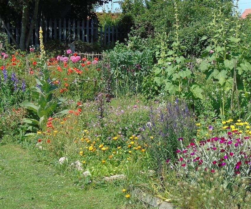
Alresford Neighbourhood Plan
CONTENTS
1 INTRODUCTION ................................................................................................... 1
Purpose of the plan ........................................................................................................................................................ 1
Policy context .................................................................................................................................................................... 1
Monitoring the Plan ....................................................................................................................................................... 4
2 LOCAL CONTEXT .................................................................................................. 5
History of Alresford ........................................................................................................................................................ 5
Profile of the community today ................................................................................................................................. 6
Main infrastructure issues in Alresford .................................................................................................................10
3 VISION AND OBJECTIVES.................................................................................. 19
Challenges for Alresford .............................................................................................................................................19
Vision for Alresford .......................................................................................................................................................19
Neighbourhood Plan Objectives .............................................................................................................................20
4 SPATIAL STRATEGY ........................................................................................... 21
5 HOUSING ............................................................................................................ 23
6 MOVEMENT ........................................................................................................ 26
7 COMMUNITY INFRASTRUCTURE AND PUBLIC REALM .................................31
Local green spaces ........................................................................................................................................................31
Improvement of public realm ...................................................................................................................................37
Health and social care .................................................................................................................................................42
8 ENVIRONMENT AND HERITAGE ......................................................................44
Wildlife-friendly development .................................................................................................................................44
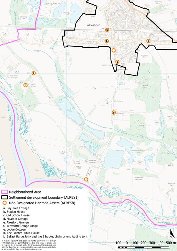
Non-designated heritage assets .............................................................................................................................46
Recreational disturbance ............................................................................................................................................51
Surface water management ......................................................................................................................................52
9 NON-POLICY ACTIONS...................................................................................... 53
10 POLICIES MAP ....................................................................................................54
APPENDIX A LIST OF SITES WITH UNIMPLEMENTED PLANNING
PERMISSION FOR HOUSING DEVELOPMENT IN ALRESFORD
PARISH, JULY 2019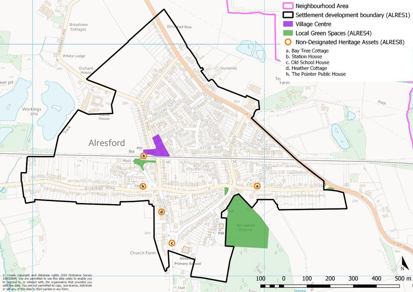
Alresford Neighbourhood Plan

 1    INTRODUCTION

      Purpose of the plan
1.1   This document represents the Neighbourhood Plan for Alresford parish for the period 2018 to
      2033. The Plan contains a vision for the future of Alresford and sets out clear planning policies to
      realise this vision.

1.2   The principal purpose of the Neighbourhood Plan is to
      guide development within the parish. It also provides
      guidance to anyone wishing to submit a planning
      application for development within the parish. The
      process of producing a plan has sought to involve the
      community as widely as possible. The different topic
      areas are reflective of matters that are of considerable
      importance to Alresford, its residents, businesses and
      community groups.

1.3   Some of the Neighbourhood Plan policies are general
      and apply throughout the Plan area, whilst others are site
      or area-specific and apply only to the appropriate areas
      illustrated on the relevant map. Nevertheless, in
      considering     proposals   for   development,      Tendring
      District Council will apply all relevant policies of the Plan.
      It is therefore assumed that the Plan will be read as a
      whole, although some cross-referencing between Plan policies has been provided.

1.4   The process of producing the Neighbourhood Plan has identified a number of actions which have
      not been included in the policies’ sections. This is because these are not specifically related to land
      use matters and therefore sit outside the jurisdiction of a Neighbourhood Plan. These actions will
      be addressed by the Parish Council outside of the Neighbourhood Plan process.

      Policy context
1.5   The Neighbourhood Plan represents one part of the development plan for the neighbourhood area
      over the period 2018 to 2033, the other parts being the Tendring District Local Plan (2007), the
      Tendring District Local Plan 2013-2033 and Beyond: North Essex Authorities’ Shared Strategic
      Section 1, the Essex Minerals Local Plan (2014) and the Essex and Southend-on-Sea Waste Local
      Plan (2017).

1.6   Tendring District Council, as the local planning authority, designated the Alresford Neighbourhood
      Area in November 2016 to enable Alresford Parish Council to prepare the Neighbourhood Plan.
      The Plan has been prepared by the community through the Alresford Neighbourhood Plan (ANP)
      Steering Group.

1.7   The ANP has been prepared in accordance with the Town & Country Planning Act 1990, the
      Planning & Compulsory Purchase Act 2004, the Localism Act 2011 and the Neighbourhood
      Planning Regulations 2012 (which were amended in 2015). The ANP Steering Group has prepared

                                                                                                           1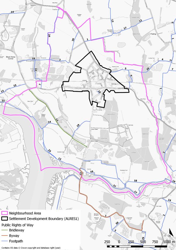
Alresford Neighbourhood Plan

the plan to establish a vision for the future of the parish and to set out how that vision will be
realised through planning and controlling land use and development change over the plan period.

        Figure 1.1: Alresford neighbourhood plan area/parish boundary

                                                                                                2
Alresford Neighbourhood Plan
1.8 The map in Figure 1 below shows the boundary of the Neighbourhood Plan area, which is the same
as the administrative boundary of Alresford parish.
1.9 Aspects of the Tendring Local Plan 2007 are considered to be out-of-date, based on the
requirements of the National Planning Policy Framework (NPPF). Whilst it is still part of the
development plan and its policies are used to determine planning applications (and therefore it
has been ensured that the ANP is in general conformity with its strategic policies), it does not
provide an up-to-date spatial framework to inform the development of the ANP. Rather, the
reasoning and evidence informing the policies in the emerging Local Plan has been taken into
account when preparing the policies in the ANP.
1.10 Tendring District Council is preparing a new Local Plan which is in two sections. The Section 1 Local
Plan covers strategic matters and has been jointly prepared by Braintree, Colchester and Tendring
Councils, assisted by Essex County Council. It was adopted in January 2021 and is now part of the
Development Plan. The Section 2 Local Plan, which specifically covers Tendring district, is being
examined and is expected to be adopted later in 2021. This Section 2 Plan is presented in the
Tendring District Local Plan Publication Draft (June 2017). The following are considered to be draft
strategic policy matters relevant to the preparation of the ANP:
Policy SP3 (Meeting Housing Needs) establishes that at least 11,000 new dwellings must be
delivered in Tendring district between 2013 and 2033. Principally this will be in the
Tendring/Colchester Borders Garden Community which will deliver 2,500 dwellings by 2033
(with 1,250 of these dwellings within Tendring district) and up to 9,000 dwellings in total
beyond the plan period.
Policy SP5 (Infrastructure and Connectivity) promotes more sustainable travel patterns
through, amongst other things, maximising the use of the local rail network.
Policy SP5 also seeks to ensure that essential healthcare is provided as part of new
developments. This is complemented by Policy HP1 (Improving Health and Wellbeing) which
commits Tendring District Council to work with the NHS and Public Health to ensure residents
can access high quality primary and secondary health care services. This includes supporting
general practitioners to deliver a service which meets the needs of local residents.
Policy SPL1 (Managing Growth) identifies Alresford as a Rural Service Centre but there is no
clear expectation to deliver a minimum number of dwellings.
Policy LP2 (Housing Choice) requires sites of 11 or more (net) dwellings to see a mix of housing
sizes, types and tenures which reflects the housing need in the latest Strategic Housing Market
Assessment. The policy also supports the development of bungalows, retirement complexes,
extra care housing, independent living, starter homes, self-build and other forms of residential
accommodation aimed at meeting the future needs of older and disabled residents as well as
family housing.
Policy LP5 (Affordable and Council Housing) requires 30% of all sites of 11 dwellings or more
to deliver 30% of these as affordable units.
Policy PP3 (Village and Neighbourhood Centres) identifies Alresford as a Village Centre and
seeks to protect and enhance it as a centre for day-to-day shopping needs.
3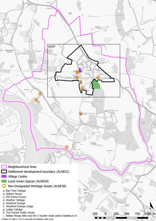
Alresford Neighbourhood Plan

1.11   Essex County Council (ECC) is the Minerals Planning Authority for the Plan area and is responsible
       for preparing planning policies and assessing applications for mineral development. The Essex
       Minerals Local Plan 2014 forms part of the statutory Development Plan and should be read
       alongside the Tendring Local Plan. Active and unworked sand and gravel deposits are subject to a
       Minerals Safeguarding policy (Policy S8), which seeks to prevent deposits being sterilised by non-
       mineral development. Part of the neighbourhood plan area is covered by sand and gravel deposits,
       and hence subject to Policy S8. Mineral Consultation Areas require ECC to be consulted on all non-
       mineral related development within a distance of 250m around active quarries, mineral
       infrastructure and mineral deposits permitted for extraction.

1.12   Essex County Council is the Waste Planning Authority for the Plan area and is responsible for
       preparing planning policies and assessing applications for waste management development. The
       Essex and Southend-on-Sea Waste Local Plan (WLP) was adopted in July 2017 forming part of the
       statutory Development Plan and should be read alongside the Tendring Local Plan. The WLP covers
       the period from 2017 to 2032. It sets out where and how waste management developments can
       occur and contains the policies against which waste management planning applications are
       assessed. In particular, Policy 2 seeks to safeguard waste management sites and infrastructure and
       provides criteria where adverse impacts of development proposals are unlikely to be opposed.

       Monitoring the Plan
1.13   Alresford Parish Council, as the Neighbourhood Plan authority, will be responsible for maintaining
       and periodically revisiting the Plan to ensure relevance and to monitor delivery.

                                                                                                       4
Alresford Neighbourhood Plan

 2    LOCAL CONTEXT

      History of Alresford
2.1   There have been settlements in and around Alresford (alders by the ford) since the Iron Age due
      to the benefits of a fertile soil and proximity to the once plentiful fish stocks of the River Colne
      Estuary. This provided countless generations of Alresford villagers with both food and trade.
      Agriculture is still important to the area although the coming of the railway in the 19th century
      gradually turned the village into a commuter base with workers travelling to Colchester and
      beyond.

2.2   The southern boundary of the village is formed by Alresford Creek, a tributary of the River Colne.
      The Creek is still navigable at high tide as far as Thorrington Tide Mill and provides moorings for a
      number of yachts. The old Roman Ford is clearly visible at low tide. To the west is the town of
      Wivenhoe, which can be reached by road or a footpath which follows the dismantled former railway
      line which ran adjacent to the river. This railway line opened in 1866 and was part of the ‘Tendring
      Hundred Railway,’ which went to Brightlingsea via a swing bridge over the Creek. It was a victim of
      the cuts in railway services of Dr Beeching and removed in 1964. The village of Elmstead Market
      borders Alresford to the north.

2.3   Fruit orchards and farms were once the predominant landscape features in and around Alresford,
      however housing development and the necessity to provide building materials means Alresford is
      surrounded by current and former gravel workings. The gravel was originally exported to London
      via sailing barges from Alresford Creek. The remains of a conveyor system from the processing
      plant to the creek can still be seen between offices of the current gravel company and the riverbank.

          Ballast barge jetty and bucket chain pylon gravel conveyor system, Alresford Creek

2.4   The village has a Primary School and a church. St. Andrew’s is a modern building constructed in
      1976 to replace the original St. Peter’s Church which was destroyed by fire in 1971. The shell of the
      original building remains and is a scheduled monument, with the War Memorial nearby. Scattered
      throughout the Parish are a number of listed buildings notably Alresford Hall and The Quarters, an
      especially attractive property which has altered very little externally since it was painted by John
      Constable almost two centuries ago.

                                                                                                         5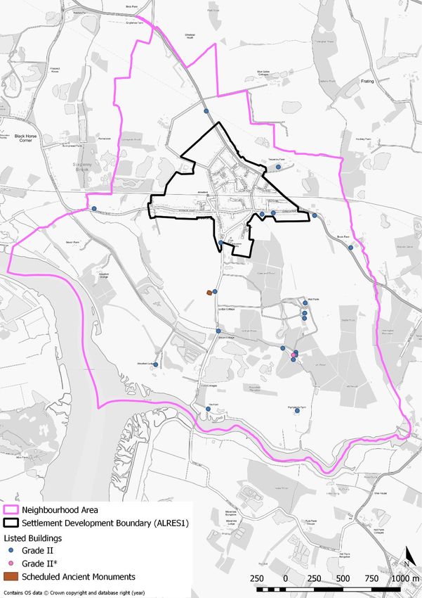
Alresford Neighbourhood Plan

                           St Peter’s Church before it was destroyed by fire in 1971

2.5     The Village Hall and playing fields in St. Andrews Close are much used facilities and attached to
        the Village Hall, is the ‘Pavilion’; home of the Colne Rangers Football Club and meeting place for
        Alresford Parish Council.

2.6     The centre of the village, which is identified on the Policies and Inset Maps, is approximately a mile
        north of the Creek and located around the railway station. For a relatively small village Alresford is
        hard to match for the quantity and quality of amenities. The railway station has clearly influenced
        the development and planning of the village during the past 150 years, including the migration of
        the village centre from near the old church to around the station. The main shopping centre is here
        and includes; a Post Office, take-away food shops, retail outlets and ‘The Pointer’ public house in
        nearby Wivenhoe Road. There are also numerous small businesses along Main Road and in
        Cockaynes Lane.

2.7     The main housing estates in the village were built in the 1960’s and 1970’s with a predominance of
        bungalows and a general mix of housing styles relating to those decades. In 2018 work commenced
        on a new housing development for 228 properties on sites either side of Cockaynes Lane.

2.8     Analysis of sites in the planning pipeline (i.e. with planning permissions or under construction) as
        at June 2019 in Alresford parish shows that there are 314 such dwellings. To put this in context, this
        represents a 36% increase on the number of homes in Alresford parish since 2011.

        Profile of the community today
 2.9    Unless stated otherwise, the profile of the community has come from the 2011 Census.

        Population

 2.10   In 2011, the population of the parish was 2,009. The age profile is generally in line with that of
        Tendring district and Essex county although Alresford does have a slightly higher proportion of
        people ages 45-64. In addition, its population of older retirement age (81+) is below Tendring
        district, which does have a very high proportion of people of this age (see Figure 2.1). One point
        to note from this is that, with a high proportion of people approaching retirement age, the
        population of people of retirement age is likely to increase significantly over the plan period.

                                                                                                            6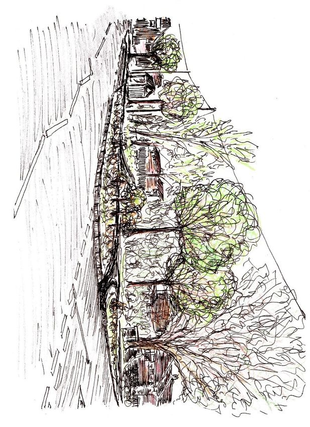
Alresford Neighbourhood Plan

       Figure 2.1: Population profile, 2011

                 81+

                65-80

                45-64

                30-44
          Age

                19-29

                17-18

                11-16

                 4-10

                  0-3

                        0%          5%            10%            15%           20%   25%       30%
                                                            % of population

                                                 Essex     Tendring      Alresford

2.11   Between 2001 and 2011, the population of Alresford decreased by 118 persons, a 6% fall compared
       with 6% growth across Essex county as a whole. What is particularly interesting is the change in
       population by age group.

       Figure 2.2: Change in population, 2001-2011

                                                81+

                                            65-80

                                            45-64

                                            30-44

                                            19-29

                                            17-18

                                            11-16

                                             4-10

                                                0-3

         -25%                -15%         -5%               5%              15%      25%       35%
                                         % change in population, 2001-2011

                                             Essex       Tendring      Alresford

                                                                                                             7
Alresford Neighbourhood Plan

2.12   Alresford experienced very strong growth in its retirement population (aged 65 and older) whilst
       also experiencing a decline in much of its population of working age (aged 19 to 64). This
       demonstrates not only an ageing population structure but also a declining workforce although, as
       shown in Figure 2.1, it still has a high population of older working age (45 to 64). Also, this could
       be partially offset by the increase in young people that will be of working age during the plan
       period (age 11 to 29). This is shown in Figure 2.2.

2.13   It is also important to note that this data reflects change over the period up to 2011. Since that
       time, a significant number of new dwellings have been built in Alresford, with an equally significant
       number in the planning pipeline. This is likely to have an impact on the age profile.

       Work

2.14   What is noticeable about Alresford’s population of working age (16 to 74) is that it has a
       comparatively high proportion of people in full-time employment. Alresford’s overall level of
       economic activity is broadly in line with Tendring district and Essex county. This is shown in Figure
       2.3.

       Figure 2.3: Economic activity, 2011

                                      Other
                  Long-term sick or disabled
               Looking after home or family
              Economically inactive student
                                     Retired
                Economically active student
                               Unemployed
        Self-employed without employees
              Self-employed with employees
                         Full time employee
                        Part time employee

                                               0%       5%      10%     15%    20%    25%     30%     35%     40%
                                                                   % of population aged 16+

                                                Essex        Tendring    Alresford

       N.B, ‘Economically active students’ are students who are also working as well as studying. ‘Economically inactive students’
       are not undertaking paid work in addition to their studies.

2.15   The large majority of those in work travel to work by car. This is supported by Census figures on
       access to a car by households. Over 90% of households have access to at least one car or van, with
       nearly half (46%) having access to two or more cars or vans. This represents high car ownership
       and is well above the district and county average.

                                                                                                                                8
Alresford Neighbourhood Plan
Figure 2.4: Car or van availability, 2011
4 or more cars or vans
3 cars or vans
2 cars or vans
1 car or van
No cars or vans
0% 5% 10% 15% 20% 25% 30% 35% 40% 45% 50%
% of households
Essex Tendring Alresford
2.16 In Alresford the car is the most heavily used mode of transport for travelling to work. The responses
to the Neighbourhood Plan survey carried out in 2018 reinforce the 2011 Census results shown in
Figure 2.5.
Figure 2.5: Mode of transport to work, 2011
Not in employment
Other
On foot
Bicycle
Car
Motorcycle
Taxi
Bus
Train, Underground
Work from home
0% 5% 10% 15% 20% 25% 30% 35% 40% 45% 50%
% of people of working age
Essex Tendring Alresford
9Alresford Neighbourhood Plan
Housing
2.17 The ownership profile of dwellings in Alresford shows that it is predominantly owner occupied, at
over 85% of all properties. This is well above proportion in Tendring and Essex at 74% and 71%
respectively. This is shown in Figure 2.6.
Figure 2.6: Ownership profile of housing, 2011
90%
80%
70%
% of households
60%
50%
40%
30%
20%
10%
0%
Owned Shared Social rented Private rented Living rent free
ownership
Alresford Tendring Essex
2.18 By contrast, Alresford has a very low proportion of social rented housing stock - just 4% compared
to 8% across the district as a whole and 14% across Essex.
2.19 In summary, the profile of Alresford is like that of many rural communities today, i.e. an ageing
population, with high levels of economic activity, car and home ownership. Whilst there are no
significant issues of deprivation which need addressing, the ageing population and the importance
of retaining the vibrancy of the local community are important issues for Alresford to address over
the lifetime of the plan.
Main infrastructure issues in Alresford
2.20 The issues below reflect the relevant issues in Alresford today, as informed by the three community
surveys undertaken as part of the development of the Neighbourhood Plan.
Railway
2.21 Alresford is predominantly a dormitory settlement and is dependent upon the railway for its very
existence. It was not until the railway was constructed in the village that the population grew and
even now this is a main route to employment for many of the inhabitants of the village. Today the
station still retains some buildings of importance to the history of the railway.
10Alresford Neighbourhood Plan
Alresford Railway Station and level crossing
2.22 Although there are four trains per hour using the line to provide access to Colchester, Clacton on
Sea and Walton on the Naze, only one train per hour in each direction stops to provide service to
these places.
2.23 The railway line provides an essential element of infrastructure for the village and this is expected
to increase in importance as the population of the village grows.
Roads
2.24 Alresford is dependent upon the roads network to ensure that inhabitants are able to access local
facilities in the nearby urban areas. Whilst the railway provides direct access to Colchester, Clacton
on Sea and Walton on the Naze it does not serve the surrounding villages of Brightlingsea, St Osyth
and Elmstead Market. Consequently these can be accessed easily by car owners but inhabitants
that do not have a car are very dependent on bus services.
2.25 Currently the village is served by a bus service along Wivenhoe Road connecting Alresford to
Brightlingsea, Wivenhoe, University of Essex and Colchester with four buses per hour daytime in
each direction Monday to Saturday with a much-reduced service in the evening. Sunday service is
restricted to a bus in each direction every two hours. There is also an hourly daytime bus service,
Monday – Friday, to and from Clacton-on-Sea and Walton-on-the-Naze. There is no service in the
evening or on Sundays.
The busy B1027, also a pedestrian route
11Alresford Neighbourhood Plan
2.26 For a rural village such as Alresford to remain a sustainable location, the provision of safe reliable
and convenient public transport is important.
Health
2.27 Health in the village is catered for by the Colne Medical Centre which is based at Brightlingsea
although there is a satellite surgery in the village. This building however is not owned by the Colne
Practice but is leased. Discussions with the Clinical Commissioning Group (CCG) have indicated that
there are no long-term intentions to provide a surgery at Alresford should the current tenure
situation change.
Alresford Surgery
2.28 This situation is of considerable concern to the community of Alresford. Should the surgery close
residents will have to travel to Brightlingsea for medical treatment which for many residents, who
do not have access to their own means of travel, means that they will be forced to rely on public
transport. The reductions in bus services which have occurred, and are likely to continue longer
term, means residents will find it increasingly difficult to receive medical attention.
2.29 In addition, the provision of a dispensary at the existing surgery gives residents a point in the village
where they can readily access prescriptions. It is important that this facility is maintained in order
to obviate the need for residents to travel to either Brightlingsea or Wivenhoe in order to have
access to pharmaceutical services.
Business and Employment
2.30 Gravel extraction is the largest business in the village and the ‘worked out’ gravel workings offer
opportunities for business development mainly in the leisure environment.
2.31 There are some smaller businesses located in Cockaynes Lane and HGV access to this site has
improved with the widening from Station Road to Pippin Way (the new road access to the largest
approved housing development), despite objections by local residents.
2.32 On the northern side of the B1027 is the Alresford Business Centre, a small business park with
approximately 20 units. There is land around this for further development but attention needs to
be given to access onto the B1027.
12Alresford Neighbourhood Plan
2.33 Many smaller businesses exist and several of these operate from resident’s homes and, even
though Essex University in nearby Wivenhoe is a major employer for the area, most residents travel
to Colchester, neighbouring towns and London for employment.
2.34 There are several farms in the parish but like all agricultural enterprises the use of labour is reducing
as farming becomes increasingly mechanised.
Education
2.35 The village has its own primary school but for secondary education pupils have to travel to
Brightlingsea or Colchester.
2.36 Extra accommodation has recently been provided at the Primary School and improvements have
been made to the play area. Further construction work is in progress to accommodate the
forthcoming population growth.
2.37 There is a Montessori Nursery in the village but there are few facilities for poorer families other
than family members and informal arrangements with relatives and friends. The provision off new
housing which has occurred over the past year has made the need for pre-school facilities ever
more pressing.
Footpaths and footways
2.38 There are many footways (pavements) in the village but on the whole these are poorly maintained
especially in respect of those associated with main roads. With increasing emphasis on public
health and associated health promotion a network of continuous and well maintained footways
are essential to promote safety and public health.
Cockaynes Wood Nature Reserve
13Alresford Neighbourhood Plan
‘Cut Throat Lane’ (Marsh Farm Lane) and views over the River Colne
2.39 Figure 2.7 shows the network of footpaths (public rights of way) in Alresford.
2.40 Many of the attractions within the village are not readily accessible by footpath and with respect
to the Creek, the public footpath to Wivenhoe and the ruins of St Peters Church can only be
accessed along a narrow lane with no footpath provision.
Car on narrow lane (Ford Lane)
2.41 Likewise, despite the walk from the village to Wivenhoe offering attractive views over the Colne
estuary along the Wivenhoe Road, there is no footway on a road that is narrow in places and has
fast moving traffic.
14Alresford Neighbourhood Plan
Figure 2.7: Public rights of way in Alresford
15Alresford Neighbourhood Plan
The Creek
2.42 Alresford Creek is a protected Area of outstanding Natural Beauty that is also a Biological and
Geological Site of Special Scientific Interest. This is a valuable asset to the residents of the village,
walkers, naturalists and sailors alike, to be managed and enhanced in line with the ECC HRA1 and
Essex coast RAMS2 criteria outlined in paragraphs 8.7-8.10 and Policy ALRES9. Alresford Parish
Council will continue to work in partnership with Colchester Borough Council and other
organisations in order to protect and conserve the Creek's unique natural environment.
Alresford Creek
Public Buildings
2.43 The two public buildings in Alresford are the Village Hall and The Pavilion which have been
extended to provide a range of facilities for the local population as well as being available for
people from further afield to hire.
Alresford Village Hall
2.44 The Village Hall is used six days a week for a range of activities for both adults and children. The
Pavilion is used by both youth and adult players of Colne Rangers Football Club. Alongside the
1 Habitats Regulations Assessment
2 Recreational disturbance Avoidance and Mitigation Strategy
16Alresford Neighbourhood Plan
Pavilion is the playing field that offers facilities for a range of sports and festivals throughout the
year.
The modern St Andrew’s Church
2.45 There is a relatively new church building, St Andrews, that has well apportioned accommodation
for many different community activities to take place. This space is also well used by the community
for a range of activities.
Historic Buildings
2.46 Alresford parish has 24 nationally listed buildings or structures. Of these, 22 are Grade II listed and
one is Grade II* listed. The remains of St Peter’s Church are a scheduled monument. These are
shown in Figure 2.8.
2.47 The only historic building in the village with open access for all is the ruins and graveyard of the St
Peter’s Church. Parts of this building date back to the twelfth century and exhibit the remains of a
roman villa.
The ruins of St Peter’s Church and graveyard
17Alresford Neighbourhood Plan
Figure 2.8: Listed buildings and structures in Alresford
18Alresford Neighbourhood Plan
3 VISION AND OBJECTIVES
Challenges for Alresford
3.1 The Alresford Neighbourhood Plan seeks to address, as far as possible, the challenges that face the
community of Alresford. This also reflects the objectives and issues identified and articulated in
Section 2 of the Tendring District Local Plan Publication Draft (June 2017) and other challenges
identified through the engagement process for the Neighbourhood Plan. In summary these
challenges are:
Ensure that any new homes developed cover the
broad demographic range of residents.
Encourage movement through and within the village
that promotes the wellbeing of parishioners and
visitors.
Maintain the special character of our natural
environment, whilst making it accessible to all.
Create a ‘heart’ for the community activity in the
village around the village hall, playing fields and
church and seek to better connect this with the other
area of primary activity around the shops, station and
pub..
Build on the current community-led stewardship of
Alresford to accommodate the planned 30%
expansion in housing over the next 3 years.
Vision for Alresford
3.2 A broad vision for Alresford as a ‘larger village’ in the ‘rural heartland’ of Tendring District has been
laid out in Section 2 of the Tendring District Local Plan Publication Draft 2017:
‘In the District’s substantial rural heartland, the smaller towns of Manningtree, Lawford, Mistley and
Brightlingsea, along with some of the larger villages, will have seen some modest levels of new
housing and employment development to support local shops and services, address local issues,
provide for local needs and facilitate investment by local businesses in job opportunities.’
3.3 The ANP builds on that vision and allows residents to make real choices about how they would like
their village to develop through the plan period by:
Understanding and promoting, at a local level, the housing needs for residents today and in
the future;
Providing and supporting clubs and facilities that offer opportunities for enhancing the
wellbeing of residents through exercise and social contact;
Providing a safe and flexible place for people to live, work and commute;
19Alresford Neighbourhood Plan
Protecting and improving the amenity value of the built and natural environment for residents
and visitors in both the local and wider community;
Nurturing and encouraging an environment that allows social enterprise to flourish through
volunteering and giving, to enhance the lives of all residents; and
Promoting residents' aspirations of remaining a walkable village with the station area at its
heart and providing an environment in which children and adults of all ages can flourish and
develop.
Neighbourhood Plan Objectives
3.4 The objectives of the Neighbourhood Plan as identified through engagement with the community
are as follows:
i. Objective 1: Housing – meet the particular needs of the community of Alresford for housing
and facilities as they arise over time, including serving the needs of an ageing population.
ii. Objective 2: Movement – Increase safe walking and cycling for local journeys through the
village.
iii. Objective 3: Community infrastructure and public realm – Protect and enhance the assets in
the village, including green spaces, community buildings and facilities and the local shopping
area.
iv. Objective 4: Environment and heritage – Preserve and enhance the environment and heritage
of Alresford, including its local wildlife and historic assets.
20Alresford Neighbourhood Plan
4 SPATIAL STRATEGY
4.1 The North Essex Authorities3 adopted Local Plan Part One (LPP1) is required to provide for
significant levels of housing growth in order to address the identified needs of the three districts
over the Plan period to 2033. For Tendring district, the housing requirement is 11,000 dwellings
over the period 2013 to 2033. The emerging Tendring Local Plan Part Two (LPP2) 4 identifies
Alresford as a ‘Rural Service Centre’, meaning that it will accommodate a ‘modest increase in
housing stock’5 that it will play a role in addressing local housing needs, supporting the village
economy and assisting with the overall housing growth proposed of the District.
4.2 The granting of planning permission on sites in Alresford totalling 314 dwellings6 between 2017
and 2019 means that no additional sites are currently allocated for further development in the
village. However, development will still be expected to come forward and it is therefore important
to develop a strategy which is clear about the appropriate locations for different types of
development.
4.3 The spatial strategy seeks to ensure that development is focused within the settlement
development boundary of Alresford, as shown in the Polices Map in Section 10, but that there is
flexibility around the development of uses that would enhance Alresford’s role as a Rural Service
Centre and address the needs of the local community. Policy SPL2 (Settlement development
boundaries) of the emerging Tendring LPP2 provides the strategic policy context focusing growth
within the settlement development boundary – which includes sites in the planning pipeline – but
considering appropriate uses outside the boundary, e.g. Policy LP7 (Self-build and custom-built
homes) and Policy LP10 (Care, independent and assisted living).
4.4 In Alresford, there are considerable needs relating to the ageing population. In light of this, the
provision of dedicated retirement housing, sheltered housing, extra care housing and care facilities
outside but adjacent to the settlement development boundary will be viewed favourably. Such
proposals would have to demonstrate that there are no other suitable sites within the settlement
boundary that are available or deliverable.
3 Braintree district, Colchester borough and Tendring district
4 The Submission Version of the Tendring Local Plan Part Two was submitted for Examination in October 2017.
The Examination of this Plan will commence once the LPP1 has been declared sound.
5 LPP2 Submission Version, paragraph 3.2.1.3.1
6 Source: Tendring District Council planning application database (see Appendix A)
21Alresford Neighbourhood Plan
POLICY ALRES1: ALRESFORD SPATIAL STRATEGY
A. New development in Alresford parish shall be focused within the settlement
development boundary of Alresford village as defined on the Policies Map.
B. Development proposals within the settlement development boundary (as defined on
the Policies Map) will be supported subject to compliance with the other policies in
the Development Plan.
C. All residential development proposals will be expected to address the following key
matters:
i. Ensure they address the evidence-based housing needs of the Alresford
Neighbourhood Area; and
ii. Contribute as necessary towards education infrastructure and other key
infrastructure which shall include health, transport and movement,
community facilities, utilities and public realm improvements, through direct
provision and/or developer contributions (including Community
Infrastructure Levy and/or Section 106).
D. The provision of housing and care facilities that meet the needs of older people will
be supported in the countryside immediately adjacent to the settlement development
boundary in accordance with Policy ALRES2. Such proposals must demonstrate that
there are no other alternative sites that are suitable or deliverable.
22Alresford Neighbourhood Plan
5 HOUSING
5.1 The importance of delivering a range of housing to address the needs not only of Alresford but
also, to a limited degree, the wider needs of the housing market area is significant. The Strategic
Housing Market Assessment covering Tendring district7 recognises that Tendring district has some
very specific housing needs. In particular, it forecasts that the number of people aged 65 or over
with a limiting long-term illness that limits them a lot will grow by nearly 3,800 (37%) across the
district over the 15-year period to 20308. As a result, the district will have by far the highest number
of such people of all the four districts in the housing market area.
5.2 In terms of specialist accommodation, this expected growth of people aged 65 or over with a
limiting long-term illness will mean a need for significant additional sheltered and extra care
housing units across the district over the plan period. The vast majority of this need is forecast to
be for sheltered housing.
5.3 In terms of demand, forecasts from Essex County Council show that in the Tendring district in 2019
there are a total of 11,008 households with at least one person over the age of 75 and 20,467
people over the age of 75, of which 405 have a care package funded by ECC of between 6-15 hours
of care a week (6 hours is currently the minimum care hours criteria for Extra Care).
5.4 There are currently three Extra Care schemes in the Tendring district - Rosebank Park (70 units) in
Harwich, Beaumont House (60 units) in Walton and Canters Meadow (30 units) in Clacton, with an
additional scheme in Clacton, Coppins Court (60 units), due to commence development in Spring
2020.
5.5 As at late-2019, Essex County Council is forecasting a current need for 292 units of Extra Care in
Tendring district.
5.6 Reflective of this significant district-wide demand, the theme of housing and care provision for the
elderly was raised as an issue of concern by local people consistently throughout the development
of the ANP. A Housing Needs Survey was undertaken in late-2017 and published in 20189 which
found that 70% of respondents10 considered themselves to be in need of alternative
accommodation within the next two years. Of these, 57% were seeking a 2-bed property. Whilst
the survey did not analyse the age of each respondent, the older age profile of the parish means
that it is likely a significant proportion of these short-term needs are by older people. In the detailed
survey to inform the ANP, 85% of respondents supported the provision of warden-controlled
sheltered housing for older people of those with mobility/health issues.
5.7 It is important that any housing or care facilities which address the needs of the ageing population
must be well located in respect of shops and services. This is particularly the case for housing types
where residents are more independent and mobile, therefore need to be able to shop and access
local services. This relates to retirement complexes, extra care housing (also known as ‘very
7 HDH Planning & Development (2015) Braintree, Chelmsford, Colchester and Tendring Councils Strategic Housing
Market Assessment Update
8 SHMA Update, Table 6.3
9 RCCE (2018) Alresford Housing Needs Survey, for Alresford Parish Council
10 The survey had a 25% response rate
23Alresford Neighbourhood Plan
sheltered housing’) and sheltered housing. A care home has more flexibility in where it is located
because its residents have their day-to-day needs provided on site.
5.8 Policy ALRES2 works with Policy ALRES1 to maximise the opportunities available for provision of
housing and other facilities to meet the full range of needs of older people. This includes care
homes, sheltered housing and extra care housing that are likely to be a mix of tenures as well as
retirement complexes which may be privately provided. Equally though, market housing which is
open to all people can still meet the needs of older people if designed with their needs in mind,
e.g. are capable of adaptation as people’s needs change over time. What will help to integrate such
housing developments into the community of Alresford is if they are brought forward as
community-owned schemes which are designed in a way to maximise community cohesion. Rural
exception sites11 and community land trusts12 are good examples of local ownership and co-
housing is a way of providing housing specifically designed to operate as a community as opposed
to a series of individual private units. Such examples of development were recommended in the
Alresford Housing Needs Survey. Alresford Parish Council will work with landowners and providers
of affordable housing13 to ensure that such provision is maximised and that opportunities for
people with a local connection to access such housing are provided.
POLICY ALRES2: PROVISION FOR THE AGEING POPULATION
A. In order to address the needs of older people in Alresford, development that provides
housing and care facilities specifically designed to address their needs will be
supported. This includes the provision of sheltered housing, retirement complexes,
extra care housing and specialist care facilities (Class C2).
B. Provision of housing for older people is encouraged to be delivered through
mechanisms which retain local ownership and maximise community cohesion, e.g.
rural exception sites, community land trusts, co-housing or almshouses.
C. The provision of any type of housing for the ageing population that does not provide
on-site care should ensure there is safe and easy access within reasonable walking
distance to the shops, services and bus stops in Alresford village.
11 Rural Exception Sites are small sites used for affordable housing in perpetuity where sites would not normally
be used for housing. Rural exception sites seek to address the needs of the local community by accommodating
households who are either current residents or have an existing family or employment connection. A proportion of
market homes may be allowed on the site at the local planning authority’s discretion, for example where essential
to enable the delivery of affordable units without grant funding.
12 Community Land Trusts (CLTs) are set up and run by ordinary people to develop and manage homes as well
as other assets. CLTs act as long-term stewards of housing, ensuring that it remains genuinely affordable, based on
what people earn in their area.
13 Affordable housing is defined as housing for sale or rent, for those whose needs are not met by the market
(including housing that provides a subsidised route to home ownership and/or is for essential local workers). This
can either be affordable housing for rent, Starter Homes, discounted market sales housing (sold at a discount of at
least 20% below local market value) or other routes such as shared ownership.
24Alresford Neighbourhood Plan
5.9 It should be noted that, whilst Policy ALRES2 addresses specific types of provision for older people,
this does not mean that the needs of other types of resident are not considered important. The
engagement with the community of Alresford to inform the plan preparation showed that the
needs of first-time buyers and families were equally important. However, policies to ensure that
new developments provide a mix of the housing that is needed in an area are being developed
through the Tendring District Local Plan Publication Draft (Policy LP2, as described in paragraph
1.10 of the Neighbourhood Plan). To duplicate such policies is unnecessary.
5.10 Policy ALRES2(C) directs housing for the ageing population that does not provide on-site care to
be located within ‘reasonable walking distance’ of shops, services and bus stops. There is no precise
definition of ‘reasonable walking distance’ or what represents ‘easy access’ but this must take into
account the fact that the intended occupiers will be older and comparatively less mobile than those
without specific needs and that any routes must minimise difficulties associated with crossing roads
or navigating routes where levels change.
25Alresford Neighbourhood Plan
6 MOVEMENT
6.1 As a rural village, movement is predominantly by car, particularly where residents need to travel to
work and shops and services for all bar the most basic everyday goods. The railway station does
provide an alternative for journeys to Colchester and beyond but, as the Census information shows,
car ownership in Alresford is high.
6.2 Alresford is situated on the B1027, one of the main routes connecting Clacton to Colchester. It
therefore has significant amounts of traffic using it, including heavy goods vehicles. The speed of
traffic along this route (a 40mph speed limit) coupled with the narrow pavements and lack of
dedicated cycle paths, makes it unattractive for walking, wheelchairs and cycling.
Narrow pavement along the B1027
6.3 Improved access for pedestrians and cyclists is needed to help link Alresford with the surrounding
villages, particularly Thorrington and Wivenhoe – this relates to the leisure routes which are
discussed below. This is important because the survey undertaken to inform the ANP showed that
whilst nearly 9% of respondents walked to work and nearly 5% cycled, the inadequacy of the
footpaths discouraged people from walking.
6.4 An example of a safer route is along the B1029 between Thorrington Mill and Brightlingsea Church,
where pedestrian and cycle access is largely separated from the vehicular traffic on the road. If an
equivalent roadside footway were provided alongside B1027 to Thorrington that would allow safe
cycling and walking to Thorrington and Brightlingsea and connect Alresford residents to a greater
range of shops and services, as well as access to employment opportunities on foot and by bicycle.
26Alresford Neighbourhood Plan
Dedicated footpath and cyclepath along B1029 between Thorrington Mill and
Brightlingsea Church (source: Google Streetview)
6.5 In addition, greater pedestrian movement can be encouraged with safe crossing of the B1027. In
particular, access to the Alresford Business Centre on the east side of the B1027 close to the
junction with Coach Road could be improved with a suitable pedestrian crossing.
Requirement for safe pedestrian crossing of Alresford Business Centre at junction of B1027
and Coach Road (source: Google Streetview)
6.6 One issue for children is the difficulty for many of walking safely to Alresford Primary School. The
school is in the south of the village but for those in the north, there is the need to cross Wivenhoe
Road, on which along its length through the village, there is only one dedicated crossing. Parents
reported that this discouraged many from allowing their children to walk to school. It is important
that there are safe routes to school to encourage more walking by children.
27Alresford Neighbourhood Plan
Junction of Ford Lane and Coach Road
6.7 As well as along the main transport routes, improvements to leisure walking routes can help to
provide access between Alresford and the surrounding villages. There are a number of existing
footpaths providing access to the adjacent villages. These footpaths are ancient rights of way across
fields and are used for leisure, health and dog walking as ground conditions permit. None can be
considered safe routes as they are all remote rural byways:
To Wivenhoe
Just to the north of Alresford village from Cockaynes Lane via Cockaynes Wood and
Sunnymead Farm
From Alresford Creek along the old railway track bed.
To Brightlingsea
From Alresford Creek via Thorrington Mill.
To other villages
From Tenpenny Farm, adjacent to the village on the east side of the B1027, to Frating, Great
Bentley and Thorrington via the lane off the B1027 opposite Coach Road
From Bluegates Farm, to the north of the village on the east side of the B1027, to Frating and
Elmstead Market via the farm drive off B1027 opposite Cockaynes Lane.
28Alresford Neighbourhood Plan
Tenpenny Cottage on the path to Frating
6.8 These routes which start on the east side of the B1027 would benefit from a safe pedestrian
crossing from the Alresford village side of the road as highlighted earlier. Safe crossing points may
also encourage people from other remote residences to use these routes and use the shops in
Alresford.
POLICY ALRES3: ENHANCING WALKING AND CYCLING IN AND AROUND ALRESFORD
A. In order to enhance movement by means other than the private car, major
development14 must prioritise the enhancement of the network of safe routes for
walking, both within Alresford village (in particular ‘safe routes to school’) and linking
Alresford with neighbouring villages. Further enhancement to provide cycle access,
particularly where this is separated from vehicular traffic, is also encouraged.
B. The Public Rights of Way network must be protected. Where appropriate, in
accordance with the statutory tests in the Community Infrastructure Levy Regulations
2010, development should enhance the Public Rights of Way network by improving
routes or creating new links. Linking the Public Rights of Way network to the new or
existing safe routes for walking and cycling is encouraged.
14 ‘Major development’ is defined in the NPPF as: For housing, development where 10 or more homes will be
provided, or the site has an area of 0.5 hectares or more. For non-residential development it means additional
floorspace of 1,000m2 or more, or a site of 1 hectare or more, or as otherwise provided in the Town and Country
Planning (Development Management Procedure) (England) Order 2015
29Alresford Neighbourhood Plan
6.9 Alongside Policy ALRES3, the ANP also identifies a list of priority projects for investment. These
projects are not only seen as the most important opportunities to increase walking and cycling for
leisure and health benefits on a day-to-day basis, but also to increase the use of circular routes
that link Alresford with the surrounding villages and are one of the most enjoyable leisure activities
for residents. The list of priority projects (not listed in any order of individual priority) is shown
below.
PRIORITY PROJECTS TO ENHANCE WALKING AND CYCLING
Dedicated footpath and cycle path (wide enough for disabled access) along B1027 to
Thorrington
Safe pedestrian crossing of the B1027 to access leisure walking routes at Tenpenny
Farm and Bluegates Farm
Dedicated footpath along Wivenhoe Road linking up circular leisure routes
Enhancement of the footpath along the creek between Ford Lane and the old railway
track-bed to allow all abilities to enjoy that environment.
30Alresford Neighbourhood Plan
7 COMMUNITY INFRASTRUCTURE AND PUBLIC REALM
Local green spaces
7.1 Under the NPPF, Neighbourhood Plans have the opportunity to designate Local Green Spaces
which are of particular importance to them. This will afford protection from development other
than in in line with national policies for managing development in Green Belts. Paragraph 100 of
the NPPF says that the Local Green Space designation should only be used where the green space
is:
in reasonably close proximity to the community it serves;
demonstrably special to a local community and holds a particular local significance, for
example because of its beauty, historic significance, recreational value (including as a playing
field), tranquillity or richness of its wildlife; and
local in character and is not an extensive tract of land.
7.2 Alresford Playing Field, the Millennium Garden, the Community Garden and allotments and the
Wivenhoe Road Rose Garden are considered to fulfil all of the criteria of the NPPF.
7.3 These areas are complemented by a number of other green spaces that are proposed for
safeguarding in Policy HP4 (Safeguarded local greenspace) of the emerging Tendring LPP2,
although this is a different type of designation which permits the loss of the green space subject
to certain criteria, including its satisfactory re-provision. The designation in Policy ALRES4 in the
ANP provides a higher level of protection which reflects the value of the local green space in its
specific location as well its importance as a space.
7.4 Several areas of high environmental value are not included as Local Green Spaces. In particular this
includes the Upper Colne Marshes and Colne Estuary Sites of Special Scientific Interest (SSSI), which
include Alresford Creek. Given their status, these areas already have a significant level of protection
which would not be added to by designation as a Local Green Space.
Alresford Playing Field
7.5 The Playing Field area is approximately 3.2 hectares and is owned by the Parish Council. It is very
widely used, being the only green space in the village suitable for sport and leisure. Its main uses,
as well as informal leisure and walking are:
Alresford Colne Rangers FC is the resident football club, with male and female teams at both
youth and adult level. These teams attract approximately 70 visiting clubs each season for
matches. It is estimated that approximately 2,000 people play football on the pitches each year.
Other facilities comprise cricket, tennis, skateboarding, jogging, fitness training, basketball. All
these are well used facilities.
Village fetes, shows and music events are held annually.
7.6 There are two play areas adjacent to one another and are well used throughout the year. A larger
area is provided for ages 6 to 16 years and a smaller area for infants. Both areas are enclosed with
low level fencing and are equipped with good quality equipment. A few bench seats are provided
for parents, grandparents and child minders.
31Alresford Neighbourhood Plan
7.7 Much loved and well used, the playing field has won numerous countywide awards and the village
is very proud of this important facility. In the 2017 Community Survey, when asked what is good
about living in Alresford, 13% of unprompted responses identified the Playing Field as a particular
feature. It was also the most commonly identified specific location which the community
considered to be of value to them. Being the only green space dedicated to formal leisure in the
village, the community considered it was a high quality space which did not require improvement.
However, with a lack of alternatives, its retention as a playing field is very important to people.
Alresford Playing Field
Millennium Garden
7.8 The area covered by the Millennium Garden is approximately 0.04 hectares and is owned by the
Parish Council. Whilst a small area, it is in a very visible location in the heart of the village, being on
the junction of Ford Lane and Wivenhoe Road. It is adjacent to bus stop and so it is an attractive
place for people to wait for the bus. In 2001, a time capsule was laid in the Garden and a stone
place on top to commemorate this.
32Alresford Neighbourhood Plan
Millennium Garden
Community Garden
7.9 The Community Garden by Alresford Station is owned by Abellio Greater Anglia and has relatively
recently been turned from a derelict piece of ground into a high quality community space covering
0.1 hectares. Here people can sit and spend some quiet time and for this reason it is enjoyed by
both young and old. The fact that it has been so well received since it was transformed
demonstrates how much the community values such spaces and, given the lack of alternatives, why
the space is so important.
Community Garden Local Green Space
33You can also read