AMMONIA & NITROGEN DEPOSITION RESULTS - Roger ...
←
→
Page content transcription
If your browser does not render page correctly, please read the page content below
AMMONIA &
    NITROGEN
    DEPOSITION
    RESULTS

    Erection of an 8,000 Bird
    Extension to the existing
    Free Range Poultry Unit at
    Gwynfaes
    Rhandirmwyn
    Llandovery
    Carmarthenshire
    SA20 0NG

    Prepared for AS, S and
    ME Reah

    Roger Parry & Partners LLP
    www.rogerparry.net
    gail@rogerparry.net
    Tel: 01691 655334
1
1.      INTRODUCTION

It is proposed to erect a Poultry Unit extension, 8,000 free range birds (egg
production) to the existing poultry unit at Gwynfaes, Rhandirmwyn,
Llandovery, SA20 0NG.

12 years ago 100% of the poultry units at Gwynfaes were deep pit. Post
proposal 60% of the units at Gwynfaes will be multi-tier units with manure
belts running for manure removal every 4 days. Thus only 40% will be in deep
pit with most of the manure removal occurring at the end of a flock cycle.

The purpose of this Report is to explain and examine if the proposed
development will have any impact on the ecological interest of the area.
Particular note is given to the levels of ammonia that shall arise from the
proposed extension and the cumulative impact of adjoining units.

2.     ENVIRONMENTAL SITES

Within a 5km radius of the application site there are three Sites of Special
Scientific Interest and within a 10km radius there are four Special Areas of
Conservation and one Special Protection Area.

     1) Cwm Doethie-Mynydd Mallaen SSSI

       This site, consisting largely of steep-sided valleys and upland tracts, is
       of outstanding interest for its wealth of habitats and wildlife, in particular
       its birdlife. Included are herb-rich grasslands and alder-fringed rivers in
       the valley bottoms, remnants of sessile oakwood and heath on the
       steep rocky valley sides, and upland grassland, moorland and blanket
       bog on the unenclosed sheepwalk on the plateau areas. Crag and cliff
       plant communities are frequent. On the valley sides of the rivers
       Doethie and Pysgotwr there are fine sessile oakwoods containing large
       maiden oaks and occasional ash, alder, birch, elm and rowan. The
       diverse ground flora has an abundance of mosses and liverworts and

                                         2
the older trees support a rich epiphytic lichen flora. Gorge woodlands,
      particularly in the Cothi and Melyn valleys, also contain notable
      assemblages of lower plants. In all these woods there is a rich variety
      of small birds.
      Uncommon plants occurring in the site are globeflower Trollius
      europaeus, parsley fern Cryptogramma crispa and lesser clubmoss
      Selaginella selaginoides, the latter growing in the most southerly site
      known in Britain. The rocks at Craig Ddu and Craig Clyngwyn support a
      remarkable variety of calcicole species, notably marjoram Origanum
      vulgare, wall lettuce Mycelis muralis, fairy flax Linum catharticum, the
      rare hawkweed Hieracium lasiophyllum and rock stonecrop Sedum
      forsteranum, together with at least eighty other species of higher
      plants.
      The site is noted for its variety of upland and woodland birds. It is
      especially important for its strong populations of carrion-feeding
      species, such as buzzard and raven; the rare red kite also occurs.
      Among the other upland birds are peregrine falcon, merlin, red grouse
      and ring ouzel, while golden plover has bred in the past. Typical bird
      communities of Welsh native woodland, including redstart, pied
      flycatcher, wood warbler and tree pipit are very well represented. The
      rivers and streams hold dipper, grey wagtail
      and common sandpiper, with the goosander as a very recent colonist.
      Farmland in the
      Gwenffrwd valley and elsewhere is included in the site because it forms
      part of the
      habitat of some of these birds or their prey.

   2) Cwm Doethie-Mynydd Mallaen SAC

   3) Elenydd – Mallaen SPA

Elenydd-Mallaen has, until recently, provided the last refuge for the red kite
Milvus milvus in
Britain and the long association with pastoral agriculture, principally sheep
rearing, has created an
important carrion-feeding bird community. The breeding density of raven
Corvus corax is the

                                      3
highest recorded in Europe and the density of buzzard Buteo buteo is also
high.
Elenydd-Mallaen is one of the most ornithologically important areas of hill land
in Wales and is
dominated by blocks of upland rising to 645m separated by steep-sided
valleys. The higher ground
has heath and blanket mire, characterised by heather Calluna vulgaris and
hare's-tail cottongrass
Eriophorum vaginatum or deergrass Trichophorum cespitosum. Much of the
area is dominated by
mat-grass Nardus stricta, heath rush Juncus squarrosus or purple moor-grass
Molinia caerulea.
Actively growing pool and hummock mire is found at Cors Lwyd and at Gors
Goch. Crags with
interesting plant communities are frequent. These areas, together with some
of the hillside and
streamside flushes support rare plant species.
Many of the valley sides are clothed with sessile-oak Quercus petraea
woodland, which in places
have a rich bryophyte and lichen flora. Occasional ash Fraxinus excelsior,
alder Alnus glutinosa, elm
UImus glabra, birch Betula pubescens and rowan Sorbus aucuparia add to
the variety of the
woodlands. Fast-flowing rivers run down the valleys creating gorges which,
together with the many
crags and scree slopes, support bryophyte communities confined to the
Western Atlantic seaboard.
Some of the valley floor grasslands support herb-rich communties.
The Elenydd-Mallaen proposed Special Protection Area comprises land within
the following SSSI;
Cwm Doethie-Mynydd Mallaen, Elenydd, Vicarage Meadows, Rhosydd
Llanwrthwl, Caeau Cnwch a Ty'n-y-graig, Cwm Gwynllyn, GweunyddTy'n-y-
llidiart, Coedydd
Glannau a Cwm Coel, Rhos-yr-hafod, Coed-yr-allt-goch, Caeau Troed-rhiw-
drain, Cerrig Gwalch,
Carn Gafallt, Marcheini Uplands, Gilfach Farm
and Gamallt, and Llynoedd Ieuan. .
The site qualifies under Article 4.1 by supporting internationally or nationally
important breeding
populations of 2 Annex 1 species: 34 pairs of red kite, (34% of the British
population and 0.3% of
the world population) and
about 7 pairs of merlin Falco columbarius (over 1% of the Bri tish population) .
Notable also are the
following 3 Annex 1 species: 1, sometimes 2, pairs of chough Pyrrhocorax
pyrrhocorax, part of a
small inland population that breed in dis-used lead mines arid quarries, over
10 pairs of peregrine
4Falco peregrinus (nearly 1% of the British population) and about 50 pairs of
golden plover Pluvialis
apricaria which are on the southern and western edge of their breeding range
in Britain.
The site also supports over 50 pairs of breeding raven (about 2% of the British
population). Present
also are small numbers of breeding teal Anas crecca, red grouse Lagopus
lagopus, dunIin Calidris
alpina, snipe Gallinago gallinago curlew Numenius arquata and ring ouzel
Turdus torquatus. Blackheaded
gull colonies occur on some of the upland pools. Breeding species along the
rivers include
goosander Mergus merganser, common sandpiper Tringa hypoleucos, grey
wagtail Motacilla cinerea
and dipper Cinclus cinclus.
SPA Citation
SJP September 1993
4) Rhos Dolau-Bran SSSI
This part of the valley of the river Brân supports a diverse range of natural and
semi-natural habitats. In this area of gravel ridges, oxbows, marsh, alder
woodland, river and river-bank habitats over 150 species of higher plants
have been recorded. Notable species include greater butterfly-orchid
Platanthera chlorantha. The site would appear to support an equally diverse
range of mammals, birds and invertebrates.
The continuing development of habitats of this kind is nowadays largely
precluded by modern agriculture and river works, which often eliminate or
reduce meanders and other features. This site demonstrates well these
declining habitats and shows the importance of such places for wild plants
and animals.
5) Crychan Forest Tracks SSSI
A composite site made up of four forest track cuttings, which together form a
key stratigraphic sequence in the type area for the Llandovery Series of the
Silurian system. The tracks are situated in the central part of Crychan Forest,
which lies a few miles north-east of Llandovery.
Scrach Track shows an almost continuous section across the Ordovician -
Silurian boundary, from the top of the Scrach Formation, through the Bronydd
and Crychan formations. The Ashgill-Rhuddanian (Ordovician - Silurian)
boundary lies within the Bronydd Formation which has graptolites of the
acuminatus Biozone near its base.
The locality at Cwm-coed-aeron shows informative track-side exposures in
Llandovery (Silurian) rocks of the Trefawr Formation. Also exposed is the
lower part of the Rhydings Formation, which has been interpreted as
representing open marine-shelf conditions resulting from a late Llandovery
transgression. This section yields a common brachiopod fauna and
5occasional graptolites, and is a key stratigraphic site in the type area for the
Llandovery Series of the Silurian system.
Coed Glyn Moch Track provides important sections through about three
hundred metres of strata of Llandovery age (Silurian). Rocks exposed belong
to the Rhydings, Wormwood and Lower Cerig formations, and contain
common shelly faunas, including brachiopods.
The long Tre-fawr track section exposes most of the Llandovery Trefawr
Formation. The sandy mudstones of this formation contain a graptolite and
shelly fauna. This section is the stratotype for the Aeronian Stage, defined at
the base of the triangulatus zone on this track. The graptolite fauna of this
zone is of worldwide occurrence, one reason for its selection as an indicator
of the base of the stage. Near the boundary the fauna consists mainly of
brachiopods, but bivalves, gastropods, cephalopods, trilobites, corals and
bryozoa also occur. This is a key stratigraphic site for studies of Llandovery
strata.
6) Afon Tywi SAC
7) River Wye SAC
68) Mynydd Epynt SAC
No details of SAC.
3. SCAIL MODELLING – ASSESSMENT OF AMMONIA
The SCAIL calculation stands for a Simple Calculation of Atmospheric Impact
Limits. It is a screening tool for assessing the impact from agricultural
sources on semi natural areas such as SSSI’s. The SCAIL model was
developed from the Integrated Pollution Prevention and Control (IPPC)
Directive which requires permits for pig and poultry systems with more than a
certain number of livestock. It is noted that for poultry units the IPPC directive
only applies to poultry units with more than 40,000 places. We emphasise
that the SCAIL model is only a precautionary approach to the assessment of
risk and actually provides the reader with the worst case scenario to the
impact of such developments.
The Environment Agency provide detailed Guidance regarding the Ammonia,
Nitrogen and Background levels together with sources, critical loads and
levels from farming operations within their document – “H1 Environmental
Risk Assessment for Permits, Annex B – Intensive Farming” December 2011.
The snapshot Table below is taken from the Environment Agency;
7It is noted that ammonia releases, odour and fugitive emissions (dust and
flies) are considered in this assessment.
No integrated Pollution and Prevention Control Permit is required for the free
range enterprise at Gwynfaes.
Ammonia is the emissions that is of most concern in this report, from animal
housing, manure storage, and manure spreading. The United Nations
Economic Commission for Europe (UNECE) has adopted critical levels for
ammonia to protect sensitive vegetation, the annual critical level average is 3
µ/m³.
As well as Housing of the Birds, the application of manure to the land can
have an impact on the designated site. The Application proposed will see
manure taken from the building every 4 days and broadcast spread on the
available farm land, in accordance with the Codes of Good Agricultural and
Environmental Condition and Cross Compliance Regulations.
In the worst case scenario if weather does not permit spreading, manure will
be stored in the existing manure store on farm. Please see Manure
Management Plan.
Manure will be:
1. Spread in suitable weather conditions.
2. At least 10 meters away from any water course.
3. Incorporated into the ground within a maximum of 24 hours after
application (weather dependant).
8SSSI Name Background levels Contribution to % Contribution CL for % % contribution
ammonia contribution to Nitrogen habitat contribution to N
average (NH3) to NH3 (N) (kg/ha/yr) to N critical background
concentration critical levels deposition loads (CL for level
from this (CL for from this habitat)
NH3 N (kg) proposal habitat is proposal
(ug) 3ug)* High Level
Cwm 0.86 20.44 0.10 3.33 0.78 10 7.8% 3.82%
Doethie –
Mynydd
Mallaen
SSSI
Cwm 0.86 20.44 0.10 3.33 0.78 10 7.8% 3.82%
Doethie –
Mynydd
Mallaen SAC
Elenydd- 0.86 13.58 0.10 3.33 0.52 10 5.2% 3.83%
Mallaen
Rhos Dolau- 1.09 21.42 0.07 2.33 0.55 10 5.5% 2.57%
Bran
Crychan 0.87 13.72 0.04 1.33 0.21 5 1.05% 1.53%
Forest
Tracks
9Afon Tywi 1.20 15.96 0.02 0.66 0.10 10 1.0% 0.63%
Afon Gwy 0.79 13.58 0.01 0.33 0.05 10 0.5% 0.37%
The above table summarises that the ammonia contribution from the proposal
on all SSSI’s are acceptable and are less than the critical load of range of 0-
8% and less than 1% for the SAC’s respectively.
The proposed development results in ammonia emissions lower than those
considered acceptable by both Natural Resources Wales and the
Environment Agency, who indeed have differing Critical Load Thresholds.
The Clients are proposing a free range laying unit where manure shall be
removed every four days thus reducing the ammonia emissions from the
proposal into the atmosphere. Upon application of manure to the land by
broadcast method, within 24 hours all manure shall be incorporated into the
land. The prevailing wind does not take exhaust air in the direction of the
SSSI.
The majority of the concentration of NHз comes from existing background
concentrations, in line with this the contribution from the proposal is not
considered unacceptable especially given the nitrogen measures outlined.
4. CONCLUSION
Earlier in this document it has been noted that the SCAIL model is a
precautionary approach to the assessment of risk. The SCAIL currently
available does not provide for detailed information such as topography and
vegetation to be taken into consideration.
The submitted planning application is for an extension to the existing poultry
unit to accommodate a further 8,000 free range birds, this is below the
required number of birds for the IPPC permit to be enforced.
The following points are noted with regards to the proposal.
1. The development proposed is of limited scale and operation,
underneath the requirements of the IPPC permit.
102. The entire enterprise is a free range unit where the birds are free
during the day to roam any part of the surrounding designated land.
Ammonia levels in the poultry unit proposed at Gwynfaes are extremely
low because the pop holes in the building are open from dawn to dusk
resulting in natural ventilation through the building.
3. Manure is taken out on a 4 day cycle reducing the manure standing in
the building and thus reducing ammonia levels.
In reviewing the poultry unit proposed at Gwynfaes it is concluded that there
would be no detrimental impact upon environmental sites within 5km and
10km of the development.
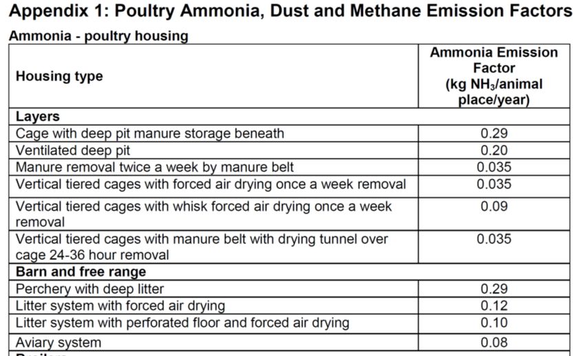
APPENDIX 1
1112
You can also read